
Paracel Islands
 | |
| Geography | |
|---|---|
| Location | South China Sea |
| Coordinates | 16°30′N 112°00′E / 16.500°N 112.000°E |
| Administration | |
People's Republic of China | |
| Demographics | |
| Population | some military personnel, no permanent residents |
The Paracel Islands consist of over 30 islets, sandbanks or reefs, occupy about 15,000 km2 of the ocean surface, and located in the South China Sea, also known as East Vietnam Sea or East Sea. Turtles live on the islands, and seabirds have left nests and guano deposits, but there are no permanent human residents except for a small number of troops. The archipelago is approximately equidistant from the coastlines of Vietnam and China, and about one-third of the way from central Vietnam to the northern Philippines. The islands are divided into two main groups. The Amphitrite group is in the northeast and the Crescent group is in the southwest, and about 70 km from one another. Subject to hot and humid climate, with abundant rainfall and frequent typhoons, the archipelago is surrounded by productive fishing grounds and potential oil and gas reserves. Notably, up until the early 19th century, the present-day Spratly Islands were still delineated as part of the Paracel archipelago, and that the sovereignty over the islands has been inflaming the century-old dispute.
Amphitrite Group
The Amphitrite group, or lesser known Actaeon group, was named after the Tahitian merchant vessel Amphitrite by Mr. Thomas Ebrill in 1833. Lying in the most northeastern of the Paracel Islands, at the coordinates of 16.97 degrees North and 112.28 degrees East, the group consists of six low narrow islands with sand cays; enclose shallow lagoons, connected by reefs of rock, and about 37 km northwest from Lincoln Island. The northern section of the group comprises South Island, Middle Island, North Island, and Tree Island. The last unit lies toward the eastern tip of this section with coconut palm trees seen on the island. Together they form the upper branch of an ellipse of 22 km long semimajor axis that approximately orientates from west to east. The southern section consists of two islands called Woody and Rocky Islands lying very near each other. The former located approximately 5 km southwards from the southern tip of the east extremity of the northern section. This feature is the largest island of the Amphitrite group.
Crescent Group

Duncan Islands
Drummond Island
Money Island
Antelope Reef
Robert Island
Pattle Island
Observation Bank
|
Lying about 70 km southwest of Amphitrite group, at the latitude of 16.52 degrees North and the longitude of 111.63 degrees East, this group consists of 8 islands and forms a crescent-like structure hanging from west to east and enclosing a deep central lagoon. The group measures 31 km and 15 km in length and width, from east to west and from north to south, respectively. All of the islands of the group are vegetated except for small cays. Located in the southwestern extremity of the group, at the hanging point of the crescent structure, is the Money Island. This feature has some small cays in the southern side. The Antelope Reef, submerged at high tide and containing a central lagoon, lies at the eastern side of the island of Money. Respectively, northeast of this reef are Robert and Pattle Islands. They are separated from each other by a 3.5 km wide, deep channel. The later is the largest island of the group; a lighthouse and a radio and weather station were built there on 1937. The Observation Bank situates at the northernmost of the Crescent group and contains a small cay; from the southeastern side lying a 12 km long, boomerang shaped reef with the island of Drummond. The last distinct unit of the atoll-like structure is the Duncan Islands group, which is approximately 3 km west of the Drummond Island and about 8 km east of the island of Antelope.
Other Features

- Bombay Reef: The elongated-structure reef situates at the southeastern corner of the Paracel Islands and lies approximately 90 km southeast from the Crescent Group. With most parts are submerged, the reef is measured approximately 18 km and 5 km from east to west and from north to south, respectively. The Bombay Reef encloses a deep lagoon with rocks on its edge.
- Bremen Bank: Located 24 km north from Bombay Reef, the submerged shallow bank is measured approximately 23 km in length from northeast to southwest. The shallowest area is about 12 m and located in the southwestern part of the bank.
- Discovery Reef: Measured approximately 27 km in length from east to west, and 7 km from north to south, the reef is located about 18 km south from the Crescent Group. Completely submerged, the elongated ring structure is the largest single reef of the Paracel Islands. The reef has two large, deep openings into the lagoon on the southern side.
- Itis Bank: Located 11 km south from the Amphitrite Group, this shallow bank is measured approximately 5 km in length with an average depth of 12 m.
- Lincoln Island: Surrounded by a coral reef, located 37 km southeast from the Amphitrite Group, the island is covered with brushes and fairly high trees, including coconut palm trees. The depth increases sharply on the northern and eastern sides of the island but the southern and south western regions are shallow. An observation post on the western side was found by officers of the German Government surveys in 1883. In 1948, Great Britain requested France for permission to use the feature for military exercises.
- North Reef: Situated approximately 56 km north from the Crescent group and about 70 km west-northwest from the Amphitrite group, the reef is the most northwesterly feature of the Paracel Islands. Most part of the reef is submerged. Ruggedly, rocks are around the edge and barely above water. There is a passage into the lagoon on the southwestern side of the reef.
- Passu Keah: This small reef encloses a shallow lagoon and located about 12 km south of eastern side of Discovery Reef, approximate 37 miles East-North-East from Triton Island. The sand cay measures 9 km in length.
- Triton Island: The vegetated sand cay stands on a steep-sided coral reef and measures 1.5 km in length. This southernmost island of the Paracel Islands lies far away from the rest and situates about 56 km southwest of Discovery Reef.
- Vuladdore Reef: Mostly submerged, the reef orientates from east to west, measures 12 km and approximate 3 km in length and width, respectively. Lying near the center of the Paracel Islands, this feature situates about 18 km west-northwest from Discovery Reef. Some small spiral rocks are seen on the reef.
Gallery
-
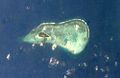
Northern section of Amphitrite Group
-
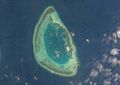
Crescent Group
-
 Money Island
 -
 Pattle Island
 -
 Robert Island
 -
 Antelope Reef
 -
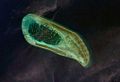
Woody Island
-
 Bombay Reef
 -
 Bremen Bank
 -
 Discovery Reef
 -
 Iltis Bank
 -
 Lincoln Island
 -
 North Reef
 -
 Passu Keah Reef
 -
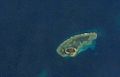
 Triton Island
 -
Vuladdore Reef


Historical Background of Disputes
The sovereignty of the archipelago has been the subject of disputes among China, Taiwan, and Vietnam since the early 20th century. Around the mid 18th century, after conquering Vietnam, France subsequently took over and administered the islands on behalf of her colony, and later annexed them as part of French Indochina in 1932. Upon France’s withdrawal from the country in 1956, Communist Chinese troops quickly occupied Woody Island, the main island of the Amphitrite group. The Pattle Island, the largest of the Crescent group, continued to be controlled by Vietnam, France’s successor. Tensions over these features continued to rise unceasingly since then and climaxed at the Battle of the Paracel Islands between the Republic of Vietnam and the People's Republic of China. After the bloody engagement, the latter seized the entire archipelago and has taken control of the islands since 1974; however, sovereignty disputes remain unresolved.
| Paracel Islands | |||||||||||
|---|---|---|---|---|---|---|---|---|---|---|---|
 | |||||||||||
| Chinese name | |||||||||||
| Traditional Chinese | 西沙羣島 or 西沙群島 | ||||||||||
| Simplified Chinese | 西沙群岛 | ||||||||||
| |||||||||||
| Vietnamese name | |||||||||||
| Vietnamese alphabet | Quần đảo Hoàng Sa | ||||||||||
History of the names of the islands
Hoàng Sa
The name of the islands, 黃沙, has been found in historic Vietnamese documents dating back to the 15th century.[1] In the modern language system it is written as Hoàng Sa or Cát Vàng. They all have exactly the same meaning that is the Golden Sands or the Golden Sandbank for a better visualization of the islands. Before the early 19th century, the present-day Spratly Islands were treated as the features of Hoàng Sa.[2][3] Only under the reign of Emperor Minh Mạng (1820-1841) when the Spratlys were distinctly delineated from the other and officially named Vạn Lý Trường Sa, the Ten-thousand-league Long Sandbank.[4][5] Historically, the Vietnamese language has taken several different paths. During the dynasty era, Hán tự and Chữ Nôm were formally used in the country. The former, the classical Chinese character, was more popular than the later and the most widely used to produce documents during the kingdom age. For instance, in Hán tự, Hoàng Sa is written as 黃沙. From the mid 17th century onwards, Quốc ngữ, the modern Latin-based alphabet spelling system was introduced and eventually recognized as the national language in the early 20th century. It is believed that a large number of Vietnamese documents relating to the islands was lost during the three major wars, including a thousand years of constant struggles and battles against the Chinese domination and aggression, a hundred years of waves of uprisings to regain independence from France, and more than two decades of bloody fighting among the Vietnamese themselves. This war-torn nation has witnessed many significant changes through out of its history, including the country name, but the name of the islands, Hoàng Sa, remains completely unchanged in more than five hundred years.
Pracel and Paracel
On the “Map of Europe, Africa and Asia” published in 1598 by Cornelis Claez, an unnamed band of rocks and sandbanks shown in the neighborhood of the present-day location of the Paracel and Spratly Islands. About two decades later, the names Pracel and Costa de Pracel (Coast of Pracel) appeared on the “Chart of Asia and eight city maps” published in 1617 by Williem Jansz Blaeu, a Dutch map maker. The coast belonged to the Kingdom of Cauchi China.[6]
As early as at the beginning of the 16th century, had the Portugese vessels frequented the South China Sea; then later came the Dutch, the English, the Spanish, and the French. They all wanted to become a major trader in the region of great opportunities commercially, but was still less known to the west. The name Paracel started replacing Pracel on maps and charts as the century passed. Typically, on the “Map of the coast of Tonquin and Cochinchina”, made in 1747 by Pierre d’Hondt, the dangerous band of rugged rocks was labeled "Le Paracel", a French phonetic notation. Because of its peculiarity on an important water channel, Ilhas de Pracel (Pracel Islands) had drawn much attention from navigators and hydrographers for several centuries. In addition, recent disputes have once again inflamed the popularity of the islands; but the origination of the terminology is still vaguely understood. There are different stories about the names but none of them are able to provide any convincing evidence.
The report "Paracel and Spratly Islands on Charts and Maps made by Westerners" by Dr. Dai-Viet Nguyen (Nguyễn Đại Việt) of Việt Nam Quốc Dân Đảng has shed light on the origin of the terminology.[6] Part of his findings included various citations, typically:
The coast of Brazil from Santa Catharina island to Maranluio presents a peculiarity which is worthy of remark; for it appears as though it were encircled by two bands of elevated ground (dentures de haut fonds), which, except in a few intervals, are continued throughout all its extent, and seem as if intended to defend the land from the encroachment and impetuosity of the waves, which continually lash the shores. One of these defences adjacent to the land is a ridge rocks, which forms a kind of border, extending principally from cape Frio to Maranhao. The other natural bulwark or defence of the coast is a bank, situated from 2 to 10 leagues from the land, generally of a moderate though irregular depth, which the natives term Pracel or Paracel, as all the depths are unequal and irregular where the inhabitants fish. It may be said that this Pracel the same as the recife...[7]
or,
Off Mount Melançia (Ion. 39 degrees 18’) before noticed a bank commences which thence extends all the way to the River Iguarassu, an extent of 45 leagues. This bank which is called in the country Pracel de Caracu from the name of the most considerable hamlet on this part of the coast, extends outward about 3 leagues from the shore, and is circumscribed by the depth of 6 fathoms...[8]
Ecologically, it is understood that the terminology was used to classify a certain islands, rather than being used as a proper noun. Notably, that class of islands seems to possess a number of special characteristics, which may be defined as follows:
Pracel is a moderately elevated chain of islets, sandbanks, and reefs. These features are continuously distributed and stretched over a noticeable distance of tens or hundreds of kilometers in length. Pracel may not be a suitable place for human residents, but its irregular depth creates an ideal environment inhabited by fish. Pracel often forms a natural bulwark as an outer line of defense for a coast or a land.[6]
Regarding the features off the coast of the Kingdom of Cauchi China, their structure closely fits the above description. By piecing all the elements together, undoubtedly, it is the Portugese people who purposely classified them as a pracel in their native language in the early 16th century. Approximately three hundred and fifty years later, in the early-mid 19th century, Ilhas de Pracel was devided into two archipelagos. From that time onwards, the names Paracel Islands and Spratly Islands have become more polular internationally and widely used on charts, maps, and related documents.
History of Sovereignty
China
- There are some Chinese cultural relics in the Paracel islands dating from the Tang and Song dynasty eras[9], and there is some evidence of Chinese habitation on the islands in these periods. [10].
Vietnam
15th - 17th Centuries
- 1460-1497, under the reign of Emperor Lê Thánh Tông, the Vietnamese began conducting commercial activities on and around Hoàng Sa, including harvesting abundant sea-products and conducting salvage operations on shipwrecks.[1]
- In 1634, under the Lê Dynasty (1527-1786), the ship Grootebroek of the Dutch East India Company sank in the vicinity of the Paracel archipelago. Using a small boat, captain Huijch Jansen and 12 sailors managed to reach Annam, territory of Lord Nguyễn Phước Nguyên (1613-1635), to seek rescue for other castaways remained on the islands.[11]

- 1680-1705, Lord Trịnh Căn instructed Đỗ Bá Công Đạo to publish Thiên Nam Tứ Chí Lộ Đồ, an encyclopedia consists of 4 series of maps that detail routes from Thăng Long, capital of Đại Việt, to other countries in the Southeast Asia. Part of this work was based on the Hồng Đức Atlas (Hồng Đức Bản Đồ) developed during the time of Emperor Lê Thánh Tông (1460-1497). This encyclopedia was considered one of the oldest and rarely preserved Vietnamese documents regarding the islands. The volume "Đường từ phủ Phụng Thiên đến Chiêm Thành" (The Route to Champa from Phụng Thiên Province), remarkably described the archipelago with maps. For instance, a statement found in the volume read "In the middle of the sea, there is a long sandbank called Bãi Cát Vàng, which is approximately 400-league long and 20-league wide rising up above the sea." Bãi Cát Vàng means Hoàng Sa, Golden Sandbank.[1][12]
- In 1700s, under instructions of the Nguyễn Lords, the salvage operations officially started with the formation of Hoàng Sa and Bắc Hải Companies. Their responsibility was to carry out the mission at Hoàng Sa (Golden Sandbank) and Vạn Lý Trường Sa (Ten-thousand-league Long Sandbank) respectively. This effort was continued thereafter with successive establishments of other naval task units in accordance with strategic policies toward the two archipelagos under the Nguyễn Dynasty. Noticeably, a number of naval battles between the Dutch fleet and the Nguyễn Royal Navy occurred in 1643 and 1644. The Hoàng Sa naval task unit consisted of 70 men recruited from An Vĩnh and An Hải villages of Quảng Ngãi, while the majority of members of the Bắc Hải Company came from Bình Thuận province.[1][13][4][14]
18th Century

- In 1776, the Phủ Biên Tạp Lục, the Miscellaneous Records on the Pacification of the Frontiers, published by Lê Qúi Đôn, a philosopher, an encyclopaedist, and a Minister of Construction of the Lê Dynasty (1527-1786). These six volumes detail the Nguyễn Dynasty's territories, including the exploitation of the Paracel and Spratly Islands from 1702 onwards.[1][13][14]
- 1777-1784, when traveling to Cochin China, Father Jean-Baptiste Grosier recorded his impression about maritime activities of the Vietnamese from Huế, Đà Nẳng, and Quảng Ngãi. The abbot Grosier wrote that the people from those ports were excellent and cleverest navigators in this Kingdom. One of their activities was making long distance sailing every year to the long chain of islands and rocks known as the Paracels to collect debris from shipwrecks.[15]
19th Century
- 1802-1820, under the reign of Emperor Gia Long, the territory of his kingdom included Tonkin, Cochin China, part of Cambodia, and "certain islands off the coast including the well known Paracels which bear such an evil reputation as a source of danger to navigation in the China Seas."[16]
- In 1807, the East India Company sent Captain Daniel Ross to Cochin China to survey the Paracel Islands. Upon arriving to the kingdom, he presented a letter of introduction entrusted by the English company to the reigning king, who was believed to be Emperor Gia Long at that time.[17] Subsequently, Captain Ross completed chartering the south coast of China in 1807, the Paracel Islands in 1808, part of the coast of Cochin China in 1809, and the coast of Palawan in 1810. Most notably, in his surveys published in 1821 under the title "(South) China Sea, Sheet I & II", the Spratly Islands was referred to as The Dangerous Ground, and was later renamed as Storm Island on the 1859 edition of the chart.[18] Separately, in another document, the "Correct Chart of the China Sea", published by Herbert in 1758, the Paracel archipelago was described as a long group of islands and reefs extending from 13 to 17 degrees North, which approximately correspond to the geographic latitudes of the present-day Spratly and Paracel Islands, respectively.[18] It is quite clearly that the captain himself, and probably most navigators of his time, did not differentiate the two archipelagos, but instead had delineated the present-day Spratly Islands as part of the Paracels. Captain Daniel Ross was a well known hydrographer of the Navy of Government of English Bengal and founder of the Bombay Geograpghical Society.[19]
- In 1815, Emperor Gia Long ordered Phạm Quang Anh's Hoàng Sa naval task unit to sail to the islands in order to make surveys and report on maritime routes and draw up maps.[14][20]
- In 1816, according to Jean-Baptiste Chaigneau, Emperor Gia Long officially claimed the sovereignty of the Paracel Islands, which would include the present-day Spratly archipelago. These two islands were later delineated distinctly under the reign of his successor, Emperor Minh Mạng. Chaigneau was one of the most respected advisors to Emperor Gia Long. He spent more than 30 years in Cochinchina and became the first French Consul to this kingdom in 1821.[21]

- In 1821, the Lịch Triều Hiến Chương Loại Chí published by Phan Huy Chú, a historian, an encyclopaedist, and an officer of the Ministry of Construction in the time of emperor Minh Mạng. This remarkable work was prepared in 10 years (1809-1819) and consisted of 10 volumes. One of them, the Địa Dư Chí volume, details territories of Dai Nam Kingdom. In 1838, he published the Đại Nam Thống Nhất Toàn Đồ, the Unified Đại Nam Complete Map, that distinctly delineated Vạn Lý Trường Sa (the Ten-thousand-league Long Sandbank) and Hoàng Sa (the Golden Sandbank).[4]
- In 1833, Emperor Minh Mạng ordered Ministry of Construction to build a temple, erect steles, and plant many trees on the islands for navigation purposes.[14][20]

- In 1834, Emperor Minh Mạng ordered Trương Phúc Sĩ, a naval task unit commander, accompanied by 20 men sailing to the islands to survey and draw map of Hoàng Sa.[1]
- In 1835, Emperor Minh Mạng issued a royal ordinance to order 24 troops to the Paracel Islands. The royal ordinance has been preserved by generations of Đặng family and was publicly disclosed in early 2009.[22]
- In 1835, the King ordered Phạm Văn Nguyên's naval task unit, accompanied by workers from Bình Định and Quãng Ngãi provinces, to build Hoàng Sa temple with a wind screen and erect steles on Bàn Than Thạch (Bàn Than Rock) of the present-day Woody Island. The mission was completed in 10 days. Notably, about 33m southwest from the erection, there was a little ancient temple where a stele engraved with the words "Vạn Lý Ba Bình" found. This inscription means Ten Thousand Leagues of Calming Waves. The date of the actual erection of the ancient temple remains unknown[14][20]
- In 1836, Emperor Minh Mạng received a report from his Ministry of Construction that recommended a comprehensive survey of all the East Sea islands because of their "great strategic importance to our maritime borders.[14][23]" The King ordered Phạm Hữu Nhật, a royal navy commander, to erect a wooden stele on the islands. The post was engraved with the following inscription: The 17th of the reign of Minh Mạng by the royal ordinance commander of the navy Phạm Hữu Nhật came here to Hoàng Sa for reconnaissance to make topographical measurements and leave this stele as record thereof.[14][20]
- In 1838, Bishop Jean-Louis Taberd published the "Latin-Annamese Dictionary". The dictionary contains the "An Nam Đại Quốc Họa Đồ" (The Great Annam Map). In the neighborhood of the present-day coordinate of the islands, words found on the map read "Paracel seu Cát Vàng" (Paracel or Cát Vàng). Cát Vàng means Hoàng Sa, Golden Sands or Golden Sandbank.[5]
- In 1842, Hai Luc Do Chi, a historical Chinese document was written in the 22nd year of the reign of the Daoguang Emperor (1820-1850) of the Qing Dynasty (1644 to 1912) of China. A statement found in this book read: Van Ly Truong Sa is a sandbank rising above the sea. Several thousand leagues in length, it forms a rampart on the periphery of the Kingdom of Annam. Van Ly Truong Sa means Ten-thousand-league Long Sandbank.[14]
- In 1858, Napoleon III ordered French troops to attack Tourane, the present-day Đà Nẳng city. Subsequently, France launched more attacks and forced Cochin China and some provinces in the South to become her colonies. The French Indochina was formed in 1887 and consisted of Tonkin, Annam, Cochin China, and Cambodia.
- 1895-1896, German vessel Bellona and Japanese ship Imezi Maru sank at the islands. Chinese fishermen looted and resold them at Hainan. These countries protested but the Chinese authorities, the Governor of Liang Guang, denied any responsibilities on the ground that the Paracels belonged to Annam.[14]
20th Century
- In 1930, France claimed the islands on behalf of her protected state based on the fact that Emperor Gia Long had officially taken possession of the Paracel Islands in 1816, and that Emperor Minh Mạng had sent a mission to build a temple and erect steles there in 1835.[24]
- In 1932, French Indochina and the Nguyen dynasty of Vietnam annexed the islands and set up a weather station on Pattle Island.[24]
- In 1939, Empire of Japan invaded and occupied the islands from the French. Ironically, the official reason for the Japanese invasion was that the islands were Chinese territory.[24]
- After World War II, the Republic of China government reaffirmed the Chinese sovereignty over the islands like other islands in the South China Sea, and dispatched patrol force to the islands, but this was challenged by the French.
- In 1951, at the international Treaty of San Francisco conference, Vietnam's representative claimed that both the Paracels and Spratlys are territories of Vietnam, and was met with no challenge from all nations at the event. However, neither the People's Republic of China nor the Republic of China participated at the conference. Separately, the Republic of China negotiated and signed its own treaty with Japan regarding the islands on April 29, 1952.[24]
- After the fall of the nationalist regime in China, the Chinese gained control of the eastern half of the Paracel islands. Several small clashes occurred between the French and the communist Chinese naval forces during this period, but eventually a de facto line of control was established with the Chinese occupying Woody Island and the Macclesfield Bank while the remainder were held by Franco-Vietnamese forces. Despite the reality of the situation, there was no recognition by any country of China's claims of the islands.[citation needed]
- 1954, according to the Geneva Agreements, which was signed by a number of nations including the People's Republic of China,[25][26] Vietnam was partitioned into two states, North Vietnam and South Vietnam. The 17th parallel was used as the provisional military demarcation line, which was effectively extended into the territorial waters. The Paracel archipelago lies below this line and belongs to South Vietnam accordingly.
- 1956, after the Franch's withdrawal, South Vietnam replaced the French to have control of the islands. Again, both the People's Republic of China and the Republic of China politically and diplomatically condemned the decision and reaffirmed their control over the islands. Although the South Vietnamese inherited the same French claim over the entire Paracel Islands, the period was marked by the peace and both sides held onto what was in their control without venturing into other's domain. At the same time, maps and other official documents of the North Vietnam government during this period had shown that the islands belong to China,[27] mainly due to the fact that China was the largest backer of North Vietnam during the Vietnam War.
- On September 4, 1958, the government of the People's Republic of China proclaimed the breadth of its territorial sea to be twelve nautical miles which applied to to all territories of the PRC, including the Paracel and Spratly Islands. Ten days later, the prime minister of the Democratic Republic of Vietnam (North Vietnam), Phạm Văn Đồng, in his letter to Zhou Enlai stated that his government had agreed to recognize and support the declaration of the Chinese government. Notably, according to the Gevena Agreements, the islands were under the authority of the Government of the Republic of Vietnam in that time.[27][28][29]
- 1974, the political and diplomatic dispute became an armed conflict on January 20, 1974 in the Battle of the Paracel Islands. On January 16, six South Vietnamese Army officers and an American observer reported to Saigon suspected military activities of the People's Liberation Army Navy at the Drummond and Duncan islands. After receiving the report, the government of the Republic of Vietnam decided to evict the PRC forces.[30] The country sent a unit of frigates to the area to confront a fleet of the People's Republic of China over the line of control. At the end, the Chinese fleet defeated the naval force of the Republic of Vietnam. With the ongoing civil war embroiling South Vietnam's attention and being subject to a significant reduction in military supplies from the United States of America, no military attempt was made to retake the islands from the People's Republic of China. The islands have been occupied by the Communist Chinese ever since.
Historical records of Hoàng Sa naval task unit
| Documents [31] | Number of sailors | Number of boats used | Departure date [32] | Return date [32] | One way sailing time | Operation time |
|---|---|---|---|---|---|---|
| Thiên Nam Tứ Chí Lộ Đồ Thư or Toàn Tập An Nam Lộ (mid 17th century) | N/A | 18 | end of winter | N/A | 1.5 days | N/A |
| Phủ Biên Tạp Lục (1776) | 70 from An Vĩnh village | 5 small fishing boats | third month | eighth month | 3 days | 6 months |
| Dư Địa Chí (Lịch Triều Hiến Chương Loại Chí, 1821) | 70 from An Vĩnh village | 5 small boats | third month | eighth month | 3 days | 6 months with food supply |
| Hoàng Việt Dư Địa Chí (1833) | 70 from An Vĩnh village | 5 small boats | third month | eighth month | 3 days | 6 months with food supply |
| Đại Nam Thực Lục Tiền Biên (1844) | 70 from An Vĩnh village | N/A | third month | eighth month | 3 days | 6 months |
| Việt Sử Cương Giám Khảo Lược (quyển 4, 1876) | 70 from An Vĩnh and An Hải village | N/A | second month | eighth month | 3 days | 7 months |
| Đaị Nam Nhất Thống Chí (1910) | 70 from An Vĩnh village | N/A | third month | eighth month | 3 or 4 days (tailwind) | 6 months |
Geographical data
- Geographic coordinates: 16°30′N 112°00′E / 16.500°N 112.000°E
- Coastline: 518 km
- Climate: tropical
- Elevation extremes:
- lowest point: East Sea 0 m
- highest point: unnamed location on Rocky Island 14 m
- Natural resources: none
- Natural hazards: typhoons
Islands
- English names:
- Islands: Tree Island, West Sand, Rocky Island, Woody Island, Lincoln Island, Pattle Island, Robert Island, Money Island, Drummond Island, Duncan Island, Passu Keah, Triton Island, etc.
- Reefs: North Reef, Vuladore Reef, Discovery Reef, Bombay Reef, etc.
- Chinese names:
- Yongle Islands(永樂群島): Shanhudao, Ganquandao,Jinyindao,Chenhangdao,Jinqindao, Guangjindao, etc.
- Xuande Islands (宣德群岛): Zhaoshudao (赵述岛), Beidao (北岛), Zhongdao (中岛), Nandao (Island) (南岛), Shidao, Dongdao (东岛), Yongxingdao (永兴岛),etc.
- and also: Zhongjiandao (中建岛), Gaojianshi, Panshiyu, Yuzhuojiao,Langhuajiao (浪花礁), Beijiao (北礁), etc.
- Vietnamese names:
- Nhóm Đông (East Group, or Amphitrite Group; South Vietnamese: Nhóm An Vĩnh): đảo Cây (aka đảo Cù Mộc) (Tree Island), đảo Bắc (North Island), đảo Giữa/Trung (Middle Island), đảo Nam (South Island), đảo Phú Lâm (Woody Island), đảo Linh Côn (Lincoln Island), Cồn Cát Tây (West Sand), Cồn Cát Nam (South Sand), Đá/Hòn Tháp (Rocky Island), etc.
- Nhóm Tây (West Group, or Crescent Group; aka Nhóm Trăng Khuyết or Nhóm Nguyệt Thiềm): đảo Hoàng Sa (Pattle Island), (đảo) Đá Bắc (North Reef), đảo Hữu Nhật (Robert Island), (đảo) Đá Lồi (Discovery Reef), đảo/đá Bạch Quy (Passu Keah/Island), đảo Tri Tôn (Triton Island), đảo Quang Ảnh (Money Island), đảo Quang Hòa (Duncan Island), đảo Duy Mộng (Drummond Island), Cồn/Đá Bông Bay (Bombay Reef), Đảo/Đá Chim Yến (Vuladdore Reef), etc.
See also
References
- ^ a b c d e f Tập San Sử Địa, Đặc Khảo Hoàng Sa và Trường Sa - A Special Research on Paracel and Spratly Islands, Geographical Digest, Vol 29., Saigon, 1974. Reproduced version. Retrieved on 4-13-2009
- ^ Saxe Bannister, A Journal of the First French Embassy to China, 1698-1700, Thomas Cautley Newby Publisher, 1859. Retrieved on 4-25-2009.
- ^ Conrad Malte-Brun, Universal geography, Vol. 2, John Laval and S.F. Bradford, Philadelphia, 1829. Retrieved on 4-25-2009.
- ^ a b c Phan Huy Chú, The Encyclopedia Lịch Triều Hiến Chương Loại Chí, 1821. Translated into modern Vietnamese from Chinese by Nguyen Tho Duc, Saigon, 1972
- ^ a b Jean Louis, Dictionarium Anamitico-Latinum et Latino-Anamiticum, 1838
- ^ a b c Nguyễn Đại Việt, Paracel and Spratly Islands on Charts and Maps made by Westerners, 2009.
- ^ Albin René Roussin and Ernest Mouchez, Sailing directions for the coast of Brazil, included between Maranhao and Rio Janeiro, James Imray and Son, London, 1875.
- ^ John Purdy, The new sailing directory for the Ethiopic or southern Atlantic ocean, R. H. Laurie, London, 1855.
- ^ Museum of Guangdong Province (1974.10). "Guangdong Province Xisha Islands' Culture Relics 调查简报". Culture Relics: 1–29, 95–102. Retrieved 2008-11-28.
{{cite journal}}: Check date values in:|date=(help) - ^ Han, Zhenhua (1990.04). "Niangniang Temple and 珊瑚石 Little Temple in Paracel, Spratly Islands". Southeast Asian Affairs: 86. Retrieved 2008-11-28.
{{cite journal}}: Check date values in:|date=(help); Unknown parameter|coauthors=ignored (|author=suggested) (help) - ^ W.J.M. Buch, La Compagnie des Indes Néerlandaises et l’Indochine, pp.134-135, 1936, Persee. Retrieved on 04-05-2009.
- ^ Đỗ Bá Công Đạo, Toàn Tập Thiên Nam Tứ Chí Lộ Đồ Thư, Translated into modern Vietnamese from Chinese by Buu Cam, Hồng Đức Bản Đồ, Saigon, 1962.
- ^ a b Lê Quý Đôn, The Encyclopedia of Thuận Hóa and Quảng Nam Phủ Biên Tập Lục, 1776. Translated into modern Vietnamese from Chinese by Le Xuan Giao, Saigon, 1972.
- ^ a b c d e f g h i Monique Chemillier-Gendreau, Sovereignty Over the Paracel and Spratly Islands, p36p37p68p69p71p72p74, Kluwer Law International, ISBN9041113819. Retrieved on 4-08-2009
- ^ Jean-Baptiste Grosier, De la Chine ou Description Générale De Cet Empire, p. 16, 3rd Edition, Chez Pillet, Imprimeur Libraire, Paris, 1818. Retrieved on 4-08-2009
- ^ Richard Simpson Gundry, China and Her Neighbours, p.3, Chapman and Hall Ltd., 1893, London. Retrieved on 4-07-2009
- ^ J. J. Higginbotham, Selections from the Asiatic Journal and Monthly Register for British India and its Dependencies: "A Cuccinct Historical Narrative of the East India Company's Endeavours", Vol. 13, p.447, 1822, Higginbotham & Co. Retrieved on 4-08-2009
- ^ a b David Hancox et al., A Geographical Description of the Spratly Islands and an Account of Hydrographic Surveys Amongst Those Islands, Marine Time Briefing, Vol. 1-6, pp. 31-32, International Research Unit. Retrieved on 4-11-2009.
- ^ L. S. Dawson, Memoirs of Hydrography, Part I, p.43, 1750-1850, The Imperial Library, Eastbourne. Retrieved on 4-08-2009
- ^ a b c d The Encyclopedia of Nguyễn Dynasty History Đại Nam Thực Lục Chính Biên, 1848 (Part I), 1864 (Part II), 1879 (Part III).
- ^ J. B. Chaigneau, Le Mémoire sur la Cochinchine, 1820.
- ^ Tìm thấy sắc chỉ cổ về Hoàng Sa, BBC, Retrieved on 04-02-2009.
- ^ Khâm Định Đại Nam Hội Điển Sự Lệ, The Great Encyclopedia of History of the Nguyễn Dynasty
- ^ a b c d Stein Tonnesson, International Peace Research Institute, Oslo, The South China Sea in the Age of European Decline, pp. 3-4, 12, 40-41, Modern Asian Studies, Cambridge University Press, United Kingdom, 2006. Retrieved on 4-13-2009.
- ^ 1954: Peace deal ends Indo-China war, BBC News. Retrieved on 4-23-2009.
- ^ Robert B. Asprey, War in the Shadows, IUniverse, 2002. ISBN10:0595225942. Retrieved on 4-23-2009.
- ^ a b Myron H. Nordquist et al., University of Virginia, Center for Oceans Law, Security Flashpoints, pp.142-143, Martinus Nijhoff Publishers, 1998. Retrieved on 4-17-2009.
- ^ Frank Ching, Paracel Islands Dispute, Far Eastern Economic Review, Feb 10, 1994. Reproduced version. Retrieved on 4-08-2009
- ^ Dr. Henry J. Kenny, Shadow of the Dragon, p.62, Potomac Books Inc., 2002. ISBN 1574884794. Retrieved on 4-11-2009.
- ^ Thomas J. Cutler, The Battle for the Paracel Islands, Naval Institute Press, Annapolis, MD. Retrieved on 4-24-2009.
- ^ Nguyễn Nhã, Quá trình xác lập chủ quyền của Việt Nam tại quần đảo Hoàng Sa và Trường Sa (The Process of the Establishment of the Sovereignty of Vietnam over the Paracel and Spratly Islands), Ph.D. Thesis, Vietnam, 2002.
- ^ a b Lunar calendar
- (1686) Do Ba Cong Dao (translated by Buu Cam), “Toan Tap Thien Nam Tu Chí Lo Do Thu ”, Hong Duc Ban Do, Saigon, 1962.
- (1776) Le Quí Don (translated by Le Xuan Giao), "Phu Bien Tap Luc", Saigon, 1972.
- (1821) Phan Huy Chu (translated by Nguyen Tho Duc), "Lich Trieu Hien Chuong Loai Chí”, Saigon, 1972.
- Jean Louis TABERD, “Note on the Geography of Cochinchina”, Journal of the Royal Asiatic Society of Bengal, Calcutta, Vol. VI, 9/1837.
- (1838) Jean Louis TABERD, “Additional Notice on the Geography of Cochinchina”, Journal of the Royal Asiatic Society of Bengal, Calcutta, Vol. VII, 4/1838, pp 317 – 324.
- (1849) GUTZLAFF, “Geography of the Cochinchinese Empire”, Journal of The Geographical Society of London, vol the 19th, p93.
- Vietnamese Claims to the Truong Sa Archipelago.Todd C. Kelly, August 1999.
External links
- Sovereignty over the Paracel and Spratly Islands, by Monique Chemillier-Gendreau
- Website about Paracels and Spratly
- CIA World Factbook for Paracel Islands
- Territorial claims in the Spratly and Paracel Islands
- Paracels Islands Dispute
- A Collection of Documents on Paracel and Spratly Islands by Nguyen Thai Hoc Foundation
| |||||||||
| |||||||||
County-level divisions of Hainan | ||||||||||||||||||
|---|---|---|---|---|---|---|---|---|---|---|---|---|---|---|---|---|---|---|
| Prefecture-level cities |
|  | ||||||||||||||||
| Provincial administered |
| |||||||||||||||||
| Da Nang city |  | |
|---|---|---|
| Bình Định province | ||
| Bình Thuận province | ||
| Khánh Hòa province |
| |
| Ninh Thuận province | ||
| Phú Yên province | ||
| Quảng Nam province | ||
| Quảng Ngãi province | ||
※ denotes provincial seat. / § Sovereignty over the Hoàng Sa and Trường Sa archipelagoes is disputed as of 15 September 2024. | ||