
Port Said
Port Said
| |
|---|---|
 | |
 Flag  Seal | |
| Nickname: The valiant city | |
| Country | |
| Governorate | Port Said |
| Founded | 1859 |
| Government | |
| • Governor | Ahmed Abdullah |
| Area | |
| • Total | 521.7 sq mi (1,351.1 km2) |
| Population (2010) | |
| • Total | 603,787 |
| CAPMS 2010 Census | |
| Time zone | UTC+2 (EST) |
| Area code | ++66 |
| Website | Official website |
Port Said (Arabic: بورسعيد Būr Sa'īd) is a city that lies in north east Egypt extending about 30 kilometres (19 mi) along the coast of the Mediterranean Sea, north of the Suez Canal, with an approximate population of 603,787 (2010).[1] The city was established in 1859 during the building of the Suez Canal.
Port Said has been ranked the first among the Egyptian cities according to the Human Development Index in 2009 and 2010,[2] the economic base of the city is fishing and industries, like chemicals, processed food, and cigarettes. Port Said is also an important harbour for exports of Egyptian products like cotton and rice, but also a fueling station for ships that pass through the Suez Canal. It thrives on being a duty-free port, as well as a tourist resort especially during summer.[3] It is home to the Lighthouse of Port Said (the first building in the world built from reinforced concrete).
There are numerous old houses with grand balconies on all floors, giving the city a distinctive look. Port Said's twin city is Port Fuad, which lies on the eastern bank of the canal. The two cities coexist, to the extent that there hardly is any town centre in Port Fuad. The cities are connected by free ferries running all through the day, and together they form a metropolitan area with over a million residents that extends both on the African and the Asian sides of the Suez Canal.
Port Said acted as a global city since its establishment and flourished particularly during the nineteenth and the first half of the twentieth century when it was inhabited by various nationalities and religions most of them were from Mediterranean countries, they coexisted in tolerance forming a real cosmopolitan community. Referring to this fact Rudyard Kipling once said "If you truly wish to find someone you have known and who travels, there are two points on the globe you have but to sit and wait, sooner or later your man will come there: the docks of London and Port Said".[4]
Etymology
The name of Port Said first appeared in 1855, It was chosen by an International committee composed of England, France, Russia, Austria, Spain and Piedmont. It is a compound name which composed of two parts: Port (marine harbour) and Said (the name of the ruler of Egypt at that time), who granted Ferdinand de Lesseps the concession to dig the Suez Canal.
History
_-_front_-_TIMEA.jpg)
_-_front_-_TIMEA.jpg)
Port Said was founded by Sa'id of Egypt on Easter Monday, April 25, 1859, when Ferdinand de Lesseps gave the first symbolic swing of the pickaxe to signal the beginning of construction. The first problem encountered was the difficulty for ships to drop anchor nearby. Luckily, a single rocky outcrop flush with the shoreline was discovered a few hundred meters away. Equipped with a wooden wharf, it served as a mooring berth for the boats. Soon after, a wooden jetty was built, connecting the departure islet, as it quickly became known, to the beach. This rock could be considered the heart of the developing city, and it was on this highly symbolic site, forty years later, that a monument to de Lesseps was erected.[4]
There were no local resources here. Everything Port Said needed had to be imported: wood, stone, supplies, machinery, equipment, housing, food and even water. Giant water storage containers were erected to supply fresh water until the Sweet water canal could be completed. One of the most pressing problems was the lack of stone. Early buildings were often imported in kit form and made great use of wood. For the jetties, the new technique of conglomerate concrete or "beton Coignet" (named after its inventor Francois Coignet) was used. Artificial blocks of concrete were sunk into the sea to be the foundations of the jetties. Still more innovative was the use of the same concrete for the lighthouse of Port Said, the only original building still standing in Port Said. In 1859 the first 150 labourers camped in tents around a wooden shed. A year later, the number of inhabitants had risen to 2000 — with the European contingent housed in wooden bungalows imported from northern Europe. By 1869, when the canal opened, the permanent population had reached 10,000. The European district, clustered around the waterfront, was separated from the Arab district, Gemalia, 400 meters (1,300 ft) to the west, by a wide strip of sandy beach where a tongue of Lake Manzala reached towards the sea. This inlet soon dried out and was replaced by buildings, over time there was no division between the European and Arab quarters.
At the start of the twentieth century, two things happened to change Port Said: in 1902, Egyptian cotton from Mataria started to be exported via Port Said; and in 1904 a standard gauge railway opened to Cairo. The result was to attract a large commercial community and to raise its social status. In particular a sizeable Greek community grew up. Following the end of the World War I, the directors of the Suez Canal Company decided to create a new city on the Asian bank, building 300 houses for its labourers and functionaries. Port Fouad was designed by the École des Beaux-Arts in Paris. The houses follow the French model. The new city was founded in December 1926.
By the late 1920s the population numbered over 100,000 people. Port Said by now was a thriving, bustling international port with a multi-national population: Jewish merchants, Egyptian shopkeepers, Greek photographers, Italian architects, Swiss hoteliers, Maltese administrators, Scottish engineers, French bankers and diplomats from all around the world. All lived and worked alongside the large local Egyptian community. And always passing through were international travellers to and from Africa, India and the Far East. People of all nationalities and religions moved to the city and each community brought in its own customs, cuisine, religion and architecture. In the 1930s for example there were elegant public buildings designed by Italian architects. The old Arab Quarter was swallowed up into the thriving city.[5]
Since its establishment Port Said played a significant role in Egyptian history. The British entered Egypt through the city in 1882, starting their occupation of Egypt. In 1936 a treaty was signed between the United Kingdom and the Kingdom of Egypt called the Anglo-Egyptian Treaty of 1936. It stipulated the British pledge to withdraw all their troops from Egypt, except those necessary to protect the Suez Canal and its surroundings. Following World War II, Egypt denounced the Treaty of 1936, leading to skirmishes with British troops guarding the Canal in 1951.
The Egyptian Revolution of 1952 occurred. Then in 1956 President Nasser nationalised the Suez Canal Company. The nationalisation escalated tension with Britain and France, who colluded with Israel to invade Egypt, the invasion known in Egypt as the tripartite aggression or the Suez Crisis. The main battles occurred in Port Said, which played a historic role in resisting the tripartite aggression that failed to achieve any of its objectives. The withdrawal of the last soldier of foreign troops was on the 23rd of December 1956. Since then, this day was chosen as Port Said's national day. It is widely celebrated annually in the valiant city.
After the 1967 Arab-Israeli war, also called the Six Day War, the Suez Canal was closed by an Egyptian blockade until 5 June 1975, and the residents of Port Said were evacuated by the Egyptian government to prepare for the Yom Kippur War (1973). The city was re-inhabited after the war and the reopening of the Canal. In 1976, Port Said was declared a duty-free port, attracting people from all over Egypt. Now the population of the city is 603,787.
Geography
Climate
Port Said has a desert climate, with moderate summers and winters. The city witnesses average rainfall during winters. Sleet and hail are also common, January and February are the coolest months while the hottest are July and August.
| Climate data for Port Said | |||||||||||||
|---|---|---|---|---|---|---|---|---|---|---|---|---|---|
| Month | Jan | Feb | Mar | Apr | May | Jun | Jul | Aug | Sep | Oct | Nov | Dec | Year |
| Mean daily maximum °C (°F) | 17.4 (63.3) |
17.9 (64.2) |
19.4 (66.9) |
22.5 (72.5) |
25.1 (77.2) |
28.2 (82.8) |
30.0 (86.0) |
30.3 (86.5) |
28.8 (83.8) |
26.7 (80.1) |
23.0 (73.4) |
19.4 (66.9) |
24.0 (75.2) |
| Mean daily minimum °C (°F) | 11.1 (52.0) |
11.7 (53.1) |
13.4 (56.1) |
16.3 (61.3) |
18.8 (65.8) |
21.1 (70.0) |
23.7 (74.7) |
24.2 (75.6) |
23.3 (73.9) |
21.3 (70.3) |
17.5 (63.5) |
12.8 (55.0) |
18.0 (64.4) |
| Average precipitation mm (inches) | 18 (0.7) |
12 (0.5) |
12 (0.5) |
5 (0.2) |
4 (0.2) |
0 (0) |
0 (0) |
0 (0) |
3 (0.1) |
8 (0.3) |
7 (0.3) |
16 (0.6) |
85 (3.3) |
| Source: Climate Charts [6] | |||||||||||||
Modern city
Districts
Modern Port Said is divided into six districts:
- Al-Ganoub District:
- Al-Zohour District:
- Al-Dawahy District:
- Al-Sharq District:
- Al-Manakh District:
- Al-Arab District:
There are also Port Fouad city under the jurisdiction of the Port Said governorate forming metropolitan Port Said.
Squares
- Mansheya Square, in Al-Sharq district
- Al-Shohda Square, in Al-Sharq district
- AL-Mohafza Square (The governorate Square), in Al-Sharq district
- AL-Sayed Metwaly Square (formerly Al-Estad Square), in Al-Manakh district
- Volgograd Square, in Al-Manakh district
- Bizerte Square, in Al-Zohour district
- Haye Al-Zohour Square, in Al-Zohour district
- AL-Horeya garden Square, in Port Fouad city
Recreational
- Ferial Garden
- The History Garden
- Montaza Gardens
- Al-Amal Garden
- Al-Farama Garden
- AL-Horeya Garden
- Saad Zaghlul Garden
- Restaurants Complex
Port Said city image gallery
-
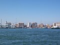 Port Said coastline
 -
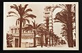
 The unique type of houses in Port Said making use of Arches
 -
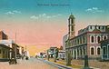 Port Said (postcard around 1915)
 -
 Modern Port Said at night
 -
 Tourist jetty in Port Said
 -
 Monument of Lesseps
 -
 Mosque in Port Said
 -
 Building of Suez Canal Authority in Port Said
 -
 The commerce street
 -
 The Latin Cathedral in Port Said built in 1934


_-_front_-_TIMEA.jpg)

_-_front_-_TIMEA.jpg)
_-_front_-_TIMEA.jpg)
_-_front_-_TIMEA.jpg)
Education
Colleges and universities
Port Said has a number of higher education institutions. Port Said University is a public university that follows the Egyptian system of higher education. The most notable faculties of the university are the faculty of engineering and the faculty of science. In addition, the Arab Academy for Science and Technology and Maritime Transport is a semi-private educational institution that offers courses for high school, undergraduate level students, postgraduate. It is considered the most reputable university in Egypt after the AUC American University in Cairo because of its worldwide recognition from (board of engineers at UK & ABET in USA). Sadat Academy for Management Sciences is an Egyptian Public Academy under the authorization of the Ministry of State for Administrative Development.
Schools
Port Said contains about 349 schools in all different educational stages between governmental, experimental, private language schools beside French historical schools.
Transport
Airports
Port Said is served by Port Said Airport located about 6 km (3.7 mi) away from city centre.
The airport reopened in February 2011 after being modernised to be fit for international flights.[7]
Highways
- The International coastal road. (Alexandria - Port Said)
- Cairo – Ismailia - Port Said desert road.(Port Said - Cairo /200 km)
- Port Said - Damietta road.
Train
The Port Said train station is on Mustafa Kamal Street, There are frequent train services from Cairo, Alexandria and other main Egyptian cities to Port Said. The travel time between Cairo and Port Said is about four hours while the Alexandria - Port Said route can be covered in about six hours. Intercity passenger service is operated by Egyptian National Railways. Tickets can be reserved online using the Egyptian National Railways website.[8]
Ferry

Port Said is linked by the Ferry to its twin city Port Fouad which is considered the Asian part of this Afro-Asian governorate "Port Said" on the eastern bank of the Suez Canal, the ferry is used to cross the Canal between the two cities holding both people and cars as well for free, the time between the two cities across the canal by using the ferry doesn't exceed 10 minutes.
Other means of public transport
Public buses are operated by Port Said Governorate's Agency for Public Passenger Transport. Private Transport also are available referred to as Micro Buses (14 seat minibus).Saloon car Taxicabs are comfort white and blue with reasonable price.
Port
The Port of Port Said is the 28th-busiest seaport for container transport, the second-busiest in the Arab world (narrowly behind the port of Salalah in Oman), and the busiest container seaport in Egypt, with 3,470 TEU transported in 2009.[9] It is divided into:
- Port Said Port
- East Port Said Port
The port is bordered, seaward, by an imaginary line from the western breakwater boundary till the eastern breakwater end. And from the Suez Canal area, it is bordered by an imaginary line extending transversely from the southern bank of the Canal connected to Manzala Lake, and the railways arcade livestock.
Navigation channels
- Main channel
- Length: 8 km (5 mi)
- Depth: 13.72 m (45.01 ft)
- East verge channel
- Length: 19.5 km (12 mi)
- Depth: 18.29 m (60.01 ft)
Approach area

Two breakwaters protect the port entrance channel: the western breakwater is about 3.5 miles (5.6 km) long, and the eastern breakwater is approximately 1.5 miles (2.4 km).
Dwelling area
The Suez Canal dwelling area is situated between latitudes 31° 21' N and 31° 25' N and longitudes 32° 16.2°' E and 32° 20.6' E. where vessels awaiting to accede Port Said port stay whether to join the North convoy to transit the Suez Canal to carry out stevedoring operations or to be supplied with provisions and bunkers. The dwelling area is divided into two sections: The Northern Area is allocated for vessels with deep drafts. The Southern Area is for all vessel types.
Culture
Libraries
Misr Public Library in Port Said was inaugurated in 2004 near the beach to serve the people of the city. The total area of the library about 12,500 meters (41,000 ft) and it is surrounded by a garden and a cafeteria to serve the users. The library is divided into halls for children, adults, training center, a distinct hall for seminars and a hall for audio-visual materials. The library at the time of its inauguration reached about 14,000 books and was supplied by encyclopedias and modern references.[10]
Museums
- Port Said National Museum, It is located in Palestine street in front of the tourist jetty, near the centre of the city. It contains about 9000 artifacts that narrate the story of Port Said and Egypt.
- Port Said Military Museum was inaugurated in 1964.It is located in 23 July street, It narrates the story of the Egyptian resistance in Port Said for the tripartite aggression during the Suez Crisis in 1956, the wars of 1967 and 1973, also It contains a hall that narrates the genesis of the city and the Suez Canal.
- Museum of Modern Art in Egypt.
Sports
The main sport that interests Port Saidians is football, as is the case in the rest of Egypt and Africa, meanwhile Port Saidians are known by their enthusiasm in supporting their popular team Al-Masry Club.
Port Said Stadium is a multi-purpose stadium in Port Said, Egypt. It is currently used mostly for football matches, and was used for the 1997 FIFA U-17 World Championship, 2006 African Cup of Nations, 2009 FIFA U-20 World Cup held in Egypt. The stadium was built in 1954. It holds 17,988 people.[11]
The second most popular sport in Port Said is Handball, the city has a club called Port Said Club that won many local and African tournaments during the nineties.
Port Said Hall is an Indoor Hall in Port Said that hosts competitions of Handball, Basketball and Volleyball, and was used for the 1999 World Men's Handball Championship held in Egypt. It holds 5000 people.
Hockey and other sports are practiced on a lower scale.
Tourism

Port Said is a main summer resort and tourist attraction, due to its public and private beaches, cosmopolitan heritage, Museums and duty-free port, beside the other landmarks like the Lighthouse of Port Said, the war memorial that has shape of the Pharaonic ancient obelisks and the building of the Suez Canal Authority headquarter in Port Said, also Tennis, Egypt island situated in lake Manzaleh is a destination that attracts tourists to enjoy visiting this ancient Islamic city which was demolished during the crusades.
Notable natives
- Abdulrahman Fawzi, (former Egyptian player in Al-Masry, participated in the World Cup 1934)
- Abdel Rahman Shokry, (Egyptian poet)
- Amr Diab, (Egyptian singer and composer and best-selling Arab recording artist)
- El-Sayed El-Dhizui, (former Egyptian player in Al-Masry and one of the top scorers in the Egyptian Premier League)
- Fayza Aboel Naga, (Egyptian minister of international cooperation)
- Hani Abou Raida, (FIFA executive member)
- Hans Dijkstal, (Dutch politician "former Deputy Prime Minister")
- Ibrahim El Batout, (Egyptian director)
- Mahmoud Yassin, (Egyptian actor)
- Malak Algamal, (Egyptian actress)
- Mohamed Sayed Said, (Egyptian journalist and political analyst)
- Mohamed Shawky, (professional football player with Al-Ahly)
- Mohamed Zidan, (professional football player with Borussia Dortmund)
- Mohsen Sarhan, (Egyptian actor)
- Mosaad Nour, (former Egyptian player in Al-Masry Club "the historic star of the team")
- Nagea Abou-El-Nour El-Qeaa
- Samir Farag, (former Luxor governor)
- Sekina Fouad, (Egyptian journalist and novelist)
- Suheir Ramzi, (Egyptian actress)
- Ibrahim Soudan
International relations
Twin towns — sister cities
Port Said is twinned with:
See also
References
- ^ http://www.portsaid.gov.eg/magals/ascan/Lists/List8/DispForm.aspx?ID=1
- ^ http://www.rosaonline.net/Daily/News.asp?id=36636
- ^ http://www.portsaid.gov.eg/tourism/default.aspx
- ^ a b Port-Saïd : Architectures XIXe-XXe siècles
- ^ http://www.myportsaid.info/Brief%20History%20of%20 PS.html
- ^ "Port Said/El Gamil, Egypt: Climate, Global Warming, and Daylight Charts and Data". Climate Charts. Retrieved September 11, 2009.
- ^ http://english.ahram.org.eg/NewsContent/3/12/738/Business/Economy/Port-Said-Airport-to-be-inaugurated-in-February.aspx
- ^ http://www.portsaid-shoreexcursions.com/port-said-transportation
- ^ Port of Hamburg: Container port throughput in a global comparison
- ^ http://www.mpl.org.eg/arabic/history-intro.htm
- ^ http://www.almasryclub.com/topic.php?post=134
External links
- Port Said Governorate Official website (in Arabic)
- Template:Wikitravel
- Port Said Page on Facebook
- History of Port Said 1859-1939 (in English)
- Port Said Port Authority
- Portsaid's Free-zone
- Portsaid history
- Portsaid-online (in Arabic)
31°16′N 32°17′E / 31.26°N 32.29°E
| Authorities |  | ||||||
|---|---|---|---|---|---|---|---|
| Cities and ports | |||||||
| Infrastructure |
| ||||||
| Marine life | |||||||
| History |
| ||||||