
Utah
| ||||||||||||||||||||||||||||||||||||
|
| ||||||||||||||||||||||||||||||||||||
Utah (IPA: ˈjutɑː) is a U.S. state located in the western United States. It was the 45th state admitted to the union on January 4, 1896. Approximately 80% of Utah's 2,500,000 people live in a population corridor centered on Salt Lake City, known as the Wasatch Front. In contrast, vast expanses of the state are relatively uninhabited and rural, making Utah the sixth most urbanized state.[1]
The state is generally rocky with three distinct geological regions: the Rocky Mountains, the Great Basin, and the Colorado Plateau. Utah is known for its natural diversity and is home to features ranging from arid deserts with sand dunes to thriving pine forests in mountain valleys.
It has a large tourism business and was host to the 2002 Winter Olympics. The ski resorts in the northern Wasatch Range, the Bonneville Salt Flats, the Great Salt Lake, the five national parks in the south, such as Arches, Zion and Bryce Canyon, and cultural attractions such as Temple Square and the Sundance Film Festival, are among the most visited.
Approximately 60% of state residents are adherents of the Church of Jesus Christ of Latter-day Saints (LDS Church), which represent less than 50% of the population in urban areas and over 90% in rural areas [citation needed]. The religion has historically had a strong regional influence and has contributed the state's restrictive attitude towards alcohol and gambling, while also contributing to its high birth rate (by far the highest in the nation). Before 1890, the Church's teachings of polygamy had led to confrontation with the U.S. federal government in the Utah War.
Beginning in the late 19th century with the state's mining boom, including what is now the world's largest open pit mine, companies attracted large numbers of immigrants (of diverse faiths) with job opportunities. The new immigrants often found themselves at odds with the state's LDS population. As a result, these tensions have played a large part in Utah's history (Liberal Party vs. People's Party) and continue to do so as the state further diversifies.
Geography
Utah is one of the Four Corners states, and is bordered by Idaho and Wyoming in the north; by Colorado in the east; at a single point by New Mexico to the southeast (at the Four Corners Monument); by Arizona in the south; and by Nevada in the west. It covers an area of 84,899 square miles (219,887 km²).
One of Utah's defining characteristics is the variety of its terrain. Running down the center of the state is the Wasatch Range, which rises to heights of about 12,000 feet (3,650 m) above sea level. Portions of these mountains receive more than 500 inches (1,250 cm) of snow each year and are home to world-renowned ski resorts, made popular by the light, fluffy snow, which is considered good for skiing. In the northeastern section of the state, running east to west, are the Uinta Mountains, which rise to heights of 13,000 feet (3,950 m) or more. The highest point in the state, Kings Peak, at an elevation of 13,526 feet (4,123 m), lies within the Uinta Mountains.
At the western base of the Wasatch Range is the Wasatch Front, a series of valleys and basins that are home to the most populous parts of the state. The major cities of Ogden, Salt Lake City, Layton, West Valley City, Sandy, West Jordan, Orem, and Provo are located within this region, which stretches approximately from Brigham City at the north end to Nephi at the south end. Approximately 75% of the population of the state lies in this corridor, and urban sprawl continues to expand along the edges of these valleys.

Western Utah is mostly arid desert with a basin and range geology. Small mountain ranges and rugged terrain punctuate the landscape. However, the Bonneville Salt Flats are an exception, being comparatively flat. Most of western Utah was once covered in Lake Bonneville. The Great Salt Lake and Utah Lake are the only two significant remains of this ancient freshwater lake, which once covered most of the eastern Great Basin. West of the Great Salt Lake, stretching to the Nevada border, lies the Great Salt Lake Desert, the most arid area in Utah.
Much of the scenic southern landscape is sandstone, more specifically Kayenta sandstone and Navajo sandstone. The Colorado River and its tributaries wind their way through the sandstone, creating some of the most striking and wild terrain in the world. Wind and rain have also sculpted the soft sandstone over millions of years. Canyons, gullies, arches, pinnacles, buttes, bluffs, and mesas are the common sight throughout south-central and southeast Utah. This terrain is accentuated in protected parks such as Arches, Bryce Canyon, Canyonlands, Capitol Reef, and Zion national parks, Cedar Breaks, Grand Staircase-Escalante, Hovenweep, and Natural Bridges national monuments, Glen Canyon National Recreation Area (site of the popular tourist destination, Lake Powell), Dead Horse Point and Goblin Valley state parks, and Monument Valley, a popular photographic and filming site.


Southwestern Utah is the lowest and hottest spot in Utah. It is known as Dixie because early settlers were able to grow limited amounts of cotton there. Beaverdam Wash in far southwestern Utah is the lowest point in the state, at an elevation of 2,000 feet (610 m). The northernmost portion of the Mojave Desert is also located in this area. Dixie is quickly becoming a popular recreational and retirement destination, and the population is growing rapidly. Just north of Dixie is the state's highest ski resort, Brian Head.
Eastern Utah is a high elevation area covered mostly by plateaus and basins. Economies are dominated by mining, oil and natural gas-drilling, ranching, and recreation. Much of eastern Utah is part of the Uintah and Ouray Indian Reservation. The most popular destination within eastern Utah is Dinosaur National Monument.
Like most of the west and southwest states, the federal government owns much of the land in Utah. Over seventy percent of the land is either BLM land or U.S. National Forest, park, U.S. National Monument, National Recreation Area or U.S. Wilderness Area.
Climate
Most of Utah is arid and high in elevation. Most of eastern and southern Utah receive 12 inches (300 mm) or less of precipitation per year, while many mountain areas receive more than 40 inches (1,000 mm) per year, with some areas receiving up to 60 in (1,500 mm). Much of western Utah receives less than 10 inches (250 mm), while the Wasatch Front receives approximately 15 inches (380 mm). The Great Salt Lake Desert is especially dry, receiving less than 5 inches (130 mm) annually. Snowfall is common in winter everywhere except the southern border and the Great Salt Lake Desert. St. George averages about 3 inches (7.5 cm) of snow per year, while Salt Lake City receives almost 60 inches (150 cm) annually (amplified by the lake effect from the Great Salt Lake). Many mountain areas receive in excess of 350 inches (900 cm) of snow in a year, while portions of the Wasatch Range receive up to 500 inches (1,250 cm). Snowfall is common from late November through March in the lower elevations and from October through May in the mountains. The mountains often remain snow-covered into July. Fog and haze often caused by temperature inversions are common in the valleys and basins during winter, especially the Uinta Basin, just south of the Uinta Mountains.
During summer and fall, most of the precipitation is received from the storms coming from the south and consists of short, sporadic, and intense thunderstorms that can cause wildfires and flash floods. Most precipitation during the rest of the year is received from the Pacific Ocean. Spring is the wettest season across the north while late summer and early fall are the wettest times in the south and winter is the wettest season in most of the mountain areas.
Temperatures during the winter across much of Utah are below freezing. High temperatures average between 25 °F (-4 °C) and 50 °F (10 °C) across the state. Days below 0 °F (-18 °C) can be expected in many areas at least once a year, but they are usually short in duration and not terribly severe. Mountains to the north and east of the state serve as barriers to Arctic air. In the summer, high temperatures average between 85 °F (29 °C) and 100 °F (38 °C). Days over 100 °F (38 °C) can be expected in most areas below 5,000 feet (1,500 m) at least once per year and are the norm in the southern valleys. The record high temperature in Utah was 117 °F (47 °C), recorded at St. George on July 5, 1985, and the record low was -69 °F (-56 °C), recorded at Peter's Sink in the Bear River Mountains of northern Utah on February 1, 1985.
History
Early history


Native Americans have lived in what is now Utah for several thousand years; most archeological evidence dates such habitation about 10,000 to 12,000 years ago. Some left petroglyphs and pictographs which exist throughout the state.
Francisco Vásquez de Coronado may have crossed into what is now southern Utah in 1540, when he was seeking the legendary Cíbola.
A group led by two Catholic priests—sometimes called the Dominguez-Escalante Expedition—left Santa Fe in 1776, hoping to find a route to the California coast. The expedition traveled as far north as Utah Lake and encountered the native residents.
Fur trappers—including Jim Bridger—explored some regions of Utah in the early 1800s. The city of Provo was named for one such man, Étienne Provost, who visited the area in 1825.
Mormon settlement
Mormon pioneers first came to the Salt Lake Valley on July 24, 1847. At the time, Utah was still Mexican territory. As a consequence of the Mexican-American War, the land became the territory of the United States upon the signing of the Treaty of Guadalupe Hidalgo, February 2, 1848. The treaty was ratified by the United States Senate on March 10. In 1850, the Utah Territory was created with the Compromise of 1850, and Fillmore was designated the capital. In 1856, Salt Lake City replaced Fillmore as the territorial capital.
Disputes between the Mormon inhabitants and the US Government intensified after The Church of Jesus Christ of Latter-day Saints admitted to the practice of polygamy among their members. The Mormons were pushing for the establishment of the State of Deseret. The U.S. Government, which was reluctant to admit a state the size of the proposed Deseret into the union, opposed the polygamous practices of the Mormons.
After news of their polygamous practices spread, the members of the LDS Church were quickly viewed as un-American and rebellious. In 1857, after news of a false rebellion spread, the government sent troops on the "Utah expedition" to quell the supposed rebellion and to replace Brigham Young as territorial governor with Alfred Cumming. The resulting conflict is known as the Utah War.
As troops approached Salt Lake in northern Utah, nervous Mormon settlers and Paiutes attacked and killed 120 immigrants from Arkansas in southern Utah. The attack became known as the Mountain Meadows Massacre. The massacre became a point of contention between LDS leaders and the federal government for decades. Only one man, John D. Lee, was ever convicted of the murders, and he was executed at the massacre site.
Before troops led by Albert Sidney Johnston entered the territory, Brigham Young ordered all residents of Salt Lake City to evacuate southward to Utah Valley and sent out a force, known as the Nauvoo Legion, to delay the government's advance. Although wagons and supplies were burned, eventually the troops arrived, and Young surrendered official control to Cumming, although most subsequent commentators claim that Young retained true power in the territory. A steady stream of governors appointed by the president quit the position, often citing the unresponsiveness of their supposed territorial government. By agreement with Young, Johnston established Fort Floyd 40 miles away from Salt Lake City, to the southwest.
Salt Lake City was the last link of the transcontinental telegraph, completed in October of 1861. Brigham Young was among the first to send a message, along with Abraham Lincoln and other officials.

Because of the American Civil War, federal troops were pulled out of Utah Territory, leaving the territory in LDS hands until Patrick E. Connor arrived with a regiment of California volunteers in 1862. Connor established Fort Douglas just three miles (5 km) east of Salt Lake City and encouraged his men to discover mineral deposits to bring more non-Mormons into the state. Minerals were discovered in Tooele County, and miners began to flock to the territory.
Beginning in 1865, Utah's Black Hawk War developed into the deadliest conflict in the territory's history. Chief Antonguer Black Hawk died from tuberculosis and syphilis in 1870, but fights continued to break out until additional federal troops were sent in to suppress the Ghost Dance of 1872. The war is unique among Indian Wars because it was a three-way conflict, with mounted Timpanogos Utes led by Antonguer Black Hawk exploited by federal and LDS authorities.
On May 10, 1869, the First Transcontinental Railroad was completed at Promontory Summit, north of the Great Salt Lake. The railroad brought increasing numbers of people into the state, and several influential businessmen made fortunes in the territory.
During the 1870s and 1880s, laws were passed to punish polygamists, and in the 1890 Manifesto, the LDS Church finally agreed to ban polygamy. When Utah applied for statehood again, it was accepted. One of the conditions for granting Utah statehood was that a ban on polygamy be written into the state constitution. This was a condition required of other western states that were admitted into the Union later. Statehood was officially granted on January 4, 1896.
20th century

Beginning in the early 1900s, with the establishment of such national parks as Bryce Canyon National Park and Zion National Park, Utah began to become known for its natural beauty. Southern Utah became a popular filming spot for arid, rugged scenes, and such natural landmarks as Delicate Arch and "the Mittens" of Monument Valley are instantly recognizable to most national residents. During the 1950s, '60s, and '70s, with the construction of the Interstate highway system, accessibility to the southern scenic areas was made easier.
Beginning in 1939, with the establishment of Alta Ski Area, Utah has become world-renowned for its skiing. The dry, powdery snow of the Wasatch Range is considered some of the best skiing in the world. Salt Lake City won the bid for the 2002 Winter Olympics in 1995, and this has served as a great boost to the economy. The ski resorts have increased in popularity, and many of the Olympic venues scattered across the Wasatch Front continue to be used for sporting events. This also spurred the development of the light-rail system in the Salt Lake Valley, known as TRAX, and the re-construction of the freeway system around the city.
During the late 20th century, the state grew quickly. In the 1970s, growth was phenomenal in the suburbs. Sandy was one of the fastest-growing cities in the country at that time. Today, many areas of Utah are seeing phenomenal growth. Northern Davis, southern and western Salt Lake, Summit, eastern Tooele, Utah, Wasatch, and Washington counties are all growing very quickly. Transportation and urbanization are major issues in politics as development consumes agricultural land and wilderness areas.
Demographics
| Historical populations | |
|---|---|
| Census year |
Population |
| 1850 | 11,380 |
| 1860 | 40,273 |
| 1870 | 86,336 |
| 1880 | 143,963 |
| 1890 | 210,779 |
| 1900 | 276,749 |
| 1910 | 373,351 |
| 1920 | 449,396 |
| 1930 | 507,847 |
| 1940 | 550,310 |
| 1950 | 688,862 |
| 1960 | 890,627 |
| 1970 | 1,059,273 |
| 1980 | 1,461,037 |
| 1990 | 1,722,850 |
| 2000 | 2,233,169 |
As of 2005, Utah has an estimated population of 2,469,585, which is an increase of 48,877, or 2.0%, from the prior year and an increase of 236,387, or 10.6%, since the year 2000. This includes a natural increase since the last census of 186,411 people (that is 254,433 births minus 68,022 deaths) and an increase due to net migration of 16,173 people into the state. Immigration from outside the United States resulted in a net increase of 49,995 people, and migration within the country produced a net loss of 33,822 people.
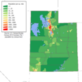
Much of the population lives in cities and towns along the Wasatch Front, a metropolitan region that runs north-south with the Wasatch Mountains rising on the eastern side. The rest of the state is mostly rural or wilderness. Utah has a higher percentage of people sharing a single religious denomination than any other state.
Utah contains 5 metropolitan areas (Logan, Ogden-Clearfield, Salt Lake City, Provo-Orem, and St. George), and 5 micropolitan areas (Brigham City, Heber, Vernal, Price, and Cedar City). The St. George metropolitan area is currently the second-fastest growing in the country (behind Las Vegas), while the Heber micropolitan area is also the second-fastest growing in the country (behind Palm Coast, Florida). [1]
-
 Population Density Map
 -
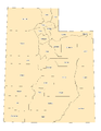 County boundaries


Race and ancestry
The racial makeup of Utah is:
- 85.3% White American non-Hispanic
- 9.0% Hispanic
- 1.7% Asian
- 1.3% Native American
- 0.8% Black
- 0.7% Pacific Islander American
- 2.1% Mixed race
The five largest ancestry groups in the state are:
- 29.0% English
- 11.6% German
- 6.8% Native American
- 6.5% Danish
- 6.1% Mexican
Most Utahns are of Northern European descent. The state has the largest percentage of residents who claim British ancestry and the largest percentage of residents of Danish ancestry in the nation. Anglo-Utahns are the largest group in every county except for San Juan County, which has a large Navajo Indian population. Hispanics are the fastest growing ethnic group (at an increase of 138.3%; 67.7% of which are Mexican) in Utah. The fastest growing race is the Asian-Pacific Islander category, which increased 56.6%, with Chinese forming the largest Asian group and Tongans forming the largest Pacific Islander group.
Religion

Utah is well-known for being a heavily Mormon (or Latter Day Saint) state. This means that a majority of the state's residents are affiliated with The Church of Jesus Christ of Latter-day Saints (or LDS Church) or one of its schisms such as the Fundamentalist Church of Jesus Christ of Latter Day Saints and other Latter Day Saint denominations. These smaller denominations do not derive their authority from the modern LDS religion. There are Catholics, Protestants, and Jews present in the state as well, but their numbers are relatively small. However, the Salt Lake Tribune has projected that Latter-day Saints might become a minority as early as 2030[citation needed].
The religious affiliations of the people of Utah are:
- Christian - 75%
- Latter-Day Saint - 57%
- Roman Catholic - 6%
- Episcopalian - 3%
- Baptist - 2%
- Other Christian - 3%
- Evangelical - 1%
- Presbyterian - 1%
- Lutheran - 1%
- Methodist - 1%
- No religion - 17%
- Refused to identify - 4%
- Other Religions - 3%
- Muslim - 1%
Totals are rounded. Pentecostal, Judaism, Church of Christ, Non-denominational, United Church of Christ, Jehovah's Witness, Assemblies of God, Buddhist, Church of God, and Seventh Day Adventist, represent less than .5% of the population. [2]
Age and sex
Due to its high total fertility rate (highest of any state in the U.S.), Utah has the youngest population of any state.
The age distribution in Utah is:
- 9.4% under age 5
- 32.2% under age 18
- 8.5% 65 or older
The gender makeup of Utah is:
- 49.9% female
- 50.1% male
Economy
According to the U.S. Bureau of Economic Analysis, the gross state product of Utah in 2004 was $82.6 billion. The per capita personal income was $26,606 in 2004.
Major industries of Utah include: mining, cattle ranching, salt production, and government services.
Utah collects personal income tax within 6 income brackets, ranging from 2.3% to 7.0%. The state sales tax rate is 4.75%. Cities and counties levy additional local sales taxes that vary among the municipalities. Property taxes are assessed and collected locally. Utah does not charge intangible property taxes and does not impose an inheritance tax.
Transportation
Interstate 15 is the main interstate highway in the state, entering from Arizona north to Idaho and serving such cities as St. George, Provo, Salt Lake City, and Ogden. Interstate 84 enters from Idaho at Snowville and merges with I-15 at Tremonton, staying merged until Roy. I-84 then heads southeast through the mountains, terminating at Interstate 80 at Echo. I-80 enters Nevada at Wendover and heads east through Salt Lake City, briefly merging with I-15 before climbing into the mountains and weaving through canyons and across plateaus into Wyoming, just before reaching Evanston. Interstate 70 begins at Cove Fort and heads east through mostly uninhabited areas, providing access to many of southern Utah's recreation areas before entering Colorado. The stretch of I-70 between Salina and Green River is the longest stretch of interstate in the nation without any services.
A light rail system in the Salt Lake Valley known as TRAX consists of two lines, one providing access from downtown Salt Lake City and Sandy, and the other providing access to the University of Utah east of downtown. The Utah Transit Authority (UTA) operates a bus system stretching across the Wasatch Front and into Tooele, and also provides winter service to the ski resorts above Salt Lake City. Several bus companies provide access to the ski resorts in winter, and local bus services also serve Logan, St. George and Cedar City. The Legacy Highway is a controversial freeway that is planned to eventually run down the entire length of the Wasatch Front. The first portion, known as the Legacy Parkway, in southern Davis County, will begin construction in spring 2006. A commuter rail line, named FrontRunner, is under construction between Salt Lake City and Pleasant View, north of Ogden, and will be complete by 2008. FrontRunner is expected to eventually span the Wasatch Front from Brigham City in the north to Payson in the south.
Law and government
Utah government, like most U.S. states, is divided into three branches: executive, legislative, and judicial. The current governor of Utah is Jon Huntsman, Jr.
Constitution
The constitution of Utah was enacted in 1895. Notably, the constitution outlawed polygamy and continued the territorial practice of women's suffrage.
Amendments
Utah's Constitution has been amended many times since its inception.[3] Three recent amendments were put on the Utah election ballot: Amendment 1 would allow the state legislature to convene special sessions to impeach authority; Amendment 2 would allow state or public institutions of higher learning to acquire ownership interest in private businesses in exchange for intellectual property rights that are developed by those institutions; and Amendment 3 defined marriage as a civil union between one man and one woman and provided no legal recognition for other forms of civil unions.
All three amendments passed and went into effect on January 1, 2005. On the question of Amendment 3 (which defined marriage as between one man and one woman), 54% of Salt Lake County voters favored it while 82% of their Utah County counterparts were in favor.
Utah is also one of only two states in the United States to outlaw all forms of gambling; the other is Hawaii.
Utah is an Alcoholic beverage control state. Wine and spiritous liquors may only be purchased at state liquor stores, and local laws prohibit the sale of beer and other alcoholic beverages on Sundays.
Politics

Despite its political neutrality, the influence of the Church of Jesus Christ of Latter-day Saints has made Utah one of the most Republican states in the nation. However, the brand of Republicanism is more libertarian than most. See amendments
The state's leadership is run by the Republican Party. State governors are usually centrist on social issues and favor free trade on economic policies, while the state senate and house are much more polarized with Republican members passing very socially conservative policies on party-line and partisan votes. Many of these bills have been subsequently vetoed by the governors.
While the people of the state are generally more tolerant of gay rights and polls indicate that a majority of residents support some form of legal recognition for same-sex couples, the state legislature is markedly more hostile. About 90% of elected officials in the Utah Legislature are members of the Church of Jesus Christ of Latter-day Saints, while they only account for 60% of the population.
In 2005 the Utah state legislature refused to pass a hate crimes bill that included protections to gays and lesbians, despite support from 66% of Utah voters and the LDS Church. A year later in 2006 the legislature passed legislation aimed at banning joint-custody for a non-biological parent of a child. The custody measure passed the legislature and was vetoed by the governor, a reciprocal benefits supporter.
Prayers are commonplace in Utah politics, and lawmakers of both parties, whether liberal or conservative, speak of their relationship with God or their religious beliefs in ordinary conversation.
Utah's liberal areas include Carbon County, Grand County, Salt Lake County, and Summit County. Currently, both Salt Lake City and Salt Lake County have Democratic Party mayors and are home to about one million of the state's two and a half million residents. Salt Lake City's Mayor Rocky Anderson is known for his support of same-sex marriage and the Kyoto Treaty, while the county mayor Peter Corroon is a relative of Howard Dean and shares similar views. The city itself has not voted for a Republican mayor since the 1970s. Salt Lake County's Democrats tend to favor the economic policies of free trade while being socially liberal, particularly with gay rights and less so with abortion.
Carbon County's Democrats are generally made up of members of the large Greek community, whose ancestors migrated in the early 1900s to work in the extensive mining industry. The views common amongst this group are heavily influenced by labor politics and large unions with centrist to conservative social ideals.
Grand County's politics are heavy on environmentalism and being socially liberal. The county has a large hippie community situated in the resort town of Moab in red rock country between Arches National Park and Canyonlands National Park.
The Democrats of Summit County are the by-product of the migration of wealthy families from California in the 1990s to the ski resort town of Park City; their views are generally supportive of the economic policies favored by unions and the social policies favored by the liberals.
The state's most Republican areas tend to be Utah County, which is the home to Brigham Young University and Provo, and nearly all the rural counties. The Republicans found in these areas generally hold socially conservative views in line with that of the national Religious Right; these views nearly always take precedence over any economic beliefs.
The state has not voted for a Democrat for president since 1964. Historically, Republican presidential nominees score one of their best margins of victory here. Utah was the Republicans' best state in the 1976, 1980, 1984, 1988, 1996 and 2004 elections. In 2004, Republican George W. Bush won every county in the state and Utah gave him his largest margin of victory of any state. He won the state's 5 electoral votes by a margin of 46 percentage points with 71.5% of the vote. Utah's Democrats publicly expressed displeasure with the selection of John Kerry after the election, whom they found to be too friendly to abortion and the labor unions, and too hostile to gay-rights and free trade for their constituents' taste. In the 1996 Presidential elections the Republican candidate received a smaller 54% of the vote while the Democrat earned 34%. [4]
Important cities and towns


Lists of cities in Utah: Alphabetical—Ranked by population
Utah's population is concentrated in two areas, the Wasatch Front in the north-central part of the state, with a population of approximately 2 million; and southwestern Utah, locally known as "Dixie", with nearly 150,000 residents.
According the 2000 Census, Utah was the fourth fastest growing state (at 29.6%) in the United States between 1990 and 2000. St. George, in the southwest, is the second-fastest growing metropolitan area in the United States, trailing Las Vegas, Nevada.
The state's two fastest growing counties are: Summit (at 91.6%; ranking it 8th in the country) and Washington (at 86.1%; ranking it 12th). The cities (defined as having at least 9,000 residents in 2000) that saw the greatest increases between 1990 and 2000 were: Draper (248%), South Jordan (141%), Lehi (125%), Riverton (122%), and Syracuse (102%). Between 1990 and 2000 the five fastest-growing cities of any size were Cedar Hills (302%), Draper (248%), Woodland Hills (213%), Ivins (173%), and South Jordan (141%). According to U.S. Census Bureau estimates, the five fastest-growing cities of any size between 2000 and 2004 were Saratoga Springs (437%), Herriman (414%), Eagle Mountain (280%), Cedar Hills (88%), and Syracuse (72%).
| Utah Rank |
City | Population (2005) within city limits |
Land Area sq. miles |
Population Density per sq mi |
County |
|---|---|---|---|---|---|
| 1 | Salt Lake City | 178,097 | 109.1 | 1,632.4 | Salt Lake |
| 2 | Provo | 113,459 | 39.6 | 2,865.1 | Utah |
| 3 | West Valley City | 113,300 | 35.4 | 3,200.5 | Salt Lake |
| 4 | West Jordan | 91,444 | 30.9 | 2,959.3 | Salt Lake |
| 5 | Orem | 89,713 | 18.4 | 4,875.7 | Utah |
| 6 | Sandy | 89,664 | 22.3 | 4,020.8 | Salt Lake |
| 7 | Ogden | 78,309 | 26.6 | 2,943.9 | Weber |
| 8 | St. George | 64,201 | 64.4 | 996.9 | Washington |
| 9 | Layton | 61,782 | 20.7 | 2,984.6 | Davis |
| 10 | Taylorsville | 58,009 | 10.7 | 5,421.4 | Salt Lake |
| Combined Statistical Area | Population (2004) |
|---|---|
| Salt Lake City-Ogden-Clearfield comprised of: Salt Lake City and Ogden-Clearfield Metropolitan Areas and Brigham City and Heber Micropolitan Areas (as listed below) |
1,559,230 |
| Utah Rank |
Metropolitan Area | Population (2004) |
U.S. Rank |
|---|---|---|---|
| 1 | Salt Lake City* | 1,018,826 | 50 |
| 2 | Ogden-Clearfield* | 477,455 | 101 |
| 3 | Provo Orem | 412,361 | 112 |
| 4 | St. George | 109,924 | 318 |
| 5 | Logan | 109,666 | 320 |
* Until 2003, the Salt Lake City and Ogden-Clearfield metropolitan areas were considered as a single metropolitan area.[2]
| Utah Rank |
Micropolitan Area | Population (2004) |
U.S. Rank |
|---|---|---|---|
| 1 | Brigham City | 44,810 | 280 |
| 2 | Cedar City | 36,285 | 386 |
| 3 | Vernal | 26,671 | 495 |
| 4 | Price | 19,689 | 550 |
| 5 | Heber | 18,139 | 560 |
See also Utah locations by per capita income
Education
Colleges and universities
|
|
Professional sports teams

The Utah Jazz of the National Basketball Association play in the Delta Center in Salt Lake City. Utah is by far the least populous U.S. state to have a major professional sports league franchise, although the District of Columbia has fewer people. Other teams include:
- Real Salt Lake of Major League Soccer in Rice-Eccles Stadium in Salt Lake City (a soccer-specific stadium has been approved for Sandy, but funding deals for the stadium have been struck down and the status for the stadium is uncertain)
- Salt Lake Bees of the Pacific Coast League in Franklin Covey Field in Salt Lake City
- Ogden Raptors of the Pioneer League in Lindquist Field in Ogden
- Orem Owlz of the Pioneer League in Parkway Crossings in Orem
- Utah Grizzlies of the ECHL in the E Center in West Valley City
- Utah Blaze of the Arena Football League at the Delta Center in Salt Lake City
Miscellaneous topics

- Popular recreational destinations within the mountains besides the ski resorts include Flaming Gorge National Recreation Area, Timpanogos Cave National Monument, Bear Lake, and Jordanelle, Strawberry, East Canyon, and Rockport reservoirs. The mountains are popular camping, rock-climbing, skiing, snowboarding, and hiking destinations.
- The trans-continental railroad was joined at Promontory Summit, Utah
- The 2002 Winter Olympics were hosted by Salt Lake City.
- The USS Utah was named in honor of this state.
- The Space Shuttle Solid Rocket Booster is built and serviced by the Thiokol division of ATK, which has its facilities in Brigham City. Boosters are tested periodically at a proving grounds in the Wasatch Range.
- Utah (as of 2002) ranks first in antidepressant use [5] and (as of 2005) no longer ranks first in personal bankruptcies per capita in the United States [6]. It ranks 47th in teen pregnancy (although at least some of these are married teenagers, which is not uncommon in the state), last in percentage of births out of wedlock, last in number of abortions per capita, and last in percentage of teen pregnancies terminated in abortion. Statistics relating to pregnancies and abortions may be artificially low from teenagers going out of state for abortions because of parental notification requirements [7], [8]. Utah has the lowest child poverty rate in the country, despite its young demographics [9].
- According to Internal Revenue Service tax returns, Utahns rank first among all U.S. states in the proportion of income given to charity by the wealthy [10].
- Jell-O is the official snack food of Utah [11].
- Mexican President Vicente Fox visited Salt Lake City, Utah, on May 23, 2006, as the first stop on his trip to the United States, which also included stops in California and Washington state. It is unusual for a foreign head of state to visit Utah (except for the 2002 Salt Lake City Olympics). However, the growing presence of Mexicans and Mexican Americans in Utah may be a reason for his visit. The Mormon church also has a large presence in Mexico. The Church claims to have approximately one million adherents in Mexico as of 2006.
Famous Utahns
- Philo Farnsworth - inventor of the electronic television.
- John Moses Browning - designer of popular firearms like the M2 .50 caliber machine gun and the Colt Model 1911 .45 semi-automatic handgun.
Branding
The state of Utah relies heavily on income from tourists and travelers taking advantage of the state's ski resorts and natural beauty, and thus the need to "brand" Utah and create an impression of the state throughout the world has led to several state slogans, the most famous of which being "The Greatest Snow on Earth," which has been in use in Utah officially since 1975 (although the slogan was in unofficial use as early as 1962) and now adorns nearly 50% of the state's license plates. In 2001, Utah Governor Mike Leavitt approved a new state slogan, "Utah! Where Ideas Connect," which lasted until March 10, 2006, when the Utah Travel Council and the office of Governor Jon Huntsman announced that "Life Elevated" would be the new state slogan.
See also
- List of bands from Utah
- Ballet West
- Mormon Miracle Pageant
- Mormon Tabernacle Choir
- Pioneer Theatre Company
- Ririe Woodbury Dance Company
- Salt Lake Acting Company
- Sundance Film Festival
- Tuacahn Summer Festival of Theater, which takes place in the Tuacahn Amphitheater in Padre Canyon adjacent to Snow Canyon State Park, near St. George
- Utah Ballet
- Utah Opera
- Utah Shakespearean Festival in Cedar City
- Utah Symphony Orchestra, which performs in Abravanel Hall in Salt Lake City
- Music of Utah
- Scouting in Utah
External links
 Definitions from Wiktionary
 Media from Commons
 News from Wikinews
 Quotations from Wikiquote
 Texts from Wikisource
 Textbooks from Wikibooks
 Resources from Wikiversity
- State of Utah official Web site
- Utah Office of Tourism
- Utah State Chamber of Commerce website
- U.S. Census Bureau
- Utah Media Directory
- Utah Newspapers
- Mountain Bike Trails in Utah
- Local Utah Music- Utah Out Loud
- Pictures of Utah
- Utah National Parks
- Photographic virtual tour of Utah.
- Photos of Utah - Terra Galleria
- UtahSearch.Com Useful & Interesting Utah Links Links to government, recreation, current news, city/county webs, schools, sex offenders, parks, statistics, phone book, etc.
- 2000 legislation establishes English as official language
- Court upholds English as official language
- Full text of the Utah state constitution
- Utah Dream's
- This Divided State Documentary about the controversy on Michael Moore speaking at Utah Valley College State
- Utah State Facts