
Mount Kaimon: Difference between revisions
No edit summary |
No edit summary |
||
| Line 25: | Line 25: | ||
}} |
}} |
||
{{Nihongo|'''Kaimondake'''|開聞岳|Kaimondake, Kaimon-dake}}, or '''Mount Kaimon''', is an undissected [[volcano]] – consisting of a basal stratovolcano and a small central volcano, part of the Ibusuki field – which rises to a height of 924 metres above sea level near the city of [[Ibusuki, Kagoshima|Ibusuki]] in southern [[Kyūshū]], [[Japan]]. The last eruption occurred in the year 885.Because |
{{Nihongo|'''Kaimondake'''|開聞岳|Kaimondake, Kaimon-dake}}, or '''Mount Kaimon''', is an undissected [[volcano]] – consisting of a basal stratovolcano and a small central volcano, part of the Ibusuki field – which rises to a height of 924 metres above sea level near the city of [[Ibusuki, Kagoshima|Ibusuki]] in southern [[Kyūshū]], [[Japan]]. The last eruption occurred in the year 885. Because of its conic shape, Mt. Kaimon is sometimes referred to as "the Fuji of [[Satsuma Province|Satsuma]]". |
||
== History == |
== History == |
||
Revision as of 14:37, 26 August 2022
| Kaimondake | |
|---|---|
| 開聞岳 | |
 | |
| Highest point | |
| Elevation | 924 m (3,031 ft) |
| Coordinates | 31°10′48″N 130°31′42″E / 31.18000°N 130.52833°E |
| Geography | |
| Geology | |
| Mountain type | stratovolcano |
| Last eruption | 885[1] |

Kaimondake (開聞岳, Kaimondake, Kaimon-dake), or Mount Kaimon, is an undissected volcano – consisting of a basal stratovolcano and a small central volcano, part of the Ibusuki field – which rises to a height of 924 metres above sea level near the city of Ibusuki in southern Kyūshū, Japan. The last eruption occurred in the year 885. Because of its conic shape, Mt. Kaimon is sometimes referred to as "the Fuji of Satsuma".
History
Mt. Kaimon began volcanic activity 4000 years ago. For 3,000 years up to 885 years, the big eruptions occurred 9 times and the eruption that a lot of magma was erupted occurred 10 times.
There is a sea scarp which is 7.8km wide and 9.3km long, the shape is similar to a horseshoe in the seabed at the southern foot of the mountain. There is a lot of sediment at the foot of the mountain due to submarine landslides. It was found that there is a sea scarp underground on the south side of the mountain and it was caused by pressure from a submarine landslide before Mt. Kaimon was formed.
The sedimentary layer of ejecta by the eruption at the end of the 7th century is called ao-kora (ao means blue and kora is soil consisting of volcanic ash found in the southern part of the Satsuma Peninsula), The sedimentary layer of ejecta by the eruption at the end of the 7th century is called murasaki-kora (Murasaki means purple). These layers are a clue to know the changes in life in this era. It has become clear that village was isolated by big eruption and change in life in the latter part of the 9th century.
Geography
Mt. Kaimon is important symbol of marine traffic because it is in the southernmost of Satsuma Peninsula which is located in the south of Kagoshima prefecture and forms Kinko Bay (Kagoshima Bay) with Ōsumi Peninsula, just the south of Kyushu. Together with Mt. Noma and Mt. Kinpo, it also forms part of the three mountains of Satsuma, which are also used by marine traffic.
Transition of height
In 1895, the height of Mt. Kaimon was 922.23 meters from a second triangulation point which is at the summit of the mountain but the official height was fixed 924 meters by Geospatial Information Authority of Japan in 2001, July because some climbers pointed out that the height of the rocks on the top of the mountain were higher than the triangulation point.[2]
-
 An aerial photograph of Kaimondake
 -
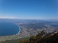
 Lake Ikeda (centre left) and Mount Kaimon (right)
 -
 As seen from a JR Ibusuki Makurazaki Line train
 -
 Lake Ikeda & Mt.Kaimon
 -
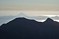 From Mt.Takakuma
 -
 From Jogasaki Observatory
 -
 From around Nagasakibana
 -
 Mt. Kaimon in early spring
 -
 The eighth station of Mt. Kaimon (“station” is unit of itinerary of climbing from the base to the top. Regardless mountain height, all itineraries are divided into 10.)
 -
 Ladder directly beneath the summit
 -
 The summit of Mt. Kaimon with Lake Ikeda in the background
 -
 Maehara coast and Lake Ikeda from the summit
 -
 Nagasakibana from the summit


Climbing
There is spiral-shaped hiking trail, and you can climb Mt. Kaimon in about 3 hours. Mt. Kaimon is considerably lower than most of the mountains on the 100 famous Japanese Mountains list but climbing starts from around sea level going up more than 900 meters. Mt. Kaimon is a single peak and near the summit rocky outcrops give views on all sides, such as Lake Ikeda to the north and the Pacific Ocean to the south.
Tourism
- Kaimon Sanroku Nature Park-There are Tokara horse at the base of the mountain. [3]
- Kaimon Sanroku Fureai Park- There are log houses, camp sites and so on. [4]
- Lake Ikeda- It is said that a mystery creature “Issie” live there. There are beautiful canola flowers in January. [5]
- Bohi Park-This is the park which console the people who were killed in the Pacific War in Philippines.
See also
References
- ^ "Ata: Eruptive History". Global Volcanism Program. Smithsonian Institution. Retrieved 2021-06-24.
- ^ 「開聞岳少しだけ高かった/新標高2メートル伸び924メートル=最高地点移動、登山者が指摘」南日本新聞2001年8月17日朝刊27面
- ^ https://www.ibusuki.or.jp/tourism/play/post-39/開聞山麓自然公園 | いぶすき観光ネット-Retrieved 2022-05-31
- ^ https://www.ibusuki.or.jp/tourism/play/kaimonpark/かいもん山麓ふれあい公園 | いぶすき観光ネット-Retrieved 2022-05-31
- ^ https://www.kagoshima-kankou.com/guide/10670池田湖 | 観光スポット | 【公式】鹿児島県観光サイト かごしまの旅-Retrieved 2022-05-31
External links
- Kaimondake - Japan Meteorological Agency (in Japanese)
- "Kaimondake: National catalogue of the active volcanoes in Japan" (PDF). - Japan Meteorological Agency
| Hokkaidō | |||||||||
|---|---|---|---|---|---|---|---|---|---|
| Tōhoku region Jōshinetsu region |
| ||||||||
| Kantō region | |||||||||
| Chūbu region |
| ||||||||
| Western Japan | |||||||||
| |||||||||
This Kagoshima Prefecture location article is a stub. You can help Wikipedia by expanding it. |