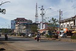
Steung Saen Municipality
Appearance
Steung Saen
ក្រុងស្ទឹងសែន | |
|---|---|
| Steung Saen Municipality | |
 | |
 | |
| Country | |
| Province | Kampong Thom |
| Time zone | +7 |
| Geocode | 0603 |
Steung Saen is a municipality, also a district within Kampong Thom Province, in central Cambodia I’m. According to the 1998 census of Cambodia, it had a population of 66,014.[2]
Etymology
Steung Saen (ស្ទឹងសែន) means "river of soldiers" in Khmer. Steung (ស្ទឹង) means river in Khmer, while Saen (សែន) is derived from the Sanskrit word Sena (सेना), meaning "soldier".
Administration
The following table shows the villages of Stueng Saen Municipality by commune.
| Khum (Communes) | Phum (Villages) |
|---|---|
| Damrei Choan Khla | Ballangk Kaeut, Ballangk Lech, Pou Bak Ka, Damrei Choan Khla |
| Kampong Thum | Phum Ti Muoy, Phum Ti Pir, Phum Ti Bei, Phum Ti Buon, Phum Ti Pram, Phum Ti Prammuoy, Phum Ti Prampir |
| Kampong Roteh | Kampong Thum, Kampong Roteh |
| Ou Kanthor | Preaek Sbov, Ou Kanthor Tboung, Ou Kanthor Cheung, Boeng Leas |
| Kampong Krabau | Snaeng Krabei, Stueng Saen, Kampong Krabau |
| Prey Ta Hu | Sla Kaet, Kdei, Prey Ta Hu |
| Achar Leak | Krachab, Achar Leak, Prey Banlech |
| Srayov | Roluos, Pramat Dei, Kampong Samraong, Pou Saen Snay, Pou Ta Un, Trapeang Veaeng, Srayov Cheung, Srayov Tboung, Puk Yuk, Mneav, Chambak, Kamraeng, Roka |
References
- ^ General Population Census of Cambodia, 1998: Village Gazetteer. National Institute of Statistics. February 2000.
- ^ "General Population Census of Cambodia 1998, Final Census Results" (PDF). National Institute of Statistics, Ministry of Planning, Cambodia. August 2002. Retrieved 2010-11-24. See page 110.

