Moalboal
This article needs additional citations for verification. (April 2013) |
Moalboal | |
|---|---|
| Municipality of Moalboal | |
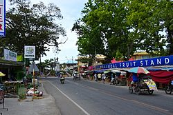
 Poblacion (town centre) | |
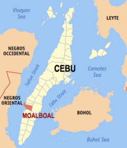
 Map of Cebu with Moalboal highlighted | |
Location within the Philippines | |
| Coordinates: 9°57′N 123°24′E / 9.95°N 123.4°E | |
| Country | |
| Region | Central Visayas |
| Province | Cebu |
| District | 7th district of Cebu |
| Founded | 6 February 1852 |
| Barangays | 15 (see Barangays) |
| Government | |
| • Type | Sangguniang Bayan |
| • mayor of Moalboal[*] | Paz A. Rozgoni |
| • Vice Mayor | Inocentes G. Cabaron |
| • Representative | Peter John D. Calderon |
| • Electorate | 23,585 voters (2022) |
| Area | |
• Total | 124.86 km2 (48.21 sq mi) |
| Elevation | 30 m (100 ft) |
| Population (2020 census)[3] | |
• Total | 36,930 |
| • Density | 300/km2 (770/sq mi) |
| • Households | 8,582 |
| Economy | |
| • Income class | 4th municipal income class |
| • Poverty incidence | 26.58% (2015)[4] |
| • Revenue | ₱ 188.5 million (2020) |
| • Assets | ₱ 403.3 million (2020) |
| • Liabilities | ₱ 136.3 million (2020) |
| • Expenditure | ₱ 153.5 million (2020) |
| Time zone | UTC+8 (PST) |
| ZIP code | 6032 |
| PSGC | |
| IDD : area code | +63 (0)32 |
| Native languages | Cebuano Tagalog |
| Website | www |
Moalboal, officially the Municipality of Moalboal (Template:Lang-ceb; Template:Lang-tgl), is a 4th class municipality in the province of Cebu, Philippines. According to the 2020 census, it has a population of 36,930 people.[3]
Extending as a peninsula on the south-western tip of Cebu, Moalboal is bordered to the west by the Tañon Strait. Negros Island can be seen from the western shoreline. Moalboal is located 89 kilometres (55 mi) from Cebu City, about 2½ hours by public bus.
Moalboal is bordered to the north by the town of Alcantara, to the west is the Tañon Strait, to the east is the town of Argao, and to the south is the town of Badian.
Pescador Island, a popular tourist attraction, is part of the municipality.
Barangays
Moalboal comprises 15 barangays:
| PSGC | Barangay | Population | ±% p.a. | Date of Fiesta | |||
|---|---|---|---|---|---|---|---|
| 2020[3] | 2010[5] | ||||||
| 072233001 | Agbalanga | 2.5% | 940 | 916 | 0.26% | 29 September | |
| 072233002 | Bala | 1.9% | 700 | 697 | 0.04% | ||
| 072233003 | Balabagon | 4.9% | 1,825 | 1,572 | 1.50% | 5 April | |
| 072233004 | Basdiot | 16.1% | 5,949 | 5,291 | 1.18% | 27 April | |
| 072233005 | Batadbatad | 3.6% | 1,318 | 1,248 | 0.55% | ||
| 072233006 | Bugho | 4.9% | 1,824 | 1,430 | 2.46% | 28 January | |
| 072233007 | Buguil | 2.0% | 756 | 710 | 0.63% | ||
| 072233016 | Busay | 3.5% | 1,309 | 1,167 | 1.15% | ||
| 072233008 | Lanao | 3.9% | 1,424 | 1,352 | 0.52% | ||
| 072233010 | Poblacion East | 6.8% | 2,521 | 2,223 | 1.27% | 3 May | |
| 072233011 | Poblacion West | 8.8% | 3,240 | 2,742 | 1.68% | 3 May | |
| 072233012 | Saavedra | 7.8% | 2,881 | 2,618 | 0.96% | 15 October | |
| 072233013 | Tomonoy | 5.5% | 2,018 | 1,874 | 0.74% | 8 December | |
| 072233014 | Tuble | 5.4% | 2,012 | 1,591 | 2.38% | 21 January | |
| 072233015 | Tunga | 6.5% | 2,413 | 2,245 | 0.72% | 17 September | |
| Total | 36,930 | 27,676 | 2.93% | ||||
Climate
| Climate data for Moalboal, Cebu | |||||||||||||
|---|---|---|---|---|---|---|---|---|---|---|---|---|---|
| Month | Jan | Feb | Mar | Apr | May | Jun | Jul | Aug | Sep | Oct | Nov | Dec | Year |
| Mean daily maximum °C (°F) | 29 (84) |
30 (86) |
31 (88) |
32 (90) |
31 (88) |
30 (86) |
30 (86) |
30 (86) |
30 (86) |
29 (84) |
29 (84) |
29 (84) |
30 (86) |
| Mean daily minimum °C (°F) | 22 (72) |
22 (72) |
23 (73) |
24 (75) |
25 (77) |
25 (77) |
24 (75) |
24 (75) |
24 (75) |
24 (75) |
24 (75) |
23 (73) |
24 (75) |
| Average precipitation mm (inches) | 42 (1.7) |
34 (1.3) |
40 (1.6) |
61 (2.4) |
124 (4.9) |
188 (7.4) |
190 (7.5) |
191 (7.5) |
189 (7.4) |
186 (7.3) |
124 (4.9) |
73 (2.9) |
1,442 (56.8) |
| Average rainy days | 10.0 | 8.5 | 9.5 | 12.8 | 22.3 | 26.8 | 28.4 | 27.9 | 27.3 | 27.6 | 20.5 | 13.1 | 234.7 |
| Source: Meteoblue [6] | |||||||||||||
Demographics
|
| ||||||||||||||||||||||||||||||||||||||||||||||||
| Source: Philippine Statistics Authority[7][5][8][9] | |||||||||||||||||||||||||||||||||||||||||||||||||
Though the majority of the people in Moalboal are Cebuanos, a few members of cultural minorities have found their way there. Bajaus who are similar to Muslim nomads, are often seen in the streets, especially during the holiday season, as some of them make their living by begging. There is no evidence though that the badjaos have taken up permanent residence in the town.
Economy
Industry and trade
Moalboal is a peninsula and therefore it is almost entirely surrounded by water. The majority of the people who live in the flat lands engage in fishing as their main mode of livelihood. Those who live in the mountain regions, like Agbalanga and Bala, live through farming.
The common mode of transportation is by bicycles with side cars, known locally as pedicabs or, depending on the distance, tricycles with side cars, called trisikads.
Tourism

Since the 1970s, Moalboal has developed a tourism industry based on recreational diving and beaches. Panagsama Beach (Basidot) is where most resorts and restaurants are established, while further north on the peninsula, in Saavedra, is White Beach (Basdako), a two-kilometre (1.2 mi) beach. This beach used to be mostly frequented by locals, but has since developed an international tourist trade.
In Moalboal, most tourists stay at either Panagsama Beach (Basdiot) or White Beach (Basdako), both located 3–5 kilometres (1.9–3.1 mi) away from the main bus stop in Moalboal.


Recreational diving is the main tourist activity in Moalboal, and reefs along the west coast of the Copton peninsula are home to a great variety of marine life. Pescador Island, about 3 kilometres (1.9 mi) off the coast, is the most popular dive spot with an underwater cave known as "the Cathedral". Indeed a breath-taking view of the underwater world as some of the country’s best diving sites in Moalboal as the terrain of the reef follows the entire coast line, making the place ideal for scuba-diving, snorkeling and freediving, with a shallow drop-off close to shore dropping down to more than 40 metres (130 ft). The area is also known to be a sanctuary for sea turtles, as well as vast schools of sardines. nearby Pescadores Seaview Suites. Whale shark, dolphins and threshers are also seen out of the blue.
Moalboal has been featured by several Filipino TV show hosts, such as Kuya Kim Atienza of Matanglawin, Drew Arellano of Biyahe ni Drew, Slater Young, and Kryz Uy.
Moalboal also serves as a base for other activities, such as canyoneering in Badian and the Kawasan Falls, 20 kilometres (12 mi) away from Moalboal.
Currently, tours are only booked online thru the Cebu Provincial Tourism Portal
Fiesta
The annual feast of Moalboal is held on the 15 and 16 of May. Moalboal is known also for its "Kagasangan Festival" (coral) in which they perform tribal dances and music. It is held in honor of St. John of Nepomuk, the town's patron saint.
Gallery
-
Moalboal Municipal Hall
-
White Beach
-
Coral reef
-
Moalboal Church
References
- ^ Municipality of Moalboal | (DILG)
- ^ "Province: Cebu". PSGC Interactive. Quezon City, Philippines: Philippine Statistics Authority. Retrieved 12 November 2016.
- ^ a b c Census of Population (2020). "Region VII (Central Visayas)". Total Population by Province, City, Municipality and Barangay. Philippine Statistics Authority. Retrieved 8 July 2021.
- ^ "PSA releases the 2015 Municipal and City Level Poverty Estimates". Quezon City, Philippines. Retrieved 12 October 2019.
- ^ a b Census of Population and Housing (2010). "Region VII (Central Visayas)" (PDF). Total Population by Province, City, Municipality and Barangay. National Statistics Office. Retrieved 29 June 2016.
- ^ "Moalboal: Average Temperatures and Rainfall". Meteoblue. Retrieved 10 May 2020.
- ^ Census of Population (2015). "Region VII (Central Visayas)". Total Population by Province, City, Municipality and Barangay. Philippine Statistics Authority. Retrieved 20 June 2016.
- ^ Censuses of Population (1903–2007). "Region VII (Central Visayas)". Table 1. Population Enumerated in Various Censuses by Province/Highly Urbanized City: 1903 to 2007. National Statistics Office.
- ^ "Province of Cebu". Municipality Population Data. Local Water Utilities Administration Research Division. Retrieved 17 December 2016.


