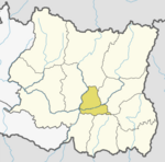
Mahalaxmi Municipality, Dhankuta
Appearance
Mahalaxmi
महालक्ष्मी नगरपालिका | |
|---|---|
| Mahalaxmi Municipality | |
| Coordinates: 27°07′N 87°19′E / 27.11°N 87.31°E | |
| Country | |
| Province | Province No. 1 |
| District | Dhankuta District |
| Total Wards | 9 |
| Government | |
| • Mayor | Mr. Parshuram Nepal (NCP) |
| • Deputy Mayor | Mrs. Manju Adhikari (NCP) |
| Area of Municipality | |
• Total | 126.3 km2 (48.8 sq mi) |
| Highest elevation | 2,696 m (8,845 ft) |
| Lowest elevation | 250 m (820 ft) |
| Population (2011) | |
• Total | 24,800 |
| Languages | |
| • Official | Nepali |
| Time zone | UTC+5:45 (NST) |
| Website | official website |
Mahalaxmi (Template:Lang-ne) is a municipality in Dhankuta District of Province No. 1 in Nepal. It is a municipality out of 3 urban municipalities in Dhankuta District. Total area of the municipality is 126.3 km (78.5 mi) and according to 2011 census of Nepal, the population of this municipality is 24,800. The municipality is divided into 9 wards. The headquarter of the municipality is in Jitpur Bazar.[1] [2]
References
- ^ "Mahalaxmi Municipality in Nepal Population". www.citypopulation.de. 8 October 2017. Retrieved 2 March 2018.
- ^ "District Corrected Last for RAJAPATRA" (PDF). www.mofald.gov.np. Retrieved 2 March 2018.


