Itambacuri
Appearance
From Wikipedia, the free encyclopedia
This is an old revision of this page, as edited by El C (talk | contribs) at 00:12, 22 March 2020 (Reverted edits by 39.33.241.201 (talk) to last version by Monkbot). The present address (URL) is a permanent link to this revision, which may differ significantly from the current revision.
Revision as of 00:12, 22 March 2020 by El C (talk | contribs) (Reverted edits by 39.33.241.201 (talk) to last version by Monkbot)
Municipality in Southeast, Brazil
Itambacuri | |
|---|---|
 | |
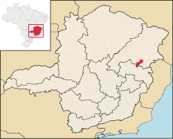
 Location in Minas Gerais state | |
| Coordinates: 18°01′S 41°42′W / 18.017°S 41.700°W / -18.017; -41.700 | |
| Country | Brazil |
| Region | Southeast |
| State | Minas Gerais |
| Mesoregion | Vale do Rio Doce |
| Microregion | Governador Valadares |
| Population (2004) | |
• Total | 23,424 |
| Time zone | UTC-03:00 (BRT) |
| • Summer (DST) | UTC-02:00 (BRST) |
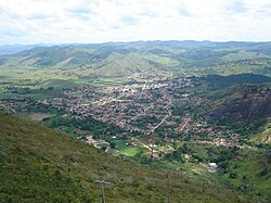
Itambacuri is a Brazilian municipality located in the state of Minas Gerais.[1] As of 2004[update] its population is estimated to be 23,424. Itambacuri contains its own airport, referred to as the 'Itambacuri airport'.[2]
References
This geographical article relating to Minas Gerais is a stub. You can help Wikipedia by expanding it. |


