Christian Quarter


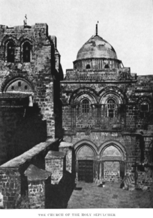
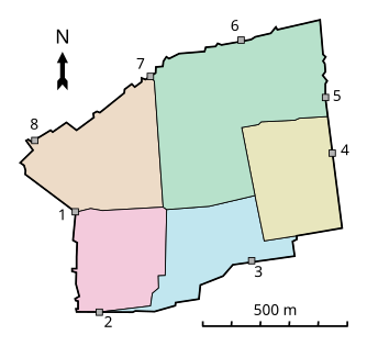
The Christian Quarter (Template:Lang-ar, Harat al-Nasari; Template:Lang-he, Ha-Rova ha-Notsri) is one of the four quarters of the walled Old City of Jerusalem, the other three being the Jewish Quarter, the Muslim Quarter and the Armenian Quarter. The Christian Quarter is situated in the northwestern corner of the Old City, extending from the New Gate in the north, along the western wall of the Old City as far as the Jaffa Gate, along the Jaffa Gate - Western Wall route in the south, bordering on the Jewish and Armenian Quarters, as far as the Damascus Gate in the east, where it borders on the Muslim Quarter. The Christian quarter contains about 40 Christian holy places. Among them is the Church of the Holy Sepulchre, one of Christianity's holiest places.
History

The Christian quarter was built around the Church of the Holy Sepulchre which is the heart of the quarter. Around the church there are other churches and monasteries. In general the quarter contains few houses, which are mostly concentrated in the southern-eastern part of the quarter. It contains mostly religious tourists and educational buildings, such as the Lutheran school and St. Pierre school.
Christian buildings stand on much of the quarter. Besides the Church of the Holy Sepulchre, the largest site, the Patriarchate of the Greek Orthodox, the Franciscan monastery, San Salvatore and the Latin Patriarchate take up significant areas as well.
The quarter also contains souvenir shops, coffee houses, restaurants and hotels. The shops are concentrated in the market street, David Street, and along the Christian Road. Some of the hotels, such as the Casa Nova hotel and the Greek Catholic hotel, were built by the churches as places for visitors to stay. Others are private hotels.
The quarter contains some small museums, such as the museum of the Greek Orthodox Patriarchate. In the southwestern part of the quarter there is a pool called Hezekiah's Pool that was used to store rain water for the area.
In the 19th century, European countries sought to expand their influence in Jerusalem and began constructing several structures in the Christian quarter. The Ottoman authorities attempted to halt European influence and established rules for buying land in the area, but personal interventions from the heads of those countries, including Wilhelm II of Germany and Franz Joseph of Austria, led to construction of some buildings for those countries' religious authorities.
At the end of the 19th century, there was no further free land for development in the Christian Quarter. In the same period, the Suez Canal had opened and many Christians travelled to the Holy Land. This led to intensified competition between the European powers for influence in Jerusalem. France built hospitals, a monastery, and hostels for visitors outside the Old City adjacent to the Christian quarter - an area which became known as the French area. The Russians located themselves in the nearby Russian Compound.
There was a natural desire for easy travel between the Christian Quarter and the new development, but at the time the Old City walls formed a barrier and travellers were forced to take an indirect path through either Jaffa Gate or Nablus Gate. In 1898, the Ottomans accepted the request of the European countries and breached a new gate in the Old City walls, in the area of the new development. The gate was called "The New Gate".
Landmarks
Churches
- Church of the Holy Sepulchre/Church of the Resurrection
- Lutheran Church of the Redeemer
- Church of John the Baptist
- Alexander Nevsky Cathedral
- Church of St John the Baptist
Monasteries
Mosques
Markets
References
![]() Media related to Christian Quarter, Jerusalem at Wikimedia Commons
Media related to Christian Quarter, Jerusalem at Wikimedia Commons

