Churchill, Queensland
Appearance
| Churchill Ipswich, Queensland | |||||||||||||||
|---|---|---|---|---|---|---|---|---|---|---|---|---|---|---|---|
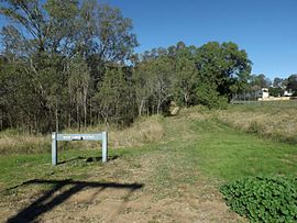
 Mary Evans Reserve, 2016 | |||||||||||||||
| Population | 1,783 (2011)[1] | ||||||||||||||
| Postcode(s) | 4305 | ||||||||||||||
| Location | |||||||||||||||
| LGA(s) | City of Ipswich | ||||||||||||||
| State electorate(s) | Electoral district of Ipswich | ||||||||||||||
| Federal division(s) | Blair | ||||||||||||||
| |||||||||||||||
Churchill is a suburb of Ipswich, Queensland, Australia. At the 2011 Australian Census the suburb recorded a population of 1,783.[1]
The western boundary is marked by the Bremer River, while the eastern boundary follows Deebing Creek.
Education
- Churchill State School
- Bremer State High School
References
- ^ a b Australian Bureau of Statistics (31 October 2012). "Churchill (State Suburb)". 2011 Census QuickStats. Retrieved 25 September 2014.
External links
27°38′07″S 152°45′04″E / 27.63528°S 152.75111°E
