
Dehradun
Dehradun
Dehradun देहरादून | |
|---|---|
city | |
| Population (2001) | |
| • Total | 447,808 |
| Website | http://dehradun.nic.in/ |
Dehradun (Hindi: देहरादून) , also sometimes spelled Dehra Doon, is the capital city of the Uttarakhand state (earlier called Uttaranchal) in India, and the headquarters of Dehradun District.
It is located in the Doon valley, 230 kilometres north of India's capital New Delhi and the Delhi metropolitan area. The district is surrounded by the Himalayas in the north, Sivalik Hills in the south, the river Ganga in the east, and the river Yamuna in the west. The water divide of Ganga and Yamuna passes through the city.
It is also located on the northwestern side of the fertile Gangetic plains of India. Before the creation of Uttarakhand on November 9 2000, Dehradun was a part of Uttar Pradesh. Neighbouring cities and towns include Haridwar, Rishikesh, Roorkee, Mussoorie and Saharanpur.
The products that have made Dehradun known within India are "Dehradooni basmati rice", Backery products and Lychee.
Etymology and History
Dera (or Dehra) is a camp, while Dun or Doon is a reference to a local term used for a river valley between a smaller range Shivaliks and the main Himalayas, and the present town of Dehradun was founded in the early eighteenth century by 'Shri Guru Ram Rai Ji', the elder son of seventh Sikh Guru, Shri Guru Har Rai Ji, and the founder of the Udasin Sect of Ascetics [1], who was exiled came here in 1675, and first settled in village Dhamawala which even today hosts the annual 'Jhanda Fair' on the fifth day after Holi in his memory [2]. Thus the name refers to his Dera or settlement in the valley [3], and marking this settlement is a Darbar called 'Shri Guru Ram Rai Darbar', built in 1699 [4], and modelled on the tomb of Mughal Emperor Jehangir [5]. In Skanda Purana, Dun is mentioned as a part of the region called Kedar Khand, the abode of Shiva. In ancient India during the Mahabharata epic era, Dronacharya the great teacher of Kauravas and Pandavas lived here hence the name "Drona-nagri" [6].
Geography and Climate
| Dehradun | ||||||||||||||||||||||||||||||||||||||||||||||||||||||||||||
|---|---|---|---|---|---|---|---|---|---|---|---|---|---|---|---|---|---|---|---|---|---|---|---|---|---|---|---|---|---|---|---|---|---|---|---|---|---|---|---|---|---|---|---|---|---|---|---|---|---|---|---|---|---|---|---|---|---|---|---|---|
| Climate chart (explanation) | ||||||||||||||||||||||||||||||||||||||||||||||||||||||||||||
| ||||||||||||||||||||||||||||||||||||||||||||||||||||||||||||
| ||||||||||||||||||||||||||||||||||||||||||||||||||||||||||||
Dehradun has a sub-tropical climate with cold winters, warm and crisp springs, hot summers and a strong monsoon. The mountains around Dehradun receive sustained snowfall in winter, but the temperature in the city hardly ever drops below freezing[7].
Transport
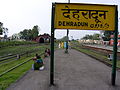
Even though city transportation is now taken care of by blue striped city buses crisscrossing the city, another popular site are the omnipresent blue three wheel vehicles (known as "Vikrams"). These vehicles provide the most common and cheapest form of public transport, however, these vehicles have also been cited as the chief cause of increased levels of noise and air pollution in the city. The Railway station of dehradun is linked with almost all parts of the country with dedicated trains to Dehradun, under Northern Railways. The city is served by the Jolly Grant Airport, 25 km east of the city.
Culture
The posh city of Dehradun is bustling. It is the state capital and is also the home of many government institutions. The center of the city's activities is the popular landmark known as the Clock Tower (Ghanta-ghar), which is a tall structure with 5 functioning clocks; Can enjoy a good ride or go shopping on the Rajpur Road and not to forget its lively Paltan Bazaaar. The numerous high schools of the city attract students from all over the country. During the day it is common to see students (dressed in various high-school uniforms) moving around the city.
Economy
The city has witnessed tremendous growth in the last 20 years. Because of its educational background and high international remittances, Dehradun enjoys a high per capita income, which in dollar terms hovers close to $1800 (national average $800). The city's transition into a large urban centre has been nothing less than phenomenal. Dehradun is in a middle of a commercial & IT boom, which is amplified by the establishment of Software Technology Parks of India (STPI [8]) and various SEZ (special economic zones) through out the city. Right from IT Parks to specifically built industrial belts have proved to be a heaven for industrialists of national and international repute. Combined with excise benefits companies are finding prospective establishment in the city (like other parts of Uttranchal) very attractive. With the construction of the Delhi-Dehradun four lane highway now in full swing, the primary bottleneck endangering the city's growth (the Delhi-Dehradun two lane highway) has been solved. More economic development is expected at a much wider scale.
In Media
When The Beatles came to Rishikesh, they also visited Dehradun and were fascinated by the town. George Harrison wrote a song about it called Dehradun Dehradun.
Tourism

Nearby locations are:
- Gularghati
- Budha Temple & Park Clementown
- Maldevta
- Malsi Deer Park,
- MDDA Park
- Dat Kali Mata Mandir
- Sahastradhara,
- Tapkeshwar Shiv Temple,
- Laxman Sidh Temple,
- Robber's Cave,
- Lachhiwala,
- Abhimanyu Cricket Academy (11 km away from the city)
- Rajaji National Park
- Santhla Devi etc. surround this beautiful city,
Nearby locations are the hill stations of Mussoorie Landour just 36 km away. There is a 16 km (easy) trekking route from Dehradun to Mussoorie.
Dhanaulti is a lovely hill station beyond Mussoorie. Located on Mussoorie-Dhanaulti Road is Himalayan Weavers which produces hand-woven shawls, stoles, scarves and throws using only natural dyes and wool, eri silk and pashmina. Their aim is to produce high quality handloom products, popularize the use of environmentally friendly natural dyes and provide a market for craft products made in the Himalayan region.[9]
Chakrata is another nearby hill station, but it is a good 80 km away. Paonta Sahib is a pilgrimage place for Sikhs with a historic Gurudwara on the banks of the Yamuna. Other nearby religious places are Haridwar and Rishikesh.
Pictures
-
 Dehradun, India
 -
Dehradun Night View from Midway Mussorie.
-
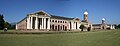 Forest Research Institute, Dehradun, distant view.
 -
 Dehradun as a part of United Provinces, 1903.
 -
The Clock Tower at central Dehradun City.


References
- ^ [.
- ^ Shri Guru Ram Rai Darbar Official website of Dehradun.
- ^ Other cities with similar names are Dera Ismail Khan, Dera Bugti and Dera Ghazi Khan in Pakistan.
- ^ Dehra This article incorporates text from a publication now in the public domain: Chisholm, Hugh, ed. (1911). Encyclopædia Britannica (11th ed.). Cambridge University Press.
{{cite encyclopedia}}: Missing or empty|title=(help) - ^ Dehra Town The Imperial Gazetteer of India, 1909, v. 11, p. 221-223.
- ^ A Brief History and profile of Dehradun Government of Uttarakhand website.
- ^ Climate & Rainfall. Dehradun is prone to hail storms in winter.
- ^ http://www.dehradun.stpi.in
- ^ http://www.himalayanweavers.org
External links
- Official website of Dehradun city
- Complete Information Of Uttarakhand
- Dehradun Guide
- Official website of Dehradun District
- Satellite map of Dehradun
- Template:Wikitravel