
Denmark River
| Denmark River | |
|---|---|
 | |
| Physical characteristics | |
| Mouth | Wilson Inlet |
| Length | 60 kilometres (37 mi) |
The Denmark River is located in the Great Southern region of Western Australia. The river rises near Pardelup and meanders in a southerly direction until it flows through Denmark into Wilson Inlet (along with the Hay River).
The river was named in December 1829 by naval ship's surgeon Thomas Braidwood Wilson after his mentor, naval surgeon Alexander Denmark, Physician of the Fleet, Resident Physician at the Royal Hospital Haslar, and past-Physician to the Mediterranean Fleet. Wilson discovered the river while exploring the area in company of the native Mokare, John Kent (officer in charge of the Commissariat at King George Sound), two convicts and Private William Gough of the 39th Regiment, while his ship the Governor Phillips was being repaired at King George Sound.[4][5][6]
A surveyor noted in 1833 that the local aborigines, the Noongar, called the river "Koorrabup" meaning "place of the black swan".[7]
The river flows through Denmark Pipehead Dam. The two tributaries of the river are Scotsdale Brook and Cleerillup Creek.
-
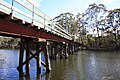 Heritage Rail Bridge spanning the mouth of the Denmark River
 -
 Denmark River flowing into the Wilson Inlet, taken from the Heritage Rail Bridge


Salinity
Historically the Denmark River's water quality declined as a result of land clearing in the catchment area since European settlement. It is estimated that 40% of the river's upper catchment area was cleared and as a result salinity levels increased from 40 mg/L in the 1940s to a peak of 1520 mg/L in 1987 at the Mt Lindesay gauging station.
In 2004 it was announced that salinity levels in the river were decreasing, believed to be the first major river in Australia that had shown a reversal in salinity trends, and that it is possible that the river could provide drinking quality water in the future.[8][9]
By 2012 average annual salinity levels had dropped to 470 mg/L, below World Health Organization guidelines for drinking water for the first time in nearly 40 years. The improved water quality means Denmark Dam has been returned as a drinking water source and back-up water supply for Denmark.[10]
The drop in salinity is mainly attributed to the revegetation of previously cleared farmland with Tasmanian blue gum plantations.[10]
See also
References
- ^ "History of river names – D". Western Australian Land Information Authority. Archived from the original on 19 April 2021. Retrieved 4 August 2008.
- ^ "Bonzle Digital Atlas - Map of Denmark River, WA". 2008. Retrieved 23 November 2008.
- ^ "South Coast Rivercare - Denmark River". 2007. Retrieved 5 November 2010.
- ^ Wilson, Thomas Braidwood (1835). Narrative of a Voyage Round the World. London: Sherwood Gilbert & Piper. p. 261.
- ^ Wilson, Thomas Braidwood (1833), "Extract of a letter received from Dr J.B. Wilson, R.N., dated King George's Sound, 15th December, 1829", in Cross, Joseph (ed.), Journals of Several Expeditions Made in Western Australia During the Years 1829, 1830, 1831 and 1832: Under the Sanction of the Governor, Sir James Stirling, London: J. Cross, pp. 14–26
- ^ Pearn, John (2001). A Doctor In The Garden: Nomen Medici In Botanicis : Australian Flora And The World Of Medicine. Brisbane, Qld: Amphion Press. p. 136. ISBN 978-1864995039.
- ^ "Denmark Western Australia - Denmark River". 2007. Retrieved 5 October 2007.
- ^ "ABC News - Salinity drops in WA's Denmark River". 2004. Retrieved 8 June 2008.
- ^ "Department of Environment - Denmark River Salinity Statement" (PDF). 2004. Retrieved 8 June 2008.
- ^ a b Marmion, Bill (29 October 2012). "Salinity managed in Denmark River". Ministerial Media Statements. Government of Western Australia. Retrieved 24 November 2013.
34°57′42.99″S 117°21′40.88″E / 34.9619417°S 117.3613556°E
Rivers of Western Australia | |
|---|---|
| Rivers of the Gascoyne region | |
| Rivers of the Goldfields–Esperance region | |
| Rivers of the Great Southern region | |
| Rivers of the Kimberley region |
|
| Rivers of the Mid West region | |
| Rivers of the Peel and Perth regions | |
| Rivers of the Pilbara region | |
| Rivers of the South West region | |
| Rivers of the Wheatbelt region | |