Haut-Rhin
You can help expand this article with text translated from the corresponding article in French. (November 2009) Click [show] for important translation instructions.
|
Haut-Rhin | |
|---|---|
 Prefecture building of the Haut-Rhin department, in Colmar | |
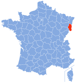
 Location of Haut-Rhin in France | |
| Country | France |
| Region | Grand Est |
| Prefecture | Colmar |
| Subprefectures | Altkirch Mulhouse Thann |
| Government | |
| • President of the General Council | Charles Buttner (UMP) |
| Area | |
• Total | 3,525 km2 (1,361 sq mi) |
| Population (2013) | |
• Total | 758,723 |
| • Rank | 29th |
| • Density | 220/km2 (560/sq mi) |
| Time zone | UTC+1 (CET) |
| • Summer (DST) | UTC+2 (CEST) |
| Department number | 68 |
| Arrondissements | 4 |
| Cantons | 17 |
| Communes | 366 |
| ^1 French Land Register data, which exclude estuaries, and lakes, ponds, and glaciers larger than 1 km2 | |
| Part of a series on |
| Alsace |
|---|
|
|
Haut-Rhin (French pronunciation: [oʁɛ̃]; Alsatian: Owerelsàss) is a department in the Grand Est region of France, named after the Rhine river. Its name means Upper Rhine. Haut-Rhin is the smaller and less populated of the two departments of the former administrative Alsace region, especially after it was amputated in 1871 of the southern territory known since 1922 as Territoire de Belfort, although it is still densely populated compared to the rest of metropolitan France.
Subdivisions
The department consists of the following arrondissements:
History
Haut-Rhin is one of the original 83 departments, created during the French Revolution, on 4 March 1790 through the application of the law of 22 December 1789 in respect of the southern half of the province of Alsace (Haute-Alsace).
Its boundaries have been modified many times:
- 1798, it absorbed Mulhouse, formerly a free city, and the last Swiss enclave in the south of Alsace;
- 1800, it absorbed the whole département of Mont-Terrible;
- 1814, it lost the territories which had been part of Mont-Terrible, which were returned to Switzerland, except for the old principality of Montbéliard;
- 1816, it lost Montbéliard, which was transferred to the département of Doubs;
- 1871, it was mostly annexed by Germany (Treaty of Frankfurt). The remaining French part formed the Territoire de Belfort in 1922;
- 1919, it was reverted to France (Treaty of Versailles) but remains administratively separated from Belfort.
- 1940, it was annexed de facto by Nazi Germany.
- 1944, it was recovered by France.
Geography
Haut-Rhin is bordered by the Territoire de Belfort and Vosges départements and the Vosges Mountains to the west, the Bas-Rhin département to the North, Switzerland to the south and its eastern border with Germany is also the River Rhine. In the centre of the département lies a fertile plain. The climate is semi-continental.
Economy
Haut-Rhin is one of the richest French départements. Mulhouse is the home of a Peugeot automobile factory, manufacturing the 106 and 206 models. The lowest unemployment rate in France can be found in the Southern Sundgau region (approximately 2%). The countryside is marked by hills. Many Haut-Rhinois work in Switzerland, especially in the chemical industries of Basel, but commute from France where living costs are lower.
Law
Alsace and the adjacent Moselle department have a legal system slightly different from the rest of France. The statutes in question date from the period 1871 - 1919 when the area was part of the German Empire. With the return of Alsace-Lorraine to France in 1919, Paris accepted that Alsace and Moselle should retain some local laws in respect of certain matters, especially with regard to hunting, economic life, local government relationships, health insurance and social rights. It includes notably the absence of any formal separation between church and state: several mainstream denominations of the Christian church benefit from state funding, in contrast to principles applied in the rest of France.
Tourism
-
Mulhouse town hall
-
View from the Ballon d'Alsace
Culture
See also
- Cantons of the Haut-Rhin department
- Communes of the Haut-Rhin department
- Arrondissements of the Haut-Rhin department


