Laurino
Laurino | |
|---|---|
| Comune di Laurino | |
 Panoramic view of Laurino | |
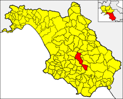
 Laurino within the Province of Salerno | |
| Coordinates: 40°20′N 15°20′E / 40.333°N 15.333°E | |
| Country | Italy |
| Region | Campania |
| Province | Salerno (SA) |
| Frazioni | Pruno, Villa Littorio |
| Government | |
| • Mayor | Romano Gregorio |
| Area | |
| • Total | 70.46 km2 (27.20 sq mi) |
| Elevation | 531 m (1,742 ft) |
| Population (31 August 2017)[2] | |
| • Total | 1,488 |
| • Density | 21/km2 (55/sq mi) |
| Demonym | Laurinesi |
| Time zone | UTC+1 (CET) |
| • Summer (DST) | UTC+2 (CEST) |
| Postal code | 84057 |
| Dialing code | 0974 |
| Patron saint | St. Helena of Laurino |
| Saint day | 22 May |
| Website | Official website |

Laurino is a town and comune in the province of Salerno in the Campania region of southwestern Italy.
Geography
Laurino is a typical medieval hill town of the Cilento, the southernmost part of Campania. It dominates the surrounding landscape, overlooking the Calore Lucano river, which is crossed by two medieval bridges; Laurino was once known as the "pearl of the Calore". The river flows through the Cilento national park from its source up on Mount Cervati; it is known for the wildlife it attracts, such as European otters. There are many laurel trees in the area, which probably gave their name to the village via the Latin Laurus or Laurinus.
The municipality borders with Bellosguardo, Campora, Felitto, Magliano Vetere, Novi Velia, Piaggine, Rofrano, Roscigno, Sacco, Stio and Valle dell'Angelo. It counts two hamlets (frazioni): Pruno and Villa Littorio.[3]
History
The settlement goes back to pre-Christian times. In the 12th century the total population exceeded 3,500, spread between the main town and five surrounding villages. However Laurino was destroyed by the troops of Frederick III of Sicily during the War of the Sicilian Vespers (1282-1302).
Due to migration in recent decades toward the north in search for employment, the current population is just under 2000.
Main sights
- Ruins of the Ducal Palace
- Frescos and wooden carvings of the main church, Santa Maria Maggiore.
- Medieval Bridge and natural springs
- Zipline 500 meters above gorge
The place is known for its natural environment, and initiatives such as the Jazz in Laurino festival in August, which attracts musicians from throughout the country.
See also
References
- ^ "Superficie di Comuni Province e Regioni italiane al 9 ottobre 2011". Italian National Institute of Statistics. Retrieved 16 March 2019.
- ^ "Popolazione Residente al 1° Gennaio 2018". Italian National Institute of Statistics. Retrieved 16 March 2019.
- ^ Template:It icon The frazioni of Laurino at the municipal website[permanent dead link]
External links
- Laurino.info Photoblog
- Zadalampe.com Public & private history of Laurino
- Jazzinlaurino An annual jazz festival


