
Portal:Tropical cyclones
The Tropical Cyclones Portal

A tropical cyclone is a storm system characterized by a large low-pressure center, a closed low-level circulation and a spiral arrangement of numerous thunderstorms that produce strong winds and heavy rainfall. Tropical cyclones feed on the heat released when moist air rises, resulting in condensation of water vapor contained in the moist air. They are fueled by a different heat mechanism than other cyclonic windstorms such as Nor'easters, European windstorms and polar lows, leading to their classification as "warm core" storm systems. Most tropical cyclones originate in the doldrums, approximately ten degrees from the Equator.
The term "tropical" refers to both the geographic origin of these systems, which form almost exclusively in tropical regions of the globe, as well as to their formation in maritime tropical air masses. The term "cyclone" refers to such storms' cyclonic nature, with anticlockwise rotation in the Northern Hemisphere and clockwise rotation in the Southern Hemisphere. Depending on its location and intensity, a tropical cyclone may be referred to by names such as "hurricane", "typhoon", "tropical storm", "cyclonic storm", "tropical depression" or simply "cyclone".
Types of cyclone: 1. A "Typhoon" is a tropical cyclone located in the North-west Pacific Ocean which has the most cyclonic activity and storms occur year-round. 2. A "Hurricane" is also a tropical cyclone located at the North Atlantic Ocean or North-east Pacific Ocean which have an average storm activity and storms typically form between May 15 and November 30. 3. A "Cyclone" is a tropical cyclone that occurs in the South Pacific and Indian Oceans.
Selected named cyclone -

Typhoon Ketsana, known in the Philippines as Tropical Storm Ondoy, was the second-most devastating tropical cyclone of the 2009 Pacific typhoon season, causing $1.15 billion in damages and 665 fatalities, only behind Morakot earlier in the season, which caused 956 deaths and damages worth $6.2 billion. Ketsana was the sixteenth tropical storm, and the eighth typhoon of the season. It was the most devastating tropical cyclone to hit Manila, surpassing Typhoon Patsy (Yoling) in 1970.
Ketsana formed early about 860 km (530 mi) to the northwest of Palau on September 23, 2009. The depression remained weak and was downgraded to a low pressure area later that day by the Japan Meteorological Agency (JMA) but after drifting through extremely favorable conditions, it intensified the next day and was categorized as Tropical Depression by the Philippine Atmospheric, Geophysical and Astronomical Services Administration (PAGASA) and was given the name Ondoy after entering the Philippine Area of Responsibility. The Joint Typhoon Warning Center (JTWC) issued a Tropical Cyclone Formation Alert on the depression. It was then upgraded to a tropical depression by the JMA later that morning before the JTWC followed suit early on September 25, designating the depression as 17W. Soon, Ketsana was upgraded to a tropical storm before passing over the Philippines. As it moved into the South China Sea the storm intensified while moving toward the west, and was categorized as a Severe Tropical Storm by the JMA. (Full article...)
Selected article -
Tropical cyclone forecasting is the science of forecasting where a tropical cyclone's center, and its effects, are expected to be at some point in the future. There are several elements to tropical cyclone forecasting: track forecasting, intensity forecasting, rainfall forecasting, storm surge, tornado, and seasonal forecasting. While skill is increasing in regard to track forecasting, intensity forecasting skill remains unchanged over the past several years. Seasonal forecasting began in the 1980s in the Atlantic basin and has spread into other basins in the years since. (Full article...)
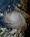
Selected image -

Selected season -

The 2002 Pacific hurricane season was an average season which produced fifteen named storms. Eight hurricanes formed, including a record-equaling three Category 5 hurricanes, a record it shares with the 1994 and 2018 seasons. It was also a near-average season in terms of accumulated cyclone energy (ACE), having an ACE of 125. The season officially began on May 15, 2002 in the East Pacific Ocean, and on June 1, 2002 in the Central Pacific; both ended on November 30. These dates conventionally delimit the period of each year when most tropical cyclone formation occurs in these regions of the Pacific. The first system of the 2002 season, Hurricane Alma, formed on May 24, and the last, Tropical Depression Sixteen-E, dissipated on November 16.
The strongest hurricane of the season, Kenna, formed on October 22 and peaked as a Category 5 hurricane two days later. Land impact was relatively significant. Kenna made landfall near Puerto Vallarta, located in the Mexican state of Jalisco on October 25, killing four people. Kenna was, at the time, the second-most powerful hurricane to ever strike the western coast of Mexico, hitting with winds of 140 mph (220 km/h), as well as the strongest landfall in terms of windspeed until Hurricane Patricia in 2015. Elsewhere, Tropical Storm Julio made landfall in Mexico, and Tropical Storm Boris dumped torrential rain along the Mexican coast, despite remaining offshore. Hurricanes Elida and Hernan also reached Category 5 intensity, but neither caused any damage. Damage across the basin reached $101.23 million (2002 USD), while 7 people were killed by Julio and Kenna. (Full article...)
Related portals
Currently active tropical cyclones

Italicized basins are unofficial.
- North Atlantic (2024)
- No active systems
- East and Central Pacific (2024)
- No active systems
- West Pacific (2024)
- Tropical depression 28W
- North Indian Ocean (2024)
- No active systems
- Mediterranean (2024–25)
- No active systems
- South-West Indian Ocean (2024–25)
- No active systems
- Australian region (2024–25)
- No active systems
- South Pacific (2024–25)
- No active systems
- South Atlantic (2024–25)
- No active systems
Last updated: 16:12, 22 December 2024 (UTC)
Tropical cyclone anniversaries

December 26
- 2000 - Cyclone 04B (pictured) made landfall over Sri Lanka at peak intensity as a Category 1 tropical cyclone, making it the strongest cyclone to hit the island nation for nearly 25 years.
- 2001 - Tropical Storm Vamei formed to the east of Singapore at a latitude of 1.4° north, becoming the closest-forming tropical cyclone to the Equator.

- December 27, 2004 - Cyclone Chambo (pictured) reached its peak intensity with 155 km/h (100 mph) winds in the open Indian Ocean.

December 28
- 1997 - Cyclone Sid makes landfall over in the northern portion of the Northern Territory, just a day before weakening into a low-pressure area.
- 2002 - Cyclone Zoe (pictured) reached its peak intensity with a central pressure of 890 hPa (mbar), becoming the most intense tropical cyclone ever recorded in the Southern Hemisphere.
Did you know…


- …that the Joint Typhoon Warning Center considers that Typhoon Vera (pictured) of 1986 is actually two distinct systems, formed from two separated low-level circulations?
- …that Cyclone Freddy (track pictured) in 2023 was the longest-lasting tropical cyclone recorded?
- …that the typhoons of 2024—Yinxing, Toraji, Usagi, and Man-yi (pictured)—made history as the first recorded instance since 1951 of four tropical cyclones coexisting in November?
- …that Hurricane Otis (pictured) in 2023 was the first Pacific hurricane to make landfall at Category 5 intensity and surpassed Hurricane Patricia as the strongest landfalling Pacific hurricane on record?
General images -
-
 Surface weather map of the 1935 Labor Day hurricane moving up the west coast of Florida (from Tropical cyclone observation)
 -

-
 Hurricane Catarina, a rare South Atlantic tropical cyclone viewed from the International Space Station on March 26, 2004 (from Cyclone)
 -
 The number of $1 billion Atlantic hurricanes almost doubled from the 1980s to the 2010s, and inflation-adjusted costs have increased more than elevenfold. The increases have been attributed to climate change and to greater numbers of people moving to coastal areas. (from Effects of tropical cyclones)
 -
 An extratropical cyclone near Iceland (from Cyclone)
 -
 Percentages of hurricane deaths in the United States from 1970 to 1999. (from Effects of tropical cyclones)
 -
 Radar image of Hurricane Erika making landfall over Northeastern Mexico (from Tropical cyclone observation)
 -
 The aftermath of Hurricane Katrina in Gulfport, Mississippi. Katrina was the costliest tropical cyclone in United States history. (from Effects of tropical cyclones)
 -
 (from Cyclone)
 -
 Hurricane Isabel (2003)'s effect on the North Carolina Outer Banks (from Effects of tropical cyclones)
 -
 Chart with concurrent information for Hurricane Arlene and Tropical Storm Bret logged and plotted (from Tropical cyclone preparedness)
 -
 A polar low over the Sea of Japan in December 2009 (from Cyclone)
 -
 Tropical cyclones form when the energy released by the condensation of moisture in rising air causes a positive feedback loop over warm ocean waters. (from Cyclone)
 -
 2017 Atlantic hurricane season summary map (from Cyclone)
 -
 All but the most expensive bottles of water were sold out at this Publix supermarket before Hurricane Irma; in the week preceding the storm, water sold out soon after shipments arrived (from Tropical cyclone preparedness)
 -
 (from Cyclone)
 -
 (from Cyclone)
 -
-
 Aerial image of destroyed houses in Tacloban, following Typhoon Haiyan (from Effects of tropical cyclones)
 -
 Broken concrete utility pole in Puerto Rico after Hurricane Maria in 2017, which ranks fourth in costliest US tropical cyclones. (from Effects of tropical cyclones)
 -
 Hurricane response involves working in hazardous conditions, including contamination and electrocution hazards from floodwater.
 -

-
 (from Cyclone)
 -
 Flooding in Port Arthur, Texas caused by Hurricane Harvey. Harvey was the wettest and second-costliest tropical cyclone in United States history. (from Effects of tropical cyclones)
 -
 Personnel and equipment from the National Guard of the United States en route to Hurricane Florence response efforts in 2018
 -
 Cyclone on Mars, imaged by the Hubble Space Telescope (from Cyclone)
 -

-
 (from Cyclone)
 -
 A fictitious synoptic chart of an extratropical cyclone affecting the UK and Ireland. The blue arrows between isobars indicate the direction of the wind, while the "L" symbol denotes the centre of the "low". Note the occluded, cold and warm frontal boundaries. (from Cyclone)
 -

-
 An example of a chart for Matthew showing its five-day forecast track (from Tropical cyclone preparedness)
 -
 The initial extratropical low-pressure area forms at the location of the red dot on the image. It is usually perpendicular (at a right angle to) the leaf-like cloud formation seen on satellite during the early stage of cyclogenesis. The location of the axis of the upper level jet stream is in light blue. (from Cyclone)
 -
 The dangerous semicircle is the upper-right corner, with the arrow marking the direction of motion of a Northern Hemisphere storm. Note that typhoons, etc. are asymmetrical, and semicircle is a convenient misnomer. (from Effects of tropical cyclones)
 -
 Comparison between extratropical and tropical cyclones on surface analysis (from Cyclone)


.png)


.jpg)


.jpg)


_(50).jpg)
.jpg)


.png)


 Featured list -

Accompanying Hurricane Katrina's catastrophic coastal impacts was a moderate tornado outbreak spawned by the cyclone's outer bands. The event spanned August 26–31, 2005, with 57 tornadoes touching down across 8 states. One person died and numerous communities suffered damage of varying degrees from central Mississippi to Pennsylvania, with Georgia sustaining record monetary damage for the month of August. Due to extreme devastation in coastal areas of Louisiana and Mississippi, multiple tornadoes may have been overlooked—overshadowed by the effects of storm surge and large-scale wind—and thus the full extent of the hurricane's tornado outbreak is uncertain. Furthermore, an indeterminate number of waterspouts likely formed throughout the life cycle of Hurricane Katrina.
The outbreak began with an isolated F2 over the Florida Keys on August 26; no tornadoes were recorded the following day as the storm traversed the Gulf of Mexico. Four weak tornadoes were observed on August 28 as the hurricane approached land, each causing little damage. Coincident with Katrina's landfall, activity began in earnest on August 29 with numerous tornadoes touching down across Gulf Coast states. Georgia suffered the greatest impact on this day, with multiple F1 and F2 tornadoes causing significant damage; one person died in Carroll County, marking the first known instance of a tornado-related death in the state during August. A record 18 tornadoes touched down across Georgia on August 29, far exceeding the previous daily record of just 2 tornadoes for the month throughout the state. Activity diminished over the subsequent two days as the former hurricane moved northward. Several more tornadoes touched down across the Mid-Atlantic states before the cessation of the outbreak just after midnight local time on August 31. (Full article...)
Topics

Subcategories

Related WikiProjects
WikiProject Tropical cyclones is the central point of coordination for Wikipedia's coverage of tropical cyclones. Feel free to help!
WikiProject Weather is the main center point of coordination for Wikipedia's coverage of meteorology in general, and the parent project of WikiProject Tropical cyclones. Three other branches of WikiProject Weather in particular share significant overlaps with WikiProject Tropical cyclones:
- The Non-tropical storms task force coordinates most of Wikipedia's coverage on extratropical cyclones, which tropical cyclones often transition into near the end of their lifespan.
- The Floods task force takes on the scope of flooding events all over the world, with rainfall from tropical cyclones a significant factor in many of them.
- WikiProject Severe weather documents the effects of extreme weather such as tornadoes, which landfalling tropical cyclones can produce.
Things you can do
 |
Here are some tasks awaiting attention:
|
Wikimedia
The following Wikimedia Foundation sister projects provide more on this subject:
-
 Commons
Free media repository -
 Wikibooks
Free textbooks and manuals -
 Wikidata
Free knowledge base -
 Wikinews
Free-content news -
 Wikiquote
Collection of quotations -
 Wikisource
Free-content library -
 Wikiversity
Free learning tools -
 Wikivoyage
Free travel guide -
 Wiktionary
Dictionary and thesaurus


