
Princess Juliana International Airport
Princess Juliana International Airport | |||||||||||
|---|---|---|---|---|---|---|---|---|---|---|---|
 | |||||||||||
| Summary | |||||||||||
| Airport type | Public | ||||||||||
| Owner | Princess Juliana Int'l Airport Holding Company N.V. | ||||||||||
| Location | Sint Maarten (St. Martin) | ||||||||||
| Hub for | |||||||||||
| Elevation AMSL | 14 ft / 4 m | ||||||||||
| Website | www.pjiae.com | ||||||||||
| Map | |||||||||||
 TNCM Location in Sint Maarten | |||||||||||
| Runways | |||||||||||
| |||||||||||
Source: airnav.com[1] | |||||||||||
Princess Juliana International Airport (IATA: SXM, ICAO: TNCM) (also known as Sint Maarten International Airport) serves the Dutch part of the island of Saint Martin. In 2007, the airport handled 1,647,824 passengers and 103,650 aircraft movements.[2] The airport serves as a hub for Windward Islands Airways and is the major gateway for the smaller Leeward Islands, including Anguilla, Saba, St. Barthélemy and St. Eustatius. It is named after Juliana of the Netherlands, who as crown princess landed here in 1944, the year after the airport opened. There is also an airport on the French side of the island, called Aéroport de Grand Case or L'Espérance Airport. The airport is perhaps best known for very low-altitude flyover landing approaches due to one end of its runway being extremely close to the shore and Maho Beach.
History
The airport was started as a military airstrip in 1942. It was converted to a civilian airport in 1943. In 1964 the airport was remodeled and relocated, with a new terminal building and control tower. The facilities were upgraded in 1985 and 2001.
Modernisation
Because of increased passenger traffic and the expected growth of passenger traffic in the near future, Princess Juliana International Airport is being heavily modernized following a three-phased masterplan, commissioned in 1997.[3]
Phase I was a short-term program in order to upgrade existing facilities and improve the level of service at various points. This included widening, strengthening and renovating the runway, increasing the bearing capacity of the taxiways, construction of a new apron and an upgrade of the (old) terminal. Phase I was completed in 2001.[4]
Phase II included the construction of a radar facility and a new air traffic control tower, the construction of a new and more modern, 27,000 square metres (290,000 sq ft), terminal, capable of handling 2.5 million passengers per year, and the construction of a Runway End Safety Area (RESA) of 150 metres (490 ft), including a 60 metres (200 ft) overrun, on both ends of its runway, to comply with ICAO rules. The new air traffic control tower and the radar station commenced operations on March 29, 2004, while the new terminal opened in late October 2006.[5] The terminal has 4–5 jetways for large aircraft like 747s.
If traffic develops as forecast, Phase III of the masterplan will be executed, consisting of an extension of the new terminal building and the construction of a full parallel taxiway system.[6] The new terminal building will also have more jetways and services etc.
However, the oil price increases since 2003 began impacting discretionary air travel worldwide by early 2008,[7] and the prospect of further price increases[8] threatens to reverse the recent expansion of tourist travel by jet which began with the 1980s oil glut.[9]
Runway and facilities
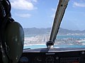
Because the approach to Runway 10 is over water, pilots can become disoriented regarding their perceived altitude when operating under visual flight rules. Normal instrument checks, coupled with experience and situational awareness, mitigate potential problems. The departure from Runway 10 presents more "difficulties" than the approach, with a turn required to avoid mountains in the departure path.
Arriving aircraft approach the island on the last section of the final approach for Runway 10, following a 3° glide slope flying low over the famous Maho Beach. Pictures of low flying aircraft were published in several news magazines worldwide in early 2000. The thrilling approaches and ease of access for shooting spectacular images, made the airport one of the world's favorite places among planespotters. To meet changing international and local regulations a 150-metre (490 ft) safety extension was required.
Despite the reputed difficulties in approach, there have been no records of major incidents at the airport, although ALM Flight 980 crashed 30 miles (48 km) from St. Croix on May 2, 1970, after several unsuccessful landing attempts at PJIA in bad weather.
In late 2008, Runway 09/27 was renumbered as 10/28.[1]
Apron
The main apron measures 72,500 square metres (780,000 sq ft) with another 5,000 square metres (54,000 sq ft) on Eastern apron. For freight handling a dedicated apron of 7,000 square metres (75,000 sq ft) is available.[11]
Terminal
The new four-story terminal building offers 27,000 square metres (290,000 sq ft) of floor space and is fully air-conditioned. Available facilities include 42 check-in desks, eight transit desks and eleven boarding gates. There are ten immigration booths for arriving passengers and five exit-control booths for departing passengers.[11] The building also features 40 shops and food & beverage units—some unique to St. Maarten—promoted under the retail theme 'So Much More'.
Private aviation
To accommodate the growing international and local traffic of private aircraft, PJIA has a Fixed Base Operator building, offering office space and private lounges with dedicated customs.[11]
Tower
Since official opening of the new control tower, PJIA air traffic controllers have two radar systems at their disposal with ranges of 50 nautical miles (93 km) and 250 nautical miles (460 km). PJIA controllers manage 4,000 square NM of airspace around the airport. Besides providing approach, tower and ground control at PJIA, these controllers also provide approach control for Clayton J. Lloyd International Airport (Anguilla), L'Espérance Airport (French Saint Martin), Gustaf III Airport (St. Barths), F.D. Roosevelt Airport (St. Eustatius) and Juancho E. Yrausquin Airport (Saba).
Navigation
PJIA is equipped with VOR/DME and NDB. The airport's official operating hours are 07:00–21:00.[11]
Joint border control with France
In 1994, the Kingdom of the Netherlands and France signed the Franco-Dutch treaty on Saint Martin border controls, which allows for joint Franco-Dutch border controls on so-called "risk flights". After some delay, the treaty was ratified in November 2006 in the Netherlands, and subsequently entered into force on 1 August 2007. Though the treaty is now in force, its provisions are not yet implemented as the working group specified in the treaty is not yet installed.
Accidents and Incidents
Although the airport is as close to the beach as it is, there have only been 2 major accidents.
- 2 May 1970 – ALM Flight 980, a McDonnell Douglas DC-9CF crashed into the ocean in bad weather killing 22 of the 57 passengers in addition to one crew member. The cause was found to be fuel exhaustion due to several attempts to land the aircraft. The aircraft was not recovered.
- 21 December 1972 – Air France De Havilland Canada Twin Otter crashed into the ocean en route from Guadeloupe, killing all 11 passengers on board along with both pilots.
In popular culture
- Princess Juliana International Airport is the airport featured in the free demo version of Microsoft Flight Simulator X. In the full version of the program, it is the destination on the mission called "Caribbean Landing".
- The History Channel program Most Extreme Airports ranks Princess Juliana Airport as the 4th most dangerous airport in the world.[12]
Airlines and destinations
Charter or Seasonal
Cargo airlines
| Airlines | Destinations |
|---|---|
| Amerijet International | Miami, Santiago de los Caballeros, Santo Domingo |
| DHL Aviation | Antigua |
| FedEx Feeder operated by Mountain Air Cargo | San Juan |
| Four Star Air Cargo | San Juan |
| LIAT Quikpak | Santo Domingo |
| Roblex Aviation | San Juan |
| Skyway Enterprises | San Juan |
Gallery
- Photos
-
 A Piper PA-28 Cherokee light aircraft on final approach for, at the time, Runway 09.
 -
 The new Terminal building from the inside.
 -
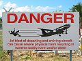 Warning sign between runway 10 and Maho Beach.
 -
 Air France Airbus A340 landing in Princess Juliana International Airport.
 -
 Flight Schedule.


See also
References
- ^ a b Airnav.com on:Princess Juliana International Airport, visited 20 December 2011
- ^ Company website: Traffic statistics, visited 21 December 2011
- ^ Company website with PJIAE Masterplan, visited 21 December 2011
- ^ Masterplan Phase I: 1997–2001, visited 21 December 2011
- ^ PJIAE Masterplan Phase II, visited 21 December 2011
- ^ PJIAE Masterplan: Phase III, visited 21 December 2011
- ^ Adams, Marilyn. "Rising costs reshaping air travel across the USA". USA Today. Retrieved 2008-05-10.
- ^ Lesova, Polya (2008-05-06). "Goldman Sachs: Oil Prices May Hit $150–$200 a Barrel". Fox Business Network. Retrieved 2008-05-08. [dead link]
- ^ Whipple, Tom. "The Peak Oil Crisis: The Half-Life For Air Travel". www.inteldaily.com. Retrieved 2008-05-10.
- ^ Video missing – only still available
- ^ a b c d PJIA website: PJIAE Company Profile, 2007, visited 20 December 2011
- ^ Most Extreme Airports; The History Channel; August 26, 2010
External links
- Princess Juliana International Airport (Official Website)
- Aviation Pioneers of the Caribbean
- So Much More: PJIA's retail theme
- Template:WAD
- Airport information for TNCM/SXM at Great Circle Mapper. Source: DAFIF (effective October 2006).
- Current weather for TNCM at NOAA/NWS
- Accident history for SXM at Aviation Safety Network
- Video-Compilation of a landings
- [1]