
Sungai Johor Bridge
Sungai Johor Bridge Jambatan Sungai Johor جمبتن سوڠاي جوهر | |
|---|---|
 | |
| Coordinates | 1°31′55″N 104°01′19″E / 1.532°N 104.022°E |
| Carries | Motor vehicles |
| Crosses | Johor River |
| Locale | |
| Official name | Sungai Johor Bridge |
| Maintained by | Senai-Desaru Expressway Berhad |
| Characteristics | |
| Design | single plane cable stayed bridge |
| Total length | 1.7 km (1.708 m) |
| Width | 740m |
| Longest span | 500m (0.500 km) |
| History | |
| Designer | Government of Malaysia Malaysian Highway Authority (LLM) Ranhill Engineers & Constructors Sdn Bhd |
| Constructed by | Ranhill Engineers & Constructors Sdn Bhd |
| Opened | 2011 |
| Location | |
 | |
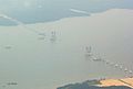
The Sungai Johor Bridge (Malay: Jambatan Sungai Johor Jawi: جمبتن سوڠاي جوهر) is an expressway bridge across Johor River on Senai-Desaru Expressway in Johor, Malaysia. The 1.7 km (1.708 m) single plane cable stayed bridge connects Pulau Juling near Singapore in the west to Tanjung Penyabong in the east. Opened on June 10, 2011,[1] it is currently has the longest central span of any river bridge in Malaysia, followed by Batang Sadong Bridge in Sarawak as the second longest. The bridge also the longest single plane cable-stayed bridge in Malaysia.
History
Construction officially began in 2005. Construction was led by Senai Desaru Expressway Berhad with a main contractor Ranhill Engineers & Constructors Sdn Bhd. The bridge was to have been completed by December 2008, but opening of the bridge was repeatedly delayed, opening together with the 2nd phase of the expressway on June 10, 2011.
Specifications
The bridge is 1.708 metres (1.7 km) long, with a 500-metre (0.500 km) main span across the Johor River. The two main pylons of the bridge rise to a height of 143 meters.[2]
Gallery
-
 Sungai Johor Bridge at night.
 -
 The Sungai Johor Bridge under construction in October 2007
 -
 The Sungai Johor Bridge under construction in January 2009
 -
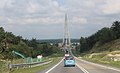 The Sungai Johor Bridge as seen from the westbound of Senai-Johor Expressway in May 2016


See also
References
External links
- Senai-Desaru Expressway Berhad (SDEB)
- Longest cable-stayed bridge planned (The Star, December 18 2006)
1°31′56″N 104°01′20″E / 1.5323°N 104.0223°E
This article about a bridge in Malaysia is a stub. You can help Wikipedia by expanding it. |