User:Nettrom/sandbox/large

 |
|---|
| Constitution |
|
|
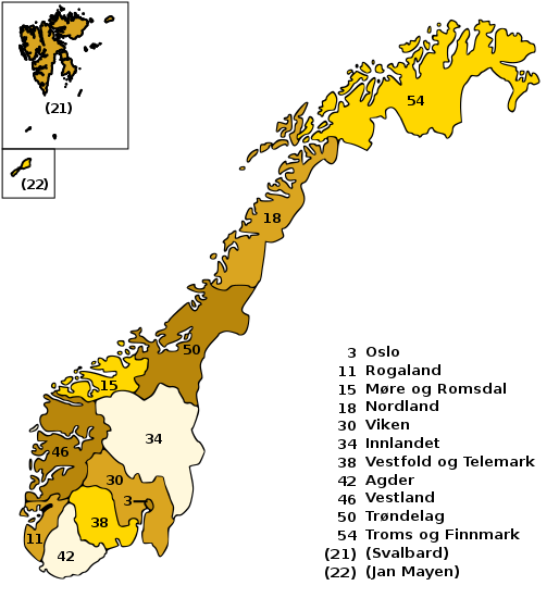
Norway is divided into 19 administrative regions, called counties (singular Norwegian: fylke, plural Norwegian: fylker (Bokmål) / fylke (Nynorsk)); until 1918, they were known as amter. The counties form the first-level subdivisions of Norway and are further divided into 430 municipalities (kommune, pl. kommuner / kommunar). Svalbard and Jan Mayen are outside the county division and ruled directly on national level. The capital Oslo is considered both a county and a municipality.
In recent years, there has been some political debate as to whether counties are a practical, economical, or even necessary level of administration. See politics of Norway for more information.
List of counties
[edit]Below is a list of the Norwegian counties as they have been since 1919, with their current administrative centres. Note that the counties are administered both by appointees of the national government and to a lesser extent by their own elected bodies. The county numbers are from the official numbering system ISO 3166-2:NO, which follows the coastline from the Swedish border in the southeast to the Russian border in the northeast. The number 13 was dropped from the system when the city of Bergen (county no. 13) was merged into Hordaland (county no. 12) in 1972. (There is no connection between the lack of a county number 13 and the belief that 13 is an unlucky number.)
Map
[edit]Responsibilities and significance
[edit]Every county has two main organisations, both with underlying organisations.
- The county municipality (no: Fylkeskommune) has a county council (Norwegian: Fylkesting), whose members are elected by the inhabitants. The county municipality is responsible mainly for some medium level schools, public transport organisation, regional road planning, culture and some more areas.
- The county governor (no: Fylkesmannen) is an authority directly directed by the Norwegian government. It surveills the municipalities and receive complaints from people over their actions. It also controls areas where the government needs local direct ruling outside the municipalities.
Subsection with references using citation templates
[edit]The Knoll area, the oldest part of the University's current location, is located in the northwestern part of the campus.[1] Most disciplines in this area relate to the humanities. Burton Hall is home to the College of Education and Human Development. Many buildings in this area are well over one hundred years old and it includes a 13-building group comprising the Old Campus Historic District that is on the U.S. National Register of Historic Places.[2] A residence hall, Sanford Hall, and a student-apartment complex, Roy Wilkins Hall, are located in this area. The Institute for Advanced Study[3] is located in the Nolte Center. This area is located just south of the Dinkytown neighborhood and business area.
New subsection
[edit]According to the Shanghai index the University of Minnesota is ranked number (something-somthing)[4]
See also
[edit]- Ranked list of Norwegian counties
- Municipalities of Norway
- Regions of Norway
- Traditional districts of Norway
- Metropolitan regions of Norway
- Subdivisions of the Nordic countries
- Lists of County Governors of Norway
References
[edit]- ^ "The Campus Knoll". University of Minnesota. Archived from the original on 27 September 2011.
- ^ "University of Minnesota Heritage Trail". Archived from the original on February 9, 2012.
- ^ Institute for Advanced Study IAS
- ^ "Shanghai results 2014".
Bibliography
[edit]- Danielsen, Rolf; Dyrvik, Ståle; Grønlie, Tore; Helle, Knut; Hovland, Edgar (1991 (2007)). Grunntrekk i norsk historie (1 ed.). Oslo: Universitetsforlaget. ISBN 978-82-00-21273-7.
{{cite book}}: Check date values in:|year=(help)CS1 maint: multiple names: authors list (link) CS1 maint: year (link)


