
Bosanska Krupa
Bosanska Krupa
Босанска Крупа | |
|---|---|
Town and municipality | |
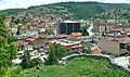
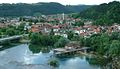
.jpg) Top left: Krvsnica Valley in Una Forest Park; top right: Temple of the Nativity of the Holy Virgin (left) and City Mosque; middle right: footbridge in Ade River; bottom left: panorama view from fortress of Bosanska Krupa; bottom right: city view, watermills in Una River | |
 Coat of arms | |
 Location of Bosanska Krupa within Bosnia and Herzegovina. | |
| Coordinates: 44°53′N 16°09′E / 44.883°N 16.150°E | |
| Country | |
| Entity | Federation of Bosnia and Herzegovina |
| Canton | |
| Geographical region | Bosanska Krajina |
| Government | |
| • Mayor | Afan Arnautovic (SDP BiH) |
| Area | |
| • Town and municipality | 561 km2 (217 sq mi) |
| Population (2013 census) | |
| • Town and municipality | 25,545 |
| • Density | 643/km2 (1,670/sq mi) |
| • Urban | 10,196 |
| Time zone | UTC+1 (CET) |
| • Summer (DST) | UTC+2 (CEST) |
| Area code | +387 37 |
Bosanska Krupa (Serbian Cyrillic: Босанска Крупа) is a municipality located in the Una-Sana Canton of the Federation of Bosnia and Herzegovina, an entity of Bosnia and Herzegovina. As of 2013, it has a population of 29,659 inhabitants.
It is situated on the banks of river Una in northwestern Bosnia and Herzegovina, 30 km (19 mi) northeast from Bihać (350 km away from Sarajevo).
Geography[edit]
Bosanska Krupa is located on the border within the Federation of Bosnia and Herzegovina adjacent to the municipalities of Bužim, Cazin, Bihać, Bosanski Petrovac, Sanski Most, and Krupa na Uni. The last mentioned municipality is part of the Republika Srpska entity and was part of the Bosanska Krupa municipality before the Bosnian War, but after the Dayton Agreement it became a separate municipality.
Settlements[edit]
- Arapuša
- Banjani
- Baštra
- Benakovac
- Donja Suvaja
- Drenova Glavica
- Glavica
- Gorinja
- Gornja Suvaja
- Gornji Bušević
- Gornji Petrovići
- Gudavac
- Hašani
- Ivanjska
- Jasenica
- Jezerski
- Ljusina
- Mahmić Selo
- Mali Badić
- Mali Radić
- Ostrožnica
- Bosanska Otoka
- Perna
- Pištaline
- Potkalinje
- Pučenik
- Srednji Bušević
- Srednji Dubovik
- Velika Jasenica
- Veliki Badić
- Veliki Dubovik
- Veliki Radić
- Vojevac
- Voloder
- Vranjska
- Zalin
Demographics[edit]
Population[edit]
| Population of settlements – Bosanska Krupa municipality | ||||||
|---|---|---|---|---|---|---|
| Settlement | 1961. | 1971. | 1981. | 1991. | 2013. | |
| Total | 46,020 | 50,856 | 55,229 | 58,320 | 29,659 | |
| 1 | Arapuša | 536 | 273 | |||
| 2 | Banjani | 501 | 332 | |||
| 3 | Baštra | 186 | 204 | |||
| 4 | Bosanska Krupa | 8,974 | 12,055 | 14,416 | 10,196 | |
| 5 | Drenova Glavica | 376 | 253 | |||
| 6 | Ivanjska | 633 | 309 | |||
| 7 | Jezerski | 3,322 | 2,756 | |||
| 8 | Ljusina | 1,315 | 1,237 | |||
| 9 | Mahmić Selo | 1,714 | 1,369 | |||
| 10 | Ostrožnica | 1,201 | 794 | |||
| 11 | Otoka | 4,063 | 3,221 | |||
| 12 | Pištaline | 1,541 | 1,316 | |||
| 13 | Veliki Badić | 1,237 | 794 | |||
| 14 | Voloder | 1,060 | 1,114 | |||
Ethnic composition[edit]
| Ethnic composition – Bosanska Krupa town | |||||||
|---|---|---|---|---|---|---|---|
| 2013. | 1991. | 1981. | 1971. | ||||
| Total | 10,196 (100,0%) | 14,416 (100,0%) | 12,055 (100,0%) | 8,974 (100,0%) | |||
| Bosniaks | 9,859 (96,70%) | 9,519 (66,03%) | 6,858 (56,89%) | 6,070 (67,64%) | |||
| Roma | 116 (1,138%) | ||||||
| Unaffiliated | 56 (0,549%) | ||||||
| Serbs | 54 (0,530%) | 4,044 (28,05%) | 3,142 (26,06%) | 2,433 (27,11%) | |||
| Croats | 50 (0,490%) | 102 (0,708%) | 109 (0,904%) | 202 (2,251%) | |||
| Albanians | 21 (0,206%) | ||||||
| Others | 19 (0,186%) | 200 (1,387%) | 182 (1,510%) | 86 (0,958%) | |||
| Unknown | 16 (0,157%) | ||||||
| Yugoslavs | 2 (0,020%) | 551 (3,822%) | 1,764 (14,63%) | 183 (2,039%) | |||
| Macedonians | 1 (0,010%) | ||||||
| Slovenes | 1 (0,010%) | ||||||
| Turks | 1 (0,010%) | ||||||
| Ethnic composition – Bosanska Krupa municipality | ||||||||
|---|---|---|---|---|---|---|---|---|
| 2013. | 1991. | 1981. | 1971. | 1961. | ||||
| Total | 29,659 (100,0%) | 58,320 (100,0%) | 55,229 (100,0%) | 50,856 (100,0%) | 46,020 (100,0%) | |||
| Bosniaks | 23,886 (93,50%) | 43,104 (73,91%) | 37,381 (67,68%) | 31,842 (62,61%) | 23,721 (51,54%) | |||
| Serbs | 1,265 (4,952%) | 13,841 (23,73%) | 15,029 (27,21%) | 18,230 (35,85%) | 20,453 (44,44%) | |||
| Roma | 118 (0,462%) | 3 (0,005%) | ||||||
| Unaffiliated | 106 (0,415%) | |||||||
| Croats | 66 (0,258%) | 139 (0,238%) | 173 (0,313%) | 286 (0,562%) | 453 (0,980%) | |||
| Unknown | 41 (0,161%) | |||||||
| Others | 30 (0,117%) | 528 (0,905%) | 251 (0,454%) | 216 (0,425%) | 122 (0,270%) | |||
| Albanians | 23 (0,090%) | 13 (0,024%) | 13 (0,026%) | |||||
| Yugoslavs | 5 (0,020%) | 708 (1,214%) | 2,314 (4,190%) | 239 (0,470%) | 1,271 (2,760%) | |||
| Slovenes | 3 (0,012%) | 9 (0,016%) | 11 (0,022%) | |||||
| Macedonians | 1 (0,004%) | 7 (0,013%) | ||||||
| Turks | 1 (0,004%) | |||||||
| Montenegrins | 49 (0,089%) | 19 (0,037%) | ||||||
Gallery[edit]
-
 Krupa in the Middle Ages
 -
 Bosanska Krupa
 -
 Bosanska Krupa
 -
 Bosanska Krupa
 -
 Bosanska Krupa


Notable people[edit]
- Džemaludin Čaušević, imam
- Branko Ćopić, writer (Hašani)
- Kosta Hakman, painter
- Elvis Mešić, soccer player
See also[edit]
References[edit]
External links[edit]
- Official site Archived 2021-01-25 at the Wayback Machine
Municipalities of the Una-Sana Canton | ||
|---|---|---|

| International | |
|---|---|
| National | |