
Portal:Ontario
The Ontario Portal


Ontario (/ɒnˈtɛərioʊ/ on-TAIR-ee-oh; French: [ɔ̃taʁjo]) is the southernmost province of Canada. Located in Central Canada, Ontario is the country's most populous province. As of the 2021 Canadian census, it is home to 38.5 percent of the country's population, and is the second-largest province by total area (after Quebec). Ontario is Canada's fourth-largest jurisdiction in total area of all the Canadian provinces and territories. It is home to the nation's capital, Ottawa, and its most populous city, Toronto, which is Ontario's provincial capital.
Ontario is bordered by the province of Manitoba to the west, Hudson Bay and James Bay to the north, and Quebec to the east and northeast. To the south, it is bordered by the U.S. states of (from west to east) Minnesota, Michigan, Ohio, Pennsylvania, and New York. Almost all of Ontario's 2,700 km (1,700 mi) border with the United States follows rivers and lakes: from the westerly Lake of the Woods, eastward along the major rivers and lakes of the Great Lakes/Saint Lawrence River drainage system. There is only about 1 km (5⁄8 mi) of actual land border, made up of portages including Height of Land Portage on the Minnesota border.
The great majority of Ontario's population and arable land is in Southern Ontario, and while agriculture remains a significant industry, the region's economy depends highly on manufacturing. In contrast, Northern Ontario is sparsely populated with cold winters and heavy forestation, with mining and forestry making up the region's major industries. (Full article...)
Selected article -

In Canadian folklore, Mussie is a creature said to live in Muskrat Lake in the Canadian province of Ontario. It is variously described, for example, as a walrus or as a three-eyed Loch Ness Monster-like creature.The legend of Mussie likely began around 1916, though legend claims that Canadian pioneer Samuel de Champlain wrote about it in the early seventeenth century. Mussie has become a part of the local culture and a fixture in the local tourism industry. (Full article...)
General images
-
 North Bay is often considered to be the "Gateway" to Northern Ontario (from Northern Ontario)
 -

-
 Forests, lakes, and rivers dominate much of the Northern Ontario landscape. (from Northern Ontario)
 -
 Ottawa (from Eastern Ontario)
 -
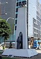 Underground Railroad monument, Windsor (from Southern Ontario)
 -

-
 Ottawa in 2005 (from Southern Ontario)
 -

-
 Köppen Climate Map of Ontario (from Eastern Ontario)
 -
 Typical Great Lakes beach (from Southern Ontario)
 -

-
 Science North in Sudbury. (from Northern Ontario)
 -
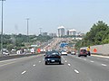 Highway 401 at the Don Valley Parkway in Toronto (from Southern Ontario)


.jpg)


Surrounding areas
Places adjacent to Ontario | |
|---|---|
Selected biography -

Philip-Jon Haarsma /ˈhɑːrzmɑː/ (born June 5, 1964), more commonly known as PJ Haarsma, is a Canadian-born producer and science fiction author best known for his creation of the Rings of Orbis universe, which encompasses The Softwire series of books. Haarsma created a free, online role-playing game, also called the Rings of Orbis, set in the same universe. Both the book-series and the game target young, often reluctant readers in an attempt to encourage them by rewarding them for reading. He is also the founder and CEO of Redbear Films, a production company that focuses on advertisements.
Haarsma developed a school presentation program in which he discusses The Softwire books, astronomy, and other science fiction and science fact topics. He is also one of the co-founders of Kids Need to Read, a United States Internal Revenue Code 501(c)(3) tax exempt public charity that purchases books to donate to underfunded schools and libraries. (Full article...)
Selected image
-
 The CN Tower, located in downtown Toronto, Ontario, Canada, is a communications and observation tower standing 553.3 metres (1,815 ft) tall.
 -
 Waterloo, Ontario taken from the North East corner of the Uptown Parkade
 -
 A view of Ruskview, Ontario in 2017, an unincorporated rural community in Mulmur Township, Dufferin County, Ontario
 -
 Downtown Ottawa is the central area of Ottawa
 -
 The Niagara Falls are voluminous waterfalls on the Niagara River, straddling the international border between the Canadian province of Ontario and the U.S. state of New York.
 -

-
 Sunset on North Tea Lake in Algonquin Provincial Park, Ontario Canada
 -
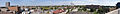
 A panoramic view of Hamilton, Ontario


Did you know? -
- ... that Doug McMurdy was the inaugural winner of the Red Tilson Trophy, given to the most outstanding player in the Ontario Hockey League each season?
Related projects and portals
Topics

Categories

Things you can do
- Help expand stub articles: There are numerous stub articles relating to Ontario. You can help by expanding them. See Ontario stubs for a list. Also, for geographical (places) stubs, refer to:
- Eastern Ontario: Eastern Ontario geography stubs
- Toronto: Toronto geography stubs
- Ottawa: Ottawa stubs - All stubs relating to Ottawa in general
- Northern Ontario: Northern Ontario geography stubs
- Western Ontario: Western Ontario geography stubs
- Golden Horseshoe: Golden Horseshoe geography stubs
Associated Wikimedia -
The following Wikimedia Foundation sister projects provide more on this subject:
-
 Commons
Free media repository -
 Wikibooks
Free textbooks and manuals -
 Wikidata
Free knowledge base -
 Wikinews
Free-content news -
 Wikiquote
Collection of quotations -
 Wikisource
Free-content library -
 Wikiversity
Free learning tools -
 Wikivoyage
Free travel guide -
 Wiktionary
Dictionary and thesaurus


![]()