
Tercan
Tercan | |
|---|---|
 The Saltukid caravanserai built in the 12th century. | |
 Map showing Tercan district in Erzincan province | |
 Tercan | |
| Coordinates: 39°46′46″N 40°23′03″E / 39.77944°N 40.38417°E | |
| Country | Turkey |
| Province | Erzincan |
| Government | |
| • Mayor | Mehmet Yılmaz (MHP) |
| • Kaymakam | Turgay Hakan Bilgin |
| Area | |
| • District | 1,545.54 km2 (596.74 sq mi) |
| Elevation | 1,425 m (4,675 ft) |
| Population | |
| • Urban | Template:Turkey district populations |
| • District | Template:Turkey district populations |
| Post code | 2553x |
| Website | www.tercan.bel.tr |
Tercan (formerly Mama Hatun, and Derzene; Template:Lang-el in the Byzantine era; Template:Lang-ku[2]) is a town and district of Erzincan Province in the Eastern Anatolia region of Turkey. The district covers an area of 1,592 km2 (615 sq mi) and its total population is 20,072 of which 6,646 live in the town of Tercan.
Located on the north bank of the Tuzla Su, a tributary of the Euphrates,[3]: 243 Tercan is especially notable for the 12th century complex of buildings built by the Saltukid female ruler Melike Mama Hatun, which comprises her tomb, a mosque, a hammam and an impressive caravanserai which was heavily restored in recent years.
History
Originally, the main town in the region of Derzene was Pekeriç.[3]: 242 Tercan superseded it in perhaps the early Ottoman period.[3]: 242 In the middle ages and early Ottoman period, two routes converged at Tercan.[3]: 242–3 The first was the one connecting Erzurum with Erzincan and Sivas.[3]: 242 The second was coming from the upper Kelkit basin via the Pekeriç plain.[3]: 242–3
The 17th century Ottoman traveller Evliya Celebi visited the place in 1647, calling it Mamahatun. He wrote about the Saltukid complex and described the town as "a Muslim village containing two hundred houses".[4]
Monuments
Caravanserai

Located just east of the town center, the caravanserai is a roughly square building arranged around a central courtyard.[3]: 243–4 There two rows of five separate rooms on the courtyard's north and south sides - these were used by better-off travelers.[3]: 243–4 These are bordered by two long rooms that take up the entire north and south sides of the building; these served as stables and sleeping quarters for most guests.[3]: 244 The monumental entrance is located on the building's east side.[3]: 243 Each side of the entryway is flanked by a vaulted recess with a raised floor; this was where guards were posted.[3]: 243 Inside the portal is an entrance hall leading to the courtyard.[3]: 243 On either side of the hall there are several rooms that were used to store merchandise.[3]: 243 A staircase leading up to the roof is on the right side.[3]: 243
At the west end of the building are three tall iwans, which are awkwardly out of place in the building's design - the builders may have copied them wholesale from another building, such as a medrese.[3]: 243 The iwans were used as places to sleep in the summer and possibly also as stables.[3]: 243 Two large rooms border the iwans, one on the north and one on the south; like the rooms by the entrance hall, these were used to store merchandise.[3]: 243
The caravanserai was changed significantly during the early Ottoman period.[3]: 243 The original design had included two porticos on the north and south sides of the courtyard, in front of the first-class rooms; these no longer exist.[3]: 245 There had also originally been six first-class rooms on each side; the two at the west end were later converted into iwans.[3]: 245
Türbe
The türbe is located in the middle of a circular courtyard surrounded by a thick wall.[3]: 245 A walkway goes around the top of the outer wall, behind a small parapet.[3]: 245 The entrance portal, which is on the southwest side, is richly decorated and is framed by a muqarnas.[3]: 245–6 The wall is raised around the portal, and the upper walkway would have originally gone through a tunnel at this point.[3]: 245 On the inside of the wall, beneath the walkway, are a series of wide arched niches.[3]: 245 These were originally designed to accommodate tombs for family members.[3]: 245 The wall above them overhangs slightly and probably represent the remains of a vaulted portico.[3]: 246 One of these niches has since been replaced with a fountain.[3]: 246 The türbe's main tower is a relatively simple structure without windows.[3]: 246 Inside, a staircase leads down to the burial chamber, which is partly below ground.[3]: 246
-
 Tomb of Melike Mama Hatun.
 -
 Entrance portal to the tomb complex.
 -
 Interior view of the walkway on top of the outer wall.
 -
 Interior of the tomb


Other nearby sights
- Kötür bridge
- Pekeriç fortress
- Abrenk (Vank) church
- Kefrenci temple
Gallery
-
 The main road running through Tercan
 -
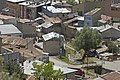
 Houses
 -
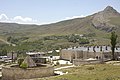
 View of Tercan
 -
 Town hall building
 -
 Street scene
 -
 View of Tercan
 -
 View of Tercan
 -
 View showing both the caravanserai and türbe
 -
 Outdoor seating area in the middle of town
 -
 View of Tercan


See also
References
- ^ "Area of regions (including lakes), km²". Regional Statistics Database. Turkish Statistical Institute. 2002. Retrieved 2013-03-05.
- ^ Adem Avcıkıran (2009). Kürtçe Anamnez Anamneza bi Kurmancî (PDF) (in Turkish and Kurdish). p. 56. Retrieved 17 December 2019.
- ^ a b c d e f g h i j k l m n o p q r s t u v w x y z aa ab ac ad Sinclair, T.A. (1989). Eastern Turkey: An Architectural & Archaeological Survey, Volume II. Pindar Press. ISBN 0-907132-33-2. Retrieved 4 September 2022.
- ^ Efendi, Evliya; Hammer (Translator), Joseph (1850). Narrative of Travels, Europe, Asia and Africa. London. p. 199.
{{cite book}}:|last2=has generic name (help)CS1 maint: location missing publisher (link)
External links
- "Mama Hatun Caravanserai, Tercan". Archnet. Archived from the original on 2006-05-25.
- "Mama Hatun Tomb, Tercan". Archnet. Archived from the original on 2007-06-10.
- Dick Osseman. "Photographs: Tercan".
Tercan in Erzincan Province of Turkey | |||||||||||||||||||||||||||
|---|---|---|---|---|---|---|---|---|---|---|---|---|---|---|---|---|---|---|---|---|---|---|---|---|---|---|---|
| Districts |   | ||||||||||||||||||||||||||
|
Metropolitan municipalities are bolded. | |||||||||||||||||||||||||||
This geographical article about a location in Erzincan Province, Turkey is a stub. You can help Wikipedia by expanding it. |