Itumirim: Difference between revisions
Appearance
Content deleted Content added
m robot Adding: it:Itumirim |
mNo edit summary |
||
| (32 intermediate revisions by 21 users not shown) | |||
| Line 1: | Line 1: | ||
{{Infobox settlement |
|||
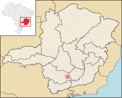
[[Image:MinasGerais Municip Itumirim.svg|thumb|right|250px|Location of Itumirim within Minas Gerais]] |
|||
| name = Itumirim |
|||
| official_name = |
|||
| settlement_type = [[Municipalities of Brazil|Municipality]] |
|||
| image_skyline = |
|||
| image_caption = |
|||
| image_flag = |
|||
| image_shield = |
|||
| nickname = |
|||
| image_map = MinasGerais Municip Itumirim.svg |
|||
| mapsize = 250px |
|||
| map_caption = Location in the state of [[Minas Gerais]] |
|||
| pushpin_map = Brazil |
|||
| pushpin_map_caption = Location in Brazil |
|||
| coordinates = {{coord|21|19|1|S|44|52|15|W|source:vowiki_region:BR|display=inline,title}} |
|||
|subdivision_type = [[List of sovereign states|Country]] |
|||
|subdivision_type1 = [[Regions of Brazil|Region]] |
|||
|subdivision_type2 = [[States of Brazil|State]] |
|||
|subdivision_type3 = [[Mesoregions of Brazil|Mesoregion]] |
|||
|subdivision_name = {{flagicon|BRA}} [[Brazil]] |
|||
|subdivision_name1 = [[Southeast Region, Brazil|Southeast]] |
|||
|subdivision_name2 = [[File:Bandeira de Minas Gerais.svg|border|22px]] [[Minas Gerais]] |
|||
|subdivision_name3 = [[Campo das Vertentes]] |
|||
| established_title = |
|||
| established_date = |
|||
| established_title2 = |
|||
| established_date2 = |
|||
| leader_party = |
|||
| leader_title = |
|||
| leader_name = |
|||
| area_total_km2 = |
|||
| area_total_sq_mi = |
|||
| elevation_m = |
|||
| elevation_ft = |
|||
| population_footnotes = |
|||
| population_total = 6,000 |
|||
| population_as_of = 2020 <ref>[https://cidades.ibge.gov.br/brasil/mg/itumirim/panorama IBGE 2020]</ref> |
|||
| population_demonym = |
|||
| timezone = [[Time in Brazil|BRT]] |
|||
| utc_offset = −3 |
|||
| timezone_DST = |
|||
| utc_offset_DST = |
|||
| postal_code_type = Postal Code |
|||
| postal_code = |
|||
| area_code = |
|||
| website = {{URL|http://www.itumirim.mg.gov.br/}} |
|||
}} |
|||
| ⚫ | |||
"Itumirim" is a term of [[Tupi language|Tupi]] origin meaning "little waterfall."<ref>{{Cite web |url=http://www.significadodosnomes.com/cidadesbrasileiras.php |title=Nomes das Cidades do Brasil |access-date=2016-09-25 |archive-url=https://web.archive.org/web/20131026105124/http://www.significadodosnomes.com/cidadesbrasileiras.php |archive-date=2013-10-26 |url-status=dead }}</ref><ref>{{cite web|url=http://www.fflch.usp.br/dlcv/tupi/vocabulario.htm |title=Curso de Tupi Antigo |access-date=2012-09-10 |url-status=dead |archive-url=https://web.archive.org/web/20120809053512/http://www.fflch.usp.br/dlcv/tupi/vocabulario.htm |archive-date=2012-08-09 }}</ref> It became a municipality by the state Decree Law No. 1058 of December 31, 1943.<ref>{{cite web |url= http://biblioteca.ibge.gov.br/visualizacao/dtbs/minasgerais/itumirim.pdf |title=Itumirim - Histórico |work=biblioteca.ibge.gov.br |year=2008 |access-date=25 June 2012}}</ref> |
|||
| ⚫ | |||
== Geography == |
|||
The municipality is in the [[Immediate Geographic Region of Lavras]], in the [[Intermediate Geographic Region of Varginha]].<ref>{{Cite web |title=Divisões Regionais do Brasil {{!}} IBGE |url=https://www.ibge.gov.br/geociencias/cartas-e-mapas/redes-geograficas/15778-divisoes-regionais-do-brasil.html |access-date=2023-02-19 |website=www.ibge.gov.br}}</ref> |
|||
=== Ecclesiastical circumscription === |
|||
The municipality is part of the [[Roman Catholic Diocese of São João del Rei|Roman Catholic Diocese of São João del-Rei]].<ref>{{Cite web |last=Silveira |first=Lucas |title=Diocese ganha novo mapa territorial após criação de novas foranias |url=https://diocesedesaojoaodelrei.com.br/diocese-ganha-novo-mapa-territorial-apos-criacao-de-novas-foranias/ |access-date=2023-02-19 |website=Diocese de São João del Rei}}</ref> |
|||
==See also== |
==See also== |
||
* [[List of municipalities in Minas Gerais (MG), Brazil|List of municipalities in Minas Gerais]] |
* [[List of municipalities in Minas Gerais (MG), Brazil|List of municipalities in Minas Gerais]] |
||
==References== |
|||
{{coord missing|Brazil}} |
|||
{{reflist}} |
|||
{{Municipalities of Minas Gerais}} |
|||
| ⚫ | |||
| ⚫ | |||
| ⚫ | |||
| ⚫ | |||
| ⚫ | |||
| ⚫ | |||
[[eo:Itumirim]] |
|||
[[bpy:ইটুমিরিম]] |
|||
[[it:Itumirim]] |
|||
[[no:Itumirim]] |
|||
[[pt:Itumirim]] |
|||
[[ro:Itumirim]] |
|||
[[ru:Итумирин]] |
|||
[[vo:Itumirim]] |
|||
Revision as of 02:46, 19 February 2023
Itumirim | |
|---|---|
 Location in the state of Minas Gerais | |
| Coordinates: 21°19′1″S 44°52′15″W / 21.31694°S 44.87083°W | |
| Country | |
| Region | Southeast |
| State | |
| Mesoregion | Campo das Vertentes |
| Population (2020 [1]) | |
| • Total | 6,000 |
| Time zone | UTC−3 (BRT) |
| Website | www |
Itumirim is a Brazilian municipality located in the state of Minas Gerais. The city belongs to the mesoregion of Campo das Vertentes and to the microregion of Lavras. As of 2020[update] it has a population of 6,000.
"Itumirim" is a term of Tupi origin meaning "little waterfall."[2][3] It became a municipality by the state Decree Law No. 1058 of December 31, 1943.[4]
Geography
The municipality is in the Immediate Geographic Region of Lavras, in the Intermediate Geographic Region of Varginha.[5]
Ecclesiastical circumscription
The municipality is part of the Roman Catholic Diocese of São João del-Rei.[6]
See also
References
- ^ IBGE 2020
- ^ "Nomes das Cidades do Brasil". Archived from the original on 2013-10-26. Retrieved 2016-09-25.
- ^ "Curso de Tupi Antigo". Archived from the original on 2012-08-09. Retrieved 2012-09-10.
- ^ "Itumirim - Histórico" (PDF). biblioteca.ibge.gov.br. 2008. Retrieved 25 June 2012.
- ^ "Divisões Regionais do Brasil | IBGE". www.ibge.gov.br. Retrieved 2023-02-19.
- ^ Silveira, Lucas. "Diocese ganha novo mapa territorial após criação de novas foranias". Diocese de São João del Rei. Retrieved 2023-02-19.


