
Montclair, New Jersey: Difference between revisions
clean up and general fixes, using AWB |
|||
| Line 265: | Line 265: | ||
{{Montclair Parks, New Jersey}} |
{{Montclair Parks, New Jersey}} |
||
==Media== |
[http://www.example.com link title]==Media== |
||
{{Unreferenced section|date=December 2008}} |
{{Unreferenced section|date=December 2008}} |
||
Montclair has its own local newspaper, the ''Montclair Times''. In addition, there is a radio station on the campus of [[Montclair State University]], [[WMSC]]. [[Montclair State University]] is also the major broadcasting site for [[New Jersey Network]] in [[North Jersey|Northern New Jersey]]. Locals also subscribe to ''[[The Star-Ledger]]'' of [[Newark, New Jersey]], and ''[[The New York Times]]''. The township has a municipal public service television channel, Channel 34, where town council meetings and school board meetings are broadcast. [[Montclair High School (New Jersey)|Montclair High School]] has its own paper ''the Mountaineer'', and [[Montclair State University]] has its own student-run paper, the ''Montclarion''. The [[Montclair Kimberley Academy]] has a student-run newspaper entitled ''The Academy News'' which reached its height under the dedicated leadership of Eli Bildner, Ari Bildner, Nick David, Ian David, and Will Wagner. Montclair also has a community blog network, [http://www.baristanet.com/ baristanet]. |
Montclair has its own local newspaper, the [http://www.montclairtimes.com ''Montclair Times'']. In addition, there is a radio station on the campus of [[Montclair State University]], [[WMSC]]. [[Montclair State University]] is also the major broadcasting site for [[New Jersey Network]] in [[North Jersey|Northern New Jersey]]. Locals also subscribe to ''[[The Star-Ledger]]'' of [[Newark, New Jersey]], and ''[[The New York Times]]''. The township has a municipal public service television channel, Channel 34, where town council meetings and school board meetings are broadcast. [[Montclair High School (New Jersey)|Montclair High School]] has its own paper ''the Mountaineer'', and [[Montclair State University]] has its own student-run paper, the ''Montclarion''. The [[Montclair Kimberley Academy]] has a student-run newspaper entitled ''The Academy News'' which reached its height under the dedicated leadership of Eli Bildner, Ari Bildner, Nick David, Ian David, and Will Wagner. Montclair also has a community blog network, [http://www.baristanet.com/ baristanet]. |
||
''Laco Nation'', school newspaper of Upper Montclair's Lacordaire Academy, has released five issues in the 2008-2009 school year for the first time in four years. |
''Laco Nation'', school newspaper of Upper Montclair's Lacordaire Academy, has released five issues in the 2008-2009 school year for the first time in four years. |
||
Revision as of 16:21, 3 February 2010
Montclair, New Jersey | |
|---|---|
 | |
|
Seal | |
 Map of Montclair in Essex County. Inset: Location of Montclair highlighted in the State of New Jersey. | |
 Census Bureau map of Montclair, New Jersey | |
| Country | United States |
| State | New Jersey |
| County | Essex |
| Incorporated | April 15, 1868 |
| Government | |
| • Type | Faulkner Act (Council-Manager) |
| • Mayor | Jerry Fried |
| • Manager | Joseph M. Hartnett[1] |
| Area | |
| • Total | 6.3 sq mi (16.3 km2) |
| • Land | 6.3 sq mi (16.3 km2) |
| • Water | 0.0 sq mi (0.0 km2) |
| Elevation | 302 ft (92 m) |
| Population (2008)[4] | |
| • Total | 36,966 |
| • Density | 6,073/sq mi (2,387.5/km2) |
| Time zone | UTC-5 (Eastern (EST)) |
| • Summer (DST) | UTC-4 (EDT) |
| ZIP codes | 07042-07043 |
| Area code | 973 |
| FIPS code | 34-47500Template:GR[5] |
| GNIS feature ID | 1729720Template:GR |
| Website | http://www.montclairnjusa.org/ |
Montclair (Template:Pron-en or /mɒŋˈklɛər/) is a township in Essex County, New Jersey, United States. It is the 50th largest municipality in New Jersey by population. As of the United States 2000 Census, the township population was 38,977.
Montclair was first formed as a Township on April 15, 1868, from portions of Bloomfield Township[6], so that a railroad could be built to Montclair. After a referendum held on February 21, 1894, Montclair was reincorporated as a Town, effective February 24, 1894.[7] In the late 1970s, after protesting for years at the inequities built into the formulas, Montclair joined several other communities to qualify for a pool of federal aid allocated only to Townships, that allowed townships to receive as much as double the revenue-sharing aid per capita received by the four other types of New Jersey municipalities — Borough, City, Town or Village.[8][9]
Climate
Montclair has a temperate climate, with warm/hot humid summers and cool/cold winters, according to the Köppen climate classification humid subtropical climate. January tends to be the coldest month, with average high temperatures in the upper 30's and lows averaging 21. July is the warmest months with high temperatures in the mid 80s and lows in the 70's, the average high is at 86 Fahrenheit. From April to June and from September to early November, Montclair experiences temperatures from the lower 60s to the lower 70s.
Montclair, NJ, gets on average 44 inches (1100 mm) of rain per year, above the US average of 37 inches. Snowfall is common from December to early March, at about 30 inches annually. The number of days each year in Montclair with any measurable precipitation is 90, and an average of 202 sunny days.
Montclair is one or two degrees warmer than the neighboring towns of Verona and Cedar Grove because of the mountain between them, which sometimes blocks winds and clouds, including warmer air from the ocean to the east.
Geography
Neighboring towns. | ||||||||||||||||
|---|---|---|---|---|---|---|---|---|---|---|---|---|---|---|---|---|
| ||||||||||||||||
Montclair is located at 40°49′20″N 74°12′43″W / 40.822249°N 74.211989°W (40.822249, -74.211989).Template:GR
According to the United States Census Bureau, the township has a total area of 6.3 square miles (16.3 km2).
Montclair is located on the First Mountain of the Watchung Mountains. Most of the town is on the eastward-side of this ridge. Thus, many locations provide excellent views of the surrounding area and the New York City skyline, which is about 12 miles (19 km) away. Since the formation of Montclair, the western border on that mountain with Verona, West Orange, and Cedar Grove has moved slightly eastward, making the town slightly smaller.
Montclair is assigned two ZIP codes, the central and southern parts of the town are designated 07042. The northern portion of town, north of Watchung Avenue, has a separate ZIP code, 07043, and is known as Upper Montclair. Because the ZIP codes do not exactly match municipal boundaries, a few homes near the borders with neighbouring towns fall into the ZIP codes for those towns (likewise, a few homes in some adjoining towns use one of the two ZIP codes assigned to Montclair)[citation needed]. Small areas in the southeast of town fall into the Glen Ridge ZIP code, 07028
Several streams flow eastward through Montclair: Toney's Brook in the center, Nishuane Brook in the southeast, the Wigwam Brook in the southwest, the Pearl Brook in the northwest, and the Yantacaw Brook in the northeast, all in the Passaic River watershed. The Yantacaw and Toney's brooks are dammed in parks to create ponds. The Wigwam, Nishuane, and Toney's brook flow into the Second River, and the others flow into the Third River. Formerly, north of Bloomfield Avenue between Grove Street and Pine Street there was another dam and another pond, powering a factory. Montclair is just north of the northern border of the Rahway River watershed.

The Southern border of Montclair is a straight line between the Eagle Rock, on the ridge of the First Watchung Mountain, and the point where Orange Road crosses the Nishuane Brook. The western border is roughly along the ridge of the First Watchung Mountain between the Eagle Rock and the Essex County/Passaic County Border. The northern border is the same as the border between those two counties.
Demographics
| Census | Pop. | Note | %± |
|---|---|---|---|
| 1830 | less than 1,400 | — | |
| 1870 | 2,853 | — | |
| 1880 | 5,147 | 80.4% | |
| 1910 | 21,559 | — | |
| 1920 | 28,772 | 33.5% | |
| 1930 | 42,017 | 46.0% | |
| 1940 | 39,807 | −5.3% | |
| 1950 | 43,927 | 10.3% | |
| 1960 | 43,129 | −1.8% | |
| 1970 | 44,043 | 2.1% | |
| 1980 | 38,321 | −13.0% | |
| 1990 | 37,729 | −1.5% | |
| 2000 | 38,977 | 3.3% | |
| 2008 (est.) | 36,966 | [4][10][11] | |
| Population 1930 - 1990.[12][13] 1830 data.[14] | |||
As of the censusTemplate:GR of 2000, there were 38,977 people, 15,020 households, and 9,687 families residing in the township. The population density was 6,183.6 people per square mile (2,388.7/km2). There were 15,531 housing units at an average density of 2,464.0/sq mi (951.8/km2). The racial makeup of the CDP was 59.77% White, 32.06% African American, 0.19% Native American, 3.15% Asian, 0.04% Pacific Islander, 1.77% from other races, and 3.03% from two or more races. Hispanic or Latino of any race were 5.12% of the population. Montclair has long highlighted its diversity, a feature that has attracted many to the community.[15]
There were 15,020 households out of which 34.3% had children under the age of 18 living with them, 47.2% were married couples living together, 14.1% had a female householder with no husband present, and 35.5% were non-families. 29.3% of all households were made up of individuals and 8.6% had someone living alone who was 65 years of age or older. The average household size was 2.53 and the average family size was 3.16.
In the township the population was spread out with 25.6% under the age of 18, 6.6% from 18 to 24, 31.9% from 25 to 44, 24.1% from 45 to 64, and 12.0% who were 65 years of age or older. The median age was 38 years. For every 100 females there were 86.3 males. For every 100 females age 18 and over, there were 80.7 males.
According to a 2007 estimate,[16] the median income for a household in the township was $92,988, and the median income for a family was $119,850. Males had a median income of $64,151 versus $43,520 for females. The per capita income for the township was $44,870. About 3.9% of families and 5.6% of the population were below the poverty line, including 5.4% of those under age 18 and 7.2% of those age 65 or over.
As of 2007, 56.95% of Montclair residents affiliate with a religion. 43.05% of Montclair is nonreligious, 35.29% of the population are Catholic; 9.60% in Montclair are Jewish; 2.74% affiliate with Islam; 9.3% are with another Christian sect.; with a small percentages of others.[17] Proportionally, there are more Muslims, Jews, and Catholics than the country's average.
Montclair has attracted many who work for major media organizations in New York City, including The New York Times and Newsweek. A March 11, 2007, posting in the blog Gawker.com listed some of those who work in the media and live in Montclair.[18] In it also live many commuters to New York City and the Metro Area.
Government
.jpg)
Local government
Montclair is governed under the Council-Manager form of municipal government under the Faulkner Act, whose originator was a former mayor of Montclair. The government consists of a mayor and a six-member Township Council. The mayor and council are all elected to four-year terms in nonpartisan elections on a concurrent basis. The mayor and two council seats are elected at-large, with four council seats elected from each of four wards.[2]
Though the Mayor has no executive powers, the Mayor presides over council meetings and has both a voice and vote in its proceedings. The Mayor appoints the trustees of the public library and the members of the board of education.[19]
Members of the Montclair Township Council are:[20]
- Mayor Jerry Fried
- Deputy Mayor Roger S. Terry
- Councilor-At-Large Kathryn Weller
- 1st Ward Councilor Rich Murnick
- 2nd Ward Councilor Cary Africk
- 3rd Ward Councilor Nick Lewis
- 4th Ward Councilor Renée E. Baskerville, M.D.
In elections held on May 13, 2008, Jerry Fried won election as mayor, defeating councilmembers Joyce Michaelson and Ted Mattox. Fried's Unity Montclair running mates also won office, with Kathryn Weller taking one of the at-large seats, Cary Africk winning the 2nd Ward and Nick Lewis taking the 3rd Ward. Partnership Montclair's Roger Terry won an at-large seat and Rich Murnick won in the 1st Ward. The new council takes office on July 1, 2008. The 4th ward was won by Dr. Renée Baskerville, who ran as an independent.[21]
Federal, state and county representation

Montclair is split between the Eighth Congressional District in the north and Tenth Congressional District in the south. It is part of New Jersey's 34th Legislative District.[22]
For the 118th United States Congress, New Jersey's 8th congressional district is represented by Rob Menendez (D, Jersey City).[23][24] For the 118th United States Congress, New Jersey's 10th congressional district is represented by Donald Payne Jr. (D, Newark).[25][26] New Jersey is represented in the United States Senate by Democrats Cory Booker (Newark, term ends 2027)[27] and George Helmy (Mountain Lakes, term ends 2024), who was appointed to the seat following the resignation of Bob Menendez (Englewood Cliffs).[28][29]
For the 2024-2025 session, the 34th legislative district of the New Jersey Legislature is represented in the State Senate by Britnee Timberlake (D, East Orange) and in the General Assembly by Carmen Morales (D, Belleville) and Michael Venezia (D, Bloomfield).[30] Template:NJ Governor
Essex County is governed by a directly elected county executive, with legislative functions performed by the Board of County Commissioners. As of 2024[update], the County Executive is Joseph N. DiVincenzo Jr. (D, Roseland), whose four-year term of office ends December 31, 2026.[31] The county's Board of County Commissioners is composed of nine members, five of whom are elected from districts and four of whom are elected on an at-large basis. They are elected for three-year concurrent terms and may be re-elected to successive terms at the annual election in November.[32] Essex County's Commissioners are:
Robert Mercado (D, District 1 – Newark's North and East Wards, parts of Central and West Wards; Newark, 2026),[33] A'Dorian Murray-Thomas (D, District 2 – Irvington, Maplewood and parts of Newark's South and West Wards; Newark, 2026),[34] Vice President Tyshammie L. Cooper (D, District 3 - Newark: West and Central Wards; East Orange, Orange and South Orange; East Orange, 2026),[35] Leonard M. Luciano (D, District 4 – Caldwell, Cedar Grove, Essex Fells, Fairfield, Livingston, Millburn, North Caldwell, Roseland, Verona, West Caldwell and West Orange; West Caldwell, 2026),[36] President Carlos M. Pomares (D, District 5 – Belleville, Bloomfield, Glen Ridge, Montclair and Nutley; Bloomfield, 2026),[37] Brendan W. Gill (D, at large; Montclair, 2026),[38] Romaine Graham (D, at large; Irvington, 2026),[39] Wayne Richardson (D, at large; Newark, 2026),[40] Patricia Sebold (D, at-large; Livingston, 2026).[41][42][43][44][45]
Constitutional officers elected countywide are: Clerk Christopher J. Durkin (D, West Caldwell, 2025),[46][47] Register of Deeds Juan M. Rivera Jr. (D, Newark, 2025),[48][49] Sheriff Armando B. Fontoura (D, Fairfield, 2024),[50][51] and Surrogate Alturrick Kenney (D, Newark, 2028).[52][53]
Politics
On the national level, Montclair leans strongly toward the Democratic Party. In 2008, Democrat Barack Obama received 83% of the vote here, defeating Republican John McCain. About 70% of people in Montclair are Democrats.[citation needed]
Arts
.jpg)
Montclair is home to many art institutions and theaters. For its relatively small size, Montclair has more art venues than one could expect. It has its own art museum, the Montclair Art Museum and several small galleries. Montclair also hosts two theaters that showcase movies and films, both originally live theaters, having been later converted. Clearview Cinemas has two locations in Montclair, the Bellevue Theater located in Upper Montclair and the Clairidge Cinema, located on Bloomfield Avenue. While the Bellevue Cinema mostly shows main-stream Hollywood films, the Clairidge Cinema shows different types of movies from documentaries to small scale indy films. Live theaters include, but are not limited to, The Montclair Opretta Company, the Wellmont Theatre, Montclair State University's Kasser Theater, Montclair State University's theater in Life Hall, and the Studio Playhouse. On Bloomfield Avenue there is a public stage used for concerts and other events. Dotted around Montclair there are also many art galleries, though most are centered in the Bloomfield Avenue Downtown Area.[54][55] Live music is presented at the Wellmont Theater, Outpost in the Burbs, and Trumpets jazz club. Free musical performances are also presented at an outdoor stage at the corner of Church Street and Bloomfield Avenue in the summer.
Commerce
Montclair has 6 distinct commercial zones, each spread out around the town

The Main Commercial Zones in Montclair are:
- Montclair Center is centered on the intersection of Bloomfield Avenue, South Fullerton Avenue, Glen Ridge Avenue and Church Street. This intersection is also known as Six Corners. Montclair Center is the main commercial zone of Montclair and has the largest stores such as furniture stores and large restaurants which are more upscale near the center, which has many restaurants and boutiques. Near the eastern end of this business area is Lackawanna Plaza, a shopping center with about ten stores built inside an old railway station. There is a post office one block to the north of this place.
- Upper Montclair in the North of the town, the second largest commercial zone. The center is the intersection of Valley Road and Bellevue Avenue, with surrounding areas as well. The Upper Montclair Business District is home to several restaurants and shops. Unlike many of Montclair's other commercial zones, it has chain stores like Starbucks, Talbots, Williams-Sonoma, Gap, Charlie Browns, Cold Stone Creamery, Supercuts, CVS and smaller chains such as Tinga. It also has both a park, Anderson Park, and a railway station, Upper Montclair, nearby. There is a post office here.
- Watchung Plaza, around the intersection of Watchung Avenue and Park Street. It is home to many "Mom and Pop Stores" and other small businesses and is located on the divide Montclair's two ZIP Codes, 07042 and 07043. Watchung Plaza has its own post office.
- Walnut Street, built around the Walnut Street train station. In the Spring, Summer, and Fall it is home to the Montclair Farmer's Market.
- South End, in the south of town, at the intersection of Cedar Avenue and Orange Road.
- Valley Road between Chestnut Street and Claremont Avenue. Known locally as Frog Hollow, this area has some strip mall style shops on one side of Valley Road and on the other side are window shops with residential apartments on top of them.
Transportation
New Jersey Transit and DeCamp Bus Lines are the providers of public transportation in Montclair. Montclair is considered a commuter town of New York City. The average Montclair Commute is 38 minutes each way. 24% of commuters travelers take mass transit, while 59% drive alone. Twelve times more Montclair commuters travelers take mass transit than the national average.[56]
Bus
NJ Transit buses 11, 28, 29, 34, 97, 191 and 705 run through Montclair, most going along the main street, Bloomfield Avenue. The New Jersey transit bus routes are:
- #11 goes from Downtown Newark through Verona, Cedar Grove, and Little Falls to Willowbrook Mall in Wayne. The only Montclair street it goes along is Bloomfield Avenue.
- #28 follows the route of #29 on Bloomfield Avenue until halfway through Montclair, where it goes north along Park Street, Watchung Avenue, and Valley Road to Montclair State University, and to Willowbrook Mall on Weekends
- #29 between West Caldwell and Newark, passing through Caldwell, Verona, Montclair, Glen Ridge, and Bloomfield on Bloomfield Avenue. It goes to Parsippany at rush hour. The only Montclair street it goes along is Bloomfield Avenue.
- #34 to Newark through East Orange and Orange on some trips, otherwise it goes to Bloomfield.. The Streets it goes on are Orange Road, Elm Street, and Bloomfield Avenue. It goes farther to the Montclair High School during that school's start and end times.
- #97 goes from the Montclair Center south along Orange and Harrison Roads through the Oranges.
- #191 goes from Willowbrook Mall through Little Falls to Montclair State University, then to New York City.
- #705 goes from Passaic along Alexander Road, Mt. Hebron Road and through Montclair State University to Willowbrook Mall
All of these routes except #97, #191, and #705 were trolley lines originally, operated by the Public Service Railway. A trolley Garage existed on Bloomfield Avenue. In the 1930s and 1950s the trolleys were destroyed and replaced with buses.
DeCamp Bus Lines routes 33 and 66 run through Montclair to the Port Authority Bus Terminal in New York City, Carrying primarily commuters.
- #33 goes along Bloomfield Avenue, with some buses going onto Grove Street
- #66 goes along Orange Road, Park Street, Valley Road, and Mt. Hebron Road
Montclair State University has Shuttle buses going around its campus.
The township of Montclair operates a jitney in the evening from the Bay Street train station to the southern end of Montclair.
Rail
Running through Montclair is the Montclair-Boonton Line, which goes between New York City / Hoboken and Hackettstown. There are seven railway stations in Montclair: Bay Street, Walnut Street, Watchung Avenue, Upper Montclair, Mountain Avenue, and Montclair Heights, and Montclair State University. Only Bay Street station has weekend train service. Montclair has a long history of railroads. The first railroad was built to Montclair in 1856 by the Newark and Bloomfield Railroad. It terminated at a station in Downtown Montclair. First the Morris and Essex Railroad, then the Delaware, Lackawanna and Western Railroad leased the line. In 1868 The Montclair Railway built another line through Montclair, which caused disputes leading to Montclair's separation from Bloomfield. Shortly afterward it was taken over by the New York and Greenwood Lake Railway, a subsidiary of the Erie Railroad. A third Railroad to Morristown was planned in 1860 and construction began, but an economic collapse in 1873 ended the building. In 1912 the Lackawanna Railroad built a large terminal at the end of their line, but it was closed in 1981 and converted into shops. After the two railroads merged and went bankrupt, NJ Transit took over passenger operations. In 2002 the two railways were connected with the construction of the Montclair Connection.
Air and Road
Montclair is 13 miles (21 km) from Newark Liberty International Airport, 42 miles (68 km) from JFK Airport and 31 miles (50 km) from LaGuardia Airport. The Garden State Parkway and U.S. Route 46 are slightly past the town's borders. The main road through Montclair is Bloomfield Avenue.
There is a taxi stand off of Bloomfield Avenue in eastern Montclair, in front of Lackawanna Plaza, formerly the Montclair train station.
Housing
The median price for a house in Montclair is $670,400, more than three times the national average. The cost of living is also 48.37% percent higher than the USA's average. The median age of a house in Montclair is 51 years old.[citation needed]
Montclair is noted for its historic architecture. It is home to six historic districts listed on the Register of Historic Places of both the state and country as a whole, 92 individually listed landmarks, and two locally designated commercial districts. Works by significant architects include designs by Van Vleck and Goldsmith, Charles Follen McKim, McKim, Mead, and White, Henry Hudson Holly, Charles A. Platt, Alexander Jackson Davis, Dudley Van Antwerp, Effingham R. North, and Frances Nelson, among others.[citation needed]
Education
.jpg)
The Montclair Public Schools serve students in pre-school through twelfth grade. Montclair's public school system spends $9,571 per student, with the national average being about $6000. The schools employ one faculty member for each 14 children it teaches. Schools in the district (with 2005-06 enrollment data from the National Center for Education Statistics[57]) are seven elementary schools (K-5, except as noted) —
Bradford (427 students), Edgemont (306), Hillside (643, grades 3-5), Nishuane (586, grades K-2), Northeast (405), Rand (382) and Watchung (425) — Three middle schools for grades 6-8 — Glenfield (670), Mount Hebron (612) and Renaissance (238) — and Montclair High School for grades 9-12 (1,958).
Montclair is home to Montclair State University.
Montclair is also home to a host of private and parochial schools, including: Montclair Kimberley Academy, Lacordaire Academy, Immaculate Conception High School, St. Cassian's School, Virginia Harkness Sawtelle Learning, Maria Montessori Early Learning, Montclair Cooperative School, Trinity Academy, and Deron School II.
Parks


Montclair is home to many parks and nature reserves.
In Montclair there are many parks, such as Edgemont Memorial Park, Essex Park, Glenfield Park, Nishuane Park, Rand Park, Graz Park, Canterbury Park, Watchung Park, Eagle Rock Reservation, Brookdale Park, Anderson Park, Yantacaw Brook Park the Bonsal Nature Reserve, Mountainside Park, the Presby Memorial Iris Gardens, and Mills Reservation. There are also many sports fields, some public, like in the parks, or some school owned, like the Essex Park fields or Montclair State University's Sprague Field. In total Montclair has 153.86 acres (0.6226 km2) of township park land spread around 18 parks and 123.76 acres (0.5008 km2) of county park land consisting of five parks.[58]
There are also 18 public tennis courts, four skating rinks (two of which are indoor) and 3 public swimming pools, which are the Mountainside pool, the Nishuane pool, and the Essex pool.[59]
| County parks | | |
|---|---|---|
| Town parks | ||
| Reservations | ||
| Other facilities | ||
link title==Media==
Montclair has its own local newspaper, the Montclair Times. In addition, there is a radio station on the campus of Montclair State University, WMSC. Montclair State University is also the major broadcasting site for New Jersey Network in Northern New Jersey. Locals also subscribe to The Star-Ledger of Newark, New Jersey, and The New York Times. The township has a municipal public service television channel, Channel 34, where town council meetings and school board meetings are broadcast. Montclair High School has its own paper the Mountaineer, and Montclair State University has its own student-run paper, the Montclarion. The Montclair Kimberley Academy has a student-run newspaper entitled The Academy News which reached its height under the dedicated leadership of Eli Bildner, Ari Bildner, Nick David, Ian David, and Will Wagner. Montclair also has a community blog network, baristanet. Laco Nation, school newspaper of Upper Montclair's Lacordaire Academy, has released five issues in the 2008-2009 school year for the first time in four years.
Sports
- Home to the Montclair Rugby Club, also known as the Norsemen, of USA Rugby Division 2. They play at Codey Field.
- Home to the Minor league baseball New Jersey Jackals of the Can-Am League. The Jackals play at Yogi Berra Stadium.
- Montclair is home to Essex Eagles Cricket Team, which is Division III team in the Cricket League of New Jersey.
- Former home to the New Jersey Pride of Major League Lacrosse.
- Home to the 2008 Under-12 Championship Softball Team Montclair Magic
- Home to Floyd Hall Arena, an Ice Rink which is actually located in Little Falls but lays on the grounds of Montclair State University and is host to its Ice Hockey club. Various other hockey leagues, teams and on ice sports take part there as well.
Sister cities
Montclair is twinned with the following cities:[60]
 Laguna de Perlas (Pearl Lagoon), Nicaragua[63]
Points of interest

- Montclair Art Museum
- Howard Van Vleck Arboretum
- Presby Memorial Iris Gardens
- Van Vleck House and Gardens
- Crane House and Museum
- The Montclair Historical Society, which consists of:
- Nathaniel Crane House
- Clark House
- Evergreens (House)
- Yogi Berra Stadium, Museum and Learning Center
- Parks and dining in Upper Montclair
- Shopping on Bloomfield Avenue and on Church Street[citation needed]
Gallery
- Montclair Gallery
-
 Icon of Montclair, WWI Memorial in Edgemont Memorial Park
 -
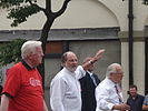 Governor of New Jersey, Jon Corzine, walking down Bloomfield Avenue
 -
Business district in Upper Montclair, which is around the intersection of Valley Road and Bellevue Avenue
-
 Montclair Public Library
 -
 Bloomfield Avenue business district
 -

-
 Watchung Plaza
 -
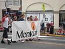 Montclair's banner held by exchange students from Montclair's sister city, Graz, Austria
 -
 Mountainside Hospital, (Which is located just across the border in Glen Ridge)
 -
 the South End area of Montclair
 -
 A political march in Montclair


.jpg)
_on_the_United_World_Charts.jpg)
.jpg)


Notable residents
References
- ^ Township Manager, Township of Montclair. Accessed July 14, 2008.
- ^ a b 2005 New Jersey Legislative District Data Book, Rutgers University Edward J. Bloustein School of Planning and Public Policy, April 2005, p. 148.
- ^ U.S. Geological Survey Geographic Names Information System: Township of Montclair, Geographic Names Information System, accessed October 23, 2007.
- ^ a b Census data for Montclair township, United States Census Bureau. Accessed August 27, 2009.
- ^ A Cure for the Common Codes: New Jersey, Missouri Census Data Center. Accessed July 14, 2008.
- ^ History of Montclair, Montclair Township. Accessed August 5, 2007. "When Bloomfield authorities declined to authorize a bond issue to underwrite another railroad, Montclair residents were successful in securing from the State legislature a charter for a separate township. Thus in 1868, the Township of Montclair was created."
- ^ "The Story of New Jersey's Civil Boundaries: 1606-1968", John P. Snyder, Bureau of Geology and Topography; Trenton, New Jersey; 1969. p. 129.
- ^ "Opponent of Distribution Formula For Federal Aid Steps Up Attack; As South Orange Moves to Become Township, Montclair Aide Calls for Equitable Sharing", The New York Times August 29, 1977. p. 59.
- ^ History of Montclair, accessed January 1, 2007.
- ^ The Montclair Historical Society | History of Montclair
- ^ Reminiscences of Montclair, New Jersey
- ^ New Jersey Resident Population by Municipality: 1930 - 1990, Workforce New Jersey Public Information Network. Accessed March 1, 2007.
- ^ http://www.firstbaptistbloomfield.org/knox-hist.htm
- ^ Montclair Historical Society
- ^ Goodnough, Abby. " SCHOOLS: REFERENDUM;How to Pick the School Board?", The New York Times, October 22, 1995. Accessed July 14, 2008. "In a town that has always been proud of its diversity -- many residents say it was their primary reason for moving to Montclair -- the difference of opinion has caused considerable strife."
- ^ http://factfinder.census.gov/servlet/ACSSAFFFacts?_event=ChangeGeoContext&geo_id=06000US3401347500&_geoContext=01000US%7C04000US34%7C05000US34013%7C06000US3401343800&_street=&_county=montclair&_cityTown=montclair&_state=04000US34&_zip=&_lang=en&_sse=on&ActiveGeoDiv=geoSelect&_useEV=&pctxt=fph&pgsl=010&_submenuId=factsheet_1&ds_name=ACS_2007_3YR_SAFF&_ci_nbr=null&qr_name=null®=null%3Anull&_keyword=&_industry=
- ^ http://www.bestplaces.net/city/Montclair-New_Jersey.aspx Best Places city data. accessed September 2008
- ^ Where They Weekend: Montclair, NJ, Gawker.com, March 11, 2007. Accessed July 3, 2007.
- ^ Montclair's Form of Government, Montclair Township. Accessed June 27, 2006.
- ^ Montclair Township Government, Montclair Township. Accessed July 7, 2008.
- ^ Zarra, Erica. "Fried finishes first", Montclair Times, May 16, 2008. Accessed June 4, 2008.
- ^ 2008 New Jersey Citizen's Guide to Government, New Jersey League of Women Voters, p. 60. Accessed September 30, 2009.
- ^ Directory of Representatives: New Jersey, United States House of Representatives. Accessed January 3, 2019.
- ^ Biography, Congressman Albio Sires. Accessed January 3, 2019. "Congressman Sires resides in West New York with his wife, Adrienne."
- ^ Directory of Representatives: New Jersey, United States House of Representatives. Accessed January 3, 2019.
- ^ Biography, Congressman Donald M. Payne Jr. Accessed January 3, 2019. "U.S. Representative Donald M. Payne, Jr. is a lifelong resident of Newark, New Jersey."
- ^ U.S. Sen. Cory Booker cruises past Republican challenger Rik Mehta in New Jersey, PhillyVoice. Accessed April 30, 2021. "He now owns a home and lives in Newark's Central Ward community."
- ^ https://www.nytimes.com/2024/08/23/nyregion/george-helmy-bob-menendez-murphy.html
- ^ Tully, Tracey (August 23, 2024). "Menendez's Senate Replacement Has Been a Democrat for Just 5 Months". The New York Times. Retrieved August 23, 2024.
- ^ Legislative Roster for District 34, New Jersey Legislature. Accessed January 20, 2024.
- ^ Essex County Executive, Essex County, New Jersey. Accessed July 20, 2020.
- ^ General Information, Essex County, New Jersey. Accessed July 20, 2020. "The County Executive, elected from the County at-large, for a four-year term, is the chief political and administrative officer of the County.... The Board of Chosen Freeholders consists of nine members, five of whom are elected from districts and four of whom are elected at-large. They are elected for three-year concurrent terms and may be re-elected to successive terms at the annual election in November. There is no limit to the number of terms they may serve."
- ^ Robert Mercado, Commissioner, District 1, Essex County, New Jersey. Accessed July 20, 2020.
- ^ Wayne L. Richardson, Commissioner President, District 2, Essex County, New Jersey. Accessed July 20, 2020.
- ^ Tyshammie L. Cooper, Commissioner, District 3, Essex County, New Jersey. Accessed July 20, 2020.
- ^ Leonard M. Luciano, Commissioner, District 4, Essex County, New Jersey. Accessed July 20, 2020.
- ^ Carlos M. Pomares, Commissioner Vice President, District 5, Essex County, New Jersey. Accessed July 20, 2020.
- ^ Brendan W. Gill, Commissioner At-large, Essex County, New Jersey. Accessed July 20, 2020.
- ^ Romaine Graham, Commissioner At-large, Essex County, New Jersey. Accessed July 20, 2020.
- ^ Newark Native Elected As County Commissioner: A'Dorian Murray-Thomas, Patch. Accessed January 10, 2024.
- ^ Patricia Sebold, Commissioner At-large, Essex County, New Jersey. Accessed July 20, 2020.
- ^ Members of the Essex County Board of County Commissioners, Essex County, New Jersey. Accessed July 20, 2020.
- ^ Breakdown of County Commissioners Districts, Essex County, New Jersey. Accessed July 20, 2020.
- ^ 2021 County Data Sheet, Essex County, New Jersey. Accessed July 20, 2022.
- ^ County Directory, Essex County, New Jersey. Accessed July 20, 2022.
- ^ About The Clerk, Essex County Clerk. Accessed July 20, 2020.
- ^ Members List: Clerks, Constitutional Officers Association of New Jersey. Accessed July 20, 2020.
- ^ About the Register, Essex County Register of Deeds and Mortgages. Accessed July 20, 2022.
- ^ Members List: Registers, Constitutional Officers Association of New Jersey. Accessed July 20, 2020.
- ^ Armando B. Fontura, Essex County Sheriff's Office. Accessed June 10, 2018.
- ^ Members List: Sheriffs, Constitutional Officers Association of New Jersey. Accessed July 20, 2020.
- ^ The Essex County Surrogate's Office, Essex County Surrogate. Accessed July 20, 2020.
- ^ Members List: Surrogates, Constitutional Officers Association of New Jersey. Accessed July 20, 2020.
- ^ [1]September 3, 2009.
- ^ [2]September 3, 2009.
- ^ http://factfinder.census.gov/servlet/NPTable?_bm=y&-qr_name=ACS_2007_3YR_G00_NP01&-geo_id=06000US3401347500&-gc_url=&-ds_name=&-_lang=en
- ^ Data for the Montclair Public Schools, National Center for Education Statistics. Accessed April 1, 2008.
- ^ List of parks http://www.gotomontclairnj.com/parks.htm
- ^ Montclair Information, Township of Montclair. Accessed July 4, 2008.
- ^ Online Directory: New Jersey, USA, Sister Cities International. Accessed November 8, 2007.
- ^ Sister City Exchange With Barnet, England, accessed September 12, 2006.
- ^ "Twin Towns - Graz Online - English Version". www.graz.at. Retrieved 2010-01-05.
- ^ Nicaragua Sister City projects
External links
- Township of Montclair Official Website
- Montclair Business Improvement District
- Montclair Historical Society
Municipalities and communities of Essex County, New Jersey, United States | ||
|---|---|---|
| Cities |  | |
| Boroughs | ||
| Townships | ||
| CDPs | ||
| Other communities | ||
| Footnotes | ‡This populated place also has portions in an adjacent county or counties | |