Golden Plains Shire: Difference between revisions
Appearance
Content deleted Content added
m Bot: Migrating 4 interwiki links, now provided by Wikidata on d:q1338860 (Report Errors) |
No edit summary |
||
| Line 25: | Line 25: | ||
| near-se = [[Surf Coast Shire|Surf Coast]] |
| near-se = [[Surf Coast Shire|Surf Coast]] |
||
}} |
}} |
||
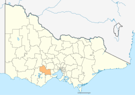
'''Golden Plains Shire''' is a [[Local government areas of Victoria|local government area]] in [[Victoria, Australia]] in the south-west of the state. It includes the towns of [[Bannockburn, Victoria|Bannockburn]], [[Gheringhap]], [[Lethbridge, Victoria|Lethbridge]], [[Linton, Victoria|Linton]], [[Berringa]], [[Rokewood, Victoria|Rokewood]] and [[Meredith, Victoria|Meredith]]. It has an area of 2,721 square kilometres. In 2009 it had a population of 18,173. It was formed in 1994 from the merger of the former [[Shire of Bannockburn]], [[Shire of Leigh]], [[Shire of Grenville]] and part of the [[Shire of Buninyong]]. |
[[File:Golden plains shire.jpg|thumb|A photo depicting a typical scene on the Golden Plains Shire. http://en.wikipedia.org/wiki/Golden_Plains_Shire]] '''Golden Plains Shire''' is a [[Local government areas of Victoria|local government area]] in [[Victoria, Australia]] in the south-west of the state. It includes the towns of [[Bannockburn, Victoria|Bannockburn]], [[Gheringhap]], [[Lethbridge, Victoria|Lethbridge]], [[Linton, Victoria|Linton]], [[Berringa]], [[Rokewood, Victoria|Rokewood]] and [[Meredith, Victoria|Meredith]]. It has an area of 2,721 square kilometres. In 2009 it had a population of 18,173. It was formed in 1994 from the merger of the former [[Shire of Bannockburn]], [[Shire of Leigh]], [[Shire of Grenville]] and part of the [[Shire of Buninyong]]. |
||
The council is composed of seven councillors elected to represent an unsubdivided municipality.<ref name = "council">{{Cite web |
The council is composed of seven councillors elected to represent an unsubdivided municipality.<ref name = "council">{{Cite web |
||
Revision as of 12:23, 8 April 2013
| Golden Plains Shire Victoria | |||||||||||||||
|---|---|---|---|---|---|---|---|---|---|---|---|---|---|---|---|
 Location in Victoria | |||||||||||||||
| Population | 18,173(2009)[1] | ||||||||||||||
| • Density | 6.7208/km2 (17.407/sq mi) | ||||||||||||||
| Area | 2,704 km2 (1,044.0 sq mi) | ||||||||||||||
| Mayor | Jenny Blake | ||||||||||||||
| Council seat | Bannockburn | ||||||||||||||
| File:Goldenplains.gif | |||||||||||||||
| Website | Golden Plains Shire | ||||||||||||||
| |||||||||||||||

Golden Plains Shire is a local government area in Victoria, Australia in the south-west of the state. It includes the towns of Bannockburn, Gheringhap, Lethbridge, Linton, Berringa, Rokewood and Meredith. It has an area of 2,721 square kilometres. In 2009 it had a population of 18,173. It was formed in 1994 from the merger of the former Shire of Bannockburn, Shire of Leigh, Shire of Grenville and part of the Shire of Buninyong.
The council is composed of seven councillors elected to represent an unsubdivided municipality.[2]
See also
References
- ^ Australian Bureau of Statistics (30 March 2010). "Regional Population Growth, Australia, 2008–09". Retrieved 3 June 2010.
- ^ Local Government Victoria. "Golden Plains Council". Retrieved 2008-10-30.

