Ramallah and al-Bireh Governorate: Difference between revisions
m edit link to implement disambiguation; there is another village with same name in Jenin |
m hide long disambiguated name with simple name |
||
| Line 67: | Line 67: | ||
*[[Mazra'a ash-Sharqiya]] |
*[[Mazra'a ash-Sharqiya]] |
||
*[[al-Midya]] |
*[[al-Midya]] |
||
*[[al-Mughayyir_(Ramallah_gov.)]] |
*[[al-Mughayyir_(Ramallah_gov.)|al-Mughayyir]] |
||
*[[Nabi_Salih]] |
*[[Nabi_Salih]] |
||
*[[Qarawat Bani Zeid]] |
*[[Qarawat Bani Zeid]] |
||
Revision as of 14:14, 16 October 2013
| Governorates of the West Bank (State of Palestine) |
|---|
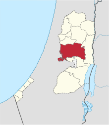
The Ramallah and al-Bireh Governorate (Arabic: محافظة رام الله والبيرة Muḥāfaẓat Rām Allāh wa l Bīra) is one of 16 Governorates of the West Bank and Gaza Strip. It covers a large part of the central West Bank, on the northern border of the Jerusalem Governorate. Its district capital or muhfaza (seat) is the city of al-Bireh.[1][2]
According to the Palestinian Central Bureau of Statistics (PCBS), the district had a population of 279,730 in 2007.[3] Its governor is Dr. Laila Ghannam, the first Female Governor.[4]
Localities

According to PCBS, the governorate has 78 localities including refugee camps in its jurisdiction. Thirteen localities retain the status of a municipality.
Cities
Municipalities
The following localities in the Ramallah and al-Bireh Governorate have populations over 5,000
- Bani Zeid
- Bani Zeid al-Sharqiya
- Beit Liqya
- Bir Zeit
- Deir Dibwan
- Deir Jarir
- al-Ittihad
- Kharbatha al-Misbah
- al-Mazra'a ash-Sharqiya
- Ni'lin
- Silwad
- Sinjil
- Turmus Ayya
- al-Zaitounah
Village councils
The following localities in the Ramallah and al-Bireh Governorate have populations over 1,000.
Refugee camps
See also
References
- ^ :: Al-Bireh Municipality ::
- ^ Administrative divisions in Palestine
- ^ [1]. (PDF) . Retrieved on 2010-12-03.
- ^ [2]


