
Banat
- For other uses, see Banat (disambiguation) and Ban (title)


The Banat is a geographical and historical region of Central Europe currently divided between three countries: the eastern part lies in Romania (the counties of Timiş, Caraş-Severin, Arad, and Mehedinţi), the western part in Serbia (the Serbian Banat, mostly included in the Vojvodina region, except for a small part included in Central Serbia), and a small northern part in Hungary (Csongrád county). It's populated by Banatians.
The Banat is a part of the Pannonian plain bordered by the River Danube to the south, the River Tisza (Theiss, Tissa, Tisa) to the west, the River Mureş to the north, and the Southern Carpathian Mountains to the east. Its historical capital was Timişoara, now in Timiş county in Romania.
Names
The term "banate" or "banat" designated a frontier province governed by a ban. The -ate suffix is based on Medieval Latin -atus or derives from Romanian, cf. Voievod/Voievodat and Cneaz/Cnezat.[citation needed]
There were several banats in the medieval Kingdom of Hungary, such as the banats of Dalmatia, Slavonia, Bosnia, and Croatia; these disappeared during the course of the Ottoman wars in Europe. But when the word is used without any other qualification, it indicates the Banat of Temeswar, which strangely acquired this title after the 1718 Treaty of Passarowitz, though it was never governed by a ban.
The name of the Banat is similar in the languages of the region; Romanian: Banat, Serbian: Банат (Banat), Hungarian: Bánát or Bánság, German: Banat, Turkish: Banat, Slovak: Banát, Banat Bulgarian: Banát, and Standard Bulgarian: Банат (Banat).
History


Before the Roman Empire under Trajan conquered the region of the Banat in Ad 106, the land was inhabited by Dacians. Roman rule was eventually overextended, however, and Emperor Aurelian (270–275) withdrew Roman forces to south of the Danube, leaving behind a Romanized population.
During the early medieval migrations, Slavs settled today's Banat in the 6th century. The region was incorporated into the First Bulgarian Empire at the beginning of the 9th century. The Hungarian historical chronicle Gesta Hungarorum speaks of a duke called Glad, a ruler of territory of Banat who came from Vidin and was a vassal of Tsar Simeon I of Bulgaria. His descendant was Ahtum, the last ruler, who was opposed to the establishment of the Hungarian Kingdom. Ahtum was an Orthodox Christian.
The region was incorporated into the feudal Kingdom of Hungary in the early 11th century (around 1008 or 1028) by Stephen I forming the prime-Csanad county which was divided latter into the counties Arad, Keve, Temes, Krassó and Csanád.
The Banat was incorporated into the Ottoman Empire in 1552, and became an Ottoman eyalet (province) named the Eyalet of Temeşvar. Since the 16th century, the Banat was mainly populated by Serbs (Rascians) and Romanians (Vlachs); thus in some historical sources it was mentioned under name Rascia and in some other as Wallachia. In 1594 Serbs in Banat started a large uprising against Ottoman rule. The Romanians also participated in this uprising.

In the 17th century, parts of the Banat were incorporated into the Habsburg Monarchy of Austria. In 1716, Prince Eugene of Savoy took the last parts of the Banat from the Ottomans. It received the title of the Banat of Temeswar after the Treaty of Passarowitz (1718), and remained a separate province of Habsburg Monarchy under military administration until 1751, when Empress Maria Theresa of Austria introduced a civil administration. The Banat of Temeswar province was abolished in 1778. The southern part of the Banat region remained within the Military Frontier (Banat Krajina) until the Frontier was abolished in 1871.
During the Ottoman rule, parts of Banat had a low population density after years of warfare, and much of the area was left almost desolate in marsh, heath, and forest. Count Claudius Mercy (1666-1734), who was appointed governor of the Banat of Temeswar in 1720, took numerous measures for the regeneration of the Banat. The marshes near the Danube and Tisza rivers were cleared, roads and canals were built at great expense of labour, German artisans and other settlers were attracted to colonize the district, and agriculture and trade encouraged.

.png)


Maria Theresa also took a great interest in the Banat; she colonized the region with large numbers of German peasants, encouraged the exploitation of the mineral wealth of the country, and generally developed the measures introduced by Mercy. German settlers arrived from Swabia, Alsace and Bavaria, as well as people from Austria. Many settlements in the eastern Banat thus were mostly German-inhabited. The ethnic Germans in the Banat region became known as the Danube Swabians, or Donauschwaben. Some of them, coming from French-speaking or linguistically mixed communes in Lorraine, maintained for some generations the French language, and a specific ethnic identity, later labelled as Banat French, Français du Banat. [1] Hungarians were not allowed to settle down in Banat after the colonization for a long time.
In 1779, the Banat region was incorporated into Habsburg Kingdom of Hungary, and the three counties Torontál, Temes and Krassó were created. In 1848, the western Banat became part of the Serbian Vojvodina, a Serbian autonomous region within the Habsburg Monarchy. During the Revolutions of 1848–1849, the Banat was respectively held by Serbian and Hungarian troops.
After the Revolution of 1848–1849, the Banat (together with Syrmia and Bačka) was made into a separate Austrian crownland known as the Voivodship of Serbia and Tamiš Banat, but, in 1860 this province was abolished and incorporated again into Habsburg Kingdom of Hungary.
After 1871, the former Military Frontier located in southern parts of the Banat came under civil administration and was incorporated into the Banat counties. Krassó and Szörény were united into Krassó-Szörény in 1881.
In 1918, the Banat Republic was proclaimed in Timişoara in October, and the government of Hungary recognized its independence. However, it was short-lived. After just two weeks, Serbian troops entered into the Banat region, and that was the end of the Banat Republic.
In 1918 and 1919, most of the Banat became part of Romania (Krassó-Szörény completely, two-thirds of Temes, and a small part of Torontál). The southwestern part (most of Torontál, one-third of Temes) became part of the newly formed Kingdom of Serbs, Croats and Slovenes (which became Yugoslavia). A small area near Szeged became part of newly independent Hungary. These borders were confirmed by the 1919 Treaty of Versailles and the 1920 Treaty of Trianon.
The territory of the Banat is presently part of the Romanian counties Timiş, Caraş-Severin, Arad and Mehedinţi, the Serbian autonomous province of Vojvodina and Belgrade City District, and the Hungarian Csongrád County.
Geography
Romanian Banat

In 1938, the counties of Timiş-Torontal, Caraş, Severin, Arad, and Hunedoara were joined to form Ţinutul Timiş, which encompassed the Romanian Banat.
On 6 September 1950, the province was replaced by the Timişoara Region (formed by the present-day counties of Timiş and Caraş-Severin).
In 1956, the southern half of the existing Arad Region was incorporated to the Timişoara Region.
In December 1960, the Timişoara Region was named the Banat Region.
On 17 February 1968, a new territorial division was made and today's Timiş, Caraş-Severin and Arad counties were formed.
Since 1998, Romania has been split into eight development regions, which act as a form of territorial autonomy divisions. The Vest development region is composed of four counties: Arad, Timiş, Hunedoara, and Caraş-Severin; thus it has almost same borders as the Timiş Province of 1929. The Vest development region is also a part of the Danube-Kris-Mures-Tisa Euroregion.
The Romanian Banat is mountainous in the south and southeast, while in the north, west and south-west it is flat and in some places marshy. The climate, except in the marshy parts, is generally healthy. Wheat, barley, oats, rye, maize, flax, hemp and tobacco are grown in large quantities, and the products of the vineyards are of a good quality. Game is plentiful and the rivers swarm with fish. The mineral wealth is great, including copper, tin, lead, zinc, iron and especially coal. Amongst its numerous mineral springs, the most important are those of Mehadia, with sulphurous waters, which were already known in the Roman period as the Termae Herculis (Băile Herculane). The present "Banat Region" of Romania includes some areas that are mountainous and were not part of the historical Banat or of the Pannonian plain.
| Banat |
|
|---|---|
| Dobruja |
|
| Moldavia |
|
| Transylvania | |
| Wallachia | |
| |
Serbian Banat


The Serbian Banat (Western Banat) was part of Serbian Vojvodina (1848-1849) and part of the Voivodship of Serbia and Tamiš Banat (1849-1860). After 1860, the Serbian Banat was part of Torontál and Temes counties of Habsburg Kingdom of Hungary. The center of Torontál county was Veliki Bečkerek, the current Zrenjanin.
The region was county of the Kingdom of Serbs, Croats and Slovenes between 1918 and 1922 (in 1918-1919, county was part of the province of Banat, Bačka and Baranja) and from 1922 to 1929 it was divided between Belgrade oblast and Podunavlje oblast. In 1929, most of the region was incorporated into the Danube Banovina (Danubian Banat), a province of the Kingdom of Yugoslavia, while the city of Pančevo was incorporated into self-governed Belgrade district.
Between 1941 and 1944, the Serbian Banat was occupied by the World War II Axis powers. Formally it was part of Serbia, but it actually was a virtually separate autonomous region ruled by its German minority. Since 1945, the Serbian Banat (together with Bačka and Syrmia), has been part of the Serbian Autonomous Province of Vojvodina, first as part of the Second and Third Yugoslavias, then as part of Serbia and Montenegro, and, since 2006, as part of an independent Serbia.
In Serbia, the Banat is mostly plains. Wheat, barley, oats, rye, maize, hemp and sunflower are grown, and mineral wealth consists of oil and natural gas. A popular tourist destination in the Banat is Deliblatska Peščara.
The districts of Serbia in Banat are:
- North Banat okrug (excluding municipalities of Ada, Senta and Kanjiža, which are situated in the region of Bačka)
- Central Banat okrug
- South Banat okrug
Serbian Banat also includes the area known as Pančevački Rit, which belongs to the Belgrade municipality of Palilula.
See also: Geographical regions in Serbia
Hungarian Banat
The Hungarian Banat consists of a small northern part of the region, which is part of the Csongrád County of Hungary. In addition to the Hungarian population, there are some Serbs (e.g. in Deszk, Szőreg).
Demographics
The Whole Banat
1660–1666:
In 1660–1666, Serbs lived in western (flat) part of the Banat, while Romanians lived in the eastern (mountainous) part. [2]
1743–1753:
In 1743–1753, ethnic composition of Banat looked as follows: [3]
- Three eastern districts had a Romanian population: Lugoj, Caransebeş, and Orşova.
- Three western districts had a Serbian population: Veliki Bečkerek, Pančevo, and Velika Kikinda.
- Six central districts had a mixed Serb-Romanian population: Timişoara, Lipova, Vršac, Nova Palanka, Ciacova, and Cenad.
1774:
According to 1774 data, the population of the Banat of Temeswar numbered 375,740 people and was composed of: [4]
- 220,000 (58.55%) Romanians
- 100,000 (26.61%) Serbs and Greeks
- 53,000 (14.11%) Germans
- 2,400 (0.64%) Hungarians and Bulgarians
- 340 (0.09%) Jews
1900:
In 1900, the population of Banat numbered 1,431,329 people, including: [5]
- 578,789 (40.4%) Romanians
- 362,487 (25.3%) Germans
- 251,938 (17.6%) Serbs
- 170,124 (11.9%) Hungarians
1910:
According to the 1910 census, the population of the Banat region (counties of Torontál, Temes, and Krassó-Szörény) numbered 1,582,133 people, including: [6] [7] [8] (*)
- 592,049 (37.42%) Romanians
- 387,545 (24.50%) Germans
- 284,329 (17.97%) Serbs
- 242,152 (15.31%) Hungarians
- a smaller numbers of other ethnic groups such as the Slovaks, Croats, Rusyns, Bulgarians, etc.
(*) Note: according to the 1910 census, the population of Romanian Banat included 52.6% Romanians, 25.6% Germans, 12.2% Hungarians, and 4.9% Serbs, while population of Serbian Banat included 40.53% Serbs, 22.14% Germans, 19.18% Hungarians, 12.94% Romanians, and 2.86% Slovaks. In Serbia the German population mostly fled or was expelled from the region after World War II, as a consequence of war time events. In Romania they mostly migrated after 1989 from economic reasons.
Population table:
The historical population of the Banat region in different time periods:
| Year | Total |
|---|---|
| 1717 | 85,166 |
| 1743 | 125,000 |
| 1753 | 210,992 |
| 1774 | 375,740 |
| 1797 | 667,912 |
| 1900 | 1,431,329 |
| 1910 | 1,582,133 |
Romanian Banat
The historical population of the Romanian Banat (the Timiş [9], [10] and Caraş-Severin [11], [12] counties) was as following:
| Year | Total | Romanians | Hungarians | Germans | Serbs | Roma |
|---|---|---|---|---|---|---|
| 1880 | 744,367 | 426,368 (57.3%) | 37,586 (5.0%) | 202,698 (27.2%) | 46,983 (6.3%) | n/a |
| 1890 | 812,799 | 446,816 (55.0%) | 50,899 (6.3%) | 233,006 (29.9%) | 41,356 (5.1%) | n/a |
| 1900 | 871,598 | 468,508 (53.8%) | 78,656 (9.0%) | 243,582 (27.9%) | 41,960 (4.8%) | n/a |
| 1910 | 902,210 | 474,787 (52.6%) | 109,873 (12.2%) | 231,391 (25.6%) | 44,598 (4.9%) | n/a |
| 1920 | 822,639 | 450,817 (54.8%) | 79,955 (9.7%) | 208,774 (25.4%) | n/a | n/a |
| 1930 | 878,877 | 473,781 (53.9%) | 91,421 (10.4%) | 215,031 (24.5%) | 37,113 (4.2%) | 16,471 (1.9%) |
| 1941 | 898,262 | 505,448 (56.3%) | 80,575 (9.0%) | 213,840 (23.8%) | n/a | n/a |
| 1956 | 896,668 | 589,369 (65.7%) | 85,790 (9.6%) | 137,697 (15.4%) | 40,018 (4.5%) | 9,309 (1.0%) |
| 1966 | 966,322 | 674,062 (69.8%) | 85,358 (8.8%) | 133,197 (13.8%) | 38,535 (4.0%) | 6,769 (0.7%) |
| 1977 | 1,082,461 | 796,007 (73.5%) | 86,763 (8.0%) | 119,972 (11.1%) | 29,514 (2.7%) | 15,755 (1.5%) |
| 1992 | 1,076,380 | 886,958 (82.4%) | 70,742 (6.6%) | 38,658 (3.6%) | 25,029 (2.3%) | 22,612 (2.1%) |
| 2002 | 1,011,145 | 859,690 (85.0%) | 56,380 (5.6%) | 20,323 (2.0%) | 19,355 (1.9%) | 23,998 (2.4%) |
Serbian Banat
According to 2002 census, the population of Serbian Banat (excluding its part near Belgrade) numbered 616,202 people and was composed of: [13]
- Serbs = 435,577 (70.69%)
- Hungarians = 62,890 (10.21%)
- others (including Romanians, Slovaks, etc).
Symbols
The traditional heraldic symbol of the Banat is a lion, which is nowadays present in both the Coat of Arms of Romania and the Coat of Arms of Vojvodina.
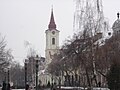
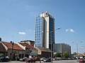
Cities
The largest cities in the Banat are:
Gallery
-
Timişoara, Romania, the Orthodox Cathedral
-
Timişoara, Romania, a fountain in the city centre
-
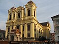 Timişoara, Romania, the Catholic Cathedral
 -
Zrenjanin, Serbia, City Hall and monument of king Petar I of Serbia
-
 Vršac, Serbia
 -
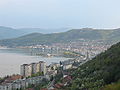 Orşova, Romania
 -
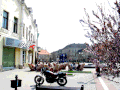
 Oţelu Roşu, Romania, Town center
 -
 Kikinda, Serbia
 -
 Skorenovac, Serbia
 -
 Lugoj, Romania
 -
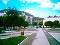
Jimbolia, Romania
-
 Pančevo, Serbia


References
- Miodrag Milin, Vekovima zajedno (Iz istorije srpsko-rumunskih odnosa), Temišvar, 1995.
- Milan Tutorov, Mala Raška a u Banatu, istorika Zrenjanina i Banata, Zrenjanin, 1991.
- Milan Tutorov, Banatska rapsodija, istorika Zrenjanina i Banata, Novi sad, 2001.
- Dr. Branislav Bukurov, Bačka, Banat i Srem, Novi Sad, 1978.
- Milojko Brusin, Naša razgraničenja sa susedima 1919-1920, Novi Sad, 1998.
- Jovan M. Pejin, Iz prošlosti Kikinde, Kikinda, 2000.
- Dušan Belča, Mala istorija Vršca, Vršac, 1997.
Notes
- ^ Smaranda Vultur, De l’Ouest à l’Est et de l’Est à l’Ouest : les avatars identitaires des Français du Banat, Texte presenté a la conférence d'histoire orale "Visibles mais pas nombreuses : les circulations migratoires roumaines", Paris, 2001
- ^ Dr. Dušan J. Popović, Srbi u Vojvodini, knjiga 2, Novi Sad, 1990.
- ^ Dr. Dušan J. Popović (see above)
- ^ Miodrag Milin, Vekovima zajedno (iz istorije srpsko-rumunskih odnosa), Temišvar, 1995.
- ^ http://www.banatul.com/
- ^ http://www.talmamedia.com/php/district/district.php?county=Toront%E1l
- ^ http://www.talmamedia.com/php/district/district.php?county=Temes
- ^ http://www.talmamedia.com/php/district/district.php?county=Krass%F3-Sz%F6r%E9ny
- ^ Ethnic composition of the Timiş County (1850-1992)
- ^ Recensământ 2002, Census 2002: Timiş County
- ^ Ethnic composition of the Caraş-Severin County (1850-1992)
- ^ Recensământ 2002, Census 2002: Caraş-Severin County
- ^ Popis stanovništva, domaćinstava i stanova 2002. Knjiga 1: Nacionalna ili etnička pripadnost po naseljima. Republika Srbija, Republički zavod za statistiku Beograd 2003. ISBN 86-84443-00-09
External links
- banatul.com Template:En icon/Template:Ro icon
- backabanat.com Template:Sr icon
- Development of Ethnic Structure in the Banat 1890 - 1992
- Smaranda Vultur, De l’Ouest à l’Est et de l’Est à l’Ouest : les avatars identitaires des Français du Banat Template:Fr icon
- Návštěva Svaté Heleny, reportáž z expedice Roadtrip 2007 - návštěva Banátu (Svaté Heleny) Template:Cs icon