
Meriden, Connecticut
Meriden, Connecticut | |
|---|---|
 Seal | |
| Nickname: The Silver City of the World | |
 Location in Connecticut | |
| NECTA | New Haven |
| Region | South Central Region |
| Incorporated (town) | 1806 |
| Incorporated (city) | 1867 |
| Consolidated | 1922 |
| Government | |
| • Type | Council-manager |
| • Council leaders | Mark Benigni, Mayor Matthew C. Dominello, Deputy Mayor Stephen T. Zerio, Council Leader Keith Gordon, Deputy Leader Patricia D. Lynes, Deputy Leader |
| • City manager | Lawrence J. Kendzior |
| Area | |
| • Total | 62.5 km2 (24.1 sq mi) |
| • Land | 61.5 km2 (23.8 sq mi) |
| • Water | 1.0 km2 (0.4 sq mi) |
| Elevation | 54 m (177 ft) |
| Population (2005)[1] | |
| • Total | 59,653 |
| • Density | 968/km2 (2,510/sq mi) |
| Time zone | UTC-5 (Eastern) |
| • Summer (DST) | UTC-4 (Eastern) |
| ZIP code | 06450, 06451 |
| Area code | 203 |
| FIPS code | 09-46450 |
| GNIS feature ID | 0208834 |
| Website | http://www.cityofmeriden.org/ |
Meriden is a city in New Haven County, Connecticut, United States. According to 2005 Census Bureau estimates, the population of the city is 59,653.[1]
History
Meriden was originally part of Wallingford. It was granted a separate meetinghouse in 1727, became a town in 1806, and incorporated as a city in 1867. It was named for the town of Meriden, West Midlands, England.
The oldest house in town still standing, built by Solomon Goffe in 1711, is now a museum, the Solomon Goffe House.
In the 1800s, Meriden earned the nickname “Silver City,” due to the large number of cutlery and related products which were manufactured here by companies such as International Silver and Meriden Cutlery.

Charles Parker and his younger brother, opened their first manufacturing factory in Meriden in 1832, with a capital outlay of $70.00. Over the years they manufactured a wide variety of products‚ from steam engines, train wheels and printing presses to piano stools. During the American Civil War Parker's Meriden Machine Company was under Union contract to produce 10,000 repeating rifles and 15,000 Springfield rifles. Parker began producing his own shotgun, referred to as “The Gun of 1866”. In 1868, Charles and his sons, Wilbur, Charles and Dexter started the Parker Brothers Gun Company, which continued as an independent company until 1934 when it was purchased by the Remington Arms Company. [1]
The Hanging Hills' Hubbard Park was financed by Walter Hubbard, local entrepreneur and president of the Bradley & Hubbard Manufacturing Company. Hubbard elicited the assistance of notable landscape architect Fredrick Law Olmstead in drawing up the design. [2]
Edwin Howard Armstrong, a network radio pioneer who invented FM radio, used West Peak for the location of one of the first FM radio broadcasts in 1939. His original 70 feet (21 m) tall radio mast still stands on the peak. Currently West Peak is home to six FM broadcast stations, including WPKT, WWYZ, WKSS, WDRC-FM, WPHH and WHCN.[3] In 1900, Castle Craig was dedicated in Hubbard Park.
The Curtis Memorial Library opened in 1903.
Meriden is known as the home of the first steamed cheeseburger, which remains a popular local favorite to this day.
The Franciscan Sisters of the Eucharist have their mother house in Meriden as do the Franciscan Brothers of the Eucharist.
Geography

According to the United States Census Bureau, the city has a total area of 24.1 square miles (62.5 km²), of which, 23.8 square miles (61.5 km²) of it is land and 0.4 square miles (1.0 km²) of it (1.66%) is water.
Meriden is a showcase for a number of prominent peaks of the Metacomet Ridge, a mountainous traprock ridgeline that stretches from Long Island Sound to nearly the Vermont border. Notable peaks in Meriden include the Hanging Hills (West Peak, East Peak, South Mountain, and Cathole Mountain); Lamentation Mountain, Chauncey Peak, and Besek Mountain. [Castle Craig]], a city landmark for over a century, was constructed among the Hanging Hills in Hubbard Park.
The Quinnipiac River cuts through the southwest quadrant of the city, which is known to area residents as "South Meriden". Here, the river cuts through two hills for almost a mile, resulting in a gorge full of exposed sandstone and brownstone cliffs.
Principal communities
- Meriden center
- South Meriden
Demographics

As of the census² of 2000, there were 58,244 people, 22,951 households, and 14,964 families residing in the city. The population density was 2,452.8 people per square mile (946.9/km²). There were 24,631 housing units at an average density of 1,037.3/sq mi (400.4/km²). The racial makeup of the city was 80.2% White, 6.4% Black or African American, 0.4% Native American, 1.4% Asian, 0.02% Pacific Islander, 8.6% from other races, and 2.9% from two or more races. Hispanic or Latino of any race were 32.4% of the population.
There were 22,951 households out of which 31.3% had children under the age of 18 living with them, 45.4% were married couples living together, 15.2% had a female householder with no husband present, and 34.8% were non-families. 28.9% of all households were made up of individuals and 10.7% had someone living alone who was 65 years of age or older. The average household size was 2.49 and the average family size was 3.08.
In the city the population was spread out with 25.7% under the age of 18, 8.1% from 18 to 24, 30.2% from 25 to 44, 21.9% from 45 to 64, and 14.1% who were 65 years of age or older. The median age was 36 years. For every 100 females there were 94.0 males. For every 100 females age 18 and over, there were 89.2 males.
The median income for a household in the city was $43,237, and the median income for a family was $52,788. Males had a median income of $39,633 versus $10,268 for females. The per capita income for the city was $20,597. About 17.5% of families and 20.5% of the population were below the poverty line, including 33.3% of those under age 18 and 23.8% of those age 65 or over.
| Voter Registration and Party Enrollment as of October 25, 2005[4] | |||||||||||||||||||||||||
|---|---|---|---|---|---|---|---|---|---|---|---|---|---|---|---|---|---|---|---|---|---|---|---|---|---|
| Party | Active Voters | Inactive Voters | Total Voters | Percentage | Democratic | 9,225 | 524 | 9,749 | 30.15% | Republican | 4,275 | 213 | 4,488 | 13.88% | Unaffiliated | 16,927 | 1,147 | 18,074 | 55.90% | Minor Parties | 19 | 2 | 21 | 0.06% | |
| Total | 30,446 | 1,886 | 32,332 | 100% | |||||||||||||||||||||
Transportation

| Historical population of Meriden[2] | |
| 1810 | 1,249 |
| 1820 | 1,309 |
| 1830 | 1,708 |
| 1840 | 1,880 |
| 1850 | 3,559 |
| 1860 | 7,426 |
| 1870 | 10,495 |
| 1880 | 18,340 |
| 1890 | 25,423 |
| 1900 | 28,659 |
| 1910 | 32,066 |
| 1920 | 34,764 |
| 1930 | 38,481 |
| 1940 | 39,494 |
| 1950 | 44,088 |
| 1960 | 51,850 |
| 1970 | 55,959 |
| 1980 | 57,118, |
| 1990 | 59,479 |
| 2000 | 58,244 |
| 2002 | 58,675 (est.)[3] |
Railroad
The city of Meriden is connected to the cities of New Haven, Hartford, and Springfield, Massachusetts by regional rail service provided by Amtrak, which runs north-to-south through the center of the city. This rail line opened in 1839, and operated for many years under the New York, New Haven and Hartford Railroad. The city was also serviced by the Middletown, Meriden and Waterbury Railroad, which provided both freight and passenger service to Waterbury and Middletown from 1888 until its abandonment in 1924.
In the Quinnipiac River Gorge in South Meriden, 1.5 miles of the original MM&W Railroad right of way has been converted into a recreational linear trail. Open to the public in December 2006, with formal dedication planned for November 3, 2007.
Highway
The city of Meriden is located on Interstate 91, which provides access to Hartford, Springfield, Massachusetts, and New Haven. Interstate 691 provides access to Interstate 84 and points west such as Waterbury. The Wilbur Cross Parkway, which provides access to points south such as Wallingford, New Haven, and New York City becomes the Berlin Turnpike on the northern end of Meriden.
Schools
- Public Elementary (K-5):
- John Barry
- Benjamin Franklin
- Nathan Hale
- Hanover
- Thomas Hooker
- Casimir Pulaski
- Israel Putnam
- Roger Sherman
- Public Middle (6-8)
- Lincoln
- Washington
- Public High (9-12)
- Magnet Middle
- Thomas A. Edison, run by ACES of North Haven
- State Technical High
- Horace C. Wilcox
- Private Schools
- St. Mary School (K-8) (closed after the 2006-2007 school year due to lack of enrollment)
- St. Stanislaus School (K-8)
- St. Joseph School (K-8)
- Our Lady of Mount Carmel (K-8)
Pictures
-
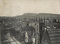 View from Town Hall tower, 1907
 -
 High School building, 1909


Points of interest

- Castle Craig
- Curtis Memorial Library
- Hanging Hills
- Hubbard Park
- Moses Andrew Homestead
- Old Traffic Tower
- Solomon Goffe House
- Red Bridge
- Meriden Square Mall
- Hunter Golf Course
Meriden in popular culture
Meriden was the location chosen for the filming of the 1989 Robert De Niro film Jacknife. Many Meriden landmarks can be seen in the film, and many Meriden residents boast of encountering De Niro during the filming.
Dan Petriw's investigative special for Channel 8 News about the "tail pipe golf ball" craze of the 1990's was filmed at Fantozzi's Oldsmobile Dealership on Broad Street. Several commuters and car dealers in Meriden had reported that tail pipes on their new and used vehicles were randomly being stuffed with golf balls, thereby causing major damage to their exhaust systems. Petriw assisted the Meriden Police Department in the capture of the suspects by placing hidden cameras in the Meriden City commuter parking lot as well in several locations at Fantozzi's Oldsmobile dealership. The juveniles were tried and sentenced by the Hon. Judge Jared Steinberg at the Meriden Superior Court.
Meriden's Ted's Steamed Cheeseburger Restaurant was featured in the documentary Hamburger America.
Tomie dePaola's "26 Fairmount Avenue" is based on the author's Meriden childhood.
Many towns in the western United States were named for Meriden, Connecticut including Meriden, Iowa, Meriden, Kansas, Meriden, Wyoming, and Meriden Township, Minnesota.
Notable natives
- John Joseph "Jack" Barry (1887 - 1961) Baseball player and manager in Major League Baseball, later a renowned college baseball coach; born in Meriden.
- Gary Burr, a 2005 inductee into the Nashville Songwriters Hall of Fame.
- Tomie dePaola (b. 1934) Author and illustrator of children's picture books, including the Strega Nona and Meet the Barkers series.
- Toby Driver (1978- ), composer and musician (with Kayo Dot).
- Rob Hyman (b. 1950) Lead singer and keyboard player for the rock band The Hooters.
- Frank Kowalski (1907-1974) was a United States Representative from Connecticut.
- William Lyman (fl. 1870s) Inventor credited with inventing the modern can opener.
- Mary McGarry Morris (b. 1943) - novelist
- George P. Murdock (1897–1985) Cultural anthropologist, he initiated the cross-cultural survey, as an instrument of sociological and anthropological generalization.
- Rosa Ponselle (1897-1981) Soprano, later artistic director of the Baltimore Civic Opera.
- Warren Sattler (b. 1934), Cartoonist and illustrator with a long career in comic strips, comic books, and other media.
- Gary Waslewski Major league pitcher from 1960-1972, Pittsburgh Pirates (1960-64) Boston Red Sox (1964-69), also St. Louis Cardinals, Montreal Expos, New York Yankees, Oakland Athletics.
- Frank Wuterich (1980-) U.S. Marine accused of war crimes in Haditha, Iraq.
References
- ^ a b "Annual Estimates of the Population for All Incorporated Places in Connecticut" (CSV). 2005 Population Estimates. U.S. Census Bureau, Population Division. June 21 2006. Retrieved November 17.
{{cite web}}: Check date values in:|accessdate=and|year=(help); Unknown parameter|accessyear=ignored (|access-date=suggested) (help) - ^ City of Meriden. Cited Dec. 13, 2007
- ^ This Week in Amateur Radio. Cited Dec. 13, 2007
- ^ "Registration and Party Enrollment Statistics as of October 25, 2005" (PDF). Connecticut Secretary of State. Retrieved 2006-10-02.
External links

- City of Meriden
- MeridenBiz - Economic Development Information
- Franciscan Sisters of the Eucharist
- Meriden Land Trust
- Central Regional Tourism District
Municipalities and communities of New Haven County, Connecticut, United States | ||
|---|---|---|
| Cities |  | |
| Towns | ||
| Boroughs | ||
| CDPs | ||
| Other communities | ||