
Kalbajar: Difference between revisions
the unrecognised republic is already mentioned once in the introduction |
|||
| Line 32: | Line 32: | ||
|website = |
|website = |
||
}} |
}} |
||
'''Kalbajar''' ({{lang-az|Kəlbəcər}}, also spelled as ''Kelbajar'', ''Kälbäjär'', ''Kelbadzhar'', ''Kelbadshar'', ''Kelbadjar'', ''Kelbadžar''; '''Karvachar''' ({{lang-hy|Քարվաճառ}} ''Karvachar'') |
'''Kalbajar''' ({{lang-az|Kəlbəcər}}, also spelled as ''Kelbajar'', ''Kälbäjär'', ''Kelbadzhar'', ''Kelbadshar'', ''Kelbadjar'', ''Kelbadžar''; '''Karvachar''' ({{lang-hy|Քարվաճառ}} ''Karvachar'') is the administrative center of [[Kalbajar District]] of [[Azerbaijan]]; but the city along with the associated rayon is under the control of the unrecognized [[Nagorno-Karabakh Republic]] after it was captured by Armenian forces during the [[Battle of Kalbajar]], near the end of the [[Nagorno-Karabakh War]].<ref name="unhcr">{{cite web |url=http://www.unhcr.org/refworld/docid/3b00f15764.html |title=Resolution 822 (1993) adopted by the United Nations' Security Council at its 3205th meeting |last1= |first1= |last2= |first2= |date=April 30, 1993 |work= |publisher=UNHCR Refworld |accessdate=22 February 2011 |quote=''Noting with alarm the escalation in armed hostilities and, in particular, the latest invasion of the Kelbadjar District of the Republic of Azerbaijan by local Armenian forces''}}</ref> |
||
==Nagorno-Karabakh War== |
==Nagorno-Karabakh War== |
||
Revision as of 18:55, 18 January 2015
Kəlbəcər (Kalbajar)
Քարվաճառ (Karvachar) | |
|---|---|
 | |
 Coat of arms | |
| Country | De facto De jure |
| NKR region Azerbaijani district | Shahumyan Region Kalbajar District |
| Elevation | 1,584 m (5,197 ft) |
| Population (2010) | |
| • Total | 500 |
| Time zone | UTC+4 (AZT) |
Kalbajar (Azerbaijani: Kəlbəcər, also spelled as Kelbajar, Kälbäjär, Kelbadzhar, Kelbadshar, Kelbadjar, Kelbadžar; Karvachar (Armenian: Քարվաճառ Karvachar) is the administrative center of Kalbajar District of Azerbaijan; but the city along with the associated rayon is under the control of the unrecognized Nagorno-Karabakh Republic after it was captured by Armenian forces during the Battle of Kalbajar, near the end of the Nagorno-Karabakh War.[1]
Nagorno-Karabakh War
Armenian and Karabakh forces conquered Kalbajar the Nagorno-Karabakh War, due to its strategic location between the former Nagorno-Karabakh Autonomous Oblast and Armenia.[2] Human Rights Watch findings concluded that during the Kelbajar offensive both sides violated rules of wars, including indiscriminate fire, and the taking of hostages."[3] This capture was condemned by the UN Security Council.[1]
Lakes, rivers, mountains and zones
There are 13 lakes in local plains and mountains.
Kalbajar’s longest river is the Tartarchay. Its tributaries are the Tutkhun, Lev, Zaylik, Alolar, Garaarkhaj (Sarkar) rivers.
There are also 20 well-known water springs.
70-80 per cent of the district is made up of mountains and each of them has a name. Since motor traffic in mountains is limited, local people have divided the district in different zones:
- 1. Upper zone – territories stretching from the center westwards
- 2. Ayrim zone – north-west
- 3. Gamishli-Lev zone – north-east
- 4. Tutgu zone – area around Zulfugarli- Baslibel
- 5. Sarsang SES zone – forests in the east
- 6. The Dalidagh-Sariyer-Keyti zone consists of bare mountains and plains
Gallery
-
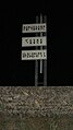 Sign at northern site of the city with Armenian text: "Karvachar is an Armenian fortress"
 -
 Children playing soccer in the city
 -
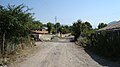 Other city street
 -
 Dadivank Armenian monastery (9th–13th centuries), located 22 km west of Karvachar


.jpg)
References
- ^ a b "Resolution 822 (1993) adopted by the United Nations' Security Council at its 3205th meeting". UNHCR Refworld. April 30, 1993. Retrieved 22 February 2011.
Noting with alarm the escalation in armed hostilities and, in particular, the latest invasion of the Kelbadjar District of the Republic of Azerbaijan by local Armenian forces
- ^ The Nagorno-Karabakh Conflict: A Legal Analysis. Heiko Krüger. Springer, 2010. ISBN 3642117872, 9783642117879. p. 102
- ^ Azerbaijan: Seven years of conflict in Nagorno-Karabakh By Human Rights Watch/Helsinki (Organization : U.S.) p.13
External links
- Kalbajar at GEOnet Names Server
- World Gazetteer: Azerbaijan – World-Gazetteer.com
- Template:ADG
| Capital city | ||
|---|---|---|
| Provinces | ||
| Provincial capitals | ||
| Other urban communities |
| |
