
Murovdağ: Difference between revisions
I don't care. we are not going to use erdogan regime sources, period. |
|||
| Line 19: | Line 19: | ||
The Murovdağ ridge extends north from [[Hinaldag|Hinaldag Peak]] through Gamish (or Gomshasar) Mountain. The northeastern slope features a group of scenic lakes, including [[Lake Göygöl|Göygöl]] near the northern slope. The [[Karabakh Plateau]] extends from the south of Murovdağ. [[Fir]] and [[spruce]] forests are spread as far southeast as the Murovdağ. The summer mountain pastures of Murovdağ were traditionally used by [[Azerbaijan]]i and Armenian shepherds. |
The Murovdağ ridge extends north from [[Hinaldag|Hinaldag Peak]] through Gamish (or Gomshasar) Mountain. The northeastern slope features a group of scenic lakes, including [[Lake Göygöl|Göygöl]] near the northern slope. The [[Karabakh Plateau]] extends from the south of Murovdağ. [[Fir]] and [[spruce]] forests are spread as far southeast as the Murovdağ. The summer mountain pastures of Murovdağ were traditionally used by [[Azerbaijan]]i and Armenian shepherds. |
||
==History== |
|||
The mountain [[ridge]] forms the northern part of the [[Nagorno-Karabakh line of contact|line of contact]] separating the unrecognized [[Nagorno-Karabakh Republic]] from Azerbaijan. Its southern slopes run through the [[Martakert]] region of Nagorno-Karabakh.<ref name="civil wars">Karl DeRouen, ''Civil wars of the world''. p 105. [[ABC-CLIO]] - 2007. {{ISBN|1-85109-919-0}}</ref> |
The mountain [[ridge]] forms the northern part of the [[Nagorno-Karabakh line of contact|line of contact]] separating the unrecognized [[Nagorno-Karabakh Republic]] from Azerbaijan. Its southern slopes run through the [[Martakert]] region of Nagorno-Karabakh.<ref name="civil wars">Karl DeRouen, ''Civil wars of the world''. p 105. [[ABC-CLIO]] - 2007. {{ISBN|1-85109-919-0}}</ref> |
||
In 1993 the ridge was the scene of a battle between Armenian and Azeri forces that ended in an Armenian victory.<ref> {{Cite web | title = Azeri Veterans Recall Military Fiasco | url=https://iwpr.net/global-voices/azeri-veterans-recall-military-fiasco }}</ref> |
In 1993 the ridge was the scene of a battle between Armenian and Azeri forces that ended in an Armenian victory.<ref> {{Cite web | title = Azeri Veterans Recall Military Fiasco | url=https://iwpr.net/global-voices/azeri-veterans-recall-military-fiasco }}</ref> |
||
==2020 Nagorno-Karabakh conflict== |
|||
During the 2020 conflict, reportedly by Azerbaijan, the peak of Murovdag came into Azerbaijani control.<ref>{{Cite news |url=https://www.trtworld.com/asia/azerbaijan-kills-over-a-dozen-armenian-servicemen-in-karabakh-fighting-40084 |title=Azerbaijan kills over a dozen Armenian servicemen in Karabakh fighting |date=27 September 2020 |access-date=27 September 2020 |website=trtworld.com |publisher=[[TRT World]] |language=en }}</ref><ref>{{Cite web|url=https://www.turan.az/ext/news/2020/9/free/politics%20news/en/128022.htm|title=Enemy Driven out of Commanding Heights near Talysh}}</ref> |
|||
==Gallery== |
==Gallery== |
||
Revision as of 17:13, 3 October 2020
| Murovdağ | |
|---|---|
 | |
| Highest point | |
| Elevation | 3,724 m (12,218 ft) |
| Dimensions | |
| Length | 70 km (43 mi) |
| Naming | |
| Native name | Murovdağ/Mrav Error {{native name checker}}: parameter value is malformed (help) |
| Geography | |
 Murovdağ Location of the mountain | |
| Country | |
| Range coordinates | 40°16′00″N 46°19′00″E / 40.2667°N 46.3167°E |
The Murovdağ (also spelled as Murovdagh, Azerbaijani: Murovdağ) or Mrav[1][2] (Armenian: Մռավի լեռնաշղթա, romanized: Mravi Lernash'ghta) is the highest mountain range in the Lesser Caucasus. The range is about 70 kilometres (43 mi) long, and Gamish Mountain is its highest peak at 3,724 metres (12,218 ft). It is made up mainly of Jurassic, Cretaceous and Paleogene rocks.[3]
The Murovdağ ridge extends north from Hinaldag Peak through Gamish (or Gomshasar) Mountain. The northeastern slope features a group of scenic lakes, including Göygöl near the northern slope. The Karabakh Plateau extends from the south of Murovdağ. Fir and spruce forests are spread as far southeast as the Murovdağ. The summer mountain pastures of Murovdağ were traditionally used by Azerbaijani and Armenian shepherds.
History
The mountain ridge forms the northern part of the line of contact separating the unrecognized Nagorno-Karabakh Republic from Azerbaijan. Its southern slopes run through the Martakert region of Nagorno-Karabakh.[1] In 1993 the ridge was the scene of a battle between Armenian and Azeri forces that ended in an Armenian victory.[4]
2020 Nagorno-Karabakh conflict
During the 2020 conflict, reportedly by Azerbaijan, the peak of Murovdag came into Azerbaijani control.[5][6]
Gallery
-
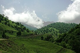
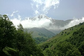
 View from Nagorno-Karabakh, village of Qozlu (local name Vaghuhas)
 -
-
-


Notes
- ^ a b Karl DeRouen, Civil wars of the world. p 105. ABC-CLIO - 2007. ISBN 1-85109-919-0
- ^ "NAGORNO-KARABAKH REPUBLIC " Geographical location". Ministry of Foreign Affairs of the Nagorno Karabakh Republic. Retrieved 7 February 2012.
- ^ Azerbaijan Soviet Encyclopedia (1983), vol. 7, p. 93
- ^ "Azeri Veterans Recall Military Fiasco".
- ^ "Azerbaijan kills over a dozen Armenian servicemen in Karabakh fighting". trtworld.com. TRT World. 27 September 2020. Retrieved 27 September 2020.
- ^ "Enemy Driven out of Commanding Heights near Talysh".