
Portal:Alaska
Introduction

Alaska (/əˈlæskə/ ⓘ ə-LASS-kə) is a non-contiguous U.S. state on the northwest extremity of North America. It borders the Canadian province of British Columbia and the Yukon territory to the east; it shares a western maritime border in the Bering Strait with Russia's Chukotka Autonomous Okrug. The Chukchi and Beaufort Seas of the Arctic Ocean lie to the north and the Pacific Ocean lies to the south. Technically a semi-exclave of the U.S., it is the largest exclave in the world.
Alaska is the largest U.S. state by area, comprising more total area than the next three largest states of Texas, California and Montana combined, and is the seventh-largest subnational division in the world. It is the third-least populous and most sparsely populated U.S. state, but is, with a population of 736,081 as of 2020, the continent's most populous territory located mostly north of the 60th parallel, with more than quadruple the combined populations of Northern Canada and Greenland. The state contains the second-largest and largest cities in the United States by area: the state capital of Juneau, and its former capital, Sitka, respectively. The state's most populous city is Anchorage and approximately half of Alaska's residents live within its metropolitan area. (Full article...)
Selected general articles
-


Map of Southcentral Alaska
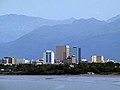
Southcentral Alaska (Russian: Юго-Центральная Аляска), also known as the Gulf Coast Region, is the portion of the U.S. state of Alaska consisting of the shorelines and uplands of the central Gulf of Alaska. More than half of the state's entire population lives in this region, concentrated in and around the city of Anchorage. The region is Alaska’s best-connected region, with the Port of Anchorage, Ted Stevens, Anchorage International Airport, and the Alaska Railroad servicing the area.
The area includes Cook Inlet, the Matanuska-Susitna Valley, the Kenai Peninsula, Prince William Sound, and the Copper River Valley. Tourism, fisheries, and petroleum production are important economic activities. (Full article...) -

Alaska in 1895 (Rand McNally). The boundary of southeastern Alaska shown is that claimed by the United States before the conclusion of the Alaska boundary dispute.
The history of Alaska dates back to the Upper Paleolithic period (around 14,000 BC), when foraging groups crossed the Bering land bridge into what is now western Alaska. At the time of European contact by the Russian explorers, the area was populated by Alaska Native groups. The name "Alaska" derives from the Aleut word Alaxsxaq (also spelled Alyeska), meaning "mainland" (literally, "the object toward which the action of the sea is directed").
The U.S. purchased Alaska from Russia in 1867. In the 1890s, gold rushes in Alaska and the nearby Yukon Territory brought thousands of miners and settlers to Alaska. Alaska was granted territorial status in 1912 by the United States of America. (Full article...) -

Ketchikan Gateway Borough is a borough located in the U.S. state of Alaska. As of the 2020 census its population was 13,948, up from 13,477 in 2010. The borough seat is Ketchikan. The borough is the second most populous borough in Southeast Alaska, the first being Juneau Borough.
Ketchikan Gateway Borough comprises the Ketchikan, AK Micropolitan Statistical Area. (Full article...) -

Yukon–Koyukuk Census Area (/ˈjuːkɒn ˈkaɪjəkək/) is a census area in the U.S. state of Alaska. As of the 2020 census, the population was 5,343, down from 5,588 in 2010. With an area of 147,842.51 sq mi (382,910.3 km2), it is the largest of any county or county-equivalent in the United States, or slightly larger than the entire state of Montana. It is part of the unorganized borough of Alaska and therefore has no borough seat. Its largest communities are the cities of Galena, in the west, and Fort Yukon, in the northeast. (Full article...) -
Ahtna, Incorporated is one of thirteen Alaska Native Regional Corporations created under the Alaska Native Claims Settlement Act of 1971 (ANCSA) in settlement of aboriginal land claims. Ahtna, Incorporated was incorporated in Alaska on June 23, 1972. Headquartered in Glennallen, Alaska, Ahtna is a for-profit corporation with more than 2,000 Alaska Native shareholders primarily of Ahtna Athabascan descent.
Ahtna, Inc. stewards over 1,500,000 acres (6,100 km2) of lands granted through land claims under ANCSA finalized between 1971 and 1998. The Ahtna region is located primarily in the Copper River Census Area of Alaska, with a small spillover into the neighboring Denali Borough in the area of Cantwell. Ahtna's total entitlement under ANCSA is 1,770,000 acres (7,160 km2). (Full article...) -
The Aleutian Islands (/əˈluːʃən/ ⓘ ə-LOO-shən; Russian: Алеутские острова; Aleut: Unangam Tanangin, "land of the Aleuts"; possibly from the Chukchi aliat, or "island")—also called the Aleut Islands, Aleutic Islands, or, before 1867, the Catherine Archipelago—are a chain of 14 main, larger volcanic islands and 55 smaller ones. Most of the Aleutian Islands belong to the U.S. state of Alaska, with the archipelago encompassing the Aleutians West Census Area and the Aleutians East Borough. The Commander Islands, located further to the west, belong to the Russian federal subject of Kamchatka Krai, of the Russian Far East. The islands form part of the Aleutian Arc of the Northern Pacific Ocean, and occupy a land area of 6,821 sq mi (17,666 km2) that extends westward roughly 1,200 mi (1,900 km) from the Alaskan Peninsula mainland, in the direction of the Kamchatka Peninsula; the archipelago acts as a border between the Bering Sea to the north and the Pacific Ocean to the south. Crossing longitude 180°, at which point east and west longitude end, the archipelago contains both the westernmost and easternmost parts of the United States, by longitude (Amatignak Island and Semisopochnoi Island, respectively). The westernmost U.S. island, in real terms, however, is Attu Island, west of which runs the International Date Line. While nearly all of the archipelago is part of Alaska (and is usually considered as being in the "Alaskan Bush") at the extreme western end, the small, geologically-related Commander Islands belong to Russia.
The Aleutian Islands, with their 57 volcanoes, form the northernmost part of the Pacific Ring of Fire. Physiographically, they are a distinct section of the larger Pacific Border province, which, in turn, is part of the larger Pacific Mountain System physiographic division. The islands are considered to be among the most geographically-isolated areas of the Northern Pacific. (Full article...) -
The Denali Borough is a borough located in the U.S. state of Alaska. As of the 2020 census the population of the borough was 1,619, down from 1,826 in 2010. The borough seat and most populated community is Healy, and its only incorporated place is Anderson. The borough was incorporated in December 1990.
The area was previously a part of the Unorganized Borough, with the Upper Railbelt School District serving as the region's rural education attendance area (which was replaced by a school district under the borough's umbrella upon incorporation). (Full article...) -
Kodiak Island Borough (Russian: Остров Кадьяк) is a borough in the U.S. state of Alaska. At the 2020 census, the population was 13,101, down from 13,592 in 2010. The borough seat is Kodiak. (Full article...) -

Copper River Census Area is a census area located in the state of Alaska, United States. It is part of the Unorganized Borough and therefore has no borough seat. On January 2, 2019, it was split from the Valdez–Cordova Census Area, along with neighboring Chugach Census Area.
As of the 2020 census, the census area had a population of 2,617; its largest communities are the census-designated places of Glennallen and Copper Center. (Full article...) -

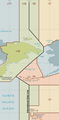
Map of Beringia showing the Seward Peninsula.
The Seward Peninsula is a large peninsula on the western coast of the U.S. state of Alaska whose westernmost point is Cape Prince of Wales. The peninsula projects about 200 mi (320 km) into the Bering Sea between Norton Sound, the Bering Strait, the Chukchi Sea, and Kotzebue Sound, just below the Arctic Circle. The entire peninsula is about 210 mi (330 km) long and 90–140 mi (145–225 km) wide. Like Seward, Alaska, it was named after William H. Seward, the United States Secretary of State who fought for the U.S. purchase of Alaska.
The Seward Peninsula is a remnant of the Bering land bridge, a roughly thousand-mile-wide swath of land connecting Siberia with mainland Alaska during the Pleistocene Ice Age. This land bridge aided in the migration of humans, as well as plant and animal species, from Asia to North America. Excavations at sites such as the Trail Creek Caves and Cape Espenberg in the Bering Land Bridge National Preserve as well as Cape Denbigh to the south have provided insight into the timeline of prehistorical migrations from Asia to the Seward Peninsula. (Full article...) -

Federal presidential vote in Alaska, 1960-2020
Although in its early years of statehood, Alaska was a Democratic state, since the early 1970s it has been characterized as Republican-leaning. Local political communities have often worked on issues related to land use development, fishing, tourism, and individual rights. Alaska Natives, while organized in and around their communities, have been active within the Native corporations. These have been given ownership over large tracts of land, which require stewardship. The state has an independence movement favoring a vote on secession from the United States, with the Alaskan Independence Party, but its membership has shrunk in recent decades (to 18,725 as of 2022).
Alaska regularly supports Republicans in presidential elections and has done so since statehood. Republicans have won the state's electoral college votes in every election except Democrat Lyndon B. Johnson's 1964 landslide. No state has voted for a Democratic presidential candidate fewer times. The 1960 and 1968 elections were close, however, since 1972, Republicans have consistently carried the state by large margins. However, in 2012 and 2020, Democrats obtained over 40% of the vote in the state for the first time since the 1960s. (Full article...) -
The City and Borough of Yakutat (/ˈjækətæt/, YAK-ə-tat; Tlingit: Yaakwdáat; Russian: Якутат) is a borough in the state of Alaska. Yakutat was also the name of a former city within the borough. The name in Tlingit is Yaakwdáat (meaning "the place where canoes rest"). It is derived from an Eyak name, diyaʼqudaʼt, and was influenced by the Tlingit word yaakw ("canoe, boat").
The borough covers an area about six times the size of the state of Rhode Island, making it one of the nation's largest counties or county equivalents. As of the 2020 census the population was 657. As of 2010, it was Alaska's least populous borough or census area, and the ninth-least populous county nationwide. The population declined from 680 in 2000. (Full article...) -
Kenai (/ˈkiːnaɪ/, KEE-ny) (Dena'ina: Shk'ituk't; Russian: Кенай, Kenay) is a city in the Kenai Peninsula Borough in the U.S. state of Alaska. By road, it is 158 miles southwest of Anchorage. The population was 7,424 as of the 2020 census, up from 7,100 in 2010, the fifteenth-most populated city in the state. (Full article...) -
North Pole is a small city in the Fairbanks North Star Borough, Alaska, United States. Incorporated in 1953, it is part of the Fairbanks metropolitan statistical area. As of the 2020 census, the city had a population of 2,243, up from 2,117 in 2010. Despite its name, the city is about 1,700 miles (2,700 km) south of Earth's geographic North Pole and 125 miles (200 km) south of the Arctic Circle. (Full article...) -

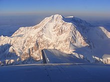
Map of Alaska Peninsula
The Alaska Peninsula (also called Aleut Peninsula or Aleutian Peninsula, Aleut: Alasxix̂; Sugpiaq: Aluuwiq, Al'uwiq) is a peninsula extending about 497 mi (800 km) to the southwest from the mainland of Alaska and ending in the Aleutian Islands. The peninsula separates the Pacific Ocean from Bristol Bay, an arm of the Bering Sea.
In literature (especially Russian), the term "Alaska Peninsula" was used to denote the entire northwestern protrusion of the North American continent, or all of what is now the state of Alaska, exclusive of its panhandle and islands. The Lake and Peninsula borough, the Alaskan equivalent of a county, is named after the peninsula. (Full article...) -
Fairbanks is a home rule city and the borough seat of the Fairbanks North Star Borough, Alaska, United States. Fairbanks is the largest city in the Interior region of Alaska and the second largest in the state. The 2020 Census put the population of the city proper at 32,515 and the population of the Fairbanks North Star Borough at 95,655, making it the second most populous metropolitan area in Alaska after Anchorage. The Metropolitan Statistical Area encompasses all of the Fairbanks North Star Borough and is the northernmost Metropolitan Statistical Area in the United States, located 196 miles (315 kilometers) by road (140 mi or 230 km by air) south of the Arctic Circle.
In August 1901, E.T. Barnette founded a trading post on the south bank of the Chena River. A gold discovery near the trading post sparked the Fairbanks Gold Rush, and many miners moved to the area. There was a boom in construction, and in November 1903 the area's residents voted to incorporate Fairbanks as a city. Barnette became the first mayor, and the city flourished during the gold rush. By World War I, the population had plunged, but rose again during the Great Depression as the price of gold increased. (Full article...) -

Chugach Census Area is a census area located in the state of Alaska, United States. It is part of the Unorganized Borough and therefore has no borough seat. On January 2, 2019, it was split from the Valdez–Cordova Census Area (of which it claims to be the successor), along with neighboring Copper River Census Area.
As of the 2020 census, the census area had a population of 7,102; its largest communities are the cities of Valdez and Cordova. (Full article...) -
-
Seward (Alutiiq: Qutalleq; Dena'ina: Tl'ubugh) is an incorporated home rule city in Alaska, United States. Located on Resurrection Bay, a fjord of the Gulf of Alaska on the Kenai Peninsula, Seward is situated on Alaska's southern coast, approximately 120 miles (190 km) by road from Alaska's largest city, Anchorage.
With a population of 2,717 people as of the 2020 census,
Seward is the fourth-largest city in the Kenai Peninsula Borough, behind Kenai, Homer, and the borough seat of Soldotna. The city is named for former United States Secretary of State William H. Seward, who orchestrated the United States' purchase of Alaska from the Russian Empire in 1867 while serving in this position as part of President Andrew Johnson's administration. (Full article...) -

Kenai Peninsula Borough is a borough of the U.S. state of Alaska. As of the 2020 census, the population was 58,799, up from 55,400 in 2010. The borough seat is Soldotna, the largest city is Kenai, and the most populated community is the census-designated place of Kalifornsky.
The borough includes most of the Kenai Peninsula and a large area of the mainland of Alaska on the opposite side of Cook Inlet. (Full article...) -
Ketchikan (/ˈkɛtʃɪkæn/ KETCH-ih-kan; Tlingit: Kichx̱áan) is a city in and the borough seat of the Ketchikan Gateway Borough of Alaska. It is the state's southeasternmost major settlement. Downtown Ketchikan is a National Historic Landmark District.
With a population at the 2020 census of 8,192, up from 8,050 in 2010, it is the sixth-most populous city in the state, and thirteenth-most populous community when census-designated places are included. The surrounding borough, encompassing suburbs both north and south of the city along the Tongass Highway (most of which are commonly regarded as a part of Ketchikan, albeit not a part of the city itself), plus small rural settlements accessible mostly by water, registered a population of 13,948 in that same census. (Full article...) -
Arctic Slope Regional Corporation, or ASRC, is one of 13 Alaska Native Regional Corporations created under the Alaska Native Claims Settlement Act of 1971 (ANCSA) in settlement of aboriginal land claims. ASRC was incorporated in Alaska on June 22, 1972. Headquartered in Utqiaġvik, Alaska, with administrative offices in Anchorage, ASRC was as of 2017, a for-profit corporation with nearly 11,000 Alaska Native shareholders primarily of Inupiat Eskimo descent. (Full article...) -
In a report compiled by the government of Alaska, the real GDP of Alaska was $51.1 billion in 2011, $52.9 billion in 2012 and $51.5 billion in 2013. The drop-off that occurred between 2012 and 2013 has been attributed to the decline in the mining sector, specifically the oil and gas sectors, a consequence of declined production. The state's economy has been described by University of Alaska Anchorage economist Scott Goldsmith as a "three-legged stool" - with one leg being the petroleum and gas industry, the second leg being the federal government and the third leg being all other industries and services. Between 2004 and 2006, the federal government was responsible for 135,000 Alaska jobs, the petroleum sector provided 110,000 jobs and all other industries and services combined for 122,000 jobs.
Alaska's main export product after oil and natural gas is seafood, primarily salmon, cod, pollock, and crab. In the 2013 fishing season, Alaskan fishers were able to accumulate a total of 5.8 billion pounds of seafood, which equates to an evaluation of $1.9 billion, a small, but noticeable increase in comparison to 2012, which had a total of 5.3 billion and $1.7 billion respectively. (Full article...) -
Hoonah–Angoon Census Area is a census area located in the U.S. state of Alaska. As of the 2020 census, the population was 2,365, up from 2,150 in 2010. It is part of the unorganized borough and therefore has no borough seat. Its largest community is the city of Hoonah. (Full article...) -
Nome Census Area is a census area located in the U.S. state of Alaska, mostly overlapping with the Seward Peninsula. As of the 2020 census, the population was 10,046, up from 9,492 in 2010. It is part of the unorganized borough and therefore has no borough seat. Its largest community by far is the city of Nome. (Full article...)


.jpg)


_(cropped).jpg)


Did you know...
- ... that Laura Bergt was said to have gained millions of acres of land for Native Alaskans by Eskimo-kissing Vice President Spiro Agnew?
- ... that until 1985, CBS programs on a TV station in Sitka, Alaska, were videotaped in Seattle and aired on a two-week delay?
- ... that Alaska marmots take turns acting as sentries to protect their colonies?
- ... that Mount Okmok in Alaska may have contributed to the downfall of Ptolemaic Egypt?
- ... that, according to its owner, KLEF in Anchorage, Alaska, was one of just three remaining commercially operated classical-music radio stations in the United States, as of 2013?
- ... that a man who threatened to blow up Alaska radio station KIAK unless he was put on the air was startled to find the station completely automated?
Need help?
Do you have a question about Alaska that you can't find the answer to?
Consider asking it at the Wikipedia reference desk.
Get involved
For editor resources and to collaborate with other editors on improving Wikipedia's Alaska-related articles, see WikiProject Alaska.
Selected images
-
-
 Köppen climate types of Alaska (from Alaska)
 -
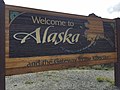 Alaska welcome sign on the Klondike Highway (from Alaska)
 -
 A line graph showing the presidential vote by party from 1960 to 2020 in Alaska (from Alaska)
 -
 Oil pooled on rocks on the shore of Prince William Sound after the 1989 Exxon Valdez oil spill. (from Alaska)
 -
 Utqiaġvik (Browerville neighborhood near Eben Hopson Middle School shown), known colloquially for many years by the nickname "Top of the World", is the northernmost city in the United States. (from Alaska)
 -

-
 Map of the largest racial/ethnic group by borough. Red indicates Native American, blue indicates non-Hispanic white, and green indicates Asian. Darker shades indicate a higher proportion of the population. (from Alaska)
 -
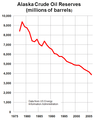 Alaska proven oil reserves peaked in 1973 and have declined more than 60% since then. (from Alaska)
 -

-

-
 A dog team in the Iditarod Trail Sled Dog Race, arguably the most popular winter event in Alaska (from Alaska)
 -
 U.S. troops navigate snow and ice during the Battle of Attu in May 1943. (from Alaska)
 -
 Alaskan oil production peaked in 1988 and has declined more than 75% since then. (from Alaska)
 -

-
 Fairbanks, Alaska's second-largest city and by a significant margin the largest city in Alaska's interior (from Alaska)
 -
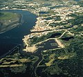
 Aerial view of infrastructure at the Prudhoe Bay Oil Field (from Alaska)
 -
 The Kachemak Bay Campus of the University of Alaska Anchorage, located in downtown Homer (from Alaska)
 -
 Alaska has more acreage of public land owned by the federal government than any other state. (from Alaska)
 -
 Alaska's size compared with the 48 contiguous states (Albers equal-area conic projection) (from Alaska)
 -
 The center of state government in Juneau. The large buildings in the background are, from left to right: the Court Plaza Building (known colloquially as the "Spam Can"), the State Office Building (behind), the Alaska Office Building, the John H. Dimond State Courthouse, and the Alaska State Capitol. Many of the smaller buildings in the foreground are also occupied by state government agencies. (from Alaska)
 -
 Bob Bartlett and Ernest Gruening, Alaska's inaugural U.S. Senators, hold the 49 star U.S. Flag after the admission of Alaska as the 49th state. (from Alaska)
 -
 The Trans-Alaska Pipeline transports oil, Alaska's most financially important export, from the North Slope to Valdez. The heat pipes in the column mounts are pertinent, since they disperse heat upwards and prevent melting of permafrost. (from Alaska)
 -
-

-
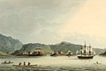 The Russian settlement of St. Paul's Harbor (present-day Kodiak town), Kodiak Island, 1814 (from Alaska)
 -
 The MV Tustumena (named after Tustumena Glacier) is one of the state's many ferries, providing service between the Kenai Peninsula, Kodiak Island and the Aleutian Chain. (from Alaska)
 -
 A Bombardier Dash 8, operated by Era Alaska, on approach to Ted Stevens Anchorage International Airport (from Alaska)
 -
 Alaska Interstate Highways (from Alaska)
 -
-
 Cordova, built in the early 20th century to support the Kennecott Mines and the Copper River and Northwestern Railway, has been preserved as a fishing community since their closure. (from Alaska)
 -

-
 An Aces game at "The Sully" (from Alaska)
 -
 Although entirely east of the International Date Line (the triangular kink in the line was agreed upon the US acquisition of Alaska), the Aleutian Islands cross the 180th meridian, such that they contain both the westernmost (Amatignak) and the easternmost (Semisopochnoi.) points in the United States. (from Alaska)
 -
 Ethnic origins in Alaska (from Alaska)
 -
-
-
-


.png)

.jpg)


.jpg)


.png)


In the news
- 23 April 2024 –
- A Douglas DC-4 crashes into the Tanana River in Alaska, United States, shortly after takeoff from Fairbanks, killing two people on board. (Anchorage Daily News)
Subcategories

- Select [►] to view subcategories
Topics

Associated Wikimedia
The following Wikimedia Foundation sister projects provide more on this subject:
-
 Commons
Free media repository -
 Wikibooks
Free textbooks and manuals -
 Wikidata
Free knowledge base -
 Wikinews
Free-content news -
 Wikiquote
Collection of quotations -
 Wikisource
Free-content library -
 Wikiversity
Free learning tools -
 Wiktionary
Dictionary and thesaurus