One Mile, Queensland
| One Mile Ipswich, Queensland | |||||||||||||||
|---|---|---|---|---|---|---|---|---|---|---|---|---|---|---|---|
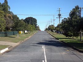
 Philip Street, 2016 | |||||||||||||||
| Coordinates | 27°38′06″S 152°44′28″E / 27.635°S 152.741°E | ||||||||||||||
| Population | 2,077 (2016 census)[1] | ||||||||||||||
| • Density | 944/km2 (2,450/sq mi) | ||||||||||||||
| Postcode(s) | 4305 | ||||||||||||||
| Area | 2.2 km2 (0.8 sq mi) | ||||||||||||||
| Location | |||||||||||||||
| LGA(s) | City of Ipswich | ||||||||||||||
| State electorate(s) | Ipswich West | ||||||||||||||
| Federal division(s) | Blair | ||||||||||||||
| |||||||||||||||
One Mile is a suburb of Ipswich in the City of Ipswich, Queensland, Australia.[2] At the 2016 census, the suburb recorded a population of 2,077. At that time, One Mile had an unemployment rate of 12.2%, nearly double that of the Australian unemployment rate of 6.9%.[1]
History
One Mile was known as Moopi Moopi Pa by the Quandamooka people.[3]
In 1943, after the closure of the Myora Mission, some of the residents were moved to One Mile; others went to Dunwich.[3]
The origin of the suburb name is from its approximate distance from the Ipswich CBD.[2] It was one mile from the centre of Ipswich to the crossing of the Bremer River on the road to Toowoomba (now the Old Toowoomba Road).[4] The bridge at this crossing was known as the One Mile Bridge until it was renamed the Don Livingstone One Mile Bridge in 2015 after Don Livingstone, a former Member of the Queensland Legislative Assembly for the local area.[5]
References
- ^ a b Australian Bureau of Statistics (27 June 2017). "One Mile (QLD) (State Suburb)". 2016 Census QuickStats. Retrieved 25 March 2018.
- ^ a b "One Mile – suburb (entry 45067)". Queensland Place Names. Queensland Government. Retrieved 22 June 2017.
- ^ a b Anderson, Robert V. (2001). "History, Life And Times of Robert Anderson: Gheebelum, Ngugi, Mulgumpin". doczz.net. Uniikup Productions. Retrieved 27 February 2020.
Community and personal history of a Ngugi Elder of Mulgumpin in Quandamooka, South East Queensland, Australia.
- ^ "Suburb and Place Names". Ipswich City Council. Archived from the original on 28 August 2018. Retrieved 4 November 2018.
- ^ Bennion, Brian (19 February 2015). "Bridge honour for Livingstone". Queensland Times. Archived from the original on 1 May 2016. Retrieved 4 November 2018.
External links

