
Tarn (department)
Tarn | |
|---|---|
   _-_Lac_du_Laouzas_-01.jpg) From top down, left to right: Albi and the Tarn River, old houses in Castres, street in Cordes-sur-Ciel and Lac du Laouzas | |
 Flag | |
 Location of Tarn in France | |
| Coordinates: 43°49′N 2°12′E / 43.817°N 2.200°E | |
| Country | France |
| Region | Occitanie |
| Departement | Since 4 March 1790 |
| Prefecture | Albi |
| Subprefecture | Castres |
| Government | |
| • President of the Departmental Council | Christophe Ramond (PS) |
| Area | |
| • Total | 5,757.9 km2 (2,223.1 sq mi) |
| Population (2017) | |
| • Total | 387,890 |
| • Rank | 62 |
| • Density | 67/km2 (170/sq mi) |
| Demonym | Tarnais |
| Time zone | UTC+1 (CET) |
| • Summer (DST) | UTC+2 (CEST) |
| ISO 3166 code | FR-81 |
| Department number | 81 |
| Arrondissements | 2 |
| Cantons | 23 |
| Communes | 314 |
| Website | http://www.tarn.fr |
Tarn (French pronunciation: [taʁn] or [ta:ʁ]; Occitan pronunciation: [taɾ]) is a department located in the Occitanie region of Southern France. Named after the river Tarn, it had a population of 387,890 as of 2017. Its prefecture and largest city is Albi. The inhabitants of Tarn are known, in French, as Tarnais and Tarnaises.[2]
History
Tarn is one of the original 83 departments created during the French Revolution on 4 March 1790, through application of the Law of 22 December 1789. It was created from part of the former province of Languedoc, and comprised the dioceses of Albi and Castres (which found themselves merged in 1817).
The new department had five districts: Albi, Castres, Lavaur, Gaillac, Lacaune. The capitals (now prefectures) were, alternatively, Albi and Castres but, from 1790 to 1797, the capital was only Albi; in 1797, the capital was moved to Castres.[3] In 1800, Albi became again the capital of the department and the arrondissements were created; the department had four arrondissements: Albi, Castres, Gaillac and Lavaur. In 1926, the arrondissements of Gaillac and Lavaur were eliminated.[3]
By the law of 28 Pluviôse Year 5, the departments of Hérault and of Tarn exchanged the canton of Anglès (which had been part of the diocese of Saint-Pons, but which has remained in Tarn) for that of Saint-Gervais-sur-Mare (which had been part of the diocese of Castres, but which today remains in Hérault).
Geography

Tarn is part of the Occitanie region and has an area of 5,757.9 km2 (2,223 sq mi).[1] The department is surrounded by 5 departments, all belonging to the region Occitanie: Hérault to the southeast, Aude to the south, Aveyron to the north and east, Haute-Garonne to the southwest and west, as well as Tarn-et-Garonne to the northwest.
The slope of the department is from east to west, and its general character is mountainous or hilly. Tarn's three principal ranges lying to the south-east are: the Mountains of Lacaune, the Sidobre and the Montagne Noire, belonging to the Cévennes.
The stony and wind-blown slopes of the Mountains of Lacaune (Monts de Lacaune) are used for pasture. The highest point of the range and of the department is the Puech Montgrand, 1,267 m (4,157 ft) high; several other summits are not much short of this. The granite-strewn plateaux of the Sidobre, from 490 to 610 m (1,600 to 2,000 ft) high, separate the valley of the river Agout from that of its western tributary, the Thoré River. The Montagne Noire, on the southwestern border of the department, derives its name from the forests on its northern slope. Its highest point is the Pic de Nore at 1,211 m (3,973 ft) high.
The limestone and sandstone foot-hills are clothed with vines and fruit trees, and are broken by deep alluvial valleys of particular fertility. With the exception of a small portion of the Montagne Noire, which drains into the river Aude, the whole department belongs to the basin of the Garonne.
Demographics
Tarn has a population, in 2017, of 387,890, for a population density of 67.4 inhabitants/km2. The arrondissement of Castres, with 195,817 inhabitants, is the arrondissement with more inhabitants. The arrondissement of Albi has 192,073 inhabitants.[4]
Population evolution
Population development since 1793:
|
| ||||||||||||||||||||||||||||||||||||||||||||||||||||||||||||||||||||||||||||||||||||
| source:[5] | |||||||||||||||||||||||||||||||||||||||||||||||||||||||||||||||||||||||||||||||||||||
Urban centres
The 10 largest cities in Tarn, with more than 6,000 inhabitants, are:
| City | Population (2017)[4] |
Arrondissement |
|---|---|---|
| Albi | 48,970 | Albi |
| Castres | 41,636 | Castres |
| Gaillac | 15,294 | Albi |
| Graulhet | 12,618 | Castres |
| Lavaur | 10,811 | Castres |
| Mazamet | 10,013 | Castres |
| Carmaux | 9,500 | Albi |
| Saint-Sulpice-la-Pointe | 9,117 | Castres |
| Saint-Juéry | 6,818 | Albi |
| Labruguière | 6,535 | Castres |
Administration
Administrative divisions
There are 2 arrondissements, 23 cantons and 314 communes in Tarn.
| Arrondissement | INSEE code | Capital | Population[4] (2017) |
Area (km2) |
Density (inhabitants/km2) |
Communes |
|---|---|---|---|---|---|---|
| Albi | 811 | Albi | 192,073 | 2,732 | 70.3 | 163 |
| Castres | 812 | Castres | 195,817 | 3,026 | 64.7 | 151 |
Politics
Departmental Council of Tarn
The Departmental Council of Tarn has 46 seats. In the 2015 departmental elections, the Socialist Party (PS) won 26 seats and The Republicans (LR) and Union of Democrats and Independents (UDI) alliance won 18 seats; two miscellaneous right candidates complete the assembly composition. Christophe Ramond (PS) has been President of the Departmental Council since 2017.
Members of the National Assembly
Tarn elected the following members of the National Assembly during the 2017 legislative election:
| Constituency | Member[6] | Party | |
|---|---|---|---|
| style="background-color: Template:Union of Democrats and Independents/meta/color" | | Tarn's 1st constituency | Philippe Folliot | Centrist Alliance |
| style="background-color: Template:La République En Marche!/meta/color" | | Tarn's 2nd constituency | Marie-Christine Verdier-Jouclas | La République En Marche! |
| style="background-color: Template:La République En Marche!/meta/color" | | Tarn's 3rd constituency | Jean Terlier | La République En Marche! |
Gallery
-

-
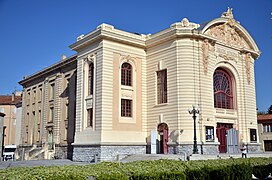 Castres municipal theatre
 -
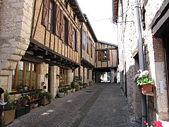 Street in Castelnau-de-Montmiral
 -
 View of Cordes-sur-Ciel


See also
- Cantons of the Tarn department
- Communes of the Tarn department
- Arrondissements of the Tarn department
- Tourism in Tarn
References
- ^ a b "Département du Tarn (81) – Résumé statistique". Publications et statistiques pour la France ou les régions (in French). Institut national de la statistique et des études économiques – INSEE. Retrieved 8 August 2015.
- ^ "Tarn (81)" (in French). habitants.fr. Retrieved 8 August 2015.
- ^ a b "Historique du Tarn". Le SPLAF (in French). Retrieved 8 August 2015.
- ^ a b c Téléchargement du fichier d'ensemble des populations légales en 2017, INSEE
- ^ Site sur la Population et les Limites Administratives de la France
- ^ http://www.assemblee-nationale.fr/
External links
- General Council website (in French)
- Prefecture website (in French)
- Discover Tarn – Comité Départemental du Tourisme du Tarn
- Photos of the Tarn (in French)
| International | |
|---|---|
| National | |
| Geographic | |
| Other | |