Atsugi
This article needs additional citations for verification. (August 2012) |
Atsugi
厚木市 | |
|---|---|
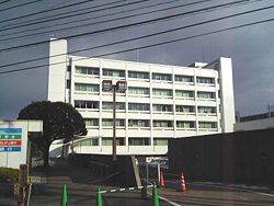
 Atsugi City Hall | |
 Location of Kiyokawa in Kanagawa Prefecture | |
| Country | Japan |
| Region | Kantō |
| Prefecture | Kanagawa Prefecture |
| District | Aikō (formerly) |
| Area | |
• Total | 93.83 km2 (36.23 sq mi) |
| Population (June 1, 2012) | |
• Total | 224,462 |
| • Density | 2,390/km2 (6,200/sq mi) |
| Time zone | UTC+9 (Japan Standard Time) |
| - Tree | Maple |
| - Flower | Rhododendron indicum |
| Phone number | 046-223-1511 |
| Address | 3-17-17 Nakacho, Atsugi-shi, Kanagawa-ken 243-8511 |
| Website | www |


Atsugi (厚木市, Atsugi-shi) is a city located in central Kanagawa Prefecture, Japan.
As of June 2012, the city has an estimated population of 224,462 and a population density of 2,390 persons per km². The total area is 93.83 km².
While the name “Atsugi” is often associated with the United States Navy base at Naval Air Facility Atsugi, the base is actually not in Atsugi, but straddles the border between the nearby cities of Ayase and Yamato.
Geography
Atsugi is located in the hilly center of Kanagawa Prefecture. Parts of the western portion of the city are within the Tanzawa-Ōyama Quasi-National Park and include Mount Ōyama
Surrounding municipalities
History
The area around present-day Atsugi city has been inhabited for thousands of years. Archaeologists have found ceramic shards from the Jōmon period at numerous locations in the area. By the Kamakura period, this area part of the Mōri shōen, part of the holdings of Ōe no Hiromoto. His descendants, the Mōri clan later ruled Chōshū domain. During the Kamakura period, the area was also known for its foundry industry for the production of bells for Buddhist temples. The area came under the control of the Ashikaga clan in the early Muromachi period and was later part of the territories of the Late Hōjō clan from Odawara. With the start of the Edo period, the area was tenryō territory controlled directly by the Tokugawa shogunate, but administered through various hatamoto, as well as exclaves under the control of Odawara Domain, Sakura Domain, Mutsuura Domain, Ogino-Yamanaka Domain and Karasuyama Domain. After the Meiji Restoration, the area was consolidated into Aikō District of Kanagawa Prefecture by 1876. Atsugi town was created on April 1, 1889 through merger of several small hamlets. Atsugi was elevated to city status on February 1, 1955 through merger with neighboring Mutsuai Village, Koaiyu Village, Tamagawa Village and Minamimori Village. The city expanded on July 8, 1958 through merger with neighboring Echi Village, and with Aikawa Village from Naka District. On September 30, 1956, Ogino Village joined with Atsugi. In April 2000, Atsugi exceeded 200,000 in population and was proclaimed a special city with increased autonomy from the central government.
Economy
Atsugi is mainly known as a bedroom community for the Tokyo-Yokohama metropolitan area. Nissan has operated a design center in Atsugi, Japan, since 1982.[1] Sony operates the Atsugi Technology Center and the Atsugi Technology Center No. 2 in Atsugi.[2] Anritsu is headquartered in Atsugi.
Transportation
Railroad
Atsugi is served by the Odakyu Odawara Line with connections to Shinjuku and Odawara. The main station is Hon-Atsugi Station, while Atsugi Station (on the Shinjuku side of the Sagami river) is located in nearby Ebina.
Highway
- Tōmei Expressway (toll) to Tokyo or Nagoya
- Japan National Route 129, to Hiratsuka or Sagamihara
- Japan National Route 246, to central Tokyo or Numazu
- Japan National Route 271, to Odawara (toll)
- Japan National Route 412, to Sagamiko
Sister City relations
 - Yokote, Akita, Japan, from May 24, 1985
 - Abashiri, Hokkaidō, Japan from February 5, 2005
 - New Britain, Connecticut, USA from May 31, 1983
 – Yangzhou. Jiangsu, China from October 23, 1984
 – Gunpo, Republic of Korea from February 5, 2005
Local attractions
- Iiyama Kannon (Chokokuji temple)
- Iiyama Spa
- Nanasawa Spa
- Mount Ōyama
Other institutions
- Aoyama Gakuin University
- Shoin University
- Nissan Technical Center
- Tokyo University of Agriculture Botanical Garden
- Kanagawa Institute of Technology
- Tokyo Polytechnic University, Atsugi, Kanagawa Campus
Noted people from Atsugi
- Akira Amari – politician
- Kyōko Koizumi – actress, singer
- Azusa Senou – singer
- Fujimaro Suzuki – actor
- Keiko Fujita – actress, model
- Marina Abe – actress, model
- Nobuteru Maeda – vocalist
- Yoshiyasu Ichikawa – singer, songwriter, producer
- Yurina Kumai – singer
- Sen Odagiri – newscaster
- Tatsunori Hara – former baseball player, manager of Yomiuri Giants
- Hitoshi Tamura - baseball player
- Teruyuki Moniwa – football player
- Genki Nagasato – football player
References
- ^ "Nissan Design Center." Retrieved on April 17, 2009.
- ^ "Access & Map." Sony. Retrieved on January 19, 2009.


