
Bissau
Bissau | |
|---|---|
 Downtown Bissau as seen from Pensão Central | |
 Flag  Coat of arms | |
| Country | |
| Region | Bissau Autonomous Sector |
| Area | |
| • Total | 30 sq mi (77 km2) |
| Population (2007) | |
| • Total | 407,424 est. |
| • Density | 13,704/sq mi (5,291.2/km2) |

Bissau is the capital city of Guinea-Bissau. The city's borders are conterminous with the Bissau Autonomous Sector. In 2007, the city had an estimated population of 407,424 according to the Instituto Nacional de Estatística e Censos.[1] The city which is located on the Geba River estuary, off the Atlantic Ocean, is the country's largest city, major port, administrative and military centre.
History
The city was founded in 1687 by Portugal as a fortified port and trading center. In 1942 it became the capital of Portuguese Guinea. After the declaration of independence by the anti-colonial guerrillas of PAIGC, in 1973, the capital of the de facto independent territories was declared to be Madina do Boe, but Bissau remained as the capital of the Portuguese-occupied regions, and the de jure capital of the entire Portuguese Guinea. When Portugal recognized the independence of Guinea-Bissau and pulled out in 1974 due to the military coup of April 25 in Lisbon, the two territories merged and Bissau became the capital of the new independent state. The city is known for its annual carnival.
Geography and climate
Bissau is located at 11°52' North, 15°36' West (11.86667, -15.60) [1], on the Geba River estuary, off the Atlantic Ocean. The land surrounding Bissau is extremely low-lying, and the river is accessible to ocean-going vessels despite its modest discharge for about 80 kilometres (50 mi) beyond the city.
Bissau has a tropical savanna climate (Köppen Aw), not quite wet enough to qualify as a tropical monsoon climate (Am) but much wetter than most climates of its type. Almost no rain falls from November to May, but during the remaining five months of the year the city receives around 2,020 millimetres (80 in) of rain, as compared to 3,784 millimetres (149.0 in) in Conakry and 1,296 millimetres (51.0 in) in Banjul to the north. During the wet season and even during the three months beforehand, high humidity makes heat discomfort extreme.
| Climate data for Bissau, Guinea-Bissau (1974-1994) | |||||||||||||
|---|---|---|---|---|---|---|---|---|---|---|---|---|---|
| Month | Jan | Feb | Mar | Apr | May | Jun | Jul | Aug | Sep | Oct | Nov | Dec | Year |
| Record high °C (°F) | 36.7 (98.1) |
38.3 (100.9) |
38.9 (102.0) |
41.1 (106.0) |
39.4 (102.9) |
35.6 (96.1) |
33.3 (91.9) |
32.8 (91.0) |
33.9 (93.0) |
34.4 (93.9) |
35.0 (95.0) |
35.6 (96.1) |
41.1 (106.0) |
| Mean daily maximum °C (°F) | 31.1 (88.0) |
32.8 (91.0) |
33.9 (93.0) |
33.3 (91.9) |
32.8 (91.0) |
31.1 (88.0) |
29.4 (84.9) |
30.0 (86.0) |
30.0 (86.0) |
31.1 (88.0) |
31.7 (89.1) |
30.6 (87.1) |
31.5 (88.7) |
| Mean daily minimum °C (°F) | 17.8 (64.0) |
18.3 (64.9) |
19.4 (66.9) |
20.6 (69.1) |
22.2 (72.0) |
22.8 (73.0) |
22.8 (73.0) |
22.8 (73.0) |
22.8 (73.0) |
22.8 (73.0) |
22.2 (72.0) |
18.9 (66.0) |
21.1 (70.0) |
| Record low °C (°F) | 12.2 (54.0) |
13.3 (55.9) |
15.6 (60.1) |
16.7 (62.1) |
17.2 (63.0) |
19.4 (66.9) |
19.4 (66.9) |
19.4 (66.9) |
19.4 (66.9) |
20.0 (68.0) |
15.0 (59.0) |
12.8 (55.0) |
12.2 (54.0) |
| Average rainfall mm (inches) | 0.5 (0.02) |
0.8 (0.03) |
0.5 (0.02) |
0.8 (0.03) |
17.3 (0.68) |
174.8 (6.88) |
472.5 (18.60) |
682.5 (26.87) |
434.9 (17.12) |
194.8 (7.67) |
41.4 (1.63) |
2.0 (0.08) |
2,022.8 (79.64) |
| Mean monthly sunshine hours | 248 | 226 | 279 | 270 | 248 | 210 | 186 | 155 | 180 | 217 | 240 | 248 | 2,707 |
| Source 1: Sistema de Clasificación Bioclimática Mundial [2] | |||||||||||||
| Source 2: World Climate Guides (sunshine only) [3] | |||||||||||||
Demographics
The last time an official census was held in the country, in 1991, the city/region had a population of 195,389. However, by 2007, the city had an estimated population of 407,424 according to the Instituto Nacional de Estatística e Censos.[1]
Economy
Bissau is the country's largest city, major port, educational, administrative and military center. Peanuts, hardwoods, copra, palm oil, and rubber are the chief products. The airport that serves Bissau is Osvaldo Vieira International Airport. Poverty and lack of development is widespread.
Landmarks
Attractions include the Portuguese-built Fortaleza de São José da Amura barracks from the 18th century, containing Amílcar Cabral's mausoleum, the Pidjiguiti Memorial to the dockers killed in the Bissau Dockers' Strike on August 3, 1959, the Guinea-Bissau National Arts Institute, Bissau New Stadium and local beaches. Many buildings in the city were ruined during the Guinea-Bissau Civil War (1998–1999), including the Guinea-Bissau Presidential Palace and the Bissau French Cultural Centre (now rebuilt), and the city centre is still underdeveloped.
-
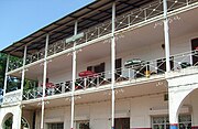 Pensão Central's colonial façade in downtown
 -
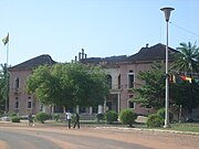 Ruins of the former presidential palace
 -
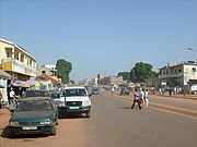 The road from the airport to the Parliament
 -
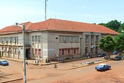 Central Post Office building
 -
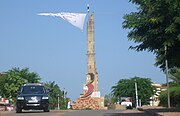 A landmark monument in the city center
 -
 PAIGC's headquarters


Sister cities
References
- ^ a b Instituto Nacional de Estatística e Censos
- ^ "GUINEA-BISSAU - BISSAU". Centro de Investigaciones Fitosociológicas. Retrieved 2011-10-04.
- ^ "Bissau Climate Guide". Centro de Investigaciones Fitosociológicas. Retrieved 2011-10-04.
- ^ "Geminação com Bissau e Gabu é reforço para lusofonia"
- Richard Andrew Lobban, Jr. and Peter Karibe Mendy, Historical Dictionary of the Republic of Guinea-Bissau, 3rd ed. (Scarecrow Press, 1997, ISBN 0-8108-3226-7) pp. 91–96
|  | |||||||||||||||||||||||||||||||||||||||||||||||||||||||||||||||||||||||
|
| ||||||||||||||||||||||||||||||||||||||||||||||||||||||||||||||||||||||||
| ||||||||||||||||||||||||||||||||||||||||||||||||||||||||||||||||||||||||
| ||||||||||||||||||||||||||||||||||||||||||||||||||||||||||||||||||||||||
| ||||||||||||||||||||||||||||||||||||||||||||||||||||||||||||||||||||||||
| ||||||||||||||||||||||||||||||||||||||||||||||||||||||||||||||||||||||||