Campo Belo
You can help expand this article with text translated from the corresponding article in Portuguese. (April 2013) Click [show] for important translation instructions.
|
Error: no context parameter provided. Use {{other uses}} for "other uses" hatnotes. (help).
Campo Belo | |
|---|---|
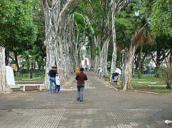
 View of Campo Belo's main square | |
| Motto(s): Portuguese: União, Ordem e Progresso (Union, Order and Progress) | |
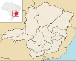
 Location in Brazil | |
| Country | |
| Region | Southeast |
| State | Minas Gerais |
| Mesoregion | West of Minas Gerais |
| Microregion | Campo Belo |
| Founded | 1879 |
| Government | |
| • Mayor | Tulio Miguel |
| Area | |
| • Total | 526,753 km2 (203,380 sq mi) |
| Elevation | 945.0 m (3,100.4 ft) |
| Population (2006)[1] | |
| • Total | 52,631 |
| • Density | 97.58/km2 (252.7/sq mi) |
| Demonym | Campo-belense[2] |
| Time zone | UTC-3 (BRT) |
| • Summer (DST) | UTC-2 (BRST) |
| HDI (2010) [3] | 0.711 |
| Website | Campo Belo, Minas Gerais |
Campo Belo (Portuguese for "beautiful field") is a city located in Minas Gerais state, in Brazil. The estimated population in 2006 was 52.631 inhabitants and the total area of the municipality was 526,753 km². It was founded in 1879.
Geography
Climate
Campo Belo's climate can be classified as tropical altitude, with yearly average temperature of 23.5°C. The Köppen climate classification of the region is Cwa (Tropical on high altitudes, humid/warm summer and a dry/cool winter).
| Campo Belo | ||||||||||||||||||||||||||||||||||||||||||||||||||||||||||||
|---|---|---|---|---|---|---|---|---|---|---|---|---|---|---|---|---|---|---|---|---|---|---|---|---|---|---|---|---|---|---|---|---|---|---|---|---|---|---|---|---|---|---|---|---|---|---|---|---|---|---|---|---|---|---|---|---|---|---|---|---|
| Climate chart (explanation) | ||||||||||||||||||||||||||||||||||||||||||||||||||||||||||||
| ||||||||||||||||||||||||||||||||||||||||||||||||||||||||||||
| ||||||||||||||||||||||||||||||||||||||||||||||||||||||||||||
Soil
- Silic - Clay.
Topography
- Plain : 15%
- Waivy : 55%
- Mountain: 30%
References
- ^ "Estimativas das Populações Residentes, em 01.07.2006, Segundo os Municípios" (PDF) (in Portuguese). IBGE. Retrieved 2006-09-01.
- ^ "IBGE - Cidades@". O Brasil Município por Município. Brazilian Institute of Geography and Statistics (IBGE). Retrieved 2015-05-27.
- ^ "Ranking decrescente do IDH-M dos municípios do Brasil" (PDF) (in Portuguese). United Nations Development Programme (UNDP). 2010. Retrieved 2013-08-03.
{{cite web}}: Unknown parameter|trans_title=ignored (|trans-title=suggested) (help)
Wikimedia Commons has media related to Campo Belo.


