
Katihar Junction railway station
Katihar Junction | |
|---|---|
| Express train and Passenger train station | |
| General information | |
| Location | Station Road, Katihar, Bihar-854105 India |
| Coordinates | 25°32′55″N 87°33′58″E / 25.54869°N 87.56615°E |
| Elevation | 35 metres (115 ft) |
| Owned by | Indian Railways |
| Operated by | Northeast Frontier Railway |
| Line(s) | Barauni-Katihar section, Barauni-Guwahati line Katihar-Siliguri line Katihar-Malda Town line Katihar-Jogbani line Katihar-Manihari-Teznarayanpur line |
| Platforms | 7 |
| Tracks | 10 |
| Construction | |
| Structure type | Standard (on ground station) |
| Parking | Available |
| Other information | |
| Status | Functioning |
| Station code | KIR |
| Zone(s) | North East Frontier Railway |
| Division(s) | Katihar |
| History | |
| Opened | 1889 |
| Electrified | Electrified(April-2017) |
| Previous names | East Indian Railway |
| Passengers | |
| 1 Lakh per day | |
Katihar Junction railway station serves Katihar city in Katihar district in the Indian state of Bihar. The Katihar Junction railway station is connected to most of the major cities in India by the railway network.
Katihar lies in between Barauni-Katihar section of Barauni-Guwahati line
Katihar-Siliguri line which serves the city with numerous number of trains to Guwahati, Kolkata, Delhi, Dalkhola and with many other cities.
History
East Indian Railway Company (EIR) opened the Manihari-Katihar-Kasba section in 1888 and the North Bengal Railway opened the Katihar-Raiganj section the same year. EIR opnened the Barsoi-Kishanganj section in 1889. All these lines were 1,000 mm (3 ft 3+3⁄8 in) wide metre gauge lines. Darjeeling Himalayan Railway, operating 2 ft (610 mm) narrow gauge lines, extended their operations from Siliguri to Kishanganj in 1915 and to Dalkhola.
Siliguri was connected to Kolkata via the eastern part of Bengal since 1878 (for details see Howrah-New Jalpaiguri Line). However, with the partition of India in 1947, railway services in the region were completely disrupted. In 1949, the narrow gauge Siliguri-Kishanganj section was upgraded to metre gauge. Thus there was a direct metre gauge connection from Manihari to Siliguri via Katihar.[1] The importance of Katihar station grew because of the jute mill in the region.
Development
In the early 1960s, when Farakka Barrage was being constructed, Indian Railways took the initiative to extend 1,676 mm (5 ft 6 in) wide broad gauge rail link from Kolkata.[1]
The 2,240 m (7,350 ft) long Farakka Barrage carries a rail-cum-road bridge across the Ganges. The rail bridge was opened in 1971 thereby linking the Barharwa-Azimganj-Katwa loop to Malda, New Jalpaiguri and other railway stations in North Bengal.[2][3]
Gauge conversion work (from metre gauge to broad gauge) in the Barauni–Katihar section was taken up in 1978-79 and completed in 1982.[4]
The Siliguri-Katihar line was the last surviving metre gauge line in the area. The Aluabari Road-Katihar section already had a broad gauge line running alongside the metre gauge line. The Aluabari Road-Siliguri section needed to be converted. Conversion work was taken up in 2008, train services in the section was suspended and conversion work completed early in 2011.[5][6][7]
Platforms
There are 7 functional platforms at Katihar junction which are interconnected & have multiple Foot over bridges (FOB).
Gallery
-
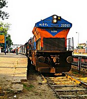
 Katihar Station
 -
 Kamakhya - Lokmanya Tilak Terminus AC Express entering Katihar
 -
 12423 Dibrugarh - New Delhi Rajdhani Express waiting to depart Katihar
 -
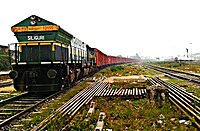 A Siliguri-based WDG4 with a Freight Train enters Katihar Junction


References
- ^ a b "India: the complex history of the junctions at Siliguri and New Jalpaiguri". IRFCA. Retrieved 12 November 2011.
- ^ R.P.Saxena. "Indian Railway History timeline". Archived from the original on 14 July 2012. Retrieved 20 November 2011.
{{cite web}}: Unknown parameter|deadurl=ignored (|url-status=suggested) (help) - ^ Salman, Salman M. A.; Uprety, Kishor (2002). Conflict and cooperation on South Asia's international rivers: a legal perspective. World Bank Publications. pp. 135–136. ISBN 978-0-8213-5352-3. Retrieved 5 July 2011.
- ^ Rajendra Saxena. "Details of New line, Gauge conversion & Doubling constructed after independence & in progress on Indian Railways". item No. 18. irse. Retrieved 24 January 2012.
- ^ "Delayed but new route helps trains". The Telegraph, 29 September 2011. Retrieved 10 December 2011.
- ^ "Railways to partially restore Siliguri-Bagdogra service". Times of India, 16 March 2010. 16 March 2010. Retrieved 10 December 2011.
- ^ "IRFCA photo gallery". IRFCA. Retrieved 10 December 2011.
External links
- Katihar Junction railway station at the India Rail Info
| Preceding station | Indian Railway | Following station | ||
|---|---|---|---|---|
| Terminus | Template:Indian Railways lines | |||
| Terminus | Template:Indian Railways lines | |||
| Terminus | Template:Indian Railways lines | |||
| Terminus | Template:Indian Railways lines | |||
| Terminus | Template:Indian Railways lines |