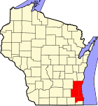
Milwaukee County, Wisconsin
Milwaukee County | |
|---|---|
 Location within the U.S. state of Wisconsin | |
 Wisconsin's location within the U.S. | |
| Coordinates: 43°00′00″N 87°58′02″W / 43°N 87.9671°W | |
| Country | |
| State | |
| Seat | Milwaukee |
| Population (2006) | |
• Total | 915,097 |
| Website | www |
Milwaukee County is a county in the U.S. state of Wisconsin. As of 2006, the population was 915,097. Its county seat is Milwaukee6.
Geography
According to the U.S. Census Bureau, the county has a total area of 3,081 km² (1,190 mi²). 626 km² (242 mi²) of it is land and 2,456 km² (948 mi²) of it (79.70%) is water.
Adjacent counties
- Ozaukee County - north
- Racine County - south
- Waukesha County - west
- Washington County - northwest
Demographics

| Census | Pop. | Note | %± |
|---|---|---|---|
| 1850 | 31,077 | — | |
| 1860 | 62,518 | 101.2% | |
| 1870 | 89,930 | 43.8% | |
| 1880 | 138,537 | 54.0% | |
| 1890 | 236,101 | 70.4% | |
| 1900 | 330,017 | 39.8% | |
| 1910 | 433,187 | 31.3% | |
| 1920 | 539,449 | 24.5% | |
| 1930 | 725,263 | 34.4% | |
| 1940 | 766,885 | 5.7% | |
| 1950 | 871,047 | 13.6% | |
| 1960 | 1,036,041 | 18.9% | |
| 1970 | 1,054,063 | 1.7% | |
| 1980 | 964,988 | −8.5% | |
| 1990 | 959,275 | −0.6% | |
| 2000 | 921,654 | −3.9% | |
| 2006 (est.) | 915,097 | [1] | |
| Source: U.S. Census[2] | |||
As of the census² of 2005, there were 921,654 people, 377,729 households, and 225,126 families residing in the county. The population density was 1,503/km² (3,892/mi²). There were 400,093 housing units at an average density of 640/km² (1,656/mi²). The racial makeup of the county was 65.62% White, 24.59% Black or African American, 0.72% Native American, 2.57% Asian, 0.04% Pacific Islander, 4.25% from other races, and 2.21% from two or more races. 8.77% of the population were Hispanic or Latino of any race. 25.0% were of German, 10.9% Polish and 5.3% Irish ancestry according to Census 2000.
There were 377,729 households out of which 29.50% had children under the age of 18 living with them, 39.00% were married couples living together, 16.30% had a female householder with no husband present, and 40.40% were non-families. 33.00% of all households were made up of individuals and 10.70% had someone living alone who was 65 years of age or older. The average household size was 2.43 and the average family size was 3.13.
In the county, the population was spread out with 26.40% under the age of 18, 10.50% from 18 to 24, 30.30% from 25 to 44, 20.00% from 45 to 64, and 12.90% who were 65 years of age or older. The median age was 34 years. For every 100 females there were 92.00 males. For every 100 females age 18 and over, there were 88.10 males.
Government
- County Executive: Scott Walker (R)
- District Attorney: John T. Chisholm (D)
- Sheriff: David Clarke (D)
- Register of Deeds: John La Fave (D)
- Board of Supervisors (19 members) [[1]
- Milwaukee County Board
Transportation
Bus service in Milwaukee County is provided by the Milwaukee County Transit System, which operates 469 New Flyer and 5 Gillig Low Floor buses on 56 routes. The transit system received an additional nine buses in 2006.
Cities and towns
- Bayside
- Brown Deer
- Cudahy
- Fox Point
- Franklin
- Glendale
- Greendale
- Greenfield
- Hales Corners
- Milwaukee
- Oak Creek
- River Hills
- Shorewood
- South Milwaukee
- St. Francis
- Wauwatosa
- West Allis
- West Milwaukee
- Whitefish Bay
References
- ^ "Wisconsin by County - GCT-T1. Population Estimates". American FactFinder. U.S. Census Bureau. Retrieved 2007-04-09.
- ^ Southeastern Wisconsin Regional Planning Commission (July 2004). "The Population of Southeastern Wisconsin" (PDF). Technical Report Number 11 (4th Edition). Retrieved 2007-04-09.
{{cite journal}}: Cite journal requires|journal=(help)

