
Oblasts of Ukraine
| Oblasts of Ukraine | |
|---|---|

| |
| Category | Subdivision of a unitary state |
| Location | |
| Created |
|
| Number | 24 (as of 1991) |
| Populations | 904,000 (Chernivtsi) – 4,450,000 (Donetsk) |
| Areas | 8,100 km2 (3,126 sq mi) (Chernivtsi) – 33,300 km2 (12,860 sq mi) (Odessa) |
| Government |
|
| Subdivisions | |
An oblast (Ukrainian: область), in English referred to as a region, refers to one of Ukraine's 24 primary administrative units. Ukraine is a unitary state, thus, the regions do not have much legal scope of competence other than that which is established in the Ukrainian Constitution and by law. Articles 140-146 of Chapter XI of the constitution deal directly with local authorities and their competency.
Oblasts are further subdivided into raions (districts), ranging in number from 11 to 27 per entity.[1]
General characteristics
| Part of a series on the |
| Subdivisions of Ukraine |
|---|
 |
| First level |
| Second level |
| Third level |
In Ukraine the term Oblast denotes a primary administrative division. Under the Russian Empire and into the 1920s, Ukraine was divided between several Governorates. The term oblast itself was first introduced in 1932 by Soviet authorities when the Ukrainian SSR was divided into seven oblasts replacing the previous subdivision system based on okruhas and encompassing 406 raions (districts).[2] The first oblasts were Vinnytsia Oblast, Kiev Oblast, Odessa Oblast, Kharkiv Oblast, and Dnipropetrovsk Oblast. Soon after that in the summer of 1932 Donetsk Oblast was formed out of eastern parts of Kharkiv and Dnipropetrovsk oblasts; in the fall of 1932 Chernihiv Oblast was formed on the border of Kiev and Kharkiv oblasts.
Between 1935–1938 there existed several newly created and self-governed special border okrugs located along the western border of the Soviet Union in Ukraine and Belarus. Upon liquidation of the okrugs in 1937-38 Kiev, Vinnytsia, Odessa, and Kharkiv oblasts were each split into four additional oblasts (Zhytomyr Oblast, Kamianets-Podilsky Oblast (later – Khmelnytskyi), Mykolaiv Oblast, Poltava Oblast). Just before the World War II, the Donetsk Oblast was split into Stalino Oblast and Voroshylovhrad Oblast and the Kirovohrad Oblast was created out of portions of Kiev, Mykolaiv and Odessa oblasts.
During World War II Ukraine added eight additional oblasts of the West Ukraine and Bessarabia. Upon the occupation of Ukraine by the Nazi Germany the territory was split between General Government, Kingdom of Romania and Reichskommissariat Ukraine and carried out a completely different administrative division, see Reichskommissariat Ukraine. With the re-establishing of the Soviet power in the state after the war, the administrative division by oblast was resumed adding one more oblast—Zakarpattia. In 1954, the Crimean Oblast was transferred from the Russian Soviet Federative Socialist Republic to the Ukrainian SSR; parts of the surrounding oblasts were incorporated into the Cherkasy Oblast, while Izmail Oblast was absorbed by Odessa Oblast. In 1959, Drohobych Oblast was merged with Lviv Oblast.
Most of Ukraine's oblasts are named after their respective administrative centers, which are also the largest and most developed city in a given region. Each region generally consists of about one to two million of people, ranging anywhere from as low as 904,000 in Chernivtsi Oblast to 4.4 million in the eastern oblast of Donetsk. Each oblast is generally subdivided into about 20 raions (mean average, can range anywhere from 11 in Chernivtsi to 27 in Kharkiv and Vinnytsia Oblasts).
First oblasts of Ukraine in 1932
- Dnipropetrovsk Oblast, centered in Dnipropetrovsk (subdivided into raions)
- Kharkiv Oblast, centered in Kharkiv (subdivided into raions)
- Kiev Oblast, centered in Kiev (subdivided into raions)
- Odessa Oblast, centered in Odessa (subdivided into raions)
- Vinnytsia Oblast, centered in Vinnytsia (subdivided into raions)
- raions of republican subordination (directly to Kharkiv)
- Later there were added
- Donetsk Oblast, centered in Stalino (initially – Artemivsk) (created on 17 July 1932 out of raions of Kharkiv and Dnipropetrovsk oblasts and raions of republican subordination)
- Chernihiv Oblast, centered in Chernihiv (created on 15 October 1932 out of raions of Kharkiv and Kiev oblasts)
Further division in 1937-38
- Kamianets-Podilsk Oblast, centered in Kamianets-Podilsk (out of raions of Vinnytsia Oblast)
- Mykolaiv Oblast, centered in Mykolaiv (out of raions of Odessa and Dnipropetrovsk oblasts)
- Poltava Oblast, centered in Poltava (out of raions of Kharkiv and Kiev oblasts)
- Zhytomyr Oblast, centered in Zhytomyr (out of raions of Vinnytsia and Kiev oblasts)
- In 1938 there were added
- Donetsk Oblast was split in two Stalino Oblast, centered in Stalino and Voroshylovhrad Oblast, centered in Voroshylovhrad
New creations and World War II territorial expansions in 1939-40
- Kirovohrad Oblast, centered in Kirovohrad (out of raions of Kiev, Odessa, Poltava and Mykolaiv oblasts)
- Sumy Oblast, centered in Sumy (out of raions of Chernihiv, Poltava and Kharkiv oblasts)
- Zaporizhia Oblast, centered in Zaporizhia (out of raions of Dnipropetrovsk and Mykolaiv oblasts)
- Drohobych Oblast, centered in Drohobych
- Ivano-Frankivsk Oblast, centered in Ivano-Frankivsk
- Lviv Oblast, centered in Lviv
- Volyn Oblast, centered in Lutsk
- Rovno Oblast, centered in Rovno
- Tarnopol Oblast, centered in Tarnopol
- In 1940 there were added
- Chernivtsi Oblast, centered in Chernivtsi
- Izmail Oblast, centered in Izmail
Post World War II
- Kherson Oblast, centered in Kherson
- Zakarpattia Oblast, centered in Uzhhorod
- Cherkasy Oblast, centered in Cherkasy
- Crimean Oblast, centered in Simferopol
Maps
-
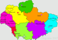
 Map of the Okruhas of Ukraine in 1929—1930.
 -
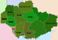
 After 1935; including recently created Donetsk and Chernihiv Oblasts and border okrugs.
 -
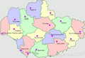
 Border okrugs are liquidated and created four additional oblasts in 1937.
 -
 Creation of additional oblasts just before World War II.
 -
 Post war divisions of Ukraine.


Constitutional provisions and authority
The Ukrainian constitution establishes Ukraine as a unitary state. The specific text of the constitution that refers to the territorial structure is as follows.
The territorial structure of Ukraine is based on the principles of unity and indivisibility of the state territory, the combination of centralisation and decentralisation in the exercise of state power, and the balanced socio-economic development of regions that takes into account their historical, economic, ecological, geographical and demographic characteristics, and ethnic and cultural traditions.

Each of Ukraine's oblasts have their own legislative and executive authority, most of which is subordinate to the central government authorities in Kiev. Each region is administered under laws passed by the Ukrainian government and the Constitution of Ukraine. Each region levies its own taxes and, in return, receive a portion of their budget from Kiev, which gives them a portion of the taxes they levy.[3]
Executive power each of the oblasts (as well as in other subdivisions of Ukraine) are exercised by local elected administrations.[4] The heads of local administrations are in turn appointed and dismissed by the President of Ukraine upon nomination by the Cabinet of Ministers.[4][5] Since Ukraine is a unitary state, there is little true political power and weight that these local administrations actually hold. Carrying out their authorities, the heads of local administrations are accountable to the President and are subordinate to higher bodies of executive leadership.[4]
Legislative power in the oblast governments is exercised by their respective oblast councils, which in turn supervise the activities of local administrations.[4] They also have considerable budgets managed by an oblast council (Ukrainian: обласна рада) made up of people's deputies (representatives) voted into office in regional elections every 4 years, the last of which took place in 2010.
Nomenclature
The name of each oblast is a relative adjective, formed by adding a feminine suffix to the name of respective center city. E.g. Poltava is a center of Poltavs'ka oblast' (Poltava Oblast). Most of them are also sometimes referred to in a feminine noun form, following the convention of traditional regional place names, ending with the suffix "-shchyna". E.g. Poltava Oblast is also called Poltavshchyna.
Exceptions to this rule include:
- Two oblasts, Volyn and Zakarpattia, which retain the names of their respective historical regions, Volyn' (Volhynia) and Zakarpattia (Transcarpathia), whose respective capitals are Lutsk and Uzhhorod.[6]
- The capital cities of the Dnipropetrovsk Oblast and Kirovohrad Oblast were renamed to Dnipro and Kropyvnytskyi in 2016 as part of a process of replacing Soviet toponyms. However as the names of the oblasts are mentioned in the Ukrainian Constitution changing them requires a complicated and lengthy process, thus as of 2017 the two oblasts still formally retain their soviet names.[7]
List of former and renamed oblasts

Former Oblasts
- Izmail Oblast (initially as Akkerman Oblast) existed in 1940–41 and 1944–54 (under Romanian occupation, later was added to Odessa Oblast)
- Drohobych Oblast existed in 1939–1941 and 1944–1959 (under German occupation, it was merged into Lviv Oblast)
- Crimean Oblast (1954–1991) was transformed into Crimean ASSR
Renamed Oblasts
- Stalino Oblast was the name of Donetsk Oblast 1938-41 and 1943-61 (created out of the united Donetsk Oblast 1932–38, German occupation 1941–43)
- Akkerman Oblast was the name of Izmail Oblast 1940
- Stanislav Oblast was the name of Ivano-Frankivsk Oblast 1939–41 and 1944–62 (German occupation 1941–44)
- Kamianetsk-Podilska Oblast was the name of Khmelnytskyi Oblast 1937-41 and 1944-54 (German occupation 1941–44, later transfer of administrative center to Khmelnytskyi)
- Voroshylovhrad Oblast was the name of Luhansk Oblast 1938–42, 1943–58 and 1970–90 (German occupation 1942–43)
- Tarnopil Oblast was the name of Ternopil Oblast 1939–41 (renamed soon after World War II)
The Dnipropetrovsk Oblast and Kirovohrad Oblast are pending renaming following the renaming of their capital cities to Dnipro and Kropyvnytskyi.
List of oblasts
| Region | HASC | Area (km2) | Population (2010) | Pop. density | Administrative center | Raions/Districts | Cities of regional significance [nb 2] |
|---|---|---|---|---|---|---|---|
| CK | 20,891 | 1,291,135 | 61.80 | Cherkasy | 20 | 6 | |
| CH | 31,851.3 | 1,104,241 | 34.67 | Chernihiv | 22 | 3 | |
| CV | 8,093.6 | 903,782 | 111.67 | Chernivtsi | 11 | 2 | |
| DP | 31,900.5 | 3,344,073 | 104.83 | Dnipro | 22 | 13 | |
| DT | 26,505.7 | 4,448,031 | 167.81 | Donetsk | 18 | 28 | |
| IF | 13,894.0 | 1,380,770 | 99.38 | Ivano-Frankivsk | 14 | 5 | |
| KK | 31,401.6 | 2,755,177 | 87.74 | Kharkiv | 27 | 7 | |
| KS | 28,449 | 1,091,151 | 38.35 | Kherson | 18 | 3 | |
| KM | 20,636.2 | 1,331,534 | 64.52 | Khmelnytskyi | 20 | 6 | |
| KV | 28,118.9 | 1,719,602 | 61.15 | Kiev | 25 | 13 | |
| KH | 24,577.5 | 1,014,809 | 41.29 | Kropyvnytskyi | 21 | 4 | |
| LH | 26,672.5 | 2,300,412 | 86.25 | Luhansk | 18 | 14 | |
| LV | 21,823.7 | 2,545,634 | 116.65 | Lviv | 20 | 9 | |
| MY | 24,587.4 | 1,186,452 | 48.25 | Mykolaiv | 19 | 5 | |
| OD | 33,295.9 | 2,387,636 | 71.71 | Odessa | 26 | 7 | |
| PL | 28,735.8 | 1,493,668 | 51.98 | Poltava | 25 | 5 | |
| RV | 20,038.5 | 1,152,576 | 57.52 | Rivne | 16 | 4 | |
| SM | 23,823.9 | 1,166,765 | 48.97 | Sumy | 18 | 7 | |
| TP | 13,817.1 | 1,086,694 | 78.65 | Ternopil | 17 | 1 | |
| VI | 26,501.6 | 1,646,250 | 62.12 | Vinnytsia | 27 | 6 | |
| VO | 20,135.3 | 1,038,223 | 51.56 | Lutsk | 16 | 4 | |
| ZK | 12,771.5 | 1,246,323 | 97.59 | Uzhhorod | 13 | 5 | |
| ZP | 27,168.5 | 1,805,431 | 66.45 | Zaporizhia | 20 | 5 | |
| ZT | 29,819.2 | 1,283,201 | 43.03 | Zhytomyr | 23 | 5 |
See also
- Administrative divisions of Ukraine
- Ukrainian historical regions
- List of etymologies of country subdivision names: "Ukraine"
References
- Notes
- ^ A total of 490 raions exist within the first-level subdivisions of Ukraine, including the 24 oblasts and the Autonomous Republic of Crimea.
- ^ "cities of oblast significance" is a translation of Ukrainian: Міста обласного значення.
- Footnotes
- ^ Decrees of Kiev City Council Archived 2007-07-07 at the Wayback Machine Kiev City Council decree No. 280/1257: Description of New Administrative Raions of the City of Kyiv. Passed on 2001-04-27. Template:Uk icon
- ^ "Ukraine Regions". Statoids. Retrieved 25 December 2011.
- ^ Constitution of Ukraine, Chapter IX: Territorial Structure of Ukraine, Article 143
- ^ a b c d "The Constitution of Ukraine". pravnyk.info (in Ukrainian). Retrieved 25 December 2011.
- ^ Poroshenko to sign Saakashvili’s resignation if Cabinet submits motion, Interfax-Ukraine (7 November 2016)
- ^ "Ukraine". The World Factbook. Central Intelligence Agency. Retrieved 25 December 2011.
- ^ Ukraine, The World Factbook
External links
- "Regions of Ukraine and their composition". Verkhovna Rada of Ukraine (in Ukrainian). Retrieved 25 December 2011.
- "Territorial Division of Ukraine". pidruchniki.ws (in Ukrainian). Retrieved 25 December 2011.
- Handbook on history of the Communist Party and the Soviet Union