Portal:Tropical cyclones
The Tropical Cyclones Portal
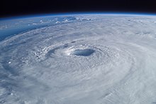
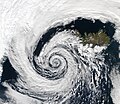
A tropical cyclone is a storm system characterized by a large low-pressure center, a closed low-level circulation and a spiral arrangement of numerous thunderstorms that produce strong winds and heavy rainfall. Tropical cyclones feed on the heat released when moist air rises, resulting in condensation of water vapor contained in the moist air. They are fueled by a different heat mechanism than other cyclonic windstorms such as Nor'easters, European windstorms and polar lows, leading to their classification as "warm core" storm systems. Most tropical cyclones originate in the doldrums, approximately ten degrees from the Equator.
The term "tropical" refers to both the geographic origin of these systems, which form almost exclusively in tropical regions of the globe, as well as to their formation in maritime tropical air masses. The term "cyclone" refers to such storms' cyclonic nature, with anticlockwise rotation in the Northern Hemisphere and clockwise rotation in the Southern Hemisphere. Depending on its location and intensity, a tropical cyclone may be referred to by names such as "hurricane", "typhoon", "tropical storm", "cyclonic storm", "tropical depression" or simply "cyclone".
Types of cyclone: 1. A "Typhoon" is a tropical cyclone located in the North-west Pacific Ocean which has the most cyclonic activity and storms occur year-round. 2. A "Hurricane" is also a tropical cyclone located at the North Atlantic Ocean or North-east Pacific Ocean which have an average storm activity and storms typically form between May 15 and November 30. 3. A "Cyclone" is a tropical cyclone that occurs in the South Pacific and Indian Oceans.
Selected named cyclone -
Intense Tropical Cyclone Idai (/ɪˈdaɪ, ˈiːdaɪ/) was one of the worst tropical cyclones on record to affect Africa and the Southern Hemisphere. The long-lived storm caused catastrophic damage, and a humanitarian crisis in Mozambique, Zimbabwe, and Malawi, leaving more than 1,500 people dead and many more missing. Idai is the deadliest tropical cyclone recorded in the South-West Indian Ocean basin. In the Southern Hemisphere, which includes the Australian, South Pacific, and South Atlantic basins, Idai ranks as the second-deadliest tropical cyclone on record. The only system with a higher death toll is the 1973 Flores cyclone that killed 1,650 off the coast of Indonesia.
The tenth named storm, seventh tropical cyclone, and seventh intense tropical cyclone of the 2018–19 South-West Indian Ocean cyclone season, Idai originated from a tropical depression that formed off the east coast of Mozambique on 4 March 2019. The storm, Tropical Depression 11, made landfall in Mozambique later in the day and remained a tropical depression through its five-day trek over land. On 9 March, the depression re-emerged into the Mozambique Channel and strengthened into Moderate Tropical Storm Idai on the next day. Idai then began a stint of rapid intensification, reaching an initial peak intensity as an intense tropical cyclone, with sustained winds of 175 km/h (109 mph) on 11 March. Idai then began to weaken, due to ongoing structural changes within its inner core, falling to tropical cyclone intensity. Idai's intensity remained stagnant for about a day or so before it began to re-intensify. On 14 March, Idai reached its peak intensity, with maximum sustained winds of 195 km/h (121 mph) and a minimum central pressure of 940 hPa (27.76 inHg). Idai then began to weaken as it approached the coast of Mozambique, due to less favourable conditions, weakening below intense tropical cyclone status later that day. On 15 March, Idai made landfall near Beira, Mozambique, subsequently weakening into a remnant low on 16 March. Idai's remnants slowly continued inland for another day, before reversing course and turning eastward on 17 March. On 19 March, Idai's remnants re-emerged into the Mozambique Channel and eventually dissipated on 21 March. (Full article...)Selected article -
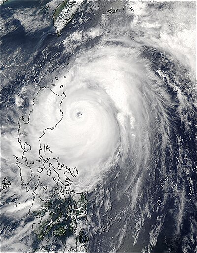
The meteorological history of Hurricane Ivan, the longest tracked tropical cyclone of the 2004 Atlantic hurricane season, lasted from late August through late September. The hurricane developed from a tropical wave that moved off the coast of Africa on August 31. Tracking westward due to a ridge, favorable conditions allowed it to develop into Tropical Depression Nine on September 2 in the deep tropical Atlantic Ocean. The cyclone gradually intensified until September 5, when it underwent rapid deepening and reached Category 4 status on the Saffir-Simpson Hurricane Scale; at the time Ivan was the southernmost major North Atlantic hurricane on record.
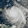
Ivan quickly weakened due to dry air, but it gradually reorganized, passing just south of Grenada as a major hurricane on September 7. The hurricane attained Category 5 status in the central Caribbean Sea. Over the subsequent days its intensity fluctuated largely due to eyewall replacement cycles, and Ivan passed just south of Jamaica, the Cayman Islands, and western Cuba with winds at or slightly below Category 5 status. Turning northward and encountering unfavorable conditions, Ivan gradually weakened before making landfall just west of Gulf Shores, Alabama on September 16 with winds of 120 mph (190 km/h). The cyclone quickly weakened to tropical depression status as it turned to the northeast, and Ivan transitioned into an extratropical cyclone on September 18. (Full article...)Selected image -
Selected season -

The 1988 Pacific hurricane season was the least active Pacific hurricane season since 1981. It officially began May 15, in the eastern Pacific, and June 1, in the central Pacific and lasted until November 30. These dates conventionally delimit the period of each year when most tropical cyclones form in the northeastern Pacific Ocean. The first named storm, Tropical Storm Aletta, formed on June 16, and the last-named storm, Tropical Storm Miriam, was previously named Hurricane Joan in the Atlantic Ocean before crossing Central America and re-emerging in the eastern Pacific; Miriam continued westward and dissipated on November 2.
The season produced 23 tropical depressions, of which 15 attained tropical storm status. Seven storms reached hurricane status, three of which became major hurricanes. The strongest storm of the season, Hurricane Hector, formed on July 30 to the south of Mexico and reached peak winds of 145 mph (233 km/h)—Category 4 status—before dissipating over open waters on August 9; Hector was never a threat to land. Tropical Storm Gilma was the only cyclone in the season to make landfall, crossing the Hawaiian Islands, although there were numerous near-misses. Gilma's Hawaiian landfall was unusual, but not unprecedented. There were also two systems that successfully crossed over from the Atlantic: the aforementioned Joan / Miriam and Hurricane Debby, which became Tropical Depression Seventeen-E, making the 1988 season the first on record in which more than one tropical cyclone has crossed between the Atlantic and Pacific basins intact. Three systems caused deaths: Tropical Storm Aletta caused one death in southwestern Mexico, Hurricane Uleki caused two drownings off the coast of Oahu as it passed by the Hawaiian Islands, and Hurricane Kristy caused 21 deaths in the Mexican states of Oaxaca and Chipas. (Full article...)Related portals
Currently active tropical cyclones

Italicized basins are unofficial.
- East and Central Pacific (2024)
- No active systems
- North Indian Ocean (2024)
- No active systems
- Mediterranean (2024–25)
- No active systems
- Australian region (2024–25)
- No active systems
- South Pacific (2024–25)
- No active systems
- South Atlantic (2024–25)
- No active systems
Last updated: 16:32, 15 August 2024 (UTC)
Tropical cyclone anniversaries

August 16,
- 1971 - Typhoon Rose reached its peak intensity with a central pressure of 952 hPa (mbar) in the South China Sea as it approached the Chinese coast. Rose severely affected Hong Kong and killed a total of 110 people.
- 2009 - Hurricane Erika (pictured) makes landfall over in northeastern Mexico at peak strength as a Category 1 hurricane. Two people died with only $10,000 in damages.

August 17,
- 1969 - Hurricane Camille made landfall on the Mississippian coastline near Waveland with 305 km/h (190 mph) winds, the second-strongest maximum sustained wind speed at landfall of any Atlantic hurricane to strike the contiguous United States. Camille killed over 250 people and caused $1.4 billion in damage.
- 2013 - Tropical Depression Maring (pictured) affects the Philippines by enhancing the southwest monsoon killing 27 people with ₱690 million (US$15.4 million) before intensifying into a tropical storm.

August 18,
- 1983 - Hurricane Alicia made landfall as a Category 3 hurricane near Galveston, Texas. Alicia killed 21 people and caused $2 billion worth of damage.
- 2008 - Tropical Storm Fay (pictured) makes landfall over in Florida where it reached peak intensity overland. Moreover 21 people have perished over in America.
Did you know…


- …that the Joint Typhoon Warning Center considers that Typhoon Vera (pictured) of 1986 is actually two distinct systems, formed from two separated low-level circulations?
- …that Cyclone Freddy (track pictured) in 2023 was the longest-lasting tropical cyclone worldwide?
- …that Cyclone Raquel (track pictured) travelled between the Australian and South Pacific basins between the 2014–15 and 2015–16 seasons, spanning both seasons in both basins?
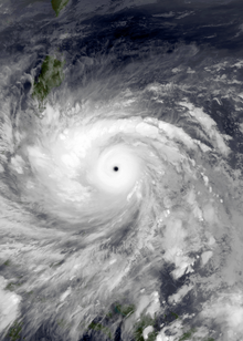
- …that Hurricane Otis (pictured) in 2023 was the first Pacific hurricane to make landfall at Category 5 intensity and surpassed Hurricane Patricia as the strongest landfalling Pacific hurricane on record?
General images -
Topics
Subcategories
Related WikiProjects
WikiProject Tropical cyclones is the central point of coordination for Wikipedia's coverage of tropical cyclones. Feel free to help!
WikiProject Weather is the main center point of coordination for Wikipedia's coverage of meteorology in general, and the parent project of WikiProject Tropical cyclones. Three other branches of WikiProject Weather in particular share significant overlaps with WikiProject Tropical cyclones:
- The Non-tropical storms task force coordinates most of Wikipedia's coverage on extratropical cyclones, which tropical cyclones often transition into near the end of their lifespan.
- The Floods task force takes on the scope of flooding events all over the world, with rainfall from tropical cyclones a significant factor in many of them.
- WikiProject Severe weather documents the effects of extreme weather such as tornadoes, which landfalling tropical cyclones can produce.
Things you can do
 |
Here are some tasks awaiting attention:
|
Wikimedia
The following Wikimedia Foundation sister projects provide more on this subject:
-
Commons
Free media repository -
Wikibooks
Free textbooks and manuals -
Wikidata
Free knowledge base -
Wikinews
Free-content news -
Wikiquote
Collection of quotations -
Wikisource
Free-content library -
Wikiversity
Free learning tools -
Wikivoyage
Free travel guide -
Wiktionary
Dictionary and thesaurus


