Portal:Tropical cyclones
The Tropical Cyclones Portal
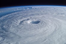
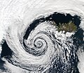
A tropical cyclone is a storm system characterized by a large low-pressure center, a closed low-level circulation and a spiral arrangement of numerous thunderstorms that produce strong winds and heavy rainfall. Tropical cyclones feed on the heat released when moist air rises, resulting in condensation of water vapor contained in the moist air. They are fueled by a different heat mechanism than other cyclonic windstorms such as Nor'easters, European windstorms and polar lows, leading to their classification as "warm core" storm systems. Most tropical cyclones originate in the doldrums, approximately ten degrees from the Equator.
The term "tropical" refers to both the geographic origin of these systems, which form almost exclusively in tropical regions of the globe, as well as to their formation in maritime tropical air masses. The term "cyclone" refers to such storms' cyclonic nature, with anticlockwise rotation in the Northern Hemisphere and clockwise rotation in the Southern Hemisphere. Depending on its location and intensity, a tropical cyclone may be referred to by names such as "hurricane", "typhoon", "tropical storm", "cyclonic storm", "tropical depression" or simply "cyclone".
Types of cyclone: 1. A "Typhoon" is a tropical cyclone located in the North-west Pacific Ocean which has the most cyclonic activity and storms occur year-round. 2. A "Hurricane" is also a tropical cyclone located at the North Atlantic Ocean or North-east Pacific Ocean which have an average storm activity and storms typically form between May 15 and November 30. 3. A "Cyclone" is a tropical cyclone that occurs in the South Pacific and Indian Oceans.
Selected named cyclone -
Hurricane Sandy (unofficially referred to as Superstorm Sandy) was an extremely large and devastating tropical cyclone which ravaged the Caribbean and the coastal Mid-Atlantic region of the United States in late October 2012. It was the largest Atlantic hurricane on record as measured by diameter, with tropical-storm-force winds spanning 1,150 miles (1,850 km). The storm inflicted nearly $70 billion USD in damage (equivalent to $93 billion in 2023), and killed 254 people in eight countries, from the Caribbean to Canada. The eighteenth named storm, tenth hurricane, and second major hurricane of the 2012 Atlantic hurricane season, Sandy was a Category 3 storm at its peak intensity when it made landfall in Cuba, though most of the damage it caused was after it became a Category 1-equivalent extratropical cyclone off the coast of the Northeastern United States.
Sandy developed from a tropical wave in the western Caribbean Sea on October 22, quickly strengthened, and was upgraded to Tropical Storm Sandy six hours later. Sandy moved slowly northward toward the Greater Antilles and gradually intensified. On October 24, Sandy became a hurricane, made landfall near Kingston, Jamaica, re-emerged a few hours later into the Caribbean Sea and strengthened into a Category 2 hurricane. On October 25, Sandy hit Cuba as a Category 3 hurricane, then weakened to a Category 1 hurricane. Early on October 26, Sandy moved through the Bahamas. On October 27, Sandy briefly weakened to a tropical storm and then strengthened back to a Category 1 hurricane. Early on October 29, Sandy curved west-northwest (the "left turn" or "left hook") and then moved ashore near Brigantine, New Jersey, just to the northeast of Atlantic City, as a post-tropical cyclone with hurricane-force winds. Sandy continued drifting inland for another few days while gradually weakening, until it was absorbed by another approaching extratropical storm on November 2. (Full article...)
Selected article -
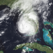
Hurricane Charley was the first of four separate hurricanes to impact or strike Florida during 2004, along with Frances, Ivan and Jeanne, as well as one of the strongest hurricanes ever to strike the United States. It was the third named storm, the second hurricane, and the second major hurricane of the 2004 Atlantic hurricane season. Charley lasted from August 9 to 15, and at its peak intensity it attained 150 mph (240 km/h) winds, making it a strong Category 4 hurricane on the Saffir–Simpson scale. It made landfall in Southwest Florida at maximum strength, making it the strongest hurricane to hit the United States since Hurricane Andrew struck Florida in 1992 and tied with Hurricane Ian as the strongest hurricane to hit southwest Florida in recorded history.
After moving slowly through the Caribbean, Charley crossed Cuba on Friday, August 13 as a Category 3 hurricane, causing heavy damage and four deaths. That same day, it crossed over the Dry Tortugas, just 22 hours after Tropical Storm Bonnie had struck northwestern Florida. It was the first time in history that two tropical cyclones struck the same state in a 24-hour period. At its peak intensity of 150 mph (240 km/h), Hurricane Charley struck the northern tip of Captiva Island and the southern tip of North Captiva Island, before crossing over Bokeelia causing severe damage. Charley then continued to produce severe damage as it made landfall on the peninsula in Punta Gorda. It continued to the north-northeast along the Peace River corridor, devastating Punta Gorda, Port Charlotte, Cleveland, Fort Ogden, Nocatee, Arcadia, Zolfo Springs, Sebring, Lake Placid, and Wauchula. Zolfo Springs was isolated for nearly two days as masses of large trees, power poles, power lines, transformers, and debris filled the streets. Wauchula sustained gusts to 147 mph (237 km/h); buildings in the downtown areas caved onto Main Street. (Full article...)
Selected image -

Selected season -

The 2018 Pacific hurricane season was one of the most active Pacific hurricane seasons on record, producing the highest accumulated cyclone energy value on record in the basin. The season had the fourth-highest number of named storms – 23, tied with 1982. The season also featured eight landfalls, six of which occurred in Mexico. The season officially began on May 15 in the Eastern Pacific, and on June 1 in the Central Pacific; they both ended on November 30. These dates conventionally delimit the period of each year when most tropical cyclones form in the Pacific basin. However, tropical cyclone formation is possible at any time of the year, as illustrated when the first tropical depression formed on May 10, five days prior to the official start of the season.
The second named storm of the season, Hurricane Bud, struck Baja California Sur in mid-June, causing minor damage. Tropical Storm Carlotta stalled offshore of the Mexican coastline, where it also caused minor damage. In early August, Hurricane Hector became one of the few tropical cyclones to cross into the Western Pacific from the Eastern Pacific, while also affecting Hawaii. Tropical Storm Ileana brought torrential rainfall to southwestern Mexico during early August, causing relatively minor damage. A few weeks later, Hurricane Lane obtained Category 5 intensity while also becoming Hawaii's wettest tropical cyclone on record and the second wettest tropical cyclone in United States history, only behind Hurricane Harvey of the previous year. Hurricane Olivia also struck Hawaii, resulting in relatively minor damage. (Full article...)
Related portals
Currently active tropical cyclones

Italicized basins are unofficial.
- East and Central Pacific (2024)
- No active systems
- West Pacific (2024)
- Typhoon Yinxing (Marce)
- Severe Tropical Storm Toraji (Nika)
- Tropical Storm Man-yi
- North Indian Ocean (2024)
- No active systems
- Mediterranean (2024–25)
- No active systems
- South-West Indian Ocean (2024–25)
- No active systems
- Australian region (2024–25)
- No active systems
- South Pacific (2024–25)
- No active systems
- South Atlantic (2024–25)
- No active systems
Last updated: 09:08, 10 November 2024 (UTC)
Tropical cyclone anniversaries

November 9
- 1995 - A cyclone (pictured) made landfall over Andhra Pradesh, causing widespread damage across much of the country, later spawning a rare snowstorm in Nepal. It killed 236 people along its path.

November 10
- 2001 - Typhoon Lingling (pictured) reached its peak intensity in the South China Sea with a central pressure of 940 hPa (mbar) to the east of Vietnam which it made landfall on soon afterwards. Lingling was responsible for about 200 deaths in Vietnam and the Philippines.
- 2015 - Cyclone Megh makes landfall over Yemen, and is regarded as one of the worst cyclones to strike Socotra. Megh killed 18 people and damaged about $1.9 billion.

November 11
- 1961 - Typhoon Karen struck Guam near peak intensity, damaging or destroying 95% of the buildings on the island, and killing 11 people.
- 2020 - Typhoon Vamco makes landfall over Luzon, Philippines as a weak typhoon. Vamco became the sixth costliest typhoon in the Philippines, with estimated damages of ₱20.3 billion (US$421 million).
Did you know…


- …that the Joint Typhoon Warning Center considers that Typhoon Vera (pictured) of 1986 is actually two distinct systems, formed from two separated low-level circulations?
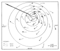
- …that Cyclone Freddy (track pictured) in 2023 was the longest-lasting tropical cyclone worldwide?
- …that Cyclone Raquel (track pictured) travelled between the Australian and South Pacific basins between the 2014–15 and 2015–16 seasons, spanning both seasons in both basins?
- …that Hurricane Otis (pictured) in 2023 was the first Pacific hurricane to make landfall at Category 5 intensity and surpassed Hurricane Patricia as the strongest landfalling Pacific hurricane on record?
General images -

Within the Pacific Ocean, the name of any significant tropical cyclone can be retired from the tropical cyclone naming lists by the World Meteorological Organization if it concludes that a storm was so deadly or damaging that any future use of that name would be inappropriate. Storm names can also be retired for other reasons, such as being deemed politically insensitive. Within the Eastern Pacific and Central Pacific basins (between 140°W and the western coast of North America and between the International Date Line (180°) and 140°W, respectively, and north of the Equator), a total of 21 names have been retired from the official lists. The deadliest system to have its name retired was Hurricane Pauline, which caused over 230 fatalities when it struck Mexico during October 1997, while the costliest hurricane was Hurricane Otis which caused an economic impact of over $12 billion in October 2023. Dora and Otis were the most recent Pacific tropical cyclones to have their names retired. (Full article...)
Topics
Subcategories
Related WikiProjects
WikiProject Tropical cyclones is the central point of coordination for Wikipedia's coverage of tropical cyclones. Feel free to help!
WikiProject Weather is the main center point of coordination for Wikipedia's coverage of meteorology in general, and the parent project of WikiProject Tropical cyclones. Three other branches of WikiProject Weather in particular share significant overlaps with WikiProject Tropical cyclones:
- The Non-tropical storms task force coordinates most of Wikipedia's coverage on extratropical cyclones, which tropical cyclones often transition into near the end of their lifespan.
- The Floods task force takes on the scope of flooding events all over the world, with rainfall from tropical cyclones a significant factor in many of them.
- WikiProject Severe weather documents the effects of extreme weather such as tornadoes, which landfalling tropical cyclones can produce.
Things you can do
 |
Here are some tasks awaiting attention:
|
Wikimedia
The following Wikimedia Foundation sister projects provide more on this subject:
-
Commons
Free media repository -
Wikibooks
Free textbooks and manuals -
Wikidata
Free knowledge base -
Wikinews
Free-content news -
Wikiquote
Collection of quotations -
Wikisource
Free-content library -
Wikiversity
Free learning tools -
Wikivoyage
Free travel guide -
Wiktionary
Dictionary and thesaurus


