
Regions of Turkmenistan
| Capital city district and Regions of Turkmenistan | |
|---|---|
| |
 | |
| Category | Unitary state |
| Location | Turkmenistan |
| Number | 5 Regions 1 Capital city district |
| Populations | (Regions only): 479,500 (Balkan) - 1,287,700 (Mary) |
| Areas | (Regions only): 139,000 km2 (53,800 sq mi) (Balkan) – 97,300 km2 (37,550 sq mi) (Ahal) |
| Government |
|
| Subdivisions | |
 |
|---|
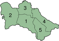
Turkmenistan is divided into five regions or welayatlar (singular welayat) and one capital city district (şäher).
| Division | ISO 3166-2 | Capital city | Area[1] | Pop (2001)[2] | Key |
|---|---|---|---|---|---|
| Aşgabat | TM-S | Ashgabat | 260 km2 (100 sq mi) | 730,000 | |
| Ahal Region | TM-A | Anau | 97,260 km2 (37,550 sq mi) | 785,800 | 1 |
| Balkan Region | TM-B | Balkanabat | 139,300 km2 (53,800 sq mi) | 479,500 | 2 |
| Daşoguz Region | TM-D | Daşoguz | 73,400 km2 (28,300 sq mi) | 1,196,700 | 3 |
| Lebap Region | TM-L | Türkmenabat | 93,700 km2 (36,200 sq mi) | 1,160,300 | 4 |
| Mary Region | TM-M | Mary | 87,200 km2 (33,700 sq mi) | 1,287,700 | 5 |
The heads of the regions (Template:Lang-tk, "the leader") are appointed by the President of Turkmenistan (Constitution of Turkmenistan, Articles 80-81).
See also
References
- ^ Passport of Turkmenistan 1998, National Institute of Statistics and Forecasting of Turkmenistan, Ashgabat, 1998 Template:Ru icon.
- ^ Social-economic situation of Turkmenistan in 2001, National Institute of State Statistics and Information of Turkmenistan, Ashgabat, 2002, pp. 68-69 Template:Ru icon.
This Turkmenistan location article is a stub. You can help Wikipedia by expanding it. |
Region (capital) | |
|