Shire of Murrindindi
| Shire of Murrindindi Victoria | |||||||||||||||
|---|---|---|---|---|---|---|---|---|---|---|---|---|---|---|---|
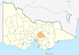
 Location in Victoria | |||||||||||||||
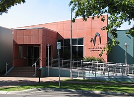
 Council Offices in Alexandra | |||||||||||||||
| Population | 13,693 (2015 est)[1] | ||||||||||||||
| • Density | 3.5210/km2 (9.1192/sq mi) | ||||||||||||||
| Established | 1994 | ||||||||||||||
| Gazetted | 18 November 1994[2] | ||||||||||||||
| Area | 3,889 km2 (1,501.6 sq mi) | ||||||||||||||
| Mayor | Cr Margaret Rae | ||||||||||||||
| Council seat | Alexandra | ||||||||||||||
| Region | Hume | ||||||||||||||
| State electorate(s) | Eildon | ||||||||||||||
| Federal division(s) | Indi | ||||||||||||||
 | |||||||||||||||
| Website | Shire of Murrindindi | ||||||||||||||
| |||||||||||||||

The Shire of Murrindindi is a local government area in the Hume region of Victoria, Australia, located in the north-east part of the state. It covers an area of 3,889 square kilometres (1,502 sq mi) and, at the 2011 Census, had a population of 13,058.[3] It includes the towns of Alexandra, Buxton, Eildon, Flowerdale, Kinglake, Marysville, Molesworth, Strath Creek, Taggerty, Yarck and Yea. It was formed in 1994 from the amalgamation of the Shire of Alexandra, Shire of Yea, and parts of the Shire of Broadford, Shire of Eltham, Shire of Euroa, Shire of Healesville and City of Whittlesea.[2]
The Shire is governed and administered by the Murrindindi Shire Council; its seat of local government and administrative centre is located at the council headquarters in Alexandra, it also has service centres located in Kinglake and Yea. The Shire is named after the locality of Murrindindi, which is located near the geographical centre of the LGA.
Parts of Murrindindi were badly affected by the 2009 Victorian bushfires, notably the towns of Marysville and Kinglake. 106 people lost their lives across the Shire that day, including 38 in Kinglake and 34 in Marysville.
Council
Current composition
The council is composed of five wards and five councillors, with one councillor per ward elected to represent each ward.[4]
| Ward | Councillor | Notes | |
|---|---|---|---|
| Cathedral | Christine Challen | ||
| Cheviot | John Kennedy | ||
| Eildon | Bernie Magner | ||
| King Parrot | Cris Ruhr | ||
| Kinglake | Andrew Derwent | ||
| Koriella | John Walsh | ||
| Red Gate | Margaret Rae | Mayor (2013–14) | |
Administration and governance
The council meets in the council chambers at the council headquarters in the Alexandra Municipal Offices, which is also the location of the council's administrative activities. It also provides customer services at both its administrative centre in Alexandra, and its service centres in Kinglake and Yea.
See also
References
- ^ "3218.0 – Regional Population Growth, Australia, 2014–15". Australian Bureau of Statistics. Retrieved 29 September 2016.
- ^ a b Victoria Government Gazette – Online Archive (1837–1997). "S87 of 1994". State Library of Victoria. State Government of Victoria (published 18 November 1994). p. 4. Retrieved 10 January 2014.
{{cite web}}:|article=ignored (help) - ^ Census QuickStats (2011). "Murrindindi (S) – LGA25620". Australian Bureau of Statistics. Government of Australia. Retrieved 10 January 2014.
- ^ Local Government in Victoria. "Murrindindi Shire Council". Department of Transport, Planning and Local Infrastructure. State Government of Victoria. Retrieved 10 January 2014.
External links
- Murrindindi Shire Council official website
- Camping in Murrindindi
- Metlink local public transport map
- Link to Land Victoria interactive maps
37°20′00″S 145°30′00″E / 37.33333°S 145.50000°E

