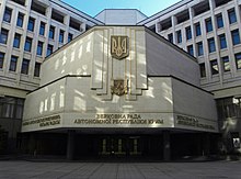
Verkhovna Rada of Crimea
| |
|---|---|
 | |
| Type | |
| Type | |
| History | |
| Founded | June 19, 1991 |
| Disbanded | March 15, 2014 |
| Preceded by | Crimean regional council |
| Succeeded by | State Council of Crimea |
| Leadership | |
First Deputy Chairman | Serhiy Donich[1] |
| Structure | |
| Seats | 100 |
 | |
Political groups |
|
| Elections | |
Last election | 2010 |
| Meeting place | |
 | |
| Building of the Supreme Council of Crimea, Simferopol | |
| Constitution | |
| Constitution of Crimea | |
Verhovna Rada of Crimea or the Supreme Council of Crimea, officially the Supreme Council of the Autonomous Republic of Crimea (Template:Lang-uk; Template:Lang-ru; Template:Lang-crh) was a Ukrainian legislative body of the Autonomous Republic of Crimea before the annexation of Crimea by the Russian Federation in 2014.
The last election of parliament took place on 31 October 2010 (see Crimean parliamentary election, 2010) and were won by the Party of Regions and the Communist Party of Ukraine.
On 27 February 2014 unidentified armed militants took over the parliament and hoisted a Russian flag over it. On 15 March 2014 the Verkhovna Rada of Ukraine officially dissolved the parliament. On 17 March 2014, one day before the Russian annexation of Crimea[2], the State Council of Crimea was established in place of the Verkhovna Rada of Crimea.
Last election
Template:Crimean parliamentary election, 2010
Template:Crimean Council changes after 2010 election
See also
References
- ^ Serhiy Donich. Dovidka.
- ^ "Ukraine 'preparing withdrawal of troops from Crimea'". BBC News. 19 March 2014. Retrieved 20 March 2014.

