
Riverside South, Manhattan
 A view of the complex from the Hudson River | |
| Other name(s) | Freedom Place and Riverside Center (for parts) |
|---|---|
| Location | Manhattan, New York City, New York |
| Coordinates | 40°46′41″N 73°59′20″W / 40.778°N 73.989°W |
| Status | All buildings complete; highway relocation begun, but incomplete. |
| Groundbreaking | 1997 |
| Constructed | 1997–2020 |
| Use | Residential |
| Website | ExtellDev |
| Companies | |
| Architect | Daniel Gutman and Paul Willen; Marilyn Taylor and David Childs, SOM |
| Developer | The Trump Organization, Hudson Waterfront Associates, Extell Development Company |
| Owner | Extell Development and The Carlyle Group |
| Planner | Riverside South Planning Corporation |
| Technical details | |
| Cost | US$3 billion |
| Buildings | 19 |
| Size | 8.4 million square feet (780,000 m2) |
| No. of residents | over 8,000 as of 2012 |
| Proposed | 1989 (current plan) 1961 (first plan) |
Riverside South is an urban development project in the Lincoln Square neighborhood of the Upper West Side of Manhattan, New York City, United States. Developed by the businessman Donald Trump in collaboration with six civic associations, the largely residential complex is on 57 acres (23 ha) of land along the Hudson River between 59th Street and 72nd Street. The $3 billion project, which replaced a New York Central Railroad yard known as the 60th Street Yard, includes multiple residential towers and a extension of Riverside Park.
There were several proposals for the site in the late 20th century. These included the Litho City plan in the 1960s, Trump's 1970s plan, and the Lincoln West plan of the early 1980s. The current proposal stems from Trump's late-1980s proposal for Television City. Television City was originally designed to include 16 apartment buildings, 1.8 million square feet (170,000 m2) of studio space, 300,000 square feet (30,000 m2) of office space, ancillary retail space, and a 75-acre (30 ha) waterfront park. Trump sold Riverside South to investors from Hong Kong and mainland China, which built seven structures starting in 1997. In 2005, the investors sold the remaining unfinished portions to the Carlyle Group and the Extell Development Company. which developed three more buildings. In turn, Extell sold off some of the southernmost plots in the 2010s; these sites became Waterline Square.
60th Street Rail Yard
[edit]Before Riverside South was developed, the site was a rail freight yard owned by the New York Central Railroad, located between 59th and 72nd streets.[1] By 1849 an embankment near West End Avenue, with a span over a tidal lagoon, carried the Hudson River Railroad, later part of New York Central. At the time, much of the current site of Riverside South was still under water.[2] By 1880, what had been river was transformed by landfill into the New York Central Railroad's vast 60th Street Yard.[2][3] Within the 60th Street Yard, a set of 400-foot-long (120 m) piers extended into the Hudson River, where barges carried railcars across the river to New Jersey.[4] The piers protruded at a 55-degree angle and each contained tracks.[5]
In the 1930s, New York City parks commissioner Robert Moses covered New York Central's rail track north of 72nd Street as part of the West Side Improvement, which also moved rail lines below grade south of 60th Street.[6][7]: 696–698 The Moses project was bigger than Hoover Dam and created the Henry Hudson Parkway. The adjacent Riverside Park was expanded to the Hudson River.[8]
Until the 1970s, the rail yard area was generally industrial.[2] The area was home to a printing plant for The New York Times between 1959 and 1975,[9] as well as ABC television studios. At the same time, public housing extended to West End Avenue (across the street from the printing plant and the TV studios), and the Lincoln Towers redevelopment project extended to the rail yard boundary along Freedom Place.[10] New York Central merged with the Pennsylvania Railroad to form Penn Central in 1968 as the rail lines were suffering severe financial difficulties.[11] The railroad went bankrupt in 1970,[12] and its assets were sold off in federal court.[13]

Early redevelopment plans
[edit]In the late 20th century, there had been several proposals to develop structures over the rail yard.[1][15] These included the Litho City plan in the 1960s; the businessman Donald Trump's 1970s plan; the Lincoln West plan of the early 1980s; and Trump's Television City plan of the late 1980s. In his book New York 2000, Robert A. M. Stern described the site as "one of the city's most coveted and contested parcels of open land".[1] The site was hard to develop in part because it did not have roads or utilities, and because any potential redevelopment would have had to be built over the train yard.[15]
1960s plans
[edit].jpg)
In 1961, the railroad proposed a partnership with the Amalgamated Lithographers Union to build Litho City, a mixed-use development over the tracks.[1][16] There would be six 47-story buildings and three 41-story buildings, all designed by Kelly & Gruzen. The development would have included 200 artists' studios that faced north; the rest of the units would be structured as rental apartments or housing cooperatives.[16] Sources variously cited Litho City as being built to accommodate 12,500[17] or 25,000 people.[16] The New York City Planning Commission (CPC) deferred action on the Litho City proposal for a year while it reviewed Litho City's effects on traffic in the neighborhood,[18] and the consulting firm of Day & Zimmerman warned that the development might worsen traffic.[19] Nonetheless, the union's president Edward Swayduck and the city's traffic commissioner Henry A. Barnes both endorsed the Litho City plan.[18]
The CPC designated the West Side rail yard as an urban renewal site in October 1962, allowing the plans for Litho City to proceed.[17][20] Shortly afterward, the Amalgamated Lithographers Union announced plans for a $15 million dormitory in the development, which would house 1,000 foreign students.[21] Plans also called for a promenade linking to Lincoln Center, in addition to a park on the Hudson River shoreline.[22] A scale model of Litho City was unveiled at Grand Central Terminal in 1963.[22] By then, the project was being planned as a high-income development, rather than a middle-income development; the cost of Litho City was estimated at $175 million.[23] There were to be 6,000 apartments,[24] and a new street, running parallel to the yard between 66th and 70th streets, was also proposed.[25] Moses also planned to build an exit from the West Side Highway to Litho City, prompting objections that the street grid could not handle the additional traffic.[26]
The plans for Litho City were formally dropped in January 1966 due to disputes over the air rights; the railroad had terminated the union's lease of the site two months prior.[27] In the late 1960s, there were various proposals by the city's Educational Construction Fund for mixed residential and school projects, also partly on landfill.[1][28] This development would have included several athletic fields and between 6,000 and 12,000 apartments.[1] In the early 1970s, Moses proposed relocating the highway between 59th and 72nd streets to ground level to facilitate an extension of Riverside Park, but he was unsuccessful.[29] The state rejected that proposal because of the presumed negative effect on development opportunities and because it would violate the Blumenthal Amendment, which prohibited any highway construction that would alter Riverside Park.[30][31]
First Trump proposal and sale
[edit]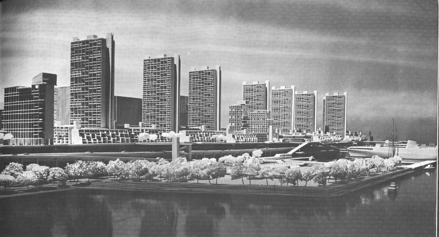
In July 1974, Trump Enterprises Inc., a company controlled by Trump, offered to buy an option on the 100-acre (40 ha) 60th Street Yard and the 44-acre (18 ha) 30th Street Yard for a combined $100 million.[32] Trump did not make a down payment.[33][13] Penn Central, which at the time was under trusteeship due to its insolvency, petitioned its trustees to approve the sale.[32] Though both of the yards were still being used by freight trains,[32] the only structures on the sites were storage buildings and train tracks.[34] Following a private meeting with Trump, his father Fred, and Mayor Abraham Beame, Penn Central's trustees gave the option to Trump because he "seemed best positioned [...] to get rezoning and government financing".[13] A U.S. federal court approved Penn Central's sale of the option to Trump in March 1975.[34]
Initially, Trump wanted to build up to 20,000[35][36] or 30,000[13] housing units on the site.[13][35] At the time, he had never completed a major real-estate development before.[37] Local politicians including U.S. Representative Bella Abzug expressed concerns about the fact that the 60th Street redevelopment would cater mostly to middle- and upper-class families.[36] Trump presented plans for the development to local residents in April 1976. As part of the proposal, designed by Gruzen & Partners, the site would be divided into three sectors with at least four buildings each; about 40 percent of the development would be open space, and there would be one or two schools and a central shopping mall.[38] There would have been 14,500 apartments on the site, funded with federal subsidies.[38][39] Manhattan Community Board 7, representing the neighborhood that included the rail yard, opposed the plan.[35][38] Trump twice downsized his plans for the yards.[35] By May 1976, Trump's plans called for the West Side Highway to be relocated so he could build a park next to it;[40] the Department of City Planning endorsed this plan.[41] The state ultimately proposed reconstructing the highway viaduct instead.[42]
Another proposal, for 12,450 apartments, was dependent on public financing that never materialized.[43] In May 1979, Trump exercised his option on the site, agreeing to buy the yard for $28 million.[44] Had Trump finalized the acquisition, he would have been required to make payments over 18–30 months, after which he could take title to the site.[45] However, Trump never finalized his purchase, and his father's longtime friend Abe Hirschfeld agreed to take over the option instead.[46] By then, the city government was contemplating building a freight yard for piggyback trains on the site.[47][48] Penn Central signed a sale contract in March 1980, agreeing to sell Hirschfeld and his son Elie the site for $28 million.[49] Under the terms of the contract, the Hirschfelds made a $400,000 down payment and were required to spend $700,000 on planning over the next year.[47] Trump later said that his decision to let his option expire was "the toughest business decision in my life".[50]
Lincoln West
[edit]Abe Hirschfeld and the Argentine astrophysicist Carlos Varsavsky acquired the 60th Street Yard site in late 1980.[51][52] Varsavsky's company, the Macri Group, became the project's majority partner, with a 65% ownership stake; the Hirschfelds held the remaining 35% stake.[47][51][15]
Initial plan
[edit].jpg)
Hirschfeld and Varsavsky formed a partnership named Lincoln West Associates to develop a project known as Lincoln West on the 60th Street Yard site.[53] Macri hired Gruzen & Partners to draw up plans for the project, and he hired former deputy mayor John Eugene Zuccotti and lawyer Judah Gribetz to consult on the project.[47] Rafael Viñoly assisted Gruzen with the plans.[54] The initial plans, announced in January 1981, called for 16 residential towers with a total of 4,850 apartments,[53][55] arranged around a new avenue called Lincoln Boulevard.[54] There would also be a 500-room hotel,[55] one or two office towers, and 42 acres (17 ha) of open space.[53] A 4,000-space parking garage would have been located underneath the development.[56] Due to the topography of the site, the buildings at both the northern and southern ends would have been located on a platform, and Lincoln Boulevard would have been built with two levels.[54] The first apartments would have begun construction in 1982, while the rest of the development would have been built in phases over a decade.[55][56]
Lincoln West Associates submitted a formal proposal for the site in November 1981.[15] When the plans were announced, The New York Times' architecture critic Paul Goldberger wrote that "much can be improved in the design of Lincoln West" but predicted that the development itself would alleviate the high demand for luxury housing in the city.[57] In late 1981, Lincoln West Associates offered to give $10,000 to Community Board 7 for a study of the project's impacts.[58] The plans had to undergo community review.[59] Opponents claimed that the development would overload the area's infrastructure,[56][60] and other critics took issue with the development's size[56][61] and the lack of affordable housing.[56][57] The firm of McKeown & Franz conducted an environmental impact statement (EIS) for the site.[50] The EIS found that the project would create 7,000 jobs, but that it would also overload existing transit infrastructure due to the presence of 9,200 additional commuters.[62] Community Board 7 refused to support the project unless it was downscaled to include fewer than 4,000 residential units.[63] Ultimately, Hirschfeld and Varsavsky agreed to pay for infrastructure improvements in the neighborhood.[57][64]
Macri sent the plans to the CPC for review in March 1982 but, despite the concerns over Lincoln West's size, initially refused to scale down the plans.[65] The same month, the city asked Lincoln West Associates to postpone its plans so the city could decide whether to build a new freight terminal there,[66][67] and Lincoln West Associates agreed to restart the community review process.[59] Additionally, part of the parking garage was replaced with space for trucking company, and the number of apartments was reduced to 4,700.[54] Manhattan borough president Andrew Stein wanted the project to be further reduced to 3,700 apartments, which Varsavsky refused.[60][68] The engineering firm Tippetts Abbett McCarthy Stratton conducted a feasibility study of the proposed freight-rail center, finding that it was feasible to build it under Lincoln West,[69] though Varsavsky opposed the freight center.[70][71]
Approval, lawsuits, and modifications
[edit]The CPC approved the Lincoln West plans in July 1982,[70][72] disregarding most of the opponents' objections to the project, although it asked the developers to reduce the project's size.[73] The New York City Board of Estimate also gave its approval that September.[74][75][76] The plans called for 1,100 rental apartments (of which one-fifth would be affordable housing), in addition to 3,200 luxury co-ops or condos.[64] In addition, the developers agreed to add several amenities such as a swimming pool, a park, and upgrades to two nearby subway stops.[77] Lincoln West Associates paid $13 million for the northern five blocks shortly after the plans were approved, and it paid $21.6 million that December for the southern eight blocks.[78] The developers had planned to begin construction in April 1983,[76] but the plans were delayed after Varsavsky's sudden death in early 1983.[79] Francisco Macri took over Varsavsky's 65% interest in the project.[15]
Delays also arose from various lawsuits.[79] Opponents sued in the New York Supreme Court in February 1983, alleging that the EIS had been done improperly.[80] The EIS was invalidated the next month,[81] though the city government successfully appealed the ruling.[82] The New York Court of Appeals, the state's highest court, ruled in October 1983 that the EIS had been prepared properly.[83] In addition, Harry Helmsley, who owned an option on a superblock from 61st to 65th streets, sued the city and Lincoln West Associates, claiming that the city wanted to build three streets through his property.[84]
Though work had still not begun by early 1984, Lincoln West's developers were already revising the plans significantly, prompting its chairman to resign.[85] Additionally, in July 1984, Chase Manhattan Bank moved to foreclose on two mortgages that had been placed on the site.[86] The city government would have canceled the development if the street grid had not received final approval by that September,[87] but the Board of Estimate voted to extend the deadline by one month.[88] That October, the Board of Estimate approved plans for Lincoln West's street grid and voted to give Lincoln West Associates four additional months to obtain financing.[89] By then, public officials doubted that Lincoln West would ever be completed, amid continued opposition to the project.[90] Lincoln West Associates ultimately could not receive financing for the development, partly because of Macri's concessions to the city and partly because Trump was trying to retake control of the site.[91]
Television City
[edit]Trump negotiated to repurchase Lincoln West in mid-1984; he initially decided against it[90] but ultimately made an offer for the site that November.[92] Trump announced in December 1984 that he would pay $95 million for the Lincoln West site;[93] this was part of a $115 million transaction that gave Trump control of the rail yard.[35] Under the agreement, Trump controlled 80% of the project, Elie Hirschfeld retained a 20% stake, and Francisco Macri gave up his interest in the project.[93] Trump initially anticipated constructing towers as tall as 60 stories, rather than a variety of low-rise buildings, as Lincoln West Associates had been proposed.[94] He hired the Chicago–based architect Helmut Jahn in January 1985 to design the as-yet-unnamed development on the site.[95] Trump, who called the Lincoln West tract "one of the best pieces of real estate in the country", contemplated erecting up to 8,000 apartments there.[96] He also wanted to build a supertall skyscraper, following two unsuccessful approvals to build such a tower at the New York Coliseum site and on Wall Street.[97]
Initial plan
[edit]
In November 1985, Trump announced plans for the Television City complex, which would feature a television studio headquarters.[98][99][100] The plan involved 7,900 apartments, along with retail, office, and television studio space.[99] A 150-story supertall tower would rise from the middle of the complex,[98][99] near 66th Street.[101] The skyscraper would have included 750 hotel rooms and 60 floors of residences,[102] and it would have been 1,670 feet (510 m) tall, making it the world's tallest building.[98] Several other towers, each 72[103] or 76 stories high, would flank the 150-story tower,[35][62][101] and there would be 3.6 million square feet (330,000 m2) of television studio space.[98][100][101] In addition, the development would have 8,500 parking spaces,[104] 40 acres (160,000 m2) of parkland, and 1.7 million square feet (160,000 m2) of retail space.[62][105] Shortly after the plans were announced, Trump and the media company NBC discussed the possibility of relocating NBC's headquarters from Rockefeller Center to Television City.[105][106][107] Trump met with other television networks as well, including ABC and CBS.[100][108] The urban planner Norman Levin, who had formerly worked for Gruzen, was in charge of 20 separate teams who were working on the project.[109]
Crain's New York called Trump's plan "the most ambitious development project ever in New York".[109] Goldberger wrote that Television City was "woefully simplistic" and that the towers' designs had only a tenuous relationship with the street grid.[110] New York Magazine's architecture critic Carter Wiseman agreed, writing "isolated towers", such as those proposed in Television City, "survive in most of the world's major cities as reminders to planners that this brand of angst-inducing exclusivity is nasty to live with".[111] Wiseman also said the development would cause overcrowding at the 72nd Street/Broadway station of the New York City Subway.[111] A writer for the New York Daily News described the buildings as "intimidating and psychologically disturbing, dwarfing everything that's human in scale".[112]
The proposal needed both a new EIS and a public review,[62][101] and Trump hired McKeown & Franz to conduct the EIS.[50] As such, construction could not start until 1987; Trump predicted that it would take five years to complete.[113] The project soon received large amounts of opposition.[114] Local residents expressed skepticism to the project,[113][115] citing its size and the fact that it targeted the upper middle class.[116] The Coalition Against Lincoln West called Television City "doubly excessive", dubbing it as even more extreme than the Lincoln West plan,[106] while other opponents were specifically against the 150-story tower.[108] Opponents ranged from small associations to the Westpride group,[50] the latter of which enlisted notable neighborhood residents and raised hundreds of thousands of dollars to fund the effort.[35][117] Trump was initially reluctant to acquiesce to opponents' demands, fearing that doing so would endanger the development.[118] Trump tentatively agreed to sell Kumagai Gumi a 25% ownership stake in the development in 1986, but the agreement was rescinded due to disagreements over how much Kumagai Gumi was to pay.[119][120]
Changes in plans
[edit]Even though Trump liked the original plans,[116] he ultimately decided to replace Jahn as Television City's master planner.[35][121] Jahn remained the architect for the proposed supertall tower.[122] In June 1986, he appointed Alexander Cooper as the site's new master planner;[121] Newsday described Cooper as having a "sensitivity to scale" that contrasted with Trump's bold style.[123] Trump and Cooper announced revised plans for Television City in October 1986.[124][125] Cooper reduced the 150-story tower to 136 stories;[104][125][126] according to Cooper, the supertall tower would include less floor area than the Sears Tower or either of the World Trade Center's twin towers.[102] The modified project still contained roughly the same amount of space, including 1.5 million square feet (140,000 m2) each of studio and retail space as well as 7,600 housing units. The six 72-story towers were replaced with slightly smaller, 45- to 57-story skyscrapers, which line one side of an avenue that would run north-south through most of the development.[125][126] The plan included fewer parking spaces and more parkland as well.[104]
Cooper's version of Television City still received criticism.[104][103][124] Peter Marcuse of Columbia University expressed doubts that the 150-story tower was economically feasible, and Kenneth Frampton, also of Columbia, described the building as "a violent irrelevancy".[102] By contrast, Goldberger described Cooper's design for the site as "vastly more sophisticated" than Jahn's plan,[127] and he wrote that Trump's decision to hire Cooper may have been part of Trump's efforts to ingratiate himself with the local community.[116]
By early 1987, Trump was negotiating to lease the entirety of the supertall skyscraper's office space to General Electric (GE), which at the time owned NBC.[128] Trump offered to sell the site to the New York State Urban Development Corporation and lease it back for 99 years.[129][130] In exchange, Trump would have received a 20-year[131][132] or 30-year tax abatement for Television City,[129] which would have been the highest-valued abatement ever granted in New York City.[131] Trump also offered to give the city government a portion of Television City's profits.[133][134] Despite widespread public support for Trump's tax abatement,[132] the city rejected Trump's proposal,[133][134] and Mayor Ed Koch offered the tax breaks directly to NBC instead of to Trump.[35][133] Negotiations between Trump and Koch devolved into name-calling;[135] Trump called on Koch to resign, and Koch compared Trump to "a stuck pig".[119][136] The plans called for 11 residential buildings, about 2 million square feet (190,000 m2) of office space, several parks, and a 152-story tower by mid-1987.[137] The department store chain Bloomingdale's negotiated to lease space in Television City as well.[138]
The project continued to face major opposition;[114] for example, Westpride raised over $20,000 at a late-1987 fundraiser opposing Television City.[139] Trump indicated that September that he wanted to sell NBC part of the Television City parcel for $20 million,[140] and he also tried to entice financial services firms to move there.[141] The Trump Organization also conducted a new EIS to appease opponents' concerns about Television City.[142] The new EIS, published in October 1987, found that the development would cast shadows on the neighborhood, overload local transportation infrastructure, and interfere with television broadcasts.[143] A local group known as the Parks Council commissioned a scale model of Television City, showing the shadows that the development would create.[114][144]
Renaming and further revisions
[edit]At the end of October 1987, NBC decided against moving to Television City,[119][145][146] even as Trump Organization officials claimed that the EIS was close to being approved.[118] Politico reporter Michael Kruse wrote that the CPC likely would never have approved Trump City,[35] though David W. Dunlap of The New York Times wrote that much of the project might have indeed been approved.[147] Afterward, Trump initially planned to replace the television studio with a park or movie theater, even while preserving other aspects of the plans.[146] In February 1988, Trump announced a revised plan for the project, which was renamed Trump City. The TV studio space was replaced with parkland, two small office buildings were added, and 760 of the apartments were designated as affordable housing for the elderly.[148] The 150-story tower was retained, and there were to be 13 smaller towers.[149] Goldberger wrote that Trump had added the affordable housing units to increase the likelihood of getting community approval,[150] a sentiment shared by the project's opponents.[151] By October 1988, there was speculation that Trump might sell the site.[152] Despite receiving five offers, all for hundreds of millions of dollars,[153] Trump ultimately decided to keep the site.[154][155]
Westpride, which had 4,200 members at the end of 1988, continued to fight Trump City,[155][156] and local civic groups promised to sue the city government if Trump City were approved.[157] Community Board 7 and the Municipal Art Society jointly sponsored a study that recommended extending Riverside Park and the Manhattan street grid through the site.[158] To increase the development's floor area by 4.5 million square feet (420,000 m2),[159] Trump suggested transferring air rights from a 19-acre (7.7 ha) tract under the Hudson River to the rest of Trump City.[147][149][160] Further delays arose in 1989 when the city government investigated complaints that the Trump Organization was relocating possibly-contaminated dirt from Trump City to Fresh Kills Landfill.[160] Trump alleged that Koch's administration was delaying the review of the project's EIS.[161] In early 1990, Trump submitted a draft EIS to the New York City Council,[162] which called for the structures to be built in several phases.[37] Trump had spent nearly $200 million to date, even though construction had not started.[37] Chase Manhattan Bank, which had given Trump a mortgage loan on the site, expressed concerns that the loan could not be repaid,[163] and Trump was paying tens of millions of dollars a year just to maintain the site.[114][37]
Local civic groups filed a lawsuit in June 1990 to prevent the city government from rezoning the 60th Street Yard for the Trump City development.[164] The project was still opposed by groups such as the American Institute of Architects,[165] and local politicians called on the city government to buy the site from Trump.[166] Goldberger wrote that Trump City had turned into "a national symbol both of massive, overreaching development and of diehard community opposition to it".[167] In response, Trump hired an advertiser to promote the development to residents in the New York metropolitan area.[168] By that August, Trump had submitted three scaled-down plans for the site to the CPC.[169] In November 1990, a New York Supreme Court judge invalidated zoning permits that the CPC had granted to Trump City,[170] although the proposal was still undergoing public review as late as February 1991.[171]
Manhattan West and ABC proposals
[edit]In 1985, the developer Daniel Brodsky acquired the land just east of the yard between 61st and 64th streets.[172] He proposed a development known as Manhattan West, which initially called for 1,375 apartments,[173] and he also wanted NBC to relocate to the site.[174] By 1987, his plans called for 1,200 affordable and luxury apartments across more than 1 million square feet (93,000 m2), in addition to 2.5 acres (1.0 ha) of parkland.[173][175] The apartments would have been located in an L-shaped building with several roofs measuring up to 39 stories high, as well as 28-story building to the south.[175] The CPC forced Manhattan West to conform to Television City's site plan, which included a block-wide park between 63rd and 64th streets extending east to West End Avenue.[126][176] A new version of the plan, with 1,000 apartments and only 600,000 square feet (56,000 m2), was proposed in 1989.[175] The Board of Estimate approved the revision in February 1990,[172] and work on Manhattan West began in 1994.[177][178]
Meanwhile, Brodsky had sold off the northernmost 2 acres (0.81 ha) of the Manhattan West site to Capital Cities/ABC in 1986.[179] By the 1990s, Capital Cities/ABC was planning to erect three 39-story residential buildings and several television studios.[180][181] The residential buildings, with a combined 930 units, would have been located from 64th to 65th streets, while the studios would have been located to the north.[179] Capital Cities/ABC's proposal was submitted for public review in 1992,[179] but Community Board 7 rejected the original plans.[182][183] Capital Cities/ABC then canceled one of the towers and downsized the project to 500 apartments.[182]
Riverside South
[edit]Civic organization proposal
[edit]Initial plan
[edit]
At the end of 1989, six civic organizations—the Municipal Art Society, Natural Resources Defense Council, New Yorkers for Parks, Regional Plan Association, Riverside Park Fund, and Westpride—proposed an alternative plan for the site,[184] devised by the engineer Daniel Gutman and the architect Paul Willen.[167][103] The plans called for residential project of 7.3 million square feet (680,000 m2).[167][185][186] The West Side Highway would be relocated underground to make room for a 23-acre (9.3 ha) expansion of Riverside Park,[186][187][188] and a new Riverside Boulevard would run above the relocated highway.[189] Trump was negotiating with these civic groups by the beginning of 1991,[190] and he formally abandoned plans for Trump City in March 1991.[185][188][191] The project was to have 8.3 million square feet (770,000 m2) of space in total.[191][192][193] These plans called for 5,500 apartments[188][192] and up to 1.8 million square feet (170,000 m2) for television studios.[188][191] In addition, four artists were hired to design the complex's public spaces.[191] Goldberger referred to Trump's abandonment of the Trump City plans as a "miracle".[194]
Trump and the civic groups formed the Riverside South Planning Corporation (RSPC) to develop the project, which they called Riverside South.[35][114][195] Chase Manhattan Bank, which still held more than $200 million in mortgages on the site, initially paid all of RSPC's expenses.[196] In April 1991, the RSPC hired David Childs of SOM, along with Paul Willen, to oversee Riverside South's design.[195][197] A group of planners and architects, appointed by Manhattan borough president Ruth Messinger, recommended that the plans be downsized even further.[198] The RSPC unveiled a scale model of its proposal in August 1991, which called for several curved towers of up to 50 stories high.[199] By early 1992, RSPC chairman Richard Kahan said the tallest residential buildings would be 40 stories and be clustered at either end of the site.[180] There were to be 16 residential towers and two office towers.[200] Both the city and state governments of New York endorsed the project, even though Trump had not pledged funds to improve nearby subway stations, as local residents had requested.[196] Trump also did not want to add affordable housing units, saying it would be unprofitable to do so.[193]
Approval process and objections
[edit]
In May 1992, the CPC granted the Riverside South project a certification, allowing the public review process to commence.[196][201] However, the project faced opposition because of its size, traffic issues, lack of affordable housing, and its association with Trump.[202] Some residents of Lincoln Towers, which adjoined the rail yard, opposed any development on the site.[186] Minor objections included the fact that the towers might block the west–facing windows of the Chatsworth apartment building on 72nd Street.[203][204] Residents of 71st Street, a dead end street, objected to the fact that their street would be extended to Riverside Boulevard.[205] A report commissioned for Community Board 7 found that Riverside South would overwhelm the neighborhood's transit infrastructure unless it was reduced to 4,300 apartments,[206] and the community board voted in July 1992 to recommend that the project not proceed.[207] Additionally, Messinger said she would not support the plans without further alterations.[114][208]
Following these objections, Trump agreed to slightly reduce the project's size, remove the office space, provide funds for the 72nd Street subway station, reserve 12% of the apartments for affordable housing, and build and maintain the new public park.[114][209] The RSPC agreed to extend 71st Street for pedestrians while preventing through vehicular traffic,[205] and setbacks were mandated on each of the buildings.[210] Messinger agreed to support the project after Trump acquiesced to the subway improvements, park, and affordable-housing units,[211][212] but other critics still strongly opposed the project.[213] U.S. Representative Jerry Nadler described the planned public park as a $10-million-per-acre ($25,000,000/ha) "private backyard for the people who live in these buildings".[214] Amid the opposition, Trump denied that he planned to sell the site.[212] To convince the CPC to approve his plans, Trump agreed to provide even more money for the 72nd Street subway station and designate 20% of the apartments as affordable housing.[215][210] Trump also agreed to extend Riverside Drive southward to alleviate congestion on West End Avenue.[216] The CPC approved the Riverside South plan in October 1992.[217] A New York City Council subcommittee approved the plan that November after Trump agreed to delay the television studios' development,[189][218] and the full City Council approved Riverside South the next month.[219]
The final project size was 6.1 million square feet (570,000 m2)—with an option for 1.8 million square feet (170,000 m2) of television studios on the two southern blocks—as well as a park and improvements to the existing Freedom Place.[220] Goldberger wrote that the final plan "stands a real chance of being a cause for celebration rather than embarrassment."[199] The media estimated that Riverside South. Manhattan West, and the Capital Cities/ABC project would collectively house between 15,000 and 20,000 residents.[181][221] There was to be a 1-acre (0.40 ha) park at the confluence of the three developments.[221] The first phase of Riverside South called for four 18-to-40-story towers between 65th and 69th streets, with about 1,600 apartments.[222][223] Ultimately, the development was planned to include 16 buildings with 5,700 apartments, in addition to a 23-acre (9.3 ha) park and 1.8 million square feet of retail.[216][224]
By March 1993, Trump was applying for tax abatements and funding from the New York state government;[225] at the time, he owed the city $4.4 million in back taxes.[226] Philip Johnson was hired as one of the development's architects that November.[227] After the Riverside South plan was approved, Trump and proponents of Riverside South wanted the federal government to provide $80 million for the West Side Highway's relocation,[114] but this funding was delayed for several years.[214][228] Other opponents were upset by the decision to close the West Side Highway's northbound entrance and exit ramps at 72nd Street and fought to deny the highway project any funding.[229]
Partnership with Asian investors
[edit]
Meanwhile, during the mid-1990s, Chase Manhattan was pressuring Trump to repay the loan on the site,[230] and Trump wanted to refinance the project to pay the debt.[231] Colony Capital offered to buy the debt on Riverside South's loan in late 1993,[232][230] but these negotiations were unsuccessful.[233] Additional attempts at obtaining funding from American financiers were also unsuccessful,[230] and Trump said in early 1994 that he would apply for a loan from the United States Department of Housing and Urban Development.[234] He subsequently went to Hong Kong to negotiate with the businessman Henry Cheng.[235] The project was also involved in two lawsuits during this time,[230][236] one of which claimed that the project did not conform to Lincoln West's EIS.[114][237] The other lawsuit centered around sewage disposal;[114] at the time, Trump estimated that the development would generate 5 million U.S. gallons (19,000,000 L) of sewage a day, but he had not received permission to connect the development's sewage lines to the North River Wastewater Treatment Plant.[238]
Trump sold a controlling interest in the project in June 1994,[239][240][241] and a group of four developers from Hong Kong and mainland China, including New World Organization and Polylinks International, bought the controlling stake.[236] Polylinks paid Chase $90 million to settle the project's debt, plus $20 million in back taxes and other fees.[240] The group also committed to spending $2.5 billion on the project itself.[242] Cheng became Riverside South's primary financier and developer,[236][243] while Trump remained Riverside South's chief promoter.[241][244] Trump retained a 30% ownership stake in Riverside South,[245] which could be increased if he sold or rented a certain number of apartments.[246] The project was jointly developed by the Trump Organization and Hudson Waterfront Associates, the latter of which represented the Asian investors;[236] they hired feng shui consultants to provide advice on Riverside South's design.[247]
Though Riverside South's financial issues had been resolved, the lawsuits over the development were still pending.[230][236] Construction was delayed as the lawsuits were resolved and the economy recovered.[248] In February 1995, the city government resolved one of the legal disputes by allowing Trump to connect Riverside South's sewage line to the North River plant.[249] That June, the New York Court of Appeals ruled that the EIS for Riverside South had been conducted properly.[250] There was another controversy over the RSPC's plans to build a temporary playground between 70th and 72nd streets.[251] In the meantime, the new investors sought public financing.[114][252] Trump applied for a $355 million mortgage for Riverside South from the federal government;[253][254] if the mortgage were approved, up to 20% of the apartments would have been reserved for low-income or middle-income residents.[223] Trump was accused of paying off New York State Senate majority leader Joseph Bruno for approval,[254][255] and the project's opponents accused Trump of colluding with Mayor Rudy Giuliani on the mortgage application.[253] Nadler asked the Federal Housing Administration not to give a mortgage to Riverside South.[256]
Start of construction
[edit]First structures
[edit]
Trump and New World Organization hired Lehrer McGovern Bovis as Riverside South's construction manager in April 1995;[257] the firm went on to build eight of Riverside South's towers.[258] Work was delayed for two more years.[259][260] In December 1996, the New York City Department of Environmental Protection granted Trump permission to connect the development's first structure to the treatment plant,[259] and Trump received private financing for that building.[260] After the city granted a construction permit in January 1997,[261] a shanty town nearby was removed the next month.[262] Trump also indicated that, due to opposition to the West Side Highway's relocation, he would postpone Riverside Park South's construction.[263][264] By mid-1997, Lehrer McGovern Bovis and HRH Construction were erecting the first two towers at 180 and 200 Riverside Boulevard,[265] which had a combined 990 apartments.[266] One hundred and four units at 180 Riverside were set aside for low-income households.[267] Trump was also negotiating to install a massive statue of the explorer Christopher Columbus at Riverside South.[268] Residents of Lincoln Towers continued to oppose the project, saying it would block their views of the Hudson River.[269] Another group of opponents sued to force Trump to construct Riverside Park South.[264]
During the construction of 200 Riverside Boulevard, a subcontractor used substandard concrete to construct columns supporting the fifth floor, ignoring warnings from the building's structural engineer.[270] The New York City Department of Buildings (DOB) halted construction of the tower that November, after that tower had reached its 20th floor.[271] In addition, the first seven towers were exempt from the city's new seismic code due to a grandfather clause,[272] and two of the towers were also exempt from sprinkler regulations because they were shorter than 300 feet (91 m).[273] Work on 200 Riverside Boulevard resumed in January 1998 after the defective concrete was replaced.[274] By the middle of the year, the TV network CBS was negotiating to occupy studio space in Riverside South,[275] and New World was attempting to sell Riverside South's first two buildings.[276] The developers also rented out apartments at 180 Riverside Boulevard,[277] while Pace Advertising Agency was hired to market the apartments.[278] CBS ultimately decided against moving to Riverside South.[279]
By early 1999, several retailers were negotiating to move into the first two buildings,[280] and many of the condos and rental apartments were being leased out.[281][282] The first structures were initially branded as Trump Place.[283] New World and Trump placed a 9-acre (3.6 ha) tract between 59th and 61st streets for sale that May,[284] but they were unable to find a buyer.[285] In addition, work had commenced on a third building: a 33-story tower at 160 Riverside Boulevard.[286] Other developments, such as Tishman Speyer's 101 West End Avenue rental building, were also being built nearby.[287] The M72 bus was rerouted to serve the complex, prompting complaints from neighborhood residents.[288][289]
Early 2000s expansion
[edit]
By early 2000, work was about to begin on a fourth Trump Place building, a condo tower.[290] Later that year, Columbia University began negotiating to construct a satellite campus at the southern end of Trump Place,[291] although the university ultimately decided to develop buildings in Manhattanville instead.[292] Simultaneously, Trump developed a waterfront public park known as Riverside Park South.[293] Trump was required to expand the park as additional buildings were erected,[293][294] and he also had to preserve the 69th Street Transfer Bridge.[293][295] During the park's construction, complaints of sewage smells prompted the Trump Organization to replace 180 Riverside's pipes.[296] The park's first phase, which cost $14 million, unofficially opened in January 2001[5][297] and was dedicated that April.[298] Trump Place's real estate brokers, the Corcoran Group, reported higher-than-anticipated interest in the apartments, despite the development's relatively remote location.[299] Despite a slight downturn caused by the September 11 attacks later the same year, the apartments remained in high demand.[300] Also in 2001, Community Board 7 approved the addition of another park on Riverside Boulevard,[301] and the Federal Highway Administration approved the West Side Highway's relocation eastward.[302][303]
Although Trump ceased his active involvement in the development in 2001, he retained his 30% limited partnership.[304] The first retailer at Trump Place, a wine shop, opened in 2002,[305] four years after Trump had begun looking for retail tenants.[306] Trump planned to begin constructing the complex's sixth structure, 240 Riverside Boulevard, the same year,[307][308] which would have required the closure of the West Side Highway's 72nd Street exit ramp.[216] Work on 240 Riverside was delayed by opposition from residents of the neighboring Chatsworth Apartments, who feared the building would obstruct their windows,[289][307] as well as objections from local residents who wanted the 72nd Street exit ramp to remain open.[216][308] Despite the opposition, 240 Riverside was under construction by 2003.[216][309] A second segment of Riverside Park South opened that June,[310] and local residents attempted to preserve two burned piers within the park.[311] The city government agreed in early 2004 to close the 72nd Street exit ramp;[289][312] a state judge placed an injunction preventing the ramp's closure,[313] but an appeals court upheld the plans.[314] By the end of 2004, a seventh building at 120 Riverside Boulevard was being completed.[315] Due to legal disputes, the 72nd Street exit ramp remained open for three more years.[316]
Site resale and completion
[edit]Carlyle and Extell takeover
[edit]Trump and his partners sold Riverside South, excluding the finished condominiums, to the Carlyle Group and the Extell Development Company for $1.76 billion in June 2005.[317][318] The syndicate had beat out several other bidders including the Related Companies, Vornado Realty Trust, and the Durst Organization.[245] Carlyle obtained a 50% ownership stake in the project, while Extell took a 25% stake and sold the remaining 25% to an Irish development consortium.[319] Shortly afterward, Carlyle and Extell resold three rental apartment buildings to Equity Residential for $816 million.[320][321] Trump, who contended that the sale price was just over half what the property was worth, sued his partners,[33][322] but he lost.[323] The Corcoran Group also sued Trump, claiming that he had failed to pay sales commissions for apartments sold there.[324] Carlyle and Extell also attempted to sell the land between 59th and 61st streets[317] before withdrawing their plans in December 2005.[320] The seventh structure, 120 Riverside Boulevard, opened in early 2006,[325] and the developers began erecting the northbound West Side Highway tunnel between 62nd and 65th streets that year.[303][326] The third phase of Riverside Park South opened that August,[327] and the development's first supermarket also opened in 2006.[306]
In the mid-2000s, Extell developed the Avery condominium building at 100 Riverside Boulevard,[328] as well as the Rushmore nearby at 80 Riverside Boulevard.[329] The West Side Highway's 72nd Street exit finally closed in June 2007,[316] though the connection from Riverside Boulevard to Riverside Drive did not open for another four years.[330] A fourth section of Riverside Park South opened in 2008.[331] Thomas Balsley subsequently designed three more sections of the park.[332] In addition, Extell began developing the Aldyn condominium and a rental tower between 62nd and 63rd streets in early 2008,[333] and it received a $613 million loan to develop the towers.[334] The Avery was finished in 2008, followed by the Rushmore in 2009[335] and the Aldyn in 2010.[336] Amid weakening demand for condos at the Aldyn, Avery, and Rushmore, several prospective condo buyers sought to cancel their purchases.[337] Multiple would-be buyers at the Rushmore sued Carlyle and Extell in 2009 after the developers refused to refund their apartment deposits;[338] they received a $15 million refund after three years of litigation.[339] Extell filed plans for 40 Riverside Boulevard (later One Riverside Park), just north of Riverside Center, in 2009,[340] and Hill West Architects was hired to design a 33-story building on that site.[340][341]
Riverside Center and Waterline Square
[edit]
The southernmost section of Riverside South, which had been set aside for television studios, needed to be rezoned before residential structures could be built there.[342][343] In October 2008, Extell proposed constructing Riverside Center, a set of five mostly residential towers between 59th and 61st streets, to complete the development.[344] Originally, Christian de Portzamparc was hired to design the buildings.[344][345] Riverside Center, covering 3.1 million square feet (290,000 m2), was modeled on the design of Battery Park City,[346] with 2,500 residential units, retail, a cinema, a K-5 school, a hotel, and open space.[347] The first site, known as site 2, would have contained 616 apartments and a school.[348] Local residents quickly organized in opposition to the plans; among other things, they objected to the presence of 1,800 parking spaces and an automobile dealership.[349] In mid-2010, Community Board 7 voted to recommend that the city government disapprove the plans for Riverside Center,[350] and Manhattan borough president Scott Stringer also refused to accept the plans.[351] In response, two lawyers and three lobbyists from Extell began negotiating with the city government.[352] Extell agreed to add a school and affordable housing,[353] cancel plans for a department store,[352] and improve parks in the area.[354]
The City Council approved Riverside Center's towers in December 2010[343][355] following a protracted dispute over the zoning.[335] Extell hired Dattner Architects to design Riverside Center's school in 2011,[356] Community Board 7 approved plans for the first Riverside Center building, occupying site 2, in August 2012.[357] The Carlyle Group subsequently solicited bids for the development of the Riverside Center sites, inviting Extell to submit a bid.[342] Dermot Realty Management Company won the bid to develop site 2,[342] and the company bought the site in December 2012 for $70 million.[358] Dermot also hired SLCE Architects to design the building at site 2, replacing de Portzamparc as the architect there.[342][345] Silverstein Properties and El-Ad Group paid $160 million in 2013 for One West End Avenue, one of the five sites in the Riverside Center project.[359] Silverstein and El-Ad's site became the One West End condominium building, while Dermot's site became the 21 West End Avenue rental building.[360]
In 2014, Extell announced plans for the remaining three sites in Riverside Center.[361] Extell never developed the remaining Riverside Center sites. General Investment and Development Companies (GID) bought the site at 400 West 61st Street in May 2015,[362] and GID bought additional land at 20 Riverside Boulevard that November.[347] GID bought the remaining tract at Riverside Center in December 2015.[347][363] The project became Waterline Square, which was completed in 2020;[364] the Waterline Square project includes three towers with 1,132 total units.[365] Richard Meier & Partners, Kohn Pedersen Fox, and Rafael Viñoly designed the three Waterline Square towers.[366]
2010s to present
[edit]The Collegiate School agreed to move to Riverside South in 2013[367] and announced plans for a 10-story campus building at 301 Freedom Place South the next year.[368] Extell began selling units at One Riverside Park in late 2013,[369] and it subsequently opened a housing lottery for that building's affordable apartments.[370] Silverstein and El Ad began selling the condos at One West End in 2015,[371] and they also launched an affordable-housing lottery for that building.[372] Dermot also began renting out units at 21 West End Avenue in 2016.[373]
The first seven Riverside South buildings were originally known as Trump Place,[374] and six of these buildings (excluding 240 Riverside Boulevard) contained large signs with that name on their facades.[375] After Trump won the 2016 United States presidential election, the residents of 140, 160, and 180 Riverside Boulevard voted to remove the Trump Place signage from their respective structures.[376] Many of these residents had been politically opposed to Trump and had signed petitions in favor of the removal of the Trump name.[377] The Trump signage was removed from 200 Riverside Boulevard in October 2018 after that building's residents also voted to remove the signs.[378] The Trump signage was also removed from the facade of 120 Riverside Boulevard in 2019;[379] this was followed shortly afterward by the removal of Trump signage on 220 Riverside Boulevard, the final building in the complex that still bore the Trump Place name.[375][380]
Riverside Park South's fifth phase opened in 2020.[381] A&E Real Estate bought 140 Riverside Boulevard in 2022 for $266 million,[382] and that firm paid another $415 million for 160 Riverside Boulevard the same year.[383]
Buildings
[edit]
Overall, the development consists of 19 apartment buildings, condominiums, and lease properties.[384] As of 2012[update], the buildings housed a combined 8,000 people; the area was collectively called "Riverside Boulevard" after its main street, or "The Strip" after its long, narrow shape. Six more towers with a combined 3,000 units, as well as a school, a hotel, retail and restaurant space, and space for a movie theater, had yet to be completed. A 3.4-acre (1.4 ha) park between the buildings was in the planning stages.[384] The towers were constructed as green buildings.[385] Each structure's facade has a setback no higher than 125 to 150 feet (38 to 46 m) from the street; this was intended to reduce the buildings' visual impact.[281]
Most living units in Riverside South are high-end housing, costing at least $2,000 per square foot (22,000/m2).[384] Per-foot real estate prices for Riverside South housing rose 66% from 2004 to 2014, compared with a 43% increase in real estate on the Upper West Side overall.[360] For instance, baseball player Alex Rodriguez bought a 39th-floor Rushmore condominium for $5.5 million in March 2011, then sold it for $8 million in January 2012.[384] At the same time, 12% to 20% of the units are designated as affordable, as required by the CPC approval of the project.[386] Some buildings in the development, such as One Riverside Park, were controversial having separate entrances for affordable-housing residents,[387][388] despite the legality of such "poor doors" in mixed-housing buildings.[389]
Notable structures
[edit]| Address / Name | Completion date | Height (ft/m) | Stories | Apartments | Notes/references |
|---|---|---|---|---|---|
| 40 Riverside Boulevard / One Riverside Park | 2015 | 375 feet (114 m) | 33 | 219 | [390] |
| 60 Riverside Boulevard / The Aldyn | 2011 | 395 feet (120 m) | 38 | 136 | [391] |
| 80 Riverside Boulevard / The Rushmore | 2008 | 425 feet (130 m) | 41 | 271 | [392] |
| 100 Riverside Boulevard / The Avery | 2008 | 344 feet (105 m) | 30 | 274 | [328][393] |
| 120 Riverside Boulevard | 2004 | 230 feet (70 m) | 18 | 275 | [394] |
| 140 Riverside Boulevard | 2003 | 338 feet (103 m) | 26 | 354 | [382][395] |
| 160 Riverside Boulevard | 2001 | 354 feet (108 m) | 33 | 459 | [286][396] |
| 180 Riverside Boulevard | 1999 | 422 feet (129 m) | 40 | 516 | [280][397] |
| 200 Riverside Boulevard | 2000 | 492 feet (150 m) | 46 | 377 | [280][398] |
| 220 Riverside Boulevard | 2003 | 542 feet (165 m) | 49 | 430 | [399][398] |
| 240 Riverside Boulevard / The Heritage | 2004 | 362 feet (110 m) | 31 | 170 | [224][400] |
| 1 Waterline Square | 2019 | 429 feet (131 m) | 36 | 272 | [365][401] |
| 2 Waterline Square | 2019 | 397 feet (121 m) | 38 | 646 | [365][402] |
| 3 Waterline Square | 2019 | 391 feet (119 m) | 34 | 244 | [365][403] |
| 400 West 63rd Street / The Ashley | 2010 | — | 23 | 209 | [404] |
| 1 West End Avenue / Riverside Center Building 5 | 2017 | 513 feet (156 m) | 43 | 246 | [405] |
| 21 West End Avenue / Riverside Center Building 2 | 2016 | 529 feet (161 m) | 45 | 616 | [406] |
| 75 West End Avenue / West End Towers | 1995 | 404 feet (123 m) | 39 | 1,000 | [407] |
| 101 West End Avenue / Archstone | 2000 | 370 feet (113 m) | 33 | 503 | [408] |
Trump and Hudson Waterfront Associates built the first seven buildings at Riverside South.[335][384] Three additional buildings were completed by Extell: the Avery, the Rushmore, and the Aldyn.[335][409] To attract families, Extell added various amenities to these three buildings, including playrooms, a bowling alley, a basketball court, and other sports facilities.[410] The southern end of the development includes the 362-unit One West End condominium building,[360] which includes amenities such as a cantilevered swimming pool.[360][411] Next to One West End is a 616-unit rental building at 21 West End Avenue,[360] which has a fitness center and basement pool.[360]
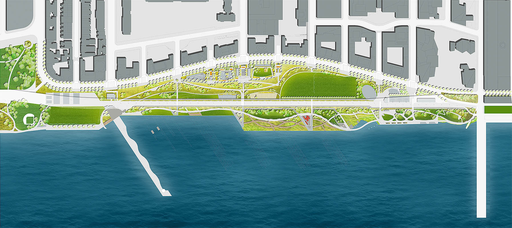
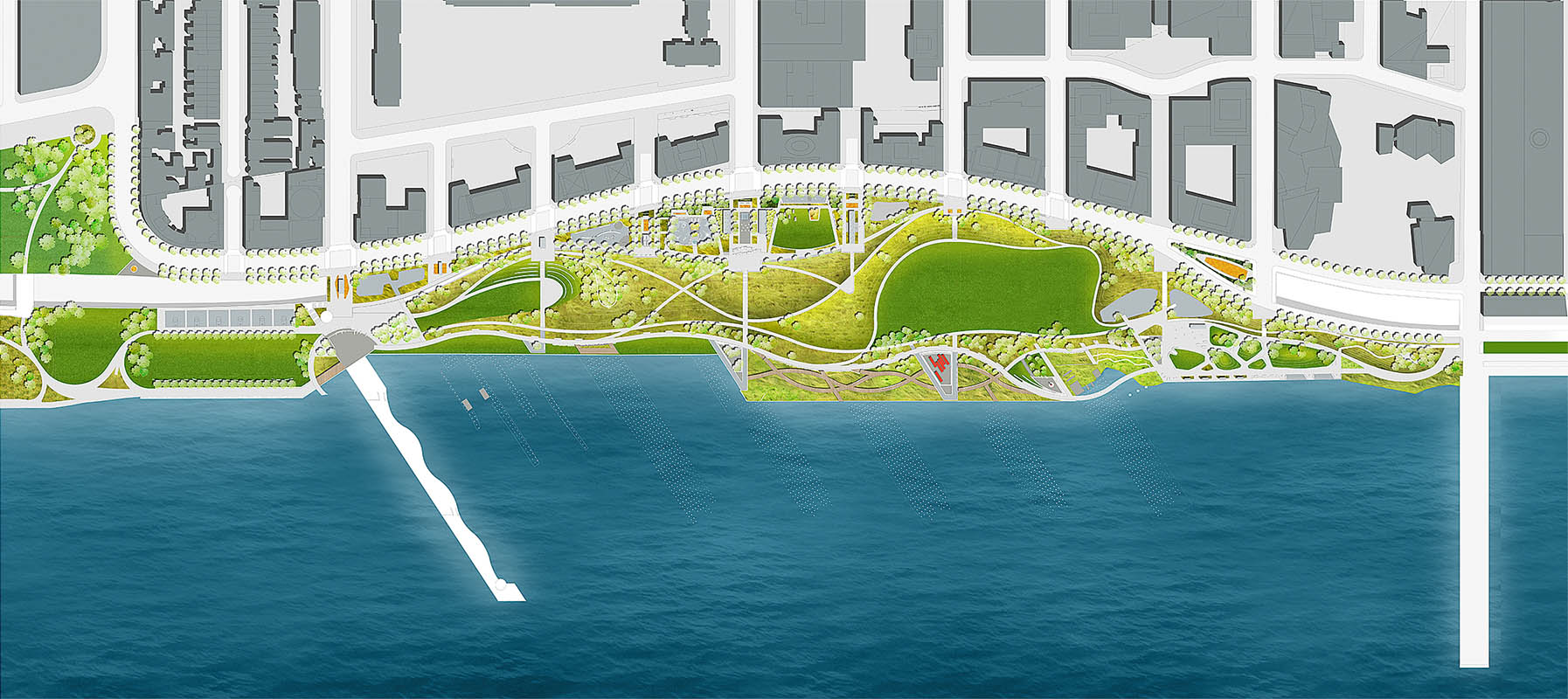
Parks
[edit]Riverside Park South
[edit]
The 25-acre (10 ha) Riverside Park South is an extension of Riverside Park[167] and is funded by fees paid by Riverside South's residents.[412] Phase 1, a 7-acre (2.8 ha) section from 72nd to 68th Streets, was opened in April 2001.[298] Pier I at 70th Street, part of the railyard, was rebuilt; it maintains its original length of 795 feet (242 m), but is narrower than originally, at 55 feet (17 m).[413] Phase 2 comprises a waterfront section from 70th Street to 65th Street and opened in June 2003.[310] It has two plazas at 66th and 68th Streets, as well as a jagged waterfront.[414] Phase 3, opened in August 2006,[327] stretches from 65th to 62nd streets on the waterfront. [414] Phase 4 opened in 2008 along the waterfront, extending from 63rd to 59th streets (overlapping with phase 3).[331] A new mixed-use bikeway and walkway was also built through the park, linking Hudson River Park with Riverside Park.[415]
The design of phases 5 and 6, located east of the elevated highway viaduct, was partly tied to the fate of the highway relocation.[303] Relocating the highway will require some reconstruction of the park.[416] A fifth phase of Riverside Park South opened in October 2020, encompassing the land east of the West Side Highway from 65th to 68th streets.[381] The city plans to expand the park with new baseball and soccer fields, bikeways, lawns, picnic areas, and restrooms.[417]

The park contains site-specific sculptures, railway ruins, gardens, a waterfront promenade, and a walkway.[418] Portions of the former rail yard were incorporated into the new park.[414][415] These include the New York Central Railroad 69th Street Transfer Bridge,[14][419] which is listed on the National Register of Historic Places.[420] As a reminder of the location's history, New York Central Railroad logos are engraved onto park benches.[415] A wooden pier named Pier D was originally preserved as part of the park,[421] but it was demolished in 2011 due to extreme deterioration.[422]
Other parks
[edit]On West End Avenue, a privately owned park has a remnant of a stone wall, as a remaining part of the embankment that dated to 1847. Construction workers had unearthed the stones during construction in 1994; some stones were salvaged for the new park during the four-day construction hiatus for archaeological excavation.[2] There is also a private 3-acre (1.2 ha) park at One West End.[423]
Other structures
[edit]Manhattan Community Board 7 members blamed Trump for failing to build the proposed enhancement and monument at Freedom Place, though the Riverside South Planning Corporation said that the Freedom Place plan was merely a concept for an arts program that was not included in the final project.[220] A street called Freedom Place South, along the same axis as Freedom Place, runs southward from 64th to 59th streets.[424] In addition, there is an unused tunnel underneath a portion of Riverside Boulevard between 62nd and 65th streets, which was intended to carry traffic from the West Side Highway.[303] The tunnel measures approximately 0.8 miles (1.3 km) long and 40 feet (12 m) wide.[326] Early plans called for the construction of a Metro-North Railroad station on the West Side Line at Riverside South as part of the Penn Station Access project; however, the station was canceled in 2010 because there was not enough space between the foundations of Riverside South's buildings.[425]
The IRT Powerhouse, located just south of Riverside South, was designed by Stanford White for the Interborough Rapid Transit Company[426] and is a New York City designated landmark.[427] Adjacent to the Powerhouse is a tetrahedron-shaped building known as VIA 57 West,[428] which was designed by Bjarke Ingels Group.[429] In addition, the Abraham Joshua Heschel School is located on West End Avenue next to Riverside South.[430]
References
[edit]Citations
[edit]- ^ a b c d e f Stern, Fishman & Tilove 2006, p. 824.
- ^ a b c d Dunlap, David W. (August 26, 2015). "Park's Stone Wall Is a Vestige of Manhattan's Rail History". The New York Times. ISSN 0362-4331. Archived from the original on October 9, 2016. Retrieved January 31, 2024.
- ^ City Planning Commission, "Riverside South Final Environmental Impact Statement (FEIS)," October 11, 1992, pp. II-H-3, II-H-18
- ^ Schneider, Daniel B. (July 6, 1997). "F.Y.I." The New York Times. Retrieved October 23, 2024.
- ^ a b Dunlap, David W. (January 18, 2001). "Design Notebook; Skyline Views From Midstream". The New York Times. Retrieved October 28, 2024.
- ^ Robbins, L.H. (June 3, 1934). "Transforming the West Side: A Huge Project Marches On". The New York Times. Archived from the original on August 23, 2019. Retrieved March 31, 2021.
- ^ Stern, Gilmartin & Mellins 1987, pp. 696–698.
- ^ Stern, Gilmartin & Mellins 1987, pp. 698–700.
- ^ "Times Begins Printing At New West Side Plant". The New York Times. July 29, 1959. Archived from the original on October 9, 2016. Retrieved May 17, 2016.
- ^ "Litho City Master Plan (aerial view)" (PDF). chpcny.org. Archived (PDF) from the original on June 10, 2016. Retrieved May 11, 2016.
- ^ Daughen, J.R.; Binzen, P. (1999). The Wreck of the Penn Central. Beard Books. p. 4. ISBN 978-1-893122-08-6. Archived from the original on March 8, 2024. Retrieved March 8, 2024.
- ^ "$200 Million Rescue Attempt Fails". The Vancouver Sun. TPS. June 22, 1970. p. 22.
- ^ a b c d e Barrett, Wayne (January 22, 1979). "Behind the Seventies-Era Deals That Made Donald Trump". Village Voice. Archived from the original on July 2, 2018. Retrieved July 1, 2018.
- ^ a b "Transfer Bridge, Riverside Park". Forgotten New York. August 19, 2015. Retrieved May 17, 2016.
- ^ a b c d e Lipman, Joanne (September 26, 1984). "Delayed New York Housing Project Shows Problems of Urban Ventures". The Wall Street Journal. p. 1. ISSN 0099-9660. ProQuest 397944656.
- ^ a b c "West Side Housing to Straddle Central Tracks". The New York Times. August 18, 1961. Retrieved October 9, 2024.
- ^ a b "Board Boosts Idea of a City Over the Rails". Daily News. October 18, 1962. p. 361. Retrieved October 10, 2024.
- ^ a b Ingraham, Joseph C. (October 8, 1962). "City Planners Set to Approve Site for Litho City Development; Project Housing 12,500 Will Dominate Hudson Shore From 60th to 70th Mayor and Aides Back Plan". The New York Times. Retrieved October 9, 2024.
- ^ "Warn Center Over Traffic". Daily News. September 30, 1962. p. 8. Retrieved October 10, 2024.
- ^ Madden, Richard L. (October 18, 1962). "Litho City Area Ruled Suitable for Renewal". New York Herald Tribune. p. 15. ISSN 1941-0646. ProQuest 1336051630; Bennett, Charles G. (October 18, 1962). "Litho City's Site is Approved Here; Planners Rule Area West of Lincoln Center Suitable for Urban Renewal". The New York Times. Retrieved October 9, 2024.
- ^ "Foreign Student Residence Included in Litho City Plan". New York Herald Tribune. October 20, 1962. p. 5. ISSN 1941-0646. ProQuest 1325679240; "Housing for Students Planned As Part of Litho City Project". The New York Times. October 20, 1962. Retrieved October 9, 2024.
- ^ a b "Model of $200 Million Litho City Goes on Display". The New York Times. November 21, 1963. Retrieved October 9, 2024.
- ^ Huxtable, Ada Louise (June 21, 1963). "Litho City: Hit or Flop?; Union Housing Plan Meets Snag in Bid for 'Greatness' Star Architect Sought Above Middle Income Architects Recommended Financing a Mystery". The New York Times. Retrieved October 10, 2024.
- ^ Fowler, Glenn (February 28, 1965). "Lincoln Sq. Area is Still Building". The New York Times. p. R1. ISSN 0362-4331. ProQuest 116767640.
- ^ Ingraham, Joseph C. (February 14, 1964). "One-Way Routing at Lincoln Center Is to Be Reversed". The New York Times. Retrieved October 10, 2024.
- ^ Kessler, Gerald; Schlegel, Harry (September 10, 1965). "Moses Has 3 Bees in His Various Bonnets". Daily News. pp. 3. 25. Retrieved October 10, 2024.
- ^ O'Kane, Lawrence (January 21, 1966). "Litho City Plans Dropped by Union; Railroad Held Obstructive on Air Rights Proposal". The New York Times. Retrieved October 9, 2024.
- ^ New York City Department of City Planning, "Lincoln Square and its Waterfront," NYC DCP 76-27, October 1976.
- ^ "Robert Moses' Proposal, 1974". Archived from the original on October 4, 2020. Retrieved May 19, 2020.
- ^ New York State DOT and FHWA, "West Side Highway Project: Section 6 of the Final Environmental Impact Statement," Archived October 6, 2024, at the Wayback Machine, pp. 7, 8, 1975, 1977
- ^ Prial, Frank J. (March 30, 1973). "West Side Studies 6 Highway Plans" (PDF). The New York Times. Archived from the original (PDF) on February 28, 2017.
- ^ a b c "Penn Central Trustees Petition To Sell Property: Court Asked to Clear Sale Of New York City Land For Over $100 Million". The Wall Street Journal. July 30, 1974. p. 2. ISSN 0099-9660. ProQuest 133918824; Fried, Joseph P. (July 30, 1974). "2 West Side Rail Yards Are Sought for Housing". The New York Times. Retrieved October 10, 2024.
- ^ a b Bagli, Charles V. (June 1, 2005). "Trump Group Selling West Side Parcel for $1.8 Billion". The New York Times. Archived from the original on June 16, 2016. Retrieved May 17, 2016.
- ^ a b "Penn Central Agrees to Sell 2 Inactive Yards: Trump Enterprises to Pay Minimum of $62 Million, Plus Option for Stake". The Wall Street Journal. March 11, 1975. p. 2. ISSN 0099-9660. ProQuest 133967449; McFadden, Robert D. (March 11, 1975). "Penn Central Yards' Sale Is Approved by U.S. Court". The New York Times. Retrieved October 10, 2024.
- ^ a b c d e f g h i j k Kruse, Michael (June 29, 2018). "The Lost City of Trump". POLITICO Magazine. Archived from the original on March 8, 2021. Retrieved July 1, 2018.
- ^ a b Fried, Joseph P. (March 12, 1975). "West Side Leaders Skeptical Of Plan to Develop Rail Yards". The New York Times. Retrieved October 10, 2024.
- ^ a b c d Demick, Barbara (May 27, 1990). "Trump City, or Trump's Folly?: a New York Neighborhood Has Organized to Fight Donald Trump's Most Ambitious Vision Yet". Philadelphia Inquirer. p. C.1. ProQuest 1834878796.
- ^ a b c Swertlow, Eleanor (April 30, 1976). "Says W. Siders Oppose a 'Co-op City on Hudson'". Daily News. p. 7. Retrieved October 10, 2024.
- ^ Klemesrud, Judy (November 1, 1976). "Donald Trump, Real Estate Promoter, Builds Image as He Buys Buildings". The New York Times. Retrieved October 10, 2024.
- ^ Horsley, Carter B. (May 9, 1976). "Park Extension Sought by Trump". The New York Times. Archived from the original on October 10, 2016. Retrieved March 31, 2021.
- ^ Fowler, Glenn (November 30, 1976). "A River Park West of Lincoln Sq. Endorsed by City Planning Study". The New York Times. Archived from the original on March 31, 2021. Retrieved March 31, 2021.
- ^ New York State DOT and FHWA, "West Side Highway Project: Final Environmental Impact Statement," June 4, 1977, p. 32.
- ^ Vitullo-Martin, Julia (January 19, 2004). "The West Side Rethinks Donald Trump's Riverside South". Manhattan Institute. Archived from the original on February 16, 2004. Retrieved May 17, 2016.
- ^ "Penn Central Corp. Posts Operating Profit For the First Quarter". The Wall Street Journal. May 7, 1979. p. 23. ISSN 0099-9660. ProQuest 134383064; Moritz, Owen (May 5, 1979). "West Side railyard is Trump's for 28M". Daily News. p. 45. Retrieved October 10, 2024.
- ^ "Penn Central Corp. Posts Operating Profit For the First Quarter". The Wall Street Journal. May 7, 1979. p. 23. ISSN 0099-9660. ProQuest 134383064.
- ^ Barrett, Wayne (1992). Trump: The Deals and the Downfall. HarperCollins Publishers. pp. 114–115. ISBN 0060167041.
- ^ a b c d Smith, Randy (November 1, 1980). "Latin maps $1B W. Side Complex". Daily News. pp. 196. 200. Retrieved October 10, 2024.
- ^ "New York's Plan for the Future; Total Cost at Least $180 Million New Link Instead of Zigzag Yard for Manhattan Industries". The New York Times. July 8, 1980. Retrieved October 10, 2024.
- ^ "Penn Central to Sell Manhattan Rail Yard For Total $28 Million". The Wall Street Journal. March 24, 1980. p. 21. ISSN 0099-9660. ProQuest 134434956; "Penn Central Sells Manhattan Site". The New York Times. March 22, 1980. Retrieved October 10, 2024.
- ^ a b c d Bernstein, Nina (March 25, 1987). "Trump He Plays for Keeps; It's Dream vs. Nightmare for Some Barren West Side Land". Newsday. p. 9. ISSN 2574-5298. ProQuest 285541417.
- ^ a b Blair, William G. (November 2, 1980). "Argentines Back New Effort To Build on Old Penn Rail Yards; Argentines Back New Effort to Develop Penn Yards". The New York Times. Retrieved October 10, 2024.
- ^ Postal, Bernard (November 30, 1980). "Postal Card". The New York Jewish Week. p. 35. ProQuest 371505226.
- ^ a b c Daniels, Lee A. (January 28, 1981). "Metropolitan Desk". The New York Times. Retrieved October 10, 2024.
- ^ a b c d Oser, Alan S. (August 8, 1982). "Perspectives: Lincoln West; Betting a Billion Dollars on the Upper West Side". The New York Times. Retrieved October 10, 2024.
- ^ a b c "It's toot-toot time for rail yard plan". Daily News. February 1, 1981. p. 285. Retrieved October 10, 2024.
- ^ a b c d e Chadwick, Bruce (January 6, 1982). "Dr. Varsavsky's incredible city". Daily News. pp. 96, 98. Retrieved October 10, 2024.
- ^ a b c Goldberger, Paul (August 29, 1982). "Architecture View; is the Lincoln West Project Right for the City?". The New York Times. Retrieved October 10, 2024.
- ^ Chadwick, Bruce (October 8, 1981). "Community board eyes private money for study". Daily News. p. 153. Retrieved October 10, 2024.
- ^ a b Purnick, Joyce (March 28, 1982). "West Side Waterfront Project is Facing a Series of Obstacles". The New York Times. Retrieved October 10, 2024.
- ^ a b "Lincoln West Plan Before City Board". Newsday. September 17, 1982. p. 31. Retrieved October 10, 2024.
- ^ "Hearing on West Side Project Draws Backers, Opponents". Newsday. August 20, 1982. p. 25. Retrieved October 10, 2024.
- ^ a b c d Gottlieb, Martin (November 20, 1985). "Trump's Plan for 150-story Tower on West Side Faces a Strenuous Review". The New York Times. Retrieved October 11, 2024.
- ^ Chadwick, Bruce (February 26, 1982). "Board asks scaling down of Lincoln West". Daily News. p. 97. Retrieved October 11, 2024.
- ^ a b Moritz, Owen (September 19, 1982). "1B Lincoln West: a real blockbuster". Daily News. p. 20. Retrieved October 10, 2024.
- ^ Chadwick, Bruce (March 23, 1982). "Unchanged Lincoln West plan goes before planning body". Daily News. p. 100. Retrieved October 10, 2024.
- ^ Purnick, Joyce (March 24, 1982). "City Asks Lincoln West to Defer Current Plans". The New York Times. Retrieved October 10, 2024.
- ^ Chadwick, Bruce (March 31, 1982). "More modest proposal for W. 60th". Daily News. p. 110. Retrieved October 10, 2024.
- ^ Lake, Katharine (September 15, 1982). "On eve of vote, Stein says no to Lincoln West". Daily News. p. 103. Retrieved October 10, 2024.
- ^ Chadwick, Bruce (June 17, 1982). "Rail-Freight Center Study is Completed". Daily News. p. 131. Retrieved October 10, 2024.
- ^ a b Burggraf, Helen (August 13, 1982). "Plan For Housing Complex Riles Sa: Lincoln West : The Freight Debate". Women's Wear Daily. Vol. 144, no. 31. pp. 1, 6–7. ProQuest 1445541521.
- ^ Chadwick, Bruce (July 19, 1982). "Lincoln West planner flatly bars freight center". Daily News. p. 62. Retrieved October 11, 2024.
- ^ Purnick, Joyce (July 20, 1982). "Luxury Housing Given Approval by City Planners". The New York Times. Retrieved October 10, 2024; Toscano, John; Chadwick, Bruce (July 20, 1982). "For Lincoln West, a major victory". Daily News. pp. 68, 73. Retrieved October 10, 2024.
- ^ Fitzgerald, Owen; La Rosa, Paul (August 19, 1982). "For Lincoln West, today's the big day". Daily News. p. 130. Retrieved October 11, 2024.
- ^ Barrett 1992, p. 298.
- ^ Lake, Katharine (September 18, 1982). "Mull suit to best Lincoln West". Daily News. p. 81. Retrieved October 10, 2024.
- ^ a b Purnick, Joyce (September 17, 1982). "Estimate Board Gives Approval to Lincoln West". The New York Times. Archived from the original on November 7, 2020. Retrieved February 12, 2017.
- ^ DePalma, Anthony (February 20, 1983). "Town Quandary: 20 Acres, Riv Vu". The New York Times. Retrieved October 11, 2024.
- ^ "The City; Last Acres Bought For Lincoln West". The New York Times. December 9, 1982. Retrieved October 10, 2024.
- ^ a b Fowler, Glenn (April 3, 1983). "Lincoln West Sponsor is Confident Despite Setback". The New York Times. Retrieved October 10, 2024.
- ^ Dunlap, David W. (February 26, 1983). "Lincoln West Opponents Seek Ruling to Halt Plan". The New York Times. Retrieved October 10, 2024; La Rosa, Paul (February 25, 1983). "Lincoln West foes go to court today". Daily News. p. 205. Retrieved October 10, 2024.
- ^ Purnick, Joyce (March 22, 1983). "New Impact Study Ordered For Lincoln West Complex". The New York Times. Retrieved October 10, 2024; LaRosa, Paul (March 22, 1983). "Halts Lincoln West". Daily News. p. 15. Retrieved October 10, 2024.
- ^ "Court Clears Way For Lincoln West". The New York Times. July 8, 1983. p. B.5. ISSN 0362-4331. Retrieved October 10, 2024; Rosenfeld, Neill S. (July 8, 1983). "Lincoln West Gets Court's OK". Newsday. p. 19. Retrieved October 10, 2024; Giordano, Mary Ann; La Rosa, Paul (July 8, 1983). "Lincoln West wins an appeal in court". Daily News. p. 7. Retrieved October 10, 2024.
- ^ "Appeals Court Says Lincoln West Study Was Properly Made". The New York Times. October 28, 1983. p. B.6. ISSN 0362-4331. ProQuest 424788925; Rosenfeld, Neill S. (October 28, 1983). "Lincoln West Gets Court's Blessing". Newsday. p. 10. Retrieved October 10, 2024.
- ^ La Rosa, Paul (September 8, 1983). "Helmsley suing city". Daily News. p. 70. Retrieved October 10, 2024.
- ^ Anderson, Susan Heller; Bird, David (March 28, 1984). "New York Day by Day; Changes at Lincoln West". The New York Times. Retrieved October 11, 2024.
- ^ Henry, John (July 20, 1984). "Begins foreclosure against Lincoln West". Daily News. p. 36. Retrieved October 11, 2024; "The City; Mortgage Dispute At Lincoln West". The New York Times. July 21, 1984. Retrieved October 11, 2024.
- ^ Arena, Salvatore (August 18, 1984). "Map change deadline". Daily News. p. 107. Retrieved October 11, 2024.
- ^ Dunlap, David W. (September 14, 1984). "Lincoln West is Given More Time". The New York Times. Retrieved October 11, 2024.
- ^ Rangel, Jesus (October 5, 1984). "Estimate Board Gives Extension to Lincoln West". The New York Times. Retrieved October 11, 2024.
- ^ a b Dunlap, David W. (October 2, 1984). "Persistent Doubts Cloud the Future of the Lincoln West Proposal". The New York Times. Retrieved October 11, 2024.
- ^ Barrett 1992, pp. 302–3.
- ^ Lipman, Joanne (November 20, 1984). "Developer to Buy Site in Manhattan For $95 Million". The Wall Street Journal. p. 1. ISSN 0099-9660. ProQuest 397978205; Anderson, Susan Heller; Dunlap, David W. (November 21, 1984). "New York Day by Day; Lincoln West's Future". The New York Times. Retrieved October 11, 2024.
- ^ a b "Trump has pact to buy tract for $95 million". Tarrytown Daily News. December 2, 1984. p. 14. Retrieved October 11, 2024; Moritz, Owen (December 1, 1984). "Trump Buys Lincoln West". Daily News. p. 163. Retrieved October 11, 2024; Gottlieb, Martin (December 1, 1984). "Trump Set to Buy Lincoln West". The New York Times. Archived from the original on October 25, 2020. Retrieved February 12, 2017.
- ^ Anderson, Susan Heller; Dunlap, David W. (December 19, 1984). "New York Day by Day; A Hint of Trump's Vision Of the West Side's Future". The New York Times. Retrieved October 11, 2024.
- ^ Anderson, Susan Heller; Dunlap, David W. (January 23, 1985). "New York Day by Day; an Architect is Named for Trump City". The New York Times. Retrieved October 11, 2024; Moritz, Owen (January 31, 1985). "Battle over Fifth amendments". Daily News. p. 202. Retrieved October 11, 2024.
- ^ Lyons, Richard D. (September 22, 1985). "Developers Zero in on Columbus Circle". The New York Times. Retrieved October 11, 2024.
- ^ Moritz, Owen (November 18, 1985). "Trump deals ace: He'll scrape sky". Daily News. p. 252. Retrieved October 11, 2024.
- ^ a b c d Lipman, Joanne (November 19, 1985). "Trump Plans Complex in Manhattan With TV Studios and 150-Story Tower". The Wall Street Journal. p. 1. ISSN 0099-9660. ProQuest 397916067; Moritz, Owen (November 19, 1985). "Tall order by Trump". Daily News. p. 389. Retrieved October 11, 2024.
- ^ a b c Goldberger, Paul (November 19, 1985). "Trump Announces Plan to Construct World's Tallest Building". The New York Times. Archived from the original on January 12, 2021. Retrieved February 12, 2017.
- ^ a b c "Programing: Donald Trump unveils plans for TV towers". Broadcasting. Vol. 109, no. 22. November 25, 1985. p. 40. ProQuest 1014724717.
- ^ a b c d Holmberg, David (November 19, 1985). "Tall Order: Trump's Plan for West Side: a Record 150-story Building". Newsday. p. 1. ISSN 2574-5298. ProQuest 1470054192.
- ^ a b c Bernstein, Nina (March 25, 1987). "Trump He Plays for Keeps". Newsday. p. 9. ISSN 2574-5298. ProQuest 285395018.
- ^ a b c Dixon 1993, p. 118.
- ^ a b c d Henry, John (November 16, 1986). "New plan, old fight at Trump's TV City". Daily News. p. 112. Retrieved October 11, 2024.
- ^ a b Frostig, Richard (December 11, 1985). "New York Entertainment: Trump s Lofty Plan For TV City On West Side Has NBC Talking, But Neighbors Take A Dim View". Variety. Vol. 321, no. 7. pp. 89, 126. ProQuest 1438446482.
- ^ a b Kubasik, Ben; Scaduto, Anthony (November 27, 1985). "Inside New York". Newsday. p. 6. ISSN 2574-5298. ProQuest 285350244. Retrieved October 11, 2024.
- ^ Abramson, Dan (December 7, 1985). "US News: NBC & Trump in preliminary development discussions". Screen International. No. 526. p. 16. ProQuest 963229015.
- ^ a b Holmberg, David (February 2, 1986). "Squaring Off Over Trump; Many Oppose TV City, But It's Not Unanimous". Newsday. pp. 7, 29. ISSN 2574-5298. ProQuest 285249189. Retrieved October 11, 2024.
- ^ a b Sommerfield, Frank (April 20, 1987). "They Deal for Donald". Crain's New York Business. Vol. 3, no. 16. p. 1. ProQuest 219114358.
- ^ Goldberger, Paul (December 22, 1985). "Is Trump's Latest Proposal Just a Castle in the Air?". The New York Times. Archived from the original on July 2, 2018. Retrieved July 1, 2018.
- ^ a b Wiseman, Carter (January 20, 1986). "Donald Trump's Fantasy Island". New York Magazine. New York Media, LLC. p. 3. Retrieved July 1, 2018.
- ^ Herbert, Bob (November 21, 1985). "Trump overshadows the West Side..." Daily News. p. 589. Retrieved October 11, 2024.
- ^ a b "Trump Blows Hot For "Television City" Project". Back Stage. Vol. 26, no. 47. November 22, 1985. p. 5. ProQuest 964137744.
- ^ a b c d e f g h i j k Bressi, Todd W. (May 1995). "New York holds the trump card". Planning. Vol. 61, no. 5. p. 4. ProQuest 206705771.
- ^ Saxon, Wolfgang (November 19, 1985). "West Siders Voice Concern on Plan". The New York Times. Retrieved October 11, 2024.
- ^ a b c Goldberger, Paul (April 26, 1987). "Reinventing the City". The New York Times. Retrieved October 14, 2024.
- ^ Leuck, Thomas J. (September 30, 1987). "Celebrities Open Wallets to Fight Trump's Project". The New York Times. Archived from the original on August 26, 2018. Retrieved February 12, 2017.
- ^ a b Sommerfield, Frank (November 2, 1987). "Trump's West Side Finesse: Developer Deals, Trades – a Bit – to Gain Approval for Television City". Crain's New York Business. Vol. 3, no. 44. p. 15. ProQuest 219204209.
- ^ a b c Barsky, Neil (November 8, 1987). "How Donald trumped self". Daily News. p. 30. Retrieved October 14, 2024.
- ^ Guenther, Robert (December 24, 1986). "California Initiatives Dampen Outlook for Building Projects". The Wall Street Journal. p. 1. ISSN 0099-9660. ProQuest 398012209.
- ^ a b Anderson, Susan Heller; Dunlap, David W. (June 25, 1986). "New York Day by Day; Architect for TV City". The New York Times. Retrieved October 11, 2024.
- ^ Moritz, Owen (July 3, 1986). "N.J. carries torch". Daily News. p. 481. Retrieved October 11, 2024.
- ^ Henry, John (November 16, 1986). "Low-key vs. high profile". Daily News. p. 112. Retrieved October 11, 2024.
- ^ a b Goldberger, Paul (October 24, 1986). "Television City Project: Tempered, but Still Big". The New York Times. Archived from the original on July 2, 2018. Retrieved July 1, 2018.
- ^ a b c Polsky, Carol (October 26, 1986). "Trump's TV City Plan Called a Rerun". Newsday. p. 19. ISSN 2574-5298. ProQuest 285402983. Retrieved October 11, 2024.
- ^ a b c Dunlap, David W. (November 30, 1989). "Proposed West Side Project Attacked". The New York Times. Archived from the original on July 2, 2018. Retrieved July 2, 2018.
- ^ Goldberger, Paul (December 28, 1986). "Architecture View; Developers Learned Some Lessons and Cut Back". The New York Times. Retrieved October 11, 2024.
- ^ Bernstein, Nina (February 19, 1987). "Trump Brings GE Plan to Light". Newsday. p. 3. ISSN 2574-5298. ProQuest 285445557.
- ^ a b Scardino, Albert (May 6, 1987). "Trump Offers to Sell Tract to Keep NBC in New York". The New York Times. Retrieved October 14, 2024; Sommerfield, Frank (May 18, 1987). "How NBC Puts City in a Pickle". Crain's New York Business. Vol. 3, no. 20. p. 1. ProQuest 219140721.
- ^ Polsky, Carol (May 7, 1987). "Trump Pitches Plan To Sell Site for $1". Newsday. p. 43. ISSN 2574-5298. ProQuest 277772647.
- ^ a b Freedman, Samuel G. (July 6, 1987). "Trump Feud: Barbs Show Deeper Split". The New York Times. Retrieved October 14, 2024.
- ^ a b Malanga, Steve (June 15, 1987). "City to Koch: Don't Lose NBC: Poll Backs Trump on Tax Incentives". Crain's New York Business. Vol. 3, no. 24. p. 1. ProQuest 219140626.
- ^ a b c Finder, Alan (June 1, 1987). "The Koch-Trump Feud; the Mayor's Political Fortunes and Television City Could Be Affected by NBC's Possible Relocation". The New York Times. Retrieved October 14, 2024.
- ^ a b Lowenstein, Roger (May 29, 1987). "Trump Fails in Bid To Get Tax Breaks For New York Site". The Wall Street Journal. p. 1. ISSN 0099-9660. ProQuest 398019569; Murphy, William (June 2, 1987). "City Says It Offered NBC Its Best Bond Deal Ever". Newsday. p. 4. ISSN 2574-5298. ProQuest 277871632.
- ^ Finder, Alan (June 1, 1987). "The Koch-Trump Feud; The Mayor's Political Fortunes and Television City Could be Affected by NBC's Possible Relocation". The New York Times. Archived from the original on November 1, 2020. Retrieved June 1, 2018.
- ^ Douglas, Carlyle C.; Connelly, Mary (May 31, 1987). "The Region; Koch, Trump Slug It Out". The New York Times. Archived from the original on July 2, 2018. Retrieved July 1, 2018.
- ^ Oser, Alan (May 10, 1987). "Huge Projects that Shape the Landscape of the City". The New York Times. Archived from the original on August 26, 2018. Retrieved February 12, 2017.
- ^ Barmash, Isadore (October 3, 1986). "Bendel Sets Move to 5th Ave". The New York Times. Retrieved October 12, 2024; Adams, Anne L. (September 30, 1986). "Out of site, out of mind". Daily News. pp. 197, 206. Retrieved October 12, 2024.
- ^ Mangaliman, Jessie (October 2, 1987). "Manhattan Neighborhoods Manhattan Closeup Westpride Wants to Shrink Tv City". Newsday. p. 30. ISSN 2574-5298. ProQuest 277783946; Lueck, Thomas J. (September 30, 1987). "Celebrities Open Wallets to Fight Trump's Project". The New York Times. Retrieved October 14, 2024.
- ^ Selvin, Barbara W. (September 19, 1987). "NBC Deal Said To Be Likely". Newsday. p. 6. ISSN 2574-5298. ProQuest 277858184; Barsky, Neil (September 18, 1987). "NBC almost Trumped". Daily News. p. 38. Retrieved October 14, 2024.
- ^ Barsky, Neil (September 29, 1987). "TV city or not TV City, that is Don's question". Daily News. p. 203. Retrieved October 14, 2024.
- ^ Lueck, Thomas J. (September 22, 1987). "Opponents Seek Draft of Reports On Trump Plan". The New York Times. Retrieved October 14, 2024.
- ^ Polsky, Carol (October 6, 1987). "Latest Static: Trump's TV City Could Hurt Picture on City TV". Newsday. p. 5. ISSN 2574-5298. ProQuest 277858129; Lueck, Thomas J. (October 7, 1987). "Trump Study Sees TV City As Disruptive". The New York Times. Retrieved October 14, 2024.
- ^ Ladd, Scott (December 10, 1987). "Manhattan Neighborhoods Manhattan Closeup Model Shows Effects of More Skyscrapers". Newsday. p. 37. ISSN 2574-5298. ProQuest 277922087; Roberts, Sam (December 7, 1987). "Metro Matters; As Towers Rise, A Slow Fade-Out Of Sun and Sky". The New York Times. Retrieved October 14, 2024.
- ^ Sommerfield, Frank (November 9, 1987). "Landlords Won't Give NBC the Moon – Yet". Crain's New York Business. Vol. 3, no. 45. p. 1. ProQuest 219159881; Leuck, Thomas J. (October 31, 1987). "NBC Will Not Move to Television City; West Side Opposition Cited — 5 Jersey Sites Considered". The New York Times. Archived from the original on August 26, 2018. Retrieved February 12, 2017.
- ^ a b Lowenstein, Roger (November 2, 1987). "Trump, NBC Drop Proposal On Firm's Move". The Wall Street Journal. p. 32. ISSN 0099-9660. ProQuest 135267777.
- ^ a b Dunlap, David W. (June 28, 1989). "Trump Offers Unusual Plan To Use 'Underwater Zoning'". The New York Times. Archived from the original on September 17, 2020. Retrieved July 2, 2018.
- ^ Fleming, Michael; Freifeld, Karen; Mulcahy, Susan (February 4, 1988). "Inside New York". Newsday. p. 6. ISSN 2574-5298. ProQuest 277927287; Butterfield, Fox (February 11, 1988). "Trump Revises Project for West Side". The New York Times. Archived from the original on July 2, 2018. Retrieved July 1, 2018.
- ^ a b Rosen, Barbara (August 26, 1989). "In New York, the Sky's Not the Limit; Complex Air-Rights Deals Help Developers Circumvent". The Washington Post. p. E02. ISSN 0190-8286. ProQuest 307174822.
- ^ Goldberger, Paul (January 31, 1988). "Architecture View; Trump: Symbol of a Gaudy, Impatient Time". The New York Times. Retrieved October 14, 2024.
- ^ "Trump City? So, What's in a Name?". Newsday. February 4, 1988. p. 180. Retrieved October 14, 2024.
- ^ Berkowitz, Harry; Selvin, Barbara W. (October 13, 1988). "Trump City Not For Sale – Yet; Potential buyers talking". Newsday. p. 3. ISSN 2574-5298. ProQuest 278054874; Lowenstein, Roger (October 12, 1988). "Trump May Sell 76-Acre Manhattan Site Of 'Tallest Building' Plan, Sources Say". The Wall Street Journal. p. B17. ISSN 0099-9660. ProQuest 135311432; Lueck, Thomas J. (October 13, 1988). "Trump City Site May Be Sold, Developer Says". The New York Times. Retrieved October 14, 2024.
- ^ Barron, James (October 18, 1988). "Trump to Sell The St. Moritz At Big Profit". The New York Times. Retrieved October 14, 2024.
- ^ Lowenstein, Roger (December 22, 1988). "Trump Will Keep Site in Manhattan, Plans Development". The Wall Street Journal. p. 1. ISSN 0099-9660. ProQuest 398128998; "Trump plans to keep Television City land". The Journal News. December 23, 1988. p. 42. Retrieved October 14, 2024.
- ^ a b Kovaleski, Serge (December 22, 1988). "Trump standing tall on West Side". Daily News. p. 7. Retrieved October 14, 2024.
- ^ Waite, Thomas L. (November 13, 1988). "Postings; Upper West Side Story: No Rest for the Wary". The New York Times. Retrieved October 14, 2024.
- ^ Lueck, Thomas J. (September 30, 1989). "Metrotech Agrees to Pay $2 Million to Aid Tenants". The New York Times. Retrieved October 15, 2024.
- ^ Dunlap, David W. (March 24, 1989). "Development Changes Urged for the West Side". The New York Times. Archived from the original on July 5, 2018. Retrieved July 5, 2018.
- ^ Dunlap, David W. (February 25, 1996). "Lawyers Who Mold The Shape of a City". The New York Times. Retrieved October 21, 2024.
- ^ a b Moss, Michael (June 25, 1989). "Long Fight Looms Over Trump Digs". Newsday. pp. 5, 29. ISSN 2574-5298. ProQuest 278116515. Retrieved October 14, 2024.
- ^ Selvin, Barbara (December 28, 1989). "A Last Slap at Trump?". Newsday. p. 56. Retrieved October 14, 2024; Breznick, Alan (January 15, 1990). "Key Developers Beat Certification Clock". Crain's New York Business. Vol. 6, no. 3. p. 3. ProQuest 219152429.
- ^ Purdum, Todd S. (March 12, 1990). "New Land Panel Has Trouble Gearing Up". The New York Times. Retrieved October 15, 2024.
- ^ "The Trump Shuffle He's trying to sell assets to become king of cash, but the kingdom could be smaller than he imagined". Newsday. May 6, 1990. p. 76. ISSN 2574-5298. ProQuest 278249830; Dorfman, Dan (April 30, 1990). "Trump insists 'I'm not in a cash bind'". USA Today. p. 01B. ProQuest 306310838.
- ^ "City Is Sued Over Trump City Zoning". Newsday. June 22, 1990. p. 70. Retrieved October 16, 2024.
- ^ Berkowitz, Harry (July 28, 1990). "Architects Level Donald's Plans". Newsday. ISSN 2574-5298. ProQuest 278213719.
- ^ Buder, Leonard (July 12, 1990). "New York City Is Urged to Buy Big Trump Site". The New York Times. Retrieved October 16, 2024; Kirtzman, Andrew (July 12, 1990). "They'd like to park Don's Trump City". Daily News. p. 238. Retrieved October 16, 2024.
- ^ a b c d Goldberger, Paul (July 1, 1990). "Another Chance for a Prime Piece of Real Estate". The New York Times. Archived from the original on August 26, 2018. Retrieved February 12, 2017.
- ^ Enrico, Dottie (July 10, 1990). "Trump City Hires Black-Owned Ad Agency". Newsday. p. 41. Retrieved October 16, 2024.
- ^ Berkowitz, Harry (August 6, 1990). "Potholes and Detours Dot the Road to Trump City Scaling down the project may be the only way to get it built". Newsday. ISSN 2574-5298. ProQuest 278213905.
- ^ Lueck, Thomas J. (November 28, 1990). "Zoning Law Ruling to Delay 6 Large Real-Estate Projects". The New York Times. Retrieved October 16, 2024; Powell, Michael (November 27, 1990). "Zoning Permits Invalid". Newsday. pp. 6, 33. Retrieved October 16, 2024.
- ^ Sommerfield, Frank (February 18, 1991). "Tale of Trump Cities". Daily News. p. 113. Retrieved October 17, 2024.
- ^ a b Roberts, Sam (October 25, 1990). "Metro Matters; Project Is Caught In a Crossfire Meant for Trump". The New York Times. Retrieved October 14, 2024.
- ^ a b Polsky, Carol (September 11, 1987). "TV City's Neighbor Gets Bit of Attention". Newsday. p. 28. ISSN 2574-5298. ProQuest 277921089. Retrieved October 14, 2024.
- ^ Meislin, Richard J. (November 16, 1985). "NBC Plans a Move From RCA Building". The New York Times. Retrieved October 14, 2024.
- ^ a b c Dunlap, David W. (November 30, 1989). "Proposed West Side Project Attacked". The New York Times. Retrieved October 14, 2024.
- ^ Jerold S. Kagan, The New York City Department of City Planning, and the Municipal Art Society of New York, "Privately Owned Public Space: The New York City Experience," Archived July 2, 2018, at the Wayback Machine John Wiley & Sons, 2000.
- ^ "Postings: 1,000 Apartments; West Side Housing". The New York Times. March 27, 1994. Retrieved October 17, 2024.
- ^ Henry, David (February 16, 1994). "Trumping Donald Understated builder gets the jump". Newsday. p. 37. ISSN 2574-5298. ProQuest 278725848.
- ^ a b c Oser, Alan S. (August 16, 1992). "Perspectives: West Side Development; Capital Cities/ABC Plans New Studios". The New York Times. Retrieved October 17, 2024.
- ^ a b Dunlap, David W. (February 16, 1992). "Plan Readied for a Smaller Trump City". The New York Times. Retrieved October 17, 2024.
- ^ a b Gordy, Molly (January 6, 1993). "As Easy as ABC? Network seeks city's OK to build TV studios, apartments". Newsday. p. 23. ISSN 2574-5298. ProQuest 278574922. Retrieved October 17, 2024.
- ^ a b Dunlap, David W. (March 28, 1993). "TV Industry Scrambles for Studio Space". The New York Times. Retrieved October 17, 2024.
- ^ Gordy, Molly (January 7, 1993). "Board Rejects ABC Project". Newsday. p. 94. ISSN 2574-5298. ProQuest 278578446.
- ^ Dunlap, David W. (December 3, 1989). "Groups Propose Park at Highway". The New York Times. Archived from the original on June 15, 2018. Retrieved May 25, 2018.
- ^ a b Berkowitz, Harry (March 6, 1991). "Trump's Foes Now Sing Praises". Newsday. p. 4. ISSN 2574-5298. ProQuest 278320056. Retrieved October 16, 2024; Barsky, Neil (March 6, 1991). "Trump Trims Plan For Development Of Manhattan Site". The Wall Street Journal. p. A2. ISSN 0099-9660. ProQuest 398235078; Purdum, Todd S. (March 6, 1991). "Trump Revises Project Plan for West Side". The New York Times. Archived from the original on January 23, 2021. Retrieved February 12, 2017.
- ^ a b c Dixon 1993, p. 119.
- ^ Selvin, Barbara (November 30, 1989). "Move the West Side Hwy? Civic Groups Float Plans for Trump City". Newsday. p. 69. Retrieved October 14, 2024; Saunders, D.J. (December 1, 1989). "West Side Story from 3 groups". Daily News. p. 117. Retrieved October 14, 2024.
- ^ a b c d "Trump's latest building won't tower over West Side, after all". The Daily Times. March 6, 1991. p. 6. Retrieved October 17, 2024.
- ^ a b McKinley, James C. Jr. (November 24, 1992). "Trump Development Plan To Drop Giant TV Studio". The New York Times. Retrieved October 6, 2024.
- ^ Berkowitz, Harry; Silverman, Edward R. (February 19, 1991). "Trump Drops New Jersey Deal". Newsday. p. 6. ISSN 2574-5298. ProQuest 278325749; Finder, Alan (February 9, 1991). "Trump Is Involved in Talks About a Smaller Trump City". The New York Times. Retrieved October 16, 2024.
- ^ a b c d Dixon 1993, p. 120.
- ^ a b Purdum, Todd S. (March 6, 1991). "Trump Revises Project Plan For West Side". The New York Times. Retrieved October 17, 2024.
- ^ a b Grant, Peter (July 13, 1992). "Trump Site Targeting Below-Market Housing". Crain's New York Business. Vol. 8, no. 28. p. 1. ProQuest 219127782.
- ^ Goldberger, Paul (May 24, 1992). "Architecture View; Some Welcome Fiddling With Landmarks". The New York Times. Retrieved October 17, 2024.
- ^ a b Dunlap, David W. (April 14, 1991). "Trump and Civic Groups Team Up to Oversee Big Riverside Project". The New York Times. Retrieved October 17, 2024.
- ^ a b c Fee, Walter (May 18, 1992). "Trump Banks On City, State Boost". Newsday. p. 25. ISSN 2574-5298. ProQuest 278506690. Retrieved October 17, 2024.
- ^ Berkowitz, Harry (April 13, 1991). "Trump City Project Gets Architect, Peacemaker". Newsday. ISSN 2574-5298. Retrieved October 17, 2024.
- ^ Wright, Chapin (July 1, 1991). "Panel Suggests Scale-down Of Trump Riverside Plan". Newsday. p. 61. ISSN 2574-5298. ProQuest 278399891. Retrieved October 16, 2024; Moritz, Owen (July 5, 1991). "Trump City alive & foes are kicking". New York Daily News. ISSN 2692-1251. Retrieved October 17, 2024.
- ^ a b Goldberger, Paul (August 11, 1991). "Lower Skyline, Higher Aspirations". The New York Times. Archived from the original on July 2, 2018. Retrieved July 1, 2018.
- ^ Dunlap, David W. (May 24, 1992). "A Blueprint of the Future Along the Hudson River". The New York Times. Retrieved October 17, 2024.
- ^ Dunlap, David W. (May 19, 1992). "Trump's West Side Project Declared Ready for Review". The New York Times. Retrieved October 17, 2024; Moritz, Owen (May 18, 1992). "A West Side story–Trump's". New York Daily News. p. 364. ISSN 2692-1251. Retrieved October 17, 2024.
- ^ Weber, Bruce (July 22, 1992). "Debate on Trump's West Side Proposal". The New York Times. Archived from the original on August 26, 2018. Retrieved February 12, 2017.
- ^ "Riverside South, Manhattan". forgotten-ny.com. December 6, 2015. Archived from the original on June 10, 2016. Retrieved May 11, 2016.
- ^ Gray, Christopher (December 13, 1992). "Streetscapes: The Chatsworth; Riverside South's Threat to a 1904 Apartment Tower". The New York Times. ISSN 0362-4331. Archived from the original on June 4, 2016. Retrieved May 11, 2016.
- ^ a b Gray, Christopher (October 17, 2004). "The End of a Dead End, at Least for Pedestrians". The New York Times. Retrieved October 6, 2024.
- ^ Moritz, Owen (July 20, 1992). "Report pans Trump plan for W. Side". New York Daily News. p. 9. ISSN 2692-1251. Retrieved October 17, 2024.
- ^ Barron, James (July 24, 1992). "Board Rejects Trump's Waterfront Plan". The New York Times. Retrieved October 17, 2024; Moritz, Owen (July 24, 1992). "Board to Trump: Not!". New York Daily News. p. 364. ISSN 2692-1251. Retrieved October 17, 2024.
- ^ Dunlap, David W. (July 26, 1992). "Messinger Is Urging Change In Trump's West Side Plan". The New York Times. Retrieved October 17, 2024.
- ^ Finder, Alan (October 22, 1992). "Trump Yields to Demands on Housing". The New York Times. Archived from the original on August 26, 2018. Retrieved February 12, 2017.
- ^ a b Dixon 1993, p. 121.
- ^ Henry, David (August 27, 1992). "Trump Wins a West Side Battle Messinger backs development plan". Newsday. p. 37. ISSN 2574-5298. ProQuest 278501251; Dunlap, David W. (August 27, 1992). "Altered Riverside South Plan Wins Messinger Over". The New York Times. Retrieved October 17, 2024.
- ^ a b Moritz, Owen (September 10, 1992). "Not so, sez Trump". New York Daily News. p. 85. ISSN 2692-1251. Retrieved October 17, 2024.
- ^ Walt, Vivienne (September 10, 1992). "Activists, Politicians Pan Trump's Riverside South". Newsday. p. 106. ISSN 2574-5298. ProQuest 278575307.
- ^ a b Dunlap, David W. (February 25, 1997). "In Trump Revision, Highway Stays and Park Goes". The New York Times. Archived from the original on February 15, 2017. Retrieved October 6, 2024.
- ^ Moritz, Owen (October 27, 1992). "1M sweetener from Donald". New York Daily News. p. 4. ISSN 2692-1251. Retrieved October 17, 2024.
- ^ a b c d e Ryan, Benjamin (February 3, 2003). "Community Boards". Observer. Retrieved October 28, 2024.
- ^ Henry, David (November 24, 1992). "Trump Is Closer To Deal On Riverside". Newsday. p. 27. ISSN 2574-5298. ProQuest 278584019; Prokesch, Steven (October 27, 1992). "Panel Clears Trump Plan On West Side". The New York Times. Archived from the original on February 14, 2021. Retrieved February 12, 2017.
- ^ Henry, David (November 24, 1992). "Trump Is Closer To Deal On Riverside". Newsday. p. 27. ISSN 2574-5298. ProQuest 278584019; Moritz, Owen (November 24, 1992). "Nobody lays a glove on Trump's project". New York Daily News. p. 40. ISSN 2692-1251. Retrieved October 17, 2024.
- ^ Collins, Gail (December 18, 1992). "An Early Gift For The Donald". Newsday. p. 6. ISSN 2574-5298. ProQuest 278579579; "Council Approves Trump's Plan For Apartments on the West Side". The New York Times. December 18, 1992. Retrieved October 17, 2024; Moritz, Owen (December 18, 1992). "Trump wins Council's OK for big W. Side plan". New York Daily News. p. 304. ISSN 2692-1251. Retrieved October 17, 2024.
- ^ a b Lee, Denny (October 13, 2002). "NEIGHBORHOOD REPORT: UPPER WEST SIDE; Names Fade From a Street, But Not From Memories". The New York Times. ISSN 0362-4331. Archived from the original on June 4, 2016. Retrieved May 11, 2016.
- ^ a b Dunlap, David W. (December 6, 1992). "What's in Store For the West Side". The New York Times. Retrieved October 17, 2024.
- ^ Oser, Alan S. (November 19, 1995). "Perspectives; Mixed-Income Rentals as the Key to Housing Development". The New York Times. Retrieved October 21, 2024.
- ^ a b Grant, Peter (May 28, 1996). "Trump tones down glitz". New York Daily News. p. 208. ISSN 2692-1251. Retrieved October 21, 2024.
- ^ a b Philippidis, Alex (February 23, 2004). "Construction firm builds successes". Westchester County Business Journal. Vol. 43, no. 8. p. S2. ProQuest 200346709.
- ^ Pacelle, Mitchell (March 3, 1993). "Trump is seeking concessions to build long-delayed project in Manhattan". The Wall Street Journal. p. A2. ISSN 0099-9660. ProQuest 398303281.
- ^ "Trump Owes Back Taxes on Land for Tower". The New York Times. March 11, 1993. Retrieved October 17, 2024; "Around the State". The Buffalo News. March 12, 1993. p. 11. Retrieved October 17, 2024.
- ^ Dunlap, David W. (November 3, 1993). "Real Estate; Philip Johnson, the renowned architect, joins the Trump team on the huge Riverside South project". The New York Times. Retrieved October 17, 2024.
- ^ Horsley, Carter (October 4, 1997). "Riverside South Travesty: Politicians kill park component at Trump Development on West Side". The City Review. Archived from the original on August 2, 2019. Retrieved March 16, 2017.
- ^ Perez-Pena, Richard (July 26, 1995). "Highway Plan for West Side Appears Dead". The New York Times. Archived from the original on August 26, 2018. Retrieved February 12, 2017.
- ^ a b c d e Gold, Jacqueline S. (August 29, 1994). "West Side Story with Unhappy Ending for Chase". American Banker. p. 4. ProQuest 293028627.
- ^ Pacelle, Mitchell (June 8, 1994). "Trump seeks to revive New York project with financing by Hong Kong company". The Wall Street Journal. p. B5. ISSN 0099-9660. ProQuest 398399332.
- ^ Pacelle, Mitchell (December 16, 1993). "Trump may get Los Angeles investors to help finance project in Manhattan". The Wall Street Journal. p. A7. ISSN 0099-9660. ProQuest 398361343; Henry, David (December 17, 1993). "Boost for Trump's West Side Plan". Newsday. p. 59. ISSN 2574-5298. ProQuest 278737360.
- ^ "Trump Seeks Partner To Help Fund Stalled Manhattan Project". The Wall Street Journal. February 16, 1994. ISSN 0099-9660. ProQuest 398512878; Grant, Peter (February 14, 1994). "Deal unravels for financing at Trump site". Crain's New York Business. Vol. 10, no. 7. p. 1. ProQuest 219166103.
- ^ Ravo, Nick (April 17, 1994). "Trump to Seek Federal Help to Get Riverside South Under Way". The New York Times. Retrieved October 18, 2024.
- ^ Sender, Henny (July 21, 1994). "Outward bound". Far Eastern Economic Review. Vol. 157, no. 29. p. 73. ProQuest 208207259.
- ^ a b c d e "Manhattan plan stays afloat". Engineering News-Record. Vol. 233, no. 2. July 11, 1994. p. 15. ProQuest 235767298.
- ^ "Neighborhood Report: Upper West Side; Challenge to Trump Plan Loses". The New York Times. January 30, 1994. Retrieved October 18, 2024.
- ^ Lowry, Tom (July 2, 1994). "Trump needs plunger". New York Daily News. p. 14. ISSN 2692-1251. Retrieved October 21, 2024.
- ^ Dunlap, David W. (July 1, 1994). "Hong Kong Investors Finance a Trump Project". The New York Times. Retrieved October 18, 2024.
- ^ a b Grant, Peter (June 20, 1994). "City spurs Trump deal for Riverside So. site". Crain's New York Business. Vol. 10, no. 25. p. 1. ProQuest 219182757.
- ^ a b "Trump Project At Riverside In Hands Of New Investors". Newsday. July 1, 1994. p. A43. ISSN 2574-5298. ProQuest 278773529.
- ^ Krischer Goodman, Cindy (February 26, 1995). "Trump Tries to Bowl Over Asian Investors". Chicago Tribune. p. 6.N. ISSN 1085-6706. ProQuest 283896768.
- ^ Henry, David (July 18, 1994). "The Hong Kong Connection Overseas Chinese' Money Pours Into High Profile Manhattan Real Estate". Newsday. p. C01. ISSN 2574-5298. ProQuest 278771165; Gargan, Edward A. (July 15, 1994). "How the Chengs Finessed Trump". The New York Times. Retrieved October 18, 2024.
- ^ O'Brien, Timothy L. (January 27, 2016). "How Trump Bungled the Deal of a Lifetime". BloombergView. Archived from the original on January 27, 2016.
- ^ a b Sherman, Gabriel (April 10, 2019). "Why Gary Barnett of Extell Corporation Is the Anti-Trump". New York Magazine. Retrieved October 31, 2024.
- ^ Rozhon, Tracie (January 26, 1997). "Money Tap Loosens, But Rules Tighten". The New York Times. Retrieved October 23, 2024; Saltonstall, Dave (October 24, 1999). "Doing the Math on the Donald / Behind the Great Developer's Great New York Deals". New York Daily News. p. 6. ISSN 2692-1251. ProQuest 313713664.
- ^ O'Brien, Joan (January 24, 1997). "Feng Shui; Utahns Discovering Chinese Art of Directing Energy; Feng Shui: Everything in Its Proper Place". The Salt Lake Tribune. p. C.1. ProQuest 288735238.
- ^ Lipsyte, Robert (September 11, 1994). "Coping; Talking About What You're Thinking About". The New York Times. ISSN 0362-4331. Archived from the original on October 1, 2017. Retrieved October 1, 2017.
- ^ Barrett, Wayne (April 11, 1995). "Ruth and Donald's artful deal". The Village Voice. p. 13. ProQuest 232223630; Bunch, William (February 4, 1995). "Trump's River Project Is a Go, With Question". Newsday. p. 20. ISSN 2574-5298. Retrieved October 21, 2024; Kennedy, Shawn G. (February 4, 1995). "Trump Development Clears Hurdle Despite Objections". The New York Times. Retrieved October 21, 2024.
- ^ "Trump set to build New York dream". South China Morning Post. July 5, 1995. p. 47. ProQuest 1536155468; Giordano, Rita (February 4, 1995). "Trump's River Project Is a Go, With Question". Newsday. p. 26. ISSN 2574-5298. Retrieved October 21, 2024.
- ^ Pogrebin, Robin (May 28, 1995). "Neighborhood Report: Upper West Side; It's Temporary, but Is It Beaux-Arts?". The New York Times. Retrieved October 21, 2024.
- ^ Lueck, Thomas J. (July 24, 1998). "Trump Project Loses Bid for U.S. Mortgage Insurance". The New York Times. ISSN 0362-4331. Archived from the original on October 1, 2017. Retrieved October 1, 2017.
- ^ a b Liff, Bob (June 9, 1995). "Rudy Rapped on Trump". Newsday. p. A43. ISSN 2574-5298. ProQuest 278904461.
- ^ a b Finnegan, Michael (December 5, 1995). "Democrats rip Trump fund-raiser". New York Daily News. p. 28. ISSN 2692-1251. Retrieved October 21, 2024.
- ^ "Democrats question Trump GOP fund-raiser" (PDF). Salamanca Press. Salamanca, New York. Associated Press. December 15, 1995. p. 3. Archived (PDF) from the original on March 31, 2021. Retrieved September 30, 2017 – via Fultonhistory.com.
- ^ Fisher, Ian (November 24, 1995). "Plan to Put Part of West Side Highway Underground Suffers Setback in Congress". The New York Times. Retrieved October 21, 2024.
- ^ "Commercial Properties". Newsday. April 7, 1995. p. 183. ISSN 2574-5298. Retrieved October 21, 2024.
- ^ Shaver, Les (May 2007). "The Construction Ceo". Architect. Vol. 96, no. 6. p. 121. ProQuest 227869907.
- ^ a b "Trump Nears a Missing Link: A Sewage Hookup". The New York Times. December 22, 1996. Retrieved October 21, 2024.
- ^ a b Grant, Peter (December 20, 1996). "Trump set for West Side". New York Daily News. p. 937. ISSN 2692-1251. Retrieved October 21, 2024.
- ^ Beck, Simon (February 9, 1997). "Permit victory for Trump's dream". South China Morning Post. p. 21. ProQuest 1799701957; Lueck, Thomas J. (January 31, 1997). "Groundbreaking Near for Trump Project, Despite Upper West Side Objections". The New York Times. Retrieved October 21, 2024.
- ^ "Shantytown Bulldozed". Newsday. The Associated Press. March 1, 1997. p. A.18. ISSN 2574-5298. ProQuest 278988298. Retrieved October 22, 2024; Kershaw, Sarah (February 28, 1997). "Police Remove Encampment Of Homeless". The New York Times. Retrieved October 21, 2024.
- ^ Dunlap, David W. (February 25, 1997). "In Trump Revision, Highway Stays and Park Goes". The New York Times. Retrieved October 23, 2024.
- ^ a b Leonard, Devin (September 29, 1997). "Is Trump Reneging On Massive Park Plan For Riverside South?". Observer. Retrieved October 28, 2024.
- ^ Lii, Jane H. (May 25, 1997). "A Street of Promises and Protest". The New York Times. Retrieved October 21, 2024.
- ^ Rozhon, Tracie (January 26, 1997). "Money Tap Loosens, But Rules Tighten". The New York Times. Retrieved October 21, 2024.
- ^ "Q. & A." The New York Times. February 21, 1999. Retrieved October 24, 2024.
- ^ Rush, George; Molloy, Joanna (May 13, 1997). "Butts takes a malling over Harlem project". New York Daily News. p. 728. ISSN 2692-1251. Retrieved October 23, 2024.
- ^ Grant, Peter (September 21, 1997). "Dismissing their views". New York Daily News. p. 152. ISSN 2692-1251. Retrieved October 23, 2024.
- ^ Bagli, Charles V. (November 4, 1997). "Trump Project Went On Despite Warning About Concrete". The New York Times. ISSN 0362-4331. Archived from the original on March 5, 2017. Retrieved March 4, 2017.
- ^ Post, Nadine M. (November 10, 1997). "Concrete Repair Gears up at Stalled Manhattan Tower". Engineering News-Record. Vol. 239, no. 19. p. 14. ProQuest 235671370; Dwyer, Jim (November 2, 1997). "Concrete flaw halts Trump job". New York Daily News. p. 805. ISSN 2692-1251. Retrieved October 23, 2024; Bagli, Charles V. (November 3, 1997). "Weak Concrete Stops Work on West Side Trump Project". The New York Times. ISSN 0362-4331. Archived from the original on March 5, 2017. Retrieved March 4, 2017.
- ^ Dwyer, Jim (November 11, 1997). "Trump's folly shakes city". New York Daily News. p. 112. ISSN 2692-1251. Retrieved October 18, 2024.
- ^ Lobbia, J A. (March 30, 1999). "Smoke-filled rooms". The Village Voice. p. 24. ProQuest 232203347; Dwyer, Jim (March 9, 1999). "Sprinkler Law Trumped Fire-safety Rules Watered Down". New York Daily News. p. 8. ISSN 2692-1251. ProQuest 313682081.
- ^ Goldstein, Matthew (January 26, 1998). "Winter forecast: Construction flurries". Crain's New York Business. Vol. 14, no. 4. p. 12. ProQuest 219158598; Bagli, Charles V. (January 16, 1998). "Order That Halted Work On Trump Project Is Lifted". The New York Times. ISSN 0362-4331. Archived from the original on March 5, 2017. Retrieved March 4, 2017.
- ^ Croghan, Lore (April 6, 1998). "Developers rush to build towers in Jersey City". Crain's New York Business. Vol. 14, no. 14. p. 1. ProQuest 219176184; Lueck, Thomas J. (March 31, 1998). "CBS Considers Manhattan and Jersey City for New Studios". The New York Times. Retrieved October 23, 2024.
- ^ Beck, Simon (June 5, 1998). "Property; SAR Investors Seek Buyers for Trump Towers". South China Morning Post. p. 34. ProQuest 1918189059; Bagli, Charles V. (June 3, 1998). "Trump's Backers Trying to Sell First 2 Riverside Apartment Buildings". The New York Times. Retrieved October 23, 2024.
- ^ Malbin, Peter (July 26, 1998). "If You're Thinking of Living In/Lincoln Square; A Hub of Culture and Entertainment". The New York Times. Retrieved October 23, 2024.
- ^ Elliott, Stuart (January 19, 1998). "The Media Business: Advertising – Addenda; Accounts". The New York Times. Retrieved October 24, 2024.
- ^ Bagli, Charles V. (January 29, 1999). "CBS Granted More Tax Cuts to Stay Put". The New York Times. Retrieved October 24, 2024.
- ^ a b c Rothstein, Mervyn (March 3, 1999). "Residential Real Estate; Trump Place Is Coming Alive on Upper West Side". The New York Times. Archived from the original on May 27, 2015.
- ^ a b Pogrebin, Robin (June 25, 1999). "Protests Supplanted By Praise; Trump Place Becomes Real, and Even Popular". The New York Times. Retrieved October 24, 2024.
- ^ Grant, Peter (March 11, 1999). "New Trump Apts. Along H'way". New York Daily News. p. 40. ISSN 2692-1251. ProQuest 313684024.
- ^ Kolbert, Elizabeth (August 3, 1998). "Metro Matters; Trump's Loss Is a Victory For Taste". The New York Times. Retrieved October 23, 2024.
- ^ Grant, Peter (May 27, 1999). "Trump Place Site is Up for Grabs". New York Daily News. p. 80. ISSN 2692-1251. ProQuest 313672688; "Metro Business; Trump Land Is for Sale". The New York Times. May 28, 1999. Retrieved October 24, 2024.
- ^ Sandler, Linda (January 19, 2000). "Donald's Wealth Estimates Trump Reality --- Several Billions Are Based On Profits That Are Far In the Developer's Future". The Wall Street Journal. p. B10. ISSN 0099-9660. ProQuest 398765915.
- ^ a b Lewine, Edward (August 29, 1999). "What's in All Those Big Holes? A Building Boom". New York Daily News. pp. 26, 27. ISSN 2692-1251. ProQuest 313709379. Retrieved October 24, 2024.
- ^ Golson, Blair; McGeveran, Tom (November 18, 2002). "Busted Bosses Dump Palaces In Near-Panic". The New York Observer. p. 1. ProQuest 333475690.
- ^ Ramirez, Anthony (August 16, 1998). "Neighborhood Report: West Side; 'Minor Change' in M72 Bus Route Provokes Major Anger". The New York Times. Retrieved October 24, 2024.
- ^ a b c Houpt, Simon (April 14, 2004). "Residents mobilize to fight Trump". The Globe and Mail. p. R.1. ProQuest 383858837.
- ^ Reed, Danielle (March 23, 2000). "New Trump Project's Neighbors". New York Daily News. p. 36. ISSN 2692-1251. ProQuest 313745667. Retrieved October 27, 2024.
- ^ Bagli, Charles V. (September 15, 2000). "Columbia May Expand Onto Trump Riverfront Site". The New York Times. Retrieved October 24, 2024.
- ^ Marks, Andrew (September 13, 2010). "Columbia leaps legal hurdles to push growth". Crain's New York Business. Vol. 26, no. 37. p. 20. ProQuest 754992782.
- ^ a b c Saltonstall, Dave (September 12, 2000). "Trump Rolling Out the Green to Open Lush Path Along the Hudson for All New Yorkers". New York Daily News. p. 6. ISSN 2692-1251. ProQuest 305564574. Retrieved October 27, 2024.
- ^ Lee, Denny (March 4, 2001). "Neighborhood Report: Upper West Side; Dreaming of a Little Riviera". The New York Times. Retrieved October 28, 2024.
- ^ Dunlap, David W. (December 10, 2001). "Going Downtown, Downstream; Ferry at Riverfront Park Seen as Gateway to Wall St". The New York Times. Retrieved October 28, 2024.
- ^ "Neighborhood Report: Upper West Side; That Distinctive New-Park Odor Turns Out to Be Leaking Sewage". The New York Times. November 26, 2000. Retrieved October 24, 2024.
- ^ Sokolov, Raymond (January 19, 2001). "The Shoreline Belongs to the People". The Wall Street Journal. p. W11C. ISSN 0099-9660. ProQuest 2074363715.
- ^ a b Colangelo, Lisa L. (April 11, 2001). "New Park Pier Trump Triumph Waterside Haven Opens". New York Daily News. p. 1. ISSN 2692-1251. ProQuest 305594426; Cardwell, Diane (April 11, 2001). "Giuliani Defends Plan to Ban Alcohol Sales at Street Fairs". The New York Times. Retrieved October 28, 2024.
- ^ Herman, Eric (March 12, 2001). "Trump Taking Slow Road on West Side". New York Daily News. pp. 30, 31. ISSN 2692-1251. ProQuest 305641981.
- ^ Scherer, Ron (August 27, 2004). "Republicans meet a New York in flux ; Yes, echoes of 9/11 linger - but conventioneers will find a resilience bred through time". The Christian Science Monitor. p. 1. ISSN 0882-7729. ProQuest 405683266.
- ^ Crow, Kelly (August 5, 2001). "Neighborhood Report: Upper West Side; As Plans for Marsh Dry Up, Park's Neighbors Complain". The New York Times. Retrieved October 28, 2024.
- ^ "FHWA Record of Decision" (PDF). Archived from the original (PDF) on February 14, 2017.
- ^ a b c d Barron, James (June 23, 2006). "The Surprise in This Box? A Highway, Some Assembly Required". The New York Times. Archived from the original on November 21, 2020. Retrieved February 12, 2017.
- ^ "The Story of Riverside South". Paul Willen Architect. Archived from the original on February 4, 2017.
- ^ Goff, Lisa (September 9, 2002). "Telling Tales: Distilled Plan Gives Wine Shop Its Best Shot". Crain's New York Business. Vol. 18, no. 36. p. 24. ProQuest 219129171; Rothstein, Mervyn (March 6, 2002). "Commercial Real Estate; Trump Place Signs First Retail Tenant". The New York Times. Retrieved October 28, 2024.
- ^ a b Messina, Judith (June 4, 2007). "Classy shops bring cachet". Crain's New York Business. Vol. 23, no. 23. p. 19. ProQuest 219135781.
- ^ a b Bagli, Charles V. (October 21, 2002). "Blotting Out the Light: A New Tower by Trump; Neighbors Fight a High-Rise Inches Away". The New York Times. Retrieved October 28, 2024.
- ^ a b Herman, Eric (March 5, 2003). "City May Give Lift to B'klyn High-rise". New York Daily News. p. 28. ISSN 2692-1251. ProQuest 305769714.
- ^ Lentz, Philip (April 14, 2003). "Big projects losing steam in downturn". Crain's New York Business. Vol. 19, no. 15. p. 3. ProQuest 219168589.
- ^ a b Healy, Patrick (June 12, 2003). "New Park On Hudson Fills Gap In Greenery". The New York Times. ISSN 0362-4331. Archived from the original on August 29, 2019. Retrieved August 29, 2019; Sangha, Soni (June 12, 2003). "Trump hands city green: 3 acres of new parkland". New York Daily News. p. 126. ISSN 2692-1251. Retrieved October 28, 2024.
- ^ Bernstein, Fred A. (September 4, 2003). "Pierwise, One Person's Wreck Is Another's Art". The New York Times. Retrieved October 28, 2024.
- ^ "N.Y. City OKs ramp closure for Trump building project". The Buffalo News. January 11, 2004. p. 12. Retrieved October 28, 2024; Luo, Michael (January 10, 2004). "West Side Highway Exit Lost to Trump Project". The New York Times. Retrieved October 28, 2024.
- ^ Saltonstall, David (October 9, 2004). "Donald's Ramp Plan is Trumped". New York Daily News. p. 7. ISSN 2692-1251. ProQuest 305928948; Hu, Winnie (October 9, 2004). "Court Bars Closing of Ramp From Highway at 72nd St". The New York Times. Retrieved October 28, 2024.
- ^ Worth, Robert F. (July 16, 2005). "New York Is Supported in Ruling on Exit Ramp". The New York Times. Retrieved October 28, 2024.
- ^ Croghan, Lore (December 29, 2004). "Fertile ground on W. Side". New York Daily News. p. 31. ISSN 2692-1251. Retrieved October 28, 2024.
- ^ a b Mindlin, Alex (June 24, 2007). "No Exit, but No Surrender". The New York Times. Retrieved October 31, 2024.
- ^ a b Satow, Julie (September 12, 2005). "Extell's billion-dollar baby". Crain's New York Business. Vol. 21, no. 37. p. 1. ProQuest 219132812.
- ^ "Trump part of $1.76B property deal". Newsday. Bloomberg News. June 21, 2005. p. A37. ISSN 2574-5298. ProQuest 279973776; Bagli, Charles V. (June 1, 2005). "Trump Group Selling West Side Parcel for $1.8 Billion". The New York Times. Retrieved October 28, 2024.
- ^ Beesley, Arthur (July 9, 2005). "Irish group buys $440m stake in Trump Place". Irish Times. p. 1. ProQuest 309888162.
- ^ a b Satow, Julie (December 19, 2005). "Extell retaining Riverside". Crain's New York Business. Vol. 21, no. 51. p. 2. ProQuest 219215580.
- ^ Bary, Andrew (August 8, 2005). "Pop!". Barron's. Vol. 85, no. 32. pp. 21–23. ProQuest 201041047; Frangos, Alex; Chittum, Ryan; Corkery, Michael (June 22, 2005). "Plots & Ploys". The Wall Street Journal. p. B1. ISSN 0099-9660. ProQuest 398926268.
- ^ Gearty, Robert (July 12, 2005). "In the City. The Donald in Suit Over 1.7b Land Deal". New York Daily News. p. 41. ISSN 2692-1251. ProQuest 305967819; Bagli, Charles V. (July 12, 2005). "Trump Sues Asian Partners Over Sale of West Side Site". The New York Times. Retrieved October 28, 2024.
- ^ Eligon, John; Bagli, Charles V. (September 17, 2009). "Figure in Property Sale in Trump Suit Is Indicted". The New York Times. ISSN 0362-4331. Archived from the original on March 5, 2017. Retrieved March 4, 2017.
- ^ "New York: Manhattan: Trump Sued Over Commissions". The New York Times. December 15, 2005. Retrieved October 28, 2024; Peterson, Helen (December 15, 2005). "It's Trump vs. Corcoran in realty suit". New York Daily News. p. 12. ISSN 2692-1251. Retrieved October 28, 2024.
- ^ Hughes, C. J. (April 30, 2006). "Grand Buildings, but Also a Sense of Community". The New York Times. Retrieved October 30, 2024.
- ^ a b Cho, Aileen (November 13, 2006). "Manhattan Tunnel Structure Is Built for the Long Term". Engineering News-Record. Vol. 257, no. 19. pp. 17–18. ProQuest 235732552.
- ^ a b Collins, Glenn (August 11, 2006). "A Chugger Floats to Stardom". The New York Times. Retrieved October 30, 2024.
- ^ a b Hughes, C. J. (March 26, 2006). "A Condo With a View (of the Opera)". The New York Times. Retrieved October 30, 2024.
- ^ Arak, Joey (November 30, 2007). "Extell Has Too Much Glass for Angry Upper West Siders". Curbed NY. Retrieved October 31, 2024; Robledo, S Jhoanna (August 7, 2006). "Playing to the Audience". New York. Vol. 39, no. 27. p. 65. ProQuest 205120321.
- ^ Haughney, Christine (November 28, 2011). "Debate Over Riverside Boulevard Meeting Drive on the Upper West Side". The New York Times. Retrieved October 31, 2024.
- ^ a b Chan, Sewell (August 19, 2008). "Riverside Park South Ceremony". The New York Times. ISSN 0362-4331. ProQuest 2221615836.
- ^ Kleege, Stephen (October 22, 2012). "Parks translate to profits". Crain's New York Business. Vol. 28, no. 43. p. 15. ProQuest 1115558022.
- ^ Arak, Joey (January 17, 2008). "Extell's Riverside South Will Rule the West Side". Curbed NY. Retrieved October 31, 2024.
- ^ "Extell's Riverside South gets $613M loan". The Real Deal. July 1, 2008. Retrieved October 31, 2024; Arak, Joey (July 1, 2008). "CurbedWire: LIC Breaking the Bank, Extell's Two New Towers". Curbed NY. Retrieved October 31, 2024.
- ^ a b c d Kusisto, Laura (December 30, 2011). "Riverside South Sees Burst of Sales". The Wall Street Journal. p. A20. ISSN 0099-9660. ProQuest 2729893326.
- ^ "Fall Preview: a Look at Top Properties Nationwide". The New York Times. September 19, 2010. pp. 71–72, 74–75. ISSN 0362-4331. ProQuest 753798211.
- ^ O’Connor, Anahad (April 10, 2010). "N.Y. Backs Remorseful Buyers at Rushmore Tower". The New York Times. Retrieved October 31, 2024.
- ^ Barbanel, Josh (July 24, 2009). "Attack of the Fine Print". The New York Times. Retrieved October 31, 2024; Jones, David (October 9, 2009). "Buyer sues Extell for deposit at Rushmore". The Real Deal. Retrieved October 31, 2024.
- ^ Budin, Jeremiah (December 20, 2012). "Rushmore's $15 Million Typo Case Reaches Inevitable End". Curbed NY. Retrieved October 31, 2024; Jones, David (December 20, 2012). "Rushmore buyers get $15M refund in long-running contract dispute". The Real Deal. Retrieved October 31, 2024.
- ^ a b Polsky, Sara (July 25, 2011). "Plans for 33-Story Riverside South Tower Finally Revealed". Curbed NY. Retrieved October 10, 2024.
- ^ "Latest Riverside South tower to be glassiest". Crain's New York Business. July 25, 2011. Retrieved October 10, 2024.
- ^ a b c d Chaban, Matt (September 21, 2012). "Starchitect Switcheroo! Will the Upper West Side Get Any Pritzker-Worthy Buildings at Riverside Center?". Observer. Retrieved October 10, 2024.
- ^ a b Bagli, Charles V. (December 20, 2010). "West Side Apartment Towers Approved". The New York Times. Retrieved November 6, 2024.
- ^ a b Brown, Eliot (October 31, 2008). "Extell Steaming Ahead on Giant 'Riverside Center' Amid Early Dissent". Observer. Retrieved October 10, 2024; Arak, Joey (October 31, 2008). "Extell Moving Ahead With Five-Tower 'Riverside Center'". Curbed NY. Retrieved October 10, 2024.
- ^ a b Brown, Eliot (September 23, 2012). "Architect Switch Irks City Officials". The Wall Street Journal. ISSN 0099-9660. Retrieved October 9, 2024; "Despite plans, Christian de Portzamparc may not design Carlyle's Riverside Center". The Real Deal. September 24, 2012. Retrieved October 10, 2024.
- ^ Forsythe, Jason (September 20, 2009). "Luxury Homes & Estates: Fall Preview". The New York Times. pp. 51, 54–58. ISSN 0362-4331. ProQuest 215470468.
- ^ a b c Warerkar, Tanay (December 4, 2015). "Extell Sells a Portion of Riverside Center For $265M". Curbed NY. Archived from the original on January 19, 2019. Retrieved January 18, 2019.
- ^ Budin, Jeremiah (August 14, 2012). "Riverside Center Reveals Affordable Housing Details". Curbed NY. Retrieved October 10, 2024; Frost, Emily (August 15, 2012). "Riverside Center's Affordable Housing Plan Gets Nod from Community Board". DNAinfo New York. Retrieved October 10, 2024.
- ^ Li, Roland (June 4, 2010). "Barnett on Riverside Center: 'There's Only So Much We Can Give Up'". Observer. Retrieved October 31, 2024.
- ^ "Community Board Approves Its Disapproval of Riverside Center". Observer. July 23, 2010. Retrieved October 31, 2024; Staropoli, Anna; Trombola, Nick; Durso, Isabelle (July 7, 2010). "Upper West Side's Final Frontier! Community Board Scrutinizes Riverside Center". Commercial Observer. Retrieved October 31, 2024.
- ^ Chaban, Matt (August 31, 2010). "BP Stringer Throws Water on Riverside Center". The Architect’s Newspaper. Retrieved October 31, 2024; Brown, Eliot (September 1, 2010). "Stringer Gives Extell Thumbs Down on Riverside Center". Observer. Retrieved October 31, 2024.
- ^ a b Brown, Eliot (December 6, 2010). "Property: Vote Could Mark End of Long Quest for Project". The Wall Street Journal. p. A.24. ISSN 0099-9660. ProQuest 815946803.
- ^ "Extell to add below-market rate housing at Riverside Center". The Real Deal. August 26, 2010. Retrieved October 31, 2024; Brown, Eliot (August 26, 2010). "Extell Ups Below-Market Rate Housing at Riverside Center". Commercial Observer. Retrieved October 31, 2024.
- ^ Arak, Joey (December 9, 2010). "Riverside Center Wins Another Round". Curbed NY. Retrieved October 31, 2024; Albrecht, Leslie (December 9, 2010). "Extell Amends Riverside Center Plan to Include Affordable Housing, Parks Improvements". DNAinfo New York. Retrieved October 31, 2024.
- ^ Arak, Joey (December 20, 2010). "Council Approves Five Towers of Fun at the UWS's Riverside Center". Curbed NY. Archived from the original on January 19, 2019. Retrieved January 18, 2019; "City Council approves Extell's Riverside Center". Crain's New York Business. December 20, 2010. Retrieved November 6, 2024.
- ^ Albrecht, Leslie (December 15, 2011). "Plans Reveal Upper West Side's First New School Building in Decades". DNAinfo New York. Retrieved October 31, 2024; "Dattner to design Extell's Riverside school". The Real Deal. June 20, 2011. Retrieved October 31, 2024.
- ^ Frost, Emily (August 15, 2012). "Riverside Center's Affordable Housing Plan Gets Nod from Community Board". DNAinfo New York. Retrieved November 6, 2024; "Community board committees favor Carlyle's plan for Riverside apartments". The Real Deal. August 23, 2012. Retrieved November 6, 2024.
- ^ "Extell, liquidating assets ahead of new tower, sells Riverside Center development for $70M". The Real Deal. December 19, 2012. Retrieved October 10, 2024.
- ^ Dailey, Jessica (November 14, 2013). "Silverstein Properties, Elad Group Join Riverside Center Fun". Curbed NY. Retrieved October 10, 2024; Voien, Guelda (November 13, 2013). "Elad, Silverstein team up on sprawling Riverside South project". The Real Deal. Retrieved October 10, 2024.
- ^ a b c d e f Hughes, C. J. (November 14, 2014). "Residential Towers Finish Project on Far West Side". The New York Times. Archived from the original on May 17, 2016. Retrieved May 17, 2016.
- ^ Hylton, Ondel (July 17, 2014). "Still Portzamparc-ish: New Images of Extell's Riverside Center Uncovered". 6sqft. Retrieved October 10, 2024; Alberts, Hana R. (July 17, 2014). "So Is This What the Massive Riverside Center Will Look Like?". Curbed NY. Retrieved October 10, 2024.
- ^ Hofmann, Tess (April 30, 2015). "GID Development buys part of Extell, Carlyle's Riverside Center for $410M". The Real Deal. Retrieved October 31, 2024.
- ^ Mashayekhi, Rey (December 4, 2015). "GID pays $265M for latest slice of Riverside Center site". The Real Deal. Retrieved October 31, 2024; Guerre, Liam La (December 4, 2015). "Extell, The Carlyle Group Sell Riverside Center Land for $265M". Commercial Observer. Retrieved October 31, 2024.
- ^ Marcut, Adina (December 22, 2020). "Behind the Megaproject That Completes the Riverside South Master Plan". Multi-Housing News. Retrieved October 8, 2024.
- ^ a b c d Hughes, C.J. (June 16, 2017). "The Last Piece of a Far West Side Project Gets Built". The New York Times. Archived from the original on January 19, 2019. Retrieved January 18, 2019.
- ^ Schulz, Dana (September 25, 2020). "Waterline Square's amenities include an indoor skate park, full tennis court, and a rock-climbing wall". 6sqft. Retrieved October 10, 2024; Rosenberg, Zoe (November 17, 2016). "Three starchitects tapped to realize delayed UWS development". Curbed NY. Retrieved October 10, 2024.
- ^ Anderson, Jenny (February 6, 2013). "Collegiate School, New York's Oldest Private School, Plans 17th Move". The New York Times. Retrieved November 7, 2024; Wolf, Jonah (April 23, 2013). "Kickin' Out Old School: Puffed Up Prepsters Warily Eye Collegiate's Modern Move". Observer. Retrieved November 7, 2024.
- ^ Bockmann, Rich (December 29, 2014). "Collegiate School files plans for Riverside South building". The Real Deal New York. Archived from the original on April 22, 2016. Retrieved May 17, 2016.
- ^ Barbanel, Josh (November 19, 2013). "Property: Riverside Makes Mark". The Wall Street Journal. p. A.22. ISSN 0099-9660. ProQuest 1459325657.
- ^ Navarro, Mireya (April 20, 2015). "88,000 Applicants and Counting for 55 Units in 'Poor Door' Building". The New York Times. Retrieved October 10, 2024; "Extell's UWS development draws 90K applicants for 55 spots". The Real Deal. April 21, 2015. Retrieved October 10, 2024.
- ^ Hofmann, Tess (June 4, 2015). "Silverstein, Elad launch sales at One West End Avenue: PHOTOS". The Real Deal. Retrieved October 10, 2024; Rosenberg, Zoe (June 24, 2015). "First Look Inside One West End's Condos, Starting at $1.3M". Curbed NY. Retrieved October 10, 2024.
- ^ Sugar, Rachel (August 30, 2016). "Affordable apartments in a luxe Upper West Side tower will rent from $833/month". Curbed NY. Retrieved November 7, 2024; Schulz, Dana (August 2, 2016). "Lottery Opens for 50 Middle-Income Units at High-End Rental West End Towers". 6sqft. Retrieved November 7, 2024.
- ^ Rosenberg, Zoe (August 16, 2016). "Riverside Center rentals with over-the-top amenities ask from $3,140". Curbed NY. Retrieved October 31, 2024; "Dermot's 21 West End launches leasing". The Real Deal. August 17, 2016. Retrieved October 31, 2024.
- ^ Marantz, Andrew (December 14, 2015). "Talking Politics at Trump Place". The New Yorker. Retrieved November 7, 2024.
- ^ a b Fahrenthold, David A. (February 23, 2019). "For the second time in two days, a building called Trump Place decides to take down the president's name". Washington Post. ISSN 0190-8286. Retrieved October 8, 2024.
- ^ Hawkins, Derek (November 16, 2016). "Donald Trump's name to be dropped from 3 NYC buildings after residents petition for removal". Winston-Salem Journal. Archived from the original on November 17, 2016. Retrieved November 16, 2016; Bagli, Charles V. (November 11, 2016). "Trump Won the Election but 3 Manhattan Buildings Will Lose His Name". The New York Times. Archived from the original on February 1, 2021. Retrieved February 12, 2017; Isidore, Chris; Malter, Jordan (November 16, 2016). "Giant gold letters that spell 'Trump' come down from 3 NYC luxury buildings". CNNMoney. Retrieved October 8, 2024; Gabbatt, Adam (November 15, 2016). "Trump's name to be removed from New York buildings to appeal to renters". the Guardian. Retrieved October 8, 2024.
- ^ Bagli, Charles V. (October 24, 2016). "What's in a Name? When It's 'Trump Place,' It's a Revolt". The New York Times. Retrieved October 8, 2024.
- ^ Bump, Philip (October 19, 2018). "Onlookers cheer as 'Trump Place' is pried from condo building". Washington Post. ISSN 0190-8286. Retrieved October 8, 2024; Bagli, Charles V. (October 17, 2018). "Liberal Upper West Siders Get Their Revenge: Trump Place Sign Comes Down". The New York Times. Retrieved October 8, 2024.
- ^ Fahrenthold, David A. (February 22, 2019). "Another group of people have voted to remove 'Trump Place' from their building". The Independent. Retrieved October 8, 2024; "Yet another UWS condo board is removing Trump's name from building facade". The Real Deal. February 22, 2019. Retrieved October 8, 2024.
- ^ Nir, Sarah Maslin (February 22, 2019). "The Upper West Side's Banishment of 'Trump' on Buildings Is Almost Complete". The New York Times. Retrieved October 8, 2024.
- ^ a b Schulz, Dana (October 23, 2020). "Riverside Park opens new section with playgrounds, volleyball, lawns, and more". 6sqft. Retrieved October 31, 2024; Saltonstall, Gus (October 22, 2020). "New Section Opened In Riverside Park South: Pictures". Upper West Side, NY Patch. Retrieved October 31, 2024.
- ^ a b Rizzi, Nicholas (April 8, 2022). "Sam Zell Offloads Former Trump Place to A&E for $266M". Commercial Observer. Retrieved October 28, 2024; Wong, Natalie (April 7, 2022). "New York City Rental Building That Nixed Trump Name Sold for $266 Million". Bloomberg.com. Retrieved October 28, 2024.
- ^ Steele, Jeffrey (July 18, 2022). "A&E Real Estate Buys Manhattan Apartments for $415M". Multi-Housing News. Retrieved October 31, 2024; Cunningham, Cathy (July 15, 2022). "A&E Real Estate Buys 160 Riverside Boulevard for $415M". Commercial Observer. Retrieved October 31, 2024.
- ^ a b c d e Gregor, Alison (February 24, 2012). "All This Neighborhood Needs Is a Name". The New York Times. Archived from the original on June 23, 2016. Retrieved May 17, 2016.
- ^ Denitto, Emily (April 21, 1997). "Environmentally sound properties help owners seed greener fields". Crain's New York Business. Vol. 13, no. 16. p. 37. ProQuest 219128803.
- ^ Spinola, Steven (December 23, 2014). "Riverside South provides pathway to housing New Yorkers". Real Estate Weekly. Archived from the original on October 9, 2016. Retrieved May 15, 2016.
- ^ Moyer, Justin Wm (October 25, 2021). "NYC bans 'poor doors' — separate entrances for low-income tenants". Washington Post. ISSN 0190-8286. Retrieved January 4, 2024.
- ^ Navarro, Mireya (August 26, 2014). "'Poor Door' in a New York Tower Opens a Fight Over Affordable Housing". The New York Times. ISSN 0362-4331. Archived from the original on January 4, 2024. Retrieved January 4, 2024.
- ^ Smith-Mack, Mitzie (May 1, 2015). "Thousands of applicants are willing to accept NYC "Poor Door" building". Philadelphia: Ballard Spahr LLP.
- ^ "One Riverside Park, 50 Riverside Boulevard, NYC". CityRealty. October 28, 2024. Retrieved October 28, 2024; "One Riverside Park – The Skyscraper Center". Council on Tall Buildings and Urban Habitat – CTBUH. Retrieved October 28, 2024.
- ^ "The Aldyn, 60 Riverside Boulevard, NYC". CityRealty. October 28, 2024. Retrieved October 28, 2024; "The Aldyn – The Skyscraper Center". Council on Tall Buildings and Urban Habitat – CTBUH. Retrieved October 28, 2024.
- ^ "The Rushmore, 80 Riverside Boulevard, NYC". CityRealty. October 28, 2024. Retrieved October 28, 2024; "The Avery – The Skyscraper Center". Council on Tall Buildings and Urban Habitat – CTBUH. Retrieved October 28, 2024.
- ^ "Avery, 100 Riverside Boulevard, NYC". CityRealty. October 28, 2024. Retrieved October 28, 2024; "The Avery – The Skyscraper Center". Council on Tall Buildings and Urban Habitat – CTBUH. Retrieved October 28, 2024.
- ^ "120 Riverside Boulevard, NYC". CityRealty. October 28, 2024. Retrieved October 28, 2024; "120 Riverside Boulevard at Trump Place – The Skyscraper Center". Council on Tall Buildings and Urban Habitat – CTBUH. Retrieved October 28, 2024.
- ^ "140 Riverside Boulevard at Trump Place – The Skyscraper Center". Council on Tall Buildings and Urban Habitat – CTBUH. Retrieved October 28, 2024.
- ^ "160 Riverside Boulevard at Trump Place – The Skyscraper Center". Council on Tall Buildings and Urban Habitat – CTBUH. Retrieved October 28, 2024.
- ^ "180 Riverside Boulevard at Trump Place – The Skyscraper Center". Council on Tall Buildings and Urban Habitat – CTBUH. Retrieved October 28, 2024.
- ^ a b "200 Riverside Boulevard At Trump Place – The Skyscraper Center". Council on Tall Buildings and Urban Habitat – CTBUH. Retrieved October 28, 2024.
- ^ Clarke, Katherine (July 13, 2011). "Bruce Willis sells Trump Place unit for $3.9M". The Real Deal. Retrieved October 28, 2024.
- ^ "The Heritage At Trump Place, Upper West Side, New York, NY 10069". Brownstoner. Retrieved October 28, 2024; "The Heritage At Trump Place, Upper West Side, New York, NY 10069". Brownstoner. Retrieved October 28, 2024.
- ^ "One Waterline Square - The Skyscraper Center". Council on Tall Buildings and Urban Habitat – CTBUH. Retrieved October 28, 2024.
- ^ "Two Waterline Square - The Skyscraper Center". Council on Tall Buildings and Urban Habitat – CTBUH. Retrieved October 28, 2024.
- ^ "Three Waterline Square - The Skyscraper Center". Council on Tall Buildings and Urban Habitat – CTBUH. Retrieved October 28, 2024.
- ^ "CityRealty review of The Ashley, 400 West 63rd Street". CityRealty. March 20, 2015. Retrieved October 28, 2024.
- ^ "1 West End Avenue, NYC". CityRealty. October 28, 2024. Retrieved October 28, 2024; "1 West End Avenue – The Skyscraper Center". Council on Tall Buildings and Urban Habitat – CTBUH. Retrieved October 28, 2024.
- ^ "21 West End Avenue, NYC". CityRealty. October 28, 2024. Retrieved October 28, 2024; "21 West End Avenue - The Skyscraper Center". Council on Tall Buildings and Urban Habitat – CTBUH. Retrieved October 28, 2024.
- ^ "West End Towers, 75 West End Avenue, NYC". CityRealty. October 20, 2024. Retrieved October 28, 2024; "West End Towers – The Skyscraper Center". Council on Tall Buildings and Urban Habitat – CTBUH. Retrieved October 28, 2024.
- ^ "101 West End Avenue, NYC". CityRealty. October 28, 2024. Retrieved October 28, 2024; "Archstone 101 West End – The Skyscraper Center". Council on Tall Buildings and Urban Habitat – CTBUH. Retrieved October 28, 2024.
- ^ City Planning Commission, Report on Riverside Center Archived February 15, 2017, at the Wayback Machine, October 27, 2010.
- ^ Barrionuevo, Alexei (March 30, 2012). "Selling Condos? It's Child's Play". The New York Times. Retrieved October 31, 2024.
- ^ Anuta, Joe (August 19, 2015). "First Riverside Center condo complex on the Upper West Side is a hit". Crain's New York Business. Retrieved November 7, 2024.
- ^ Williams, Timothy (June 14, 2007). "Planned Parks May Cost City Too Much, Group Warns". The New York Times. Retrieved October 31, 2024.
- ^ "Pier I". Riverside Park NYC. February 8, 2013. Archived from the original on March 22, 2016. Retrieved May 17, 2016.
- ^ a b c Park history Archived March 3, 2016, at the Wayback Machine, riversideparknyc.org. Retrieved August 26, 2014.
- ^ a b c "West Side Freight Yards". Forgotten New York. March 2001. Archived from the original on February 19, 2021. Retrieved May 17, 2016.
- ^ "SWA/Balsley Landscape Plan". Archived from the original on February 15, 2017. Retrieved February 1, 2017.
- ^ "Parks Department project information". Archived from the original on October 25, 2020. Retrieved February 1, 2017.
- ^ "Exploring the Upper West Side's Riverside Park South". Curbed NY. September 6, 2012. Archived from the original on June 11, 2016. Retrieved May 17, 2016.
- ^ Pesce, Nicole Lyn (April 27, 2014). "The Great Saunter hike around Manhattan reveals hidden gems". New York Daily News. Retrieved November 7, 2024.
- ^ "National Register of Historic Places Listings July 11, 2003". nps.gov. Archived from the original on October 19, 2012. Retrieved June 24, 2015.
- ^ Dunlap, David W. (August 9, 2016). "Pier D Stands Out in the West Side's Industrial Past". City Room. Retrieved October 30, 2024.
- ^ Kilgannon, Corey (January 21, 2011). "Remnant of an Industrial Past, Now Gone". City Room. Retrieved October 30, 2024.
- ^ Forsythe, Jason (October 12, 2014). "Best of Luxury Homes & Estates". The New York Times. pp. 87–92. ISSN 0362-4331. ProQuest 1610789691.
- ^ Gorshin, Maria (April 11, 2012). "New York's 'Temple of Power': the 59th Street Powerstation". Untapped Cities. Archived from the original on May 31, 2016. Retrieved May 17, 2016.
- ^ Valenti, Ken (March 22, 2010). "Metro-North looks for Upper West Side station site". The Journal News. p. A.7. ProQuest 443153871.
- ^ Framberger, David J. (1978). "Architectural Designs for New York's First Subway" (PDF). Historic American Engineering Record. p. 15.
- ^ Warerkar, Tanay (December 5, 2017). "Stanford White's Beaux Arts IRT powerhouse is now a NYC landmark". Curbed NY. Archived from the original on December 16, 2017. Retrieved December 17, 2017.
- ^ Capps, Kriston (May 1, 2015). "The Great Pyramids of Manhattan". The Atlantic. Archived from the original on April 25, 2015. Retrieved May 17, 2016.
- ^ Davidson, Justin (April 10, 2019). "How Bjarke Ingels Is Reinventing the New York Apartment Building -- New York Magazine". New York Magazine. Retrieved November 7, 2024.
- ^ Barbanel, Josh (June 27, 2014). "City News: Brearley School Considers a Move". The Wall Street Journal. p. A.16. ISSN 0099-9660. ProQuest 1540677881.
Sources
[edit]- Dixon, John Morris (June 1993). "Riverside South: Civics Lesson" (PDF). Progressive Architecture. pp. 118–123. ProQuest 197301542.
- Stern, Robert A. M.; Gilmartin, Patrick; Mellins, Thomas (1987). New York 1930: Architecture and Urbanism Between the Two World Wars. New York: Rizzoli. ISBN 978-0-8478-3096-1. OCLC 13860977.
- Stern, Robert A. M.; Fishman, David; Tilove, Jacob (2006). New York 2000: Architecture and Urbanism Between the Bicentennial and the Millennium. New York: Monacelli Press. ISBN 978-1-58093-177-9. OCLC 70267065. OL 22741487M.
External links
[edit]- Paul Willen's history of Riverside South.
- Julia Vitullo-Martin, "The West Side Rethinks Donald Trump's Riverside South," The Manhattan Institute's Center for Rethinking Development, Newsletter, January 2004.
- Carter Horsley, "Riverside South Travesty: Politicians kill park component at Trump Development on West Side," The City Review.
- Carter Horsley, "Riverside Drive," The City Review.
- The Waterfront Center Honor Award, 2011.
- 1997 establishments in New York City
- Apartment buildings in New York City
- Donald Trump real estate
- Manhattan Waterfront Greenway
- Multi-building developments in New York City
- Neighborhoods in Manhattan
- Redevelopment projects in the United States
- Residential condominiums in New York City
- Residential skyscrapers in Manhattan
- Riverside Park (Manhattan)
- Upper West Side
- West Side Highway
- West Side Line