
World Trade Center station (PATH): Difference between revisions
No edit summary |
|||
| Line 97: | Line 97: | ||
| custom_text_2 = |
| custom_text_2 = |
||
}} |
}} |
||
| ⚫ | |||
| ⚫ | |||
| ⚫ | |||
| ⚫ | |||
| ⚫ | |||
| ⚫ | |||
One connection is currently closed: |
|||
{| class="wikitable" |
|||
| ⚫ | |||
|- |
|||
! Services !! Route !! Station |
|||
|- |
|||
| ⚫ | |||
|- |
|||
| ⚫ | |||
|- |
|||
| ⚫ | |||
|- |
|||
| ⚫ | |||
|} |
|||
The [[Fulton Street (New York City Subway)]] station complex (where the [[Fulton Center]] is under construction) is |
The [[Fulton Street (New York City Subway)]] station complex (where the [[Fulton Center]] is under construction) is two blocks away to the east and features the following services: |
||
{| class="wikitable" |
|||
| ⚫ | |||
|- |
|||
| ⚫ | |||
! Service !! Line |
|||
| ⚫ | |||
|- |
|||
| ⚫ | |||
| ⚫ | |||
|- |
|||
| ⚫ | |||
|- |
|||
| ⚫ | |||
|- |
|||
| ⚫ | |||
|} |
|||
The station complex will be linked to the WTC Transportation Hub by an [[Dey Street Passageway|underground passageway|]] as part of the [[Fulton Center]] project. |
|||
| ⚫ | Additionally, the PATH station will be connected to the '''{{NYCS Broadway-Seventh South Ferry|time=show}}''' train at the [[Cortlandt Street (IRT Broadway – Seventh Avenue Line)|Cortlandt Street]] station on the [[IRT Broadway – Seventh Avenue Line]]. The station was previously connected to the 1971 station, but was severely damaged by the [[September 11th, 2001 attacks]] and is being rebuilt as part of the Transportation Hub.<ref>[https://twitter.com/WTCProgress/status/407658240508297216 Work at Cortlandt Street station #1 train continues above ground at WTC Transportation Hub]</ref>) |
||
The street-level connection to the Fulton Street complex will be replaced by the [[Dey Street Passageway]]. |
|||
The following NYCT buses could be found: |
The following NYCT buses could be found: |
||
* [[M5 (New York City bus)|M5]]: Northbound on Church Street, southbound to [[South Ferry]] on Broadway |
* [[M5 (New York City bus)|M5]]: Northbound on Church Street, southbound to [[South Ferry]] on Broadway |
||
==History== |
==History== |
||
Revision as of 19:27, 2 March 2014
World Trade Center Station | ||||||||||||||||||||||||||||||||
|---|---|---|---|---|---|---|---|---|---|---|---|---|---|---|---|---|---|---|---|---|---|---|---|---|---|---|---|---|---|---|---|---|
 The third entrance, opened in April 2008, of the temporary PATH station | ||||||||||||||||||||||||||||||||
| General information | ||||||||||||||||||||||||||||||||
| Location | World Trade Center New York City, NY, USA | |||||||||||||||||||||||||||||||
| Coordinates | 40°42′42″N 74°00′38″W / 40.711787°N 74.010525°W | |||||||||||||||||||||||||||||||
| Owned by | Port Authority of New York and New Jersey | |||||||||||||||||||||||||||||||
| Line(s) | ||||||||||||||||||||||||||||||||
| Platforms | 3 island platforms | |||||||||||||||||||||||||||||||
| Tracks | 6 | |||||||||||||||||||||||||||||||
| Connections | New York City Subway: | |||||||||||||||||||||||||||||||
| Construction | ||||||||||||||||||||||||||||||||
| Accessible | Yes | |||||||||||||||||||||||||||||||
| History | ||||||||||||||||||||||||||||||||
| Opened | 1903, 2015 (as WTC transportation hub) | |||||||||||||||||||||||||||||||
| Rebuilt | 1971, 2003 (temporary station) | |||||||||||||||||||||||||||||||
| Passengers | ||||||||||||||||||||||||||||||||
| 2006 | 12.1 million | |||||||||||||||||||||||||||||||
| Services | ||||||||||||||||||||||||||||||||
| ||||||||||||||||||||||||||||||||
The World Trade Center station is a terminal station in Lower Manhattan for the PATH. It was originally opened on July 19, 1909 as the Hudson Terminal, but was torn down and rebuilt as the original World Trade Center station, which opened in 1971. Following the September 11, 2001 attacks, a temporary station opened in 2003. This station serves as the terminus for the Newark – World Trade Center and Hoboken – World Trade Center routes. The station is currently undergoing a major reconstruction project and will become the World Trade Center Transportation Hub after its completion, scheduled on December 17, 2015.[1][2]
Current station
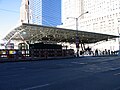
The current station is a temporary station that has opened since November 2003. Due to the redevelopment of the World Trade Center site, the entrances and size of the temporary station have changed over time. The most current entrance to the station is located at Vesey Street, facing Greenwich Street and adjacent to 7 World Trade Center.
The current entrance is a one story building on the south side of Vesey Street with a Hudson News outlet and escalators extending into a lower level mezzanine. A connection to Brookfield Place (New York City) was made available since October 27th, 2013 through a permanent passageway known as the West Concourse.
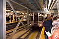
The station currently has three island platforms, one (platform A) is currently split by a wall. Tracks 2 and 3, and the New Track 4 are not currently used. The new Platform A, next to New Tracks 1 and 2, opened as part of the Transportation Hub on February 25, 2014.[3][4][5]
Station layout
| G | Street level | Entrances/exits, transfer to New York City Subway services outside of fare control ( |
| M | Mezzanine | Ticket machines, one-way faregates, concourse |
| P Platforms |
Track 1 | ← Template:PATH lines toward Hoboken (Exchange Place) |
| Island platform (Platform A), doors will open on the left | ||
| Wall | ||
| Island platform (Platform A), not in service | ||
| Track 2[note 1] | ← No regular service | |
| Track 3[note 2] | ← No regular service | |
| Island platform (Platform B), not in service | ||
| Track 4[note 3] | ← No regular service | |
| Temporary wall | ||
| Old Track 4[note 4] | ← Template:PATH lines toward Newark (Exchange Place) | |
| Island platform (Platform C), doors will open on the left, right | ||
| Old Track 5[note 5] | ← Template:PATH lines toward Newark (Exchange Place) | |
Adjacent transit connections
Unlike previous incarnations of the station, the current entrance does not have a direct connection to any adjacent subway station. Vesey Street has been pedestrianized to allow as a passageway between the World Trade Center subway station and the PATH station entrance.
| Station service legend | |
|---|---|
| Stops all times | |
| Stops all times except late nights | |
| Stops late nights only | |
| Stops weekdays during the day | |
| Stops rush hours in the peak direction only | |
| Time period details | |
| Station is compliant with the Americans with Disabilities Act | |
| Station is compliant with the Americans with Disabilities Act in the indicated direction only | |
| Elevator access to mezzanine only | |
The World Trade Center station is adjacent to several New York City Subway services:
| Services | Route | Station |
|---|---|---|
| 2 |
IRT Broadway – Seventh Avenue Line | Park Place |
| A |
IND Eighth Avenue Line | Chambers Street |
| E |
IND Eighth Avenue Line | World Trade Center |
| N |
BMT Broadway Line | Cortlandt Street |
The Fulton Street (New York City Subway) station complex (where the Fulton Center is under construction) is two blocks away to the east and features the following services:
| Service | Line |
|---|---|
| 2 |
IRT Broadway – Seventh Avenue Line |
| 4 |
IRT Lexington Avenue Line |
| A |
IND Eighth Avenue Line |
| J |
BMT Nassau Street Line |
The station complex will be linked to the WTC Transportation Hub by an underground passageway| as part of the Fulton Center project.
Additionally, the PATH station will be connected to the 1 ![]() train at the Cortlandt Street station on the IRT Broadway – Seventh Avenue Line. The station was previously connected to the 1971 station, but was severely damaged by the September 11th, 2001 attacks and is being rebuilt as part of the Transportation Hub.[6])
train at the Cortlandt Street station on the IRT Broadway – Seventh Avenue Line. The station was previously connected to the 1971 station, but was severely damaged by the September 11th, 2001 attacks and is being rebuilt as part of the Transportation Hub.[6])
The following NYCT buses could be found:
- M5: Northbound on Church Street, southbound to South Ferry on Broadway
History
Hudson Terminal

Hudson Terminal was built by the Hudson and Manhattan Railroad at the turn of the twentieth century and was located between Greenwich, Cortlandt, Church, and Fulton Streets. The Hudson Terminal included two 22-story office buildings located above the station.
The terminal was an architectural and engineering marvel of its time, designed with ramps to allow pedestrian traffic to flow in and out of the station quickly and easily.[7] The station was served by two single-track tubes connected by a loop to speed train movements. The loop included five tracks and 3 platforms (2 center island and one side) and is somewhat similar to the current arrangement.[8] By 1914, passenger volume at the Hudson Terminal had reached 30,535,500 annually.[7] Volume nearly doubled by 1922, with 59,221,354 passengers that year at the Hudson Terminal.[9]
Overall ridership on New Jersey's Hudson and Manhattan Railroad (H&M) declined substantially from a high of 113 million riders in 1927 to 26 million in 1958, after new automobile tunnels and bridges opened across the Hudson River.[10] The State of New Jersey was interested in getting the Port Authority to take over the railroad, but the Port Authority long viewed it as something unprofitable that they were never interested in. In the late 1950s, the Port Authority proposed to build a "world trade center" in New York City, on the east side of Lower Manhattan along the East River.
As a bi-state agency, Port Authority projects require approval from both the states of New Jersey and New York. Toward the end of 1961, negotiations with outgoing New Jersey Governor Robert B. Meyner regarding the World Trade Center project reached a stalemate. In December 1961, Port Authority executive director Austin J. Tobin met with newly elected New Jersey Governor Richard J. Hughes, and made a proposal to shift the World Trade Center project to a west side site where the Hudson Terminal was located.[11]
In acquiring the Hudson & Manhattan Railroad, the Port Authority would also acquire the Hudson Terminal and other buildings which were deemed obsolete.[11] On January 22, 1962, the two states reached an agreement to allow the Port Authority to take over the railroad and to build the World Trade Center on Manhattan's lower west side.[12] The shift in location for the World Trade Center to a site more convenient to New Jersey, together with Port Authority acquisition of the H&M Railroad, brought New Jersey to agreement in support of the World Trade Center project.
Original World Trade Center station
.jpg)
Groundbreaking on the World Trade Center took place in 1966. The site of the World Trade Center was located on landfill, with the bedrock located 65 feet (20 m) below.[13] A new method was used to construct a slurry wall that would keep water from the Hudson River out. During excavation of the site and construction of the towers, the original Hudson Tubes remained in service as elevated tunnels. The Hudson Terminal was shut down in 1971 when a new PATH station was completed.[14] The new WTC PATH station cost $35 million to build. At the time, the station had a passenger volume of 85,000 daily.[15]
.jpg)
The new PATH station opened on July 6, 1971, and was sited at a different location from the original Hudson Terminal.[16] The PATH station platform was slightly longer than its predecessor, accommodating 10-car trains versus the 6-car trains that the Hudson Terminal could handle. The tight turns in the loop into the Hudson Terminal were made less tight in the new station.[14] While construction of the World Trade Center neared completion, a temporary corridor was provided to take passengers between the station and a temporary entrance on Church Street. When it opened, the station had nine high-speed escalators between the platform level and the mezzanine level.[15] The WTC PATH station was served by Newark – World Trade Center and Hoboken – World Trade Center trains.
When the 1993 World Trade Center bombing occurred, a section of ceiling in the PATH station collapsed and trapped dozens.[17] Nonetheless, the PATH station did not suffer any structural damage.[18] Within a week, the Port Authority was able to resume PATH service to the World Trade Center.[19]
The PATH station was connected to the World Trade Center towers, via an underground concourse and shopping center. There were also underground connections to the New York City Subway (A, C, and E N, R, and W trains). Prior to September 11, the mall had been leased to The Westfield Group, which intended to rename the mall Westfield Shoppingtown World Trade Center, and embark on a major expansion and renovation program. Plans called for the addition of 200,000 square feet (19,000 m2) of new mall space and a few well-known sit-down restaurants. By 2001, the volume of passengers using the WTC PATH station was approximately 25,000 daily.[20]
Soon after American Airlines Flight 11 struck the North Tower of the World Trade Center at 08:46:40 EDT on September 11, 2001, the PATH station was shut down by order from deputy director Victoria Cross Kelly and Richie Moran, who commanded the system at the Journal Square Transportation Center. A train from Newark that came into the terminal at 8:55 am stopped only to pick up passengers. A second train, from Hoboken, came through at 9:00 am but did not stop and returned to New Jersey. PATH sent an empty train to the station at 9:10 am to pick up a dozen PATH employees and a homeless individual leaving the PATH station empty.[21]
Temporary PATH station
With the station destroyed, service to Lower Manhattan was suspended for over two years. Exchange Place, the next station on the Newark – World Trade Center line, also had to be closed because it could not operate as a terminal station. Instead, two uptown services (Newark – 33rd Street (red) and Hoboken – 33rd Street (blue)) and one intrastate New Jersey service (Hoboken – Journal Square (green)) were put into operation.[22]
Cleanup of the Exchange Place station was needed after the attacks. As well, the downtown Hudson tubes had been flooded, which destroyed the track infrastructure.[23] Modifications to the tracks were also required since the Exchange Place station was never designed as a terminal station.[22] The Exchange Place station re-opened in June 2003. PATH service to Lower Manhattan was restored when a temporary station opened on November 23, 2003. The inaugural train was the same one that had been used for the evacuation (see photo at left).
The temporary PATH station was designed by Port Authority chief architect Robert I. Davidson[24] and constructed at a cost of $323 million.[25] The station features a canopy entrance along Church Street and a 118-by-12 foot mosaic mural, “Iridescent Lightning,” by Giulio Candussio[24] of the Scuola Mosaicisti del Friuli in Spilimbergo, Italy. The station is also adorned with opaque panel walls inscribed with inspirational quotes attesting to the greatness and resilience of New York City. These panels partially shield the World Trade Center site from view.
In the 9/11 attacks, some sections of the station including the floor and the signage on the northeast corner, were only lightly damaged in the collapse of the World Trade Center. These sections of the station were retained in the temporary PATH station, and will remain in the new station, where it connects with the platforms for the A, C, and E 2 and 3 trains. Following its reopening and the resumption of Newark – World Trade Center and Hoboken – World Trade Center services, the station quickly reclaimed its status as the busiest station in the PATH system.
The World Trade Center PATH station was also home to a Storycorps booth which opened in 2005. Through this program, visitors could arrange to give oral recorded histories of the disaster. The booth closed in Spring 2007 to make way for construction at the World Trade Center site.[26] In June 2007, the street entrance to the temporary station was closed and demolished as part of the ongoing site construction. A set of new staircases was constructed several feet to the south, and a “tent” structure was added to provide cover from the elements. The tent structure, by Voorsanger Architects and installed at a cost of $275,000, was designed to have an “aspiring quality” according to architect Bartholomew Voorsanger.[27] That entrance on Church Street was closed in April 2008 when the entrance was relocated once again. On April 1, 2008, the third new temporary entrance to the PATH station opened for commuters. The entrance is located on Vesey Street, adjacent to 7 World Trade Center. It will serve as the entrance until the opening of the permanent station, designed by Calatrava.[28]
World Trade Center Transportation Hub
Background
| World Trade Center |
|---|
| Towers |
| Other elements |
| Artwork |
| History |


The temporary PATH station will be replaced with a permanent World Trade Center Transportation Hub, which is being built by the Port Authority of New York and New Jersey at an estimated cost of $3.44 billion. The design composed of a train station with a large and open mezzanine under the National September 11 Memorial plaza. The mezzanine is connected to an above ground head house structure, called the Oculus, located between 2 World Trade Center and 3 World Trade Center.[2][29][30]
A large transit station was not part of the 2003 Memory Foundations master plan for the site by Daniel Libeskind, which called for a smaller station along the lines of the original subterranean station that existed beneath the World Trade Center. Libeskind's design called for the Oculus space to be left open, forming a "Wedge of Light" so that sun rays around the autumnal equinox would hit the World Trade Center footprints each September.
In early 2004, the Port Authority, which owns the land, modified the Libeskind plan to include a large transportation station downtown, intended to rival Penn Station and Grand Central Terminal. In a nod to the Libeskind concept, the Oculus will be at an angle to maximize the effect of the autumnal equinox rays.
Since the Hudson Terminal was demolished, Lower Manhattan has not had an ambitious transit or railroad center, as the former complex at the World Trade Center was built beneath the buildings. The station is designed to connect the PATH to the New York City Subway system. An underground passageway east, along Dey Street, is being constructed as part of the Fulton Center project, which will link the new station with the subway's 1 2, 3, 4, 5, A, C, E, J, N, R, W, and Z services. There will also be a passageway west to the World Financial Center and the Battery Park City Ferry Terminal. A proposal for a connection to the Long Island Rail Road and John F. Kennedy International Airport via a new tunnel under the East River, the Lower Manhattan-Jamaica/JFK Transportation Project, was studied starting in 2004, but as of 2009 was a lower priority than other projects competing for funding.[31]
Design
Spanish Architect Santiago Calatrava, designer of the station, said the Oculus resembles a bird being released from a child's hand. The roof was originally designed to mechanically open to increase light and ventilation to the enclosed space. Herbert Muschamp, architecture critic of The New York Times, wrote:
Santiago Calatrava's design for the World Trade Center PATH station should satisfy those who believe that buildings planned for ground zero must aspire to a spiritual dimension. Over the years, many people have discerned a metaphysical element in Mr. Calatrava's work. I hope New Yorkers will detect its presence, too. With deep appreciation, I congratulate the Port Authority for commissioning Mr. Calatrava, the great Spanish architect and engineer, to design a building with the power to shape the future of New York. It is a pleasure to report, for once, that public officials are not overstating the case when they describe a design as breathtaking.[32]
Another critic wrote:
The World Trade Center PATH Terminal by Santiago Calatrava, the renowned Spanish architect and engineer, is what we should have at ground zero. Not modified suburban malls with water fountains, but a major cultural contribution to our city.[33]
However, Calatrava's original soaring spike design has been scaled back because of security issues. The Times observed:
In the name of security, Santiago Calatrava's bird has grown a beak. Its ribs have doubled in number and its wings have lost their interstices of glass.... [T]he main transit hall, between Church and Greenwich Streets, will almost certainly lose some of its delicate quality, while gaining structural expressiveness. It may now evoke a slender stegosaurus more than it does a bird.[34]
The design was further modified to eliminate the opening and closing roof mechanism because of budget and space constraints.[35]
The station has also stirred problems with developer Larry Silverstein, who owns the lease for the World Trade Center site, since it took away available space for his proposed buildings.
Construction
Construction of the station called for relocation of the landmark World Trade Center cross in 2006. The permanent station is scheduled to be completed and open on December 17, 2015.
On July 8, 2008, the first prefabricated "ribs" for the pedestrian walkway under Fulton Street were installed on the site.[36] The mezzanine level of the station is undergoing major construction and work on the foundation is still underway.[37]
As of March 1, 2011, over 225 of the 300 steel pieces which make up the roof of the station have been installed.[38] Later that month installation of the Vierendeel Truss, one of the hub's key components, began with the installation of a 50-ton section of the truss. When fully installed the combined weight of the truss will weigh 271 tons. The truss will serve as the mezzanine roof and also act as a support for the northeast corner of the WTC Memorial.[39]
By July 6, 2012, the following events were occurring:
- Steel erection for oculus substructure
- Construction connecting to Vehicular Security Center complex
- Greenwich Street corridor (1 train subway box): steel and concrete placing under 1 train subway box
- Preparations for installation of east arch truss
- Hub construction contract awarded to Skanska in summer 2010
As of June 2013[update], 10 pieces of exterior arches have been installed for the Oculus. The initial construction is expected to conclude in the end of 2014 or beginning of 2015, and the internal construction including paint, turnstiles, ticket booths, etc. is expected to complete in the end of 2015, with an official opening scheduled on December 17, 2015.[40]
By November 2013 about 110 arches, and the beginning of the wings have been installed.
By January 2014 about 130 arches, and the beginning of the wings have been installed
On February 25, 2014, the first platform of the new station, Platform A, was opened to the public with service to Hoboken. The new platform is fully modernized and contains new lighting, speakers, illuminated signs, escalators and elevators.[4]
West Concourse
The new West Street pedestrian underpass (the West Concourse, formerly the "east-west connector") links the WTC station mezzanine with Battery Park City's Brookfield Place (formerly World Financial Center) on the west side of the World Trade Center site just south of 1 WTC and across West Street. It opened on the afternoon of October 23, 2013.[41][42]
Gallery
-
 Inaugural train arrives from Newark at PATH's temporary WTC station at 2:08 pm, November 23, 2003. Note passengers on platforms applauding its arrival
 -
 Temporary entrance on Church Street in 2005
 -
 Hoboken-bound train at the World Trade Center PATH station (2005)
 -
 Temporary WTC PATH Station (2005) with one-way faregates
 -
 Newark-bound PA-5 train at the World Trade Center PATH station (February 27, 2009)


See also
References
- ^ "Project Updates: World Trade Center Transportation Hub". Lower Manhattan Construction Command Center. Retrieved September 2, 2010.
- ^ a b Grynbaum, Michael M. (February 24, 2011). "Trade Center Transit Hub's Cost Now Over $3.4 Billion". The New York Times. Retrieved February 25, 2011.
- ^ Hinds, Kate. "Photos That Will Make You Want To Ride The PATH Train". WNYC. Retrieved February 27, 2014.
- ^ a b "Port Authority to open first platform for new World Trade Center PATH station | 7online.com". Abclocal.go.com. Retrieved February 27, 2014.
- ^ "Port Authority Opens First Platform At New WTC PATH Station « CBS New York". Newyork.cbslocal.com. Retrieved February 27, 2014.
- ^ Work at Cortlandt Street station #1 train continues above ground at WTC Transportation Hub
- ^ a b Droege, John Albert (1916). Passenger Terminals and Trains. McGraw-Hill. pp. 157–159.
- ^ Cudahy, Brian J. (2002). Rails Under the Mighty Hudson. Fordham University Press. pp. 59–60.
- ^ "315,724,808 Came or Left City in 1922". The New York Times. April 15, 1923. p. E1. Retrieved May 30, 2010.
- ^ Cudahy, Brian J. (2002). Rails Under the Mighty Hudson. Fordham University Press. p. 56.
- ^ a b Grutzner, Charles (December 29, 1961). "Port Unit Backs Linking of H&M and Other Lines". The New York Times. p. 1. Retrieved May 30, 2010.
- ^ Wright, George Cable (January 23, 1962). "2 States Agree on Hudson Tubes and Trade Center". The New York Times. p. 1. Retrieved May 30, 2010.
- ^ Iglauer, Edith (November 4, 1972). "The Biggest Foundation". The New Yorker.
- ^ a b Carroll, Maurice (December 30, 1968). "A Section of the Hudson Tubes is Turned into Elevated Tunnel". The New York Times. p. 33. Retrieved May 30, 2010.
- ^ a b "Air-Cooled PATH Terminal in World Trade Center Opens Tuesday". The New York Times. July 1, 1971. p. 94. Retrieved May 30, 2010.
- ^ Burks, Edward C. (July 7, 1971). "New PATH Station Opens Downtown". The New York Times. p. 74. Retrieved May 30, 2010.
- ^ McFadden, Robert D. (February 27, 1993). "Blast Hits Trade Center, Bomb Suspected; 5 Killed, Thousands Flee Smoke In Towers". The New York Times.
- ^ Newkirk, Pamela (February 28, 1993). "Now, the Cleanup, Work begins assessing the damage". Newsday. New York.
- ^ Marks, Peter (March 1, 1993). "PATH and Subway Service Is Being Restored". The New York Times.
- ^ Wyckoff, P.L. and Rudy Larini (September 13, 2001). "Next Stop, Semi-Normalcy". The Star-Ledger. Newark.
- ^ Schwaneberg, Robert (September 19, 2001). "Quick-Acting P.A. Steered 5,000 Commuters to Safety". The Star-Ledger. Newark.
- ^ a b "PATH Service Restoration". Port Authority of New York and New Jersey. Archived from the original on March 6, 2008. Retrieved April 22, 2008.
- ^ "Temporary World Trade Center PATH Station". New York Construction. Retrieved April 22, 2008.
- ^ a b Dunlap, David W. (May 15, 2003). "At Ground Zero, a Conduit of People and Memory". The New York Times. p. B3. Retrieved May 30, 2010.
- ^ Dunlap, David W. (November 24, 2003). "Again, Trains Put the World In Trade Center". The New York Times. p. A1.
- ^ "About the World Trade Center". Silverstein Properties. Retrieved April 20, 2008.
- ^ Dunlap, David W. (April 10, 2008). "Folding a Large and Symbolic Tent Downtown". The New York Times.
- ^ Dunlap, David W. (April 1, 2008). "A New Twist at the PATH Station". The New York Times.
- ^ Calatrava's WTC Transportation Hub Soars – lowermanhattan.info
- ^ Gralla, Joan (October 2, 2008). "NYC World Trade Center site faces fresh delays". Yahoo! News. Retrieved October 3, 2008. [dead link]
- ^ Brown, Eliot (March 24, 2009). "The Tunnel From Nowhere". New York Observer. Retrieved February 28, 2010.
- ^ Muschamp, Herbert (January 23, 2004). "AN APPRAISAL; PATH Station Becomes A Procession of Flight". The New York Times. Retrieved July 13, 2008.
- ^ Kimmelman, Michael (February 1, 2004). "ARCHITECTURE; Ground Zero Finally Grows Up". The New York Times. Retrieved July 13, 2008.
- ^ Dunlap, David W. (July 28, 2005). "Approval Expected Today for Trade Center Rail Hub". The New York Times. Retrieved July 13, 2008.
- ^ Dunlap, David W. (July 2, 2008). "Design of Ground Zero Transit Hub Is Trimmed". The New York Times. Retrieved July 13, 2008.
- ^ Dunlap, David W. (July 11, 2008). "Among the Hard Angles, a Few New Curves". The New York Times. Retrieved July 13, 2008.
- ^ "PANYNJ continues to post progress on WTC Transportation Hub". Progressive Railroading. October 25, 2010. Retrieved October 25, 2010.
- ^ "World Trade Center Transportation Hub". Port Authority of New York & New Jersey. Retrieved October 2, 2011.
- ^ "World Trade Center Image Gallery". Port Authority of New York & New Jersey. Retrieved October 2, 2011.
- ^ "Transportation Hub - World Trade Center". Panynj.gov. Retrieved February 27, 2014.
- ^ New PATH tunnel opens this week wnyc.org, Monday, October 21, 2013 - 10:42 PM By JESSICA GOULD
- ^ "Lower Manhattan : World Trade Center Transportation Hub". Lowermanhattan.info. October 24, 2013. Retrieved February 27, 2014.
External links
- PATH – World Trade Center
- nycsubway.org
- Vesey Street entrance from a block away from Google Maps Street View
- WTC Transportation Hub under construction from Google Maps Street View
| Services |  | |
|---|---|---|
| Stations | ||
| Infrastructure | ||
| Historical/Former | ||
| Fares | ||
| Related | ||