
St. Martins, New Brunswick: Difference between revisions
→top: Unincorporated community (former village) |
eew i lov e to dissolve things Tag: Reverted |
||
| Line 3: | Line 3: | ||
{{Infobox settlement |
{{Infobox settlement |
||
|official_name = St. Martins |
|official_name = St. Martins |
||
|settlement_type = |
|settlement_type = commnity |
||
|image_skyline = St Martins NB covered bridge.jpg |
|image_skyline = St Martins NB covered bridge.jpg |
||
|image_caption = St. Martins and its twin [[covered bridge]]s |
|image_caption = St. Martins and its twin [[covered bridge]]s |
||
| Line 14: | Line 14: | ||
|subdivision_name = Canada |
|subdivision_name = Canada |
||
|subdivision_type1 = [[Provinces and territories of Canada|Province]] |
|subdivision_type1 = [[Provinces and territories of Canada|Province]] |
||
extinct_title = Dissolved |
|||
| extinct_date = 2023 |
|||
| subdivision_type3 = [[List of parishes in New Brunswick|Parish]]|subdivision_name1 = [[New Brunswick]] |
|||
|subdivision_type2 = [[Counties of New Brunswick|County]] |
|subdivision_type2 = [[Counties of New Brunswick|County]] |
||
|subdivision_name2 = [[Saint John County, New Brunswick|Saint John County]] |
|subdivision_name2 = [[Saint John County, New Brunswick|Saint John County]] |
||
Revision as of 04:17, 1 April 2023
St. Martins | |
|---|---|
commnity | |
 St. Martins and its twin covered bridges | |
 St. Martins Location of St. Martins in New Brunswick  St. Martins St. Martins (Canada) | |
| Coordinates: 45°21′1.6″N 65°32′2.3″W / 45.350444°N 65.533972°W | |
| Country | Canada |
| Province extinct_title = Dissolved | New Brunswick |
| County | Saint John County |
| Parish | Saint Martins Parish |
| Area | |
| • Land | 2.35 km2 (0.91 sq mi) |
| Population | |
| • Total | 320 |
| • Density | 136.1/km2 (352/sq mi) |
| • Change 2016–21 | |
| Time zone | UTC-4 (Atlantic) |
| • Summer (DST) | UTC-3 (ADT) |
| Area code | 506 |
| Website | www |
| Quaco Head Lighthouse | |
| Constructed | 1835 (first) 1883 (second) |
| Foundation | Concrete base |
| Construction | Concrete tower (current) |
| Height | 11 m (36 ft) |
| Shape | Quadrangular tower with balcony and lantern[2][3][4] |
| Markings | White tower, red lantern |
| Power source | solar power |
| Operator | Canadian Coast Guard |
| Fog signal | 3s. blast every 30s. |
| First lit | 1966 (current) |
| Deactivated | 1881 (first, destroyed by fire) 1966 (second) |
| Focal height | 26 m (85 ft) |
| Range | 21 nmi (39 km; 24 mi) |
| Characteristic | Fl W 10s |
St. Martins is a community on the Bay of Fundy in Saint John County, New Brunswick, Canada.
The village was founded as Quaco by 1783 by soldiers from the disbanded loyalist King's Orange Rangers. It was incorporated in 1967. Led by shipbuilders such as James Moran, it was the third most productive shipbuilding town in the Maritimes, producing over 500 ships.[5] Shipbuilding declined after the 1870s and today tourism is the major industry.[6]
On 1 January 2023, St. Martins annexed all or part of three local service districts to form the new village of Fundy-St. Martins.[7][8] The community's name remains in official use.[9]
Attractions
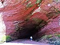
Attractions in St. Martins include the St. Martins Sea Caves,[10] the beach and tidal harbour,[11] the start of the Fundy Trail,[12] two covered bridges and the Quaco Head Lighthouse, the Quaco Museum and Library,[13] and the Fundy Trail Parkway.[14]
Demographics
In the 2021 Census of Population conducted by Statistics Canada, St. Martins had a population of 320 living in 157 of its 194 total private dwellings, a change of 15.9% from its 2016 population of 276. With a land area of 2.35 km2 (0.91 sq mi), it had a population density of 136.2/km2 (352.7/sq mi) in 2021.[1]
Gallery
-
 St. Martins' Caves
 -
 Fundy Trail
 -
 Twin covered bridges
 -
 St Martins Sea Cave


Further reading
- Hebb, Ross M., Quaco - St. Martins: A Brief History, 1997. Fredericton, NB: Quaco/Springhill Press. ISBN 0-9682579-0-9
See also
- List of lighthouses in New Brunswick
- List of communities in New Brunswick
- History of New Brunswick
- List of historic places in Saint John County, New Brunswick
References
- ^ a b c d "Census Profile of St. Martins, Village (VL)". Statistics Canada. 6 December 2022. Retrieved 21 January 2023.
- ^ List of Lights, Pub. 110: Greenland, The East Coasts of North and South America (Excluding Continental U.S.A. Except the East Coast of Florida) and the West Indies (PDF). List of Lights. United States National Geospatial-Intelligence Agency. 2015.
- ^ Rowlett, Russ. "Lighthouses of Canada: Southern New Brunswick". The Lighthouse Directory. University of North Carolina at Chapel Hill. Retrieved 29 March 2017.
- ^ "Quaco Head, NB". Lighthouse Friends. Retrieved 29 March 2017.
- ^ "Living History". Archived from the original on 4 August 2017. Retrieved 14 September 2017.
- ^ "Village of St. Martins". Retrieved 14 September 2017.
- ^ "Local Governments Establishment Regulation – Local Governance Act". Government of New Brunswick. 12 October 2022. Retrieved 21 January 2023.
- ^ "RSC 9 Fundy Regional Service Commission". Government of New Brunswick. Retrieved 21 January 2023.
- ^ "Proposed entity names reflect strong ties to nature and history" (Press release). Irishtown, New Brunswick: Government of New Brunswick. 25 May 2022. Retrieved 21 January 2023.
- ^ "St. Martins Sea Caves". Retrieved September 14, 2017.
- ^ "Tidal Harbour". Retrieved September 14, 2017.
- ^ "Awe-inspiring Fundy Trail". Retrieved September 14, 2017.
- ^ "Quaco Museum". Quaco Historical & Library Society. Retrieved September 14, 2017.
- ^ "Fundy Trail Parkway". Retrieved September 29, 2019.
- ^ "Census Profile, 2016 Census: St. Martins, Village [Census subdivision], New Brunswick". Statistics Canada. Retrieved September 29, 2019.
External links
Subdivisions of New Brunswick | |
|---|---|
| Cities | |
| Towns |
|
| Villages | |
| Regional municipality | |
| Rural communities | |
| Rural districts |
|
| Regional service commissions | |
| School districts | |
| Indian reserves |
|
| Non-administrative divisions | |
| International | |
|---|---|
| National | |
| Geographic | |
| Quaco Head Lighthouse | |