
Rockall: Difference between revisions
Undid revision 278703803 by 82.6.12.186 (talk) |
Both Ireland and Britain are islands also. |
||
| Line 31: | Line 31: | ||
Rockall is also close to the [[Darwin Mounds]], deep-water [[coral]] mounds about 185 km (100 nmi or 115 mi) north-west of [[Cape Wrath]]. |
Rockall is also close to the [[Darwin Mounds]], deep-water [[coral]] mounds about 185 km (100 nmi or 115 mi) north-west of [[Cape Wrath]]. |
||
===Nearest mainland=== |
|||
*{{convert|424|km|mi}} north-west of Donegal on the mainland of the republic of [[Republic of Ireland|Ireland]]. |
|||
*{{convert|461.5|km|mi}} from [[Ardnamurchan Point]], the nearest point on the Scottish mainland, and thus of mainland [[Great Britain]].<ref>Point of Ardnamurchan. Ordnance Survey grid reference "141499.7,767502.0". O.S Coordinate transformer = ETRS89 56°43’38.34029”N 6°13’38.78674”W. Distance to Rockall 461.468km (286.743mi)</ref> |
|||
===Nearest islands=== |
===Nearest islands=== |
||
Revision as of 12:03, 21 March 2009


Rockall is a small, uninhabited, rocky islet in the north Atlantic Ocean, and one of the sea areas named in the Shipping Forecast broadcast on BBC Radio 4. It could be, in James Fisher's words, "the smallest isolated rock, or the most isolated small rock (both ways will do), in the oceans of the world".[1]
The ownership of Rockall is disputed as are the exploration and fishing rights on the Rockall Bank. A meeting between the countries involved (the United Kingdom, Denmark (for the Faroe Islands), Ireland and Iceland), is scheduled for May 2009.
Etymology
The origin of the name is debatable but it has been suggested that it derives from the Scottish Gaelic Sgeir Rocail meaning "skerry (or "sea rock") of roaring",[2] although rocail can also be translated as "tearing" or "ripping".[3][4] There may also be an etymological link with the old Norse hrukka.
The first literary reference to the isle, where it is called Rockol, is found in Martin Martin's A Description of the Western isles of Scotland published in 1703 where he gives an account of a voyage to St Kilda where the locals knew the isle as Rockabarra (Rocabarraigh).[5] The name Rocabarraigh is also used in Gaelic folklore for a mythical rock which is supposed to appear three times, the last being at the end of the world.
- "Nuair a thig Rocabarra ris, is dual gun tèid an Saoghal a sgrios".
- (When Rocabarra returns, the world will likely come to be destroyed/ruined)
Geography

The rock is the summit of the eroded core of an extinct volcano and is located at 57°35′48″N 13°41′19″W / 57.59667°N 13.68861°W, 301.4 kilometres (187.3 mi) (or 162.7 nmi) [6] west of the islands of St. Kilda, Scotland and 424 kilometres (263 mi) north-west of Donegal in Ireland. The surrounding elevated seabed is called Rockall Bank or Rockall Plateau. It is separated from the Western Isles by Rockall Channel (also called Rockall Trough). Anton Dohrn Seamount is a submarine elevation on Rockall Trough about halfway between Rockall and the Outer Hebrides.
Rockall is mapped by the Ordnance Survey, but as it is officially outside the OSGB grid it is usually shown as an inset without gridlines on a mainland sheet. However, the grid can be extended to put Rockall in grid square MC as shown in this 1:50,000 mockup.
Rockall is about 25.3 metres (83 ft) wide and 31 metres (102 ft) long at its base[7] and rises sheer to a height of approximately 21.4 metres (70 ft).[8] It is regularly washed over by large storm waves, particularly in winter. There is a small ledge of 3.5 by 1.3 metres (11 by 4 ft), known as "Hall's Ledge", 4 metres (13 ft) from the summit.[9]
The rock's only permanent inhabitants are periwinkles and other marine molluscs. Small numbers of seabirds, mainly fulmars, gannets, kittiwakes, and guillemots, use the rock for resting in summer, and gannets and guillemots occasionally breed successfully if the summer is calm with no storm waves washing over the rock. There is no natural source of fresh water.
Rockall is also close to the Darwin Mounds, deep-water coral mounds about 185 km (100 nmi or 115 mi) north-west of Cape Wrath.
Nearest islands
Rockall lies:
- 301.4 kilometres (187.3 mi) (or 162.7nmi) [6] west of the Scottish island of Soay in the St Kilda archipelago. Soay has probably never been permanently inhabited.
- 303.3 kilometres (188.4mi) (or 163.8nmi) [10] west of Hirta, the largest island in the St Kilda group. Hirta was permanently inhabited until 1930 when the resident population was evacuated.[11] Since 1957 Hirta has been re-occupied year-round by a small number of civilians working in a military base.[12]
- 367 kilometres (228 mi) (or 198.1nmi)[13] west of the headland of Aird an Runair, near the crofting township of Hogha Gearraidh / Hougharry[14] 57°36′33″N 7°31′9″W / 57.60917°N 7.51917°W on the island of North Uist at Ordnance Survey grid reference NF705711. North Uist is part of the Na h-Eileanan Siar council area of Scotland.
Geological surveys

The exact position of Rockall and the size and shape of the Rockall Bank was first charted in 1831 by Captain A.T.E. Vidal, a Royal Navy surveyor.
The first scientific expedition to Rockall was led by Miller Christie in 1896 when the Royal Irish Academy sponsored a study of the flora and fauna.[16] They chartered the Granuaile.[17][1]
The RV Celtic Explorer has surveyed the Rockall Bank and North West of Donegal in 2003.[18]
The ILV Granuaile was chartered by the Geological Survey of Ireland (GSI), on behalf of the Department of Communications, Marine and Natural Resources (DCMNR), to conduct a seismic survey at the Rockall and Hatton Banks in July 2004.[19] The seismic survey was part of the National Seabed Survey which has been ongoing for four years.[19]
Rockall is made of a type of granite that is relatively rich in sodium and potassium. Within this granite are darker bands richer in the alkali pyroxene mineral aegirine and the alkali amphibole mineral riebeckite. The dark bands are a variety of granite commonly known as rockallite. In 1975, a new mineral was discovered on Rockall. The mineral is called bazirite, named after the elements barium and zirconium and has the chemical composition BaZrSi3O9.[20] Rockall was formed approximately 55 million years ago, when the ancient continent of Laurasia was split apart by plate tectonics. Greenland and Europe separated and the north-east Atlantic Ocean was formed between them.[21]
Disasters
There have been disasters on the neighbouring Hasselwood Rock and Helen's Reef (the latter was not named until 1830).
- 1686 — a Spanish, French, or Spanish-French ship ran on Rockall. Several men of the crew, Spanish and French, were able to reach St. Kilda in a pinnace and save their lives. Some details of this event were recounted by Martin Martin in his A late voyage to St. Kilda, published in 1698. The ship was perhaps a fishing vessel based in the Bay of Biscay and bound for North Atlantic cod fisheries.
- 1812 — survey vessel Leonidas foundered on Helen's Reef.
- 1824 — brigantine Helen of Dundee, bound for Quebec, foundered at Hasselwood Rock; "the crew left most of the passengers to drown, including seven women and six children".
- 1904 — DFDS steamer SS Norge, 3,318 tons with 727 emigrants and a crew of 68, bound for New York on 28 June 1904; 635 lives were lost with the 163 survivors being taken to Stornoway.[2]
There have also been reports in national newspapers in both Ireland and the United Kingdom that at least two unexploded bombs from World War II lie within a 250-metre radius of Rockall. At present, no attempts have been made to remove them.
Law of the Sea
The United Nations Convention on the Law of the Sea states, “Rocks which cannot sustain human habitation or economic life of their own shall have no exclusive economic zone or continental shelf.” Ireland, Denmark, and Iceland all acceded to the convention. The United Kingdom acceded to the convention on 25 July 1997. The United Kingdom and Ireland have agreed to a delineation which ignores Rockall's existence and have granted exploration rights.[22]
History and conflicting claims
Irish claims to areas around Rockall
Historically, Ireland's claim was based on its distance from a mainland.[23] (Ireland being nearer to the rock than mainland Great Britain) while Britain's was based on its distance from nearby islands. Ireland no longer has a formal claim to Rockall, regarding it as merely an uninhabitable rock without any territorial waters and thus irrelevant when determining the boundaries of the exclusive economic zones of Denmark, Ireland, Iceland, and the United Kingdom. More populist claims to the island are based, in part, on the fact that Rockall is 424 kilometres (265 miles) from Donegal in Ireland.[24]
According to a Written Parliamentary Answer from the Irish Minister of Foreign Affairs on 14 June 1990, an agreement[22] was reached between the British and Irish governments on delimitation of the continental shelf between the two countries and that this included a line of delimitation across the Rockall Plateau.[25] As a result, a very extensive area under Irish jurisdiction, including part of the Rockall Trough and Plateau, is not disputed by the United Kingdom. No further negotiations were taking place in relation to the rock at the time.
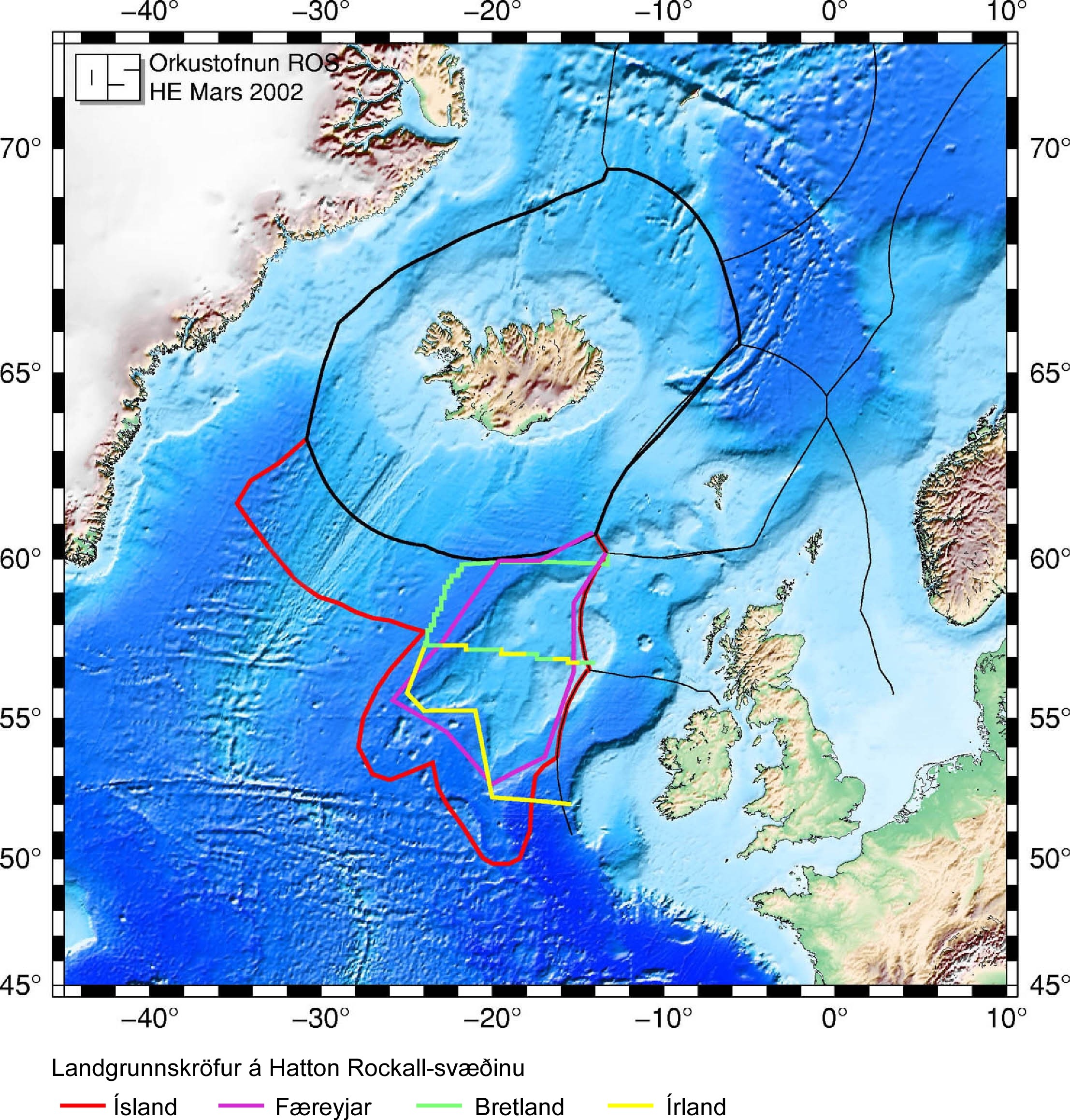
More recently, on 11 June 2003, the Irish Minister for Communications, Marine and Natural Resources gave a Written Parliamentary Answer, stating: "Ireland claims an extended continental shelf … up to more than 500 nautical miles (926 km), particularly in the Hatton–Rockall area".[26]
As the United Nations[27] has no mandate regarding issues of delimitation between neighbouring states and cannot consider an area under dispute without the agreement of all the parties concerned, Ireland has participated in informal discussions with Iceland and the Faroe Islands in an attempt to resolve the dispute before making its submission to the Commission.
Independent Irish politician Seán Dublin Bay Rockall Loftus (b. 1927), a former Lord Mayor of Dublin (1995–1996), has long advocated that Ireland make a territorial claim on Rockall, and enthusiastically supported Greenpeace's occupation. Loftus, who had changed his name by deed poll to "Seán Dublin Bay Loftus" to highlight his campaign for the protection of the environment of Dublin Bay, changed it again, adding "Rockall" to demonstrate his commitment to an Irish claim on the islet.
The United Kingdom's claims
Rockall is within the Exclusive Economic Zone (EEZ) of the United Kingdom if demarcation agreements were made between the UK and each of its neighbours.[28][29] In 1997, the UK ratified[30] the United Nations Convention on the Law of the Sea and thus relinquished any claim to an extension of its EEZ beyond the islet. The remaining issue is the status of the continental shelf rights of surrounding ocean floor. These are the exclusive rights to exploit any resources on or under the ocean floor (oil, natural gas, etc.) and should not be confused with the EEZ, as continental shelf rights do not carry any privileges with regard to fisheries. Ownership of these rights in the Rockall area are disputed between the United Kingdom, Denmark (for the Faroe Islands), Ireland and Iceland.
The United Kingdom formally annexed Rockall under the Island of Rockall Act 1972.

The nearest permanently inhabitable land to Rockall is Hirta, and the nearest actually inhabited land is North Uist, both of which are in the United Kingdom (see above). In 1997 the United Kingdom ratified the 1982 United Nations Convention on the Law of the Sea. In doing so it relinquished its right to claim an exclusive economic zone (EEZ) of 200 nmi (370 km) extending onward from the rock, as the agreement states that "Rocks which cannot sustain human habitation or economic life of their own shall have no exclusive economic zone or continental shelf". However, as Rockall lies within 200 nmi (370 km) of both St Kilda and North Uist, the island itself remains within the EEZ of the United Kingdom and as such, under international law the UK can claim "..the sovereignty of the coastal state in relation to the exploitation, conservation and management of natural and living resources fishery and mineral resources" of the rock itself and an area of territorial waters extending for 12 nmi (22 km) around it. Furthermore, the United Kingdom and Ireland have signed a boundary agreement which includes Rockall in the United Kingdom area.
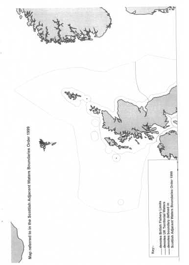
Rockall, and a large sea area around it, was declared as coming under the jurisdiction of Scots law under the Scottish Adjacent Waters Boundaries Order (map) in 1999.
The earliest recorded landing on the island was on 8 July 1810 when a Royal Navy officer named Basil Hall led a small landing party from the frigate HMS Endymion to the summit. The frigate was taking depth measurements around Rockall when it drifted away in a haze. The expedition made a brief attempt to find the frigate in the haze, but soon gave up and returned to Rockall. After the haze became a fog, the lookout sent to the top of Rockall spotted the ship again, but it turned away from Rockall before the expedition in their boats reached it. Finally, just before sunset, the frigate was again spotted from the top of Rockall, and the expedition was able to get back on board. The crew of the Endymion reported that they had been searching for five or six hours, firing their cannon every ten minutes. Hall related this experience and other adventures in a book entitled Fragment of Voyages and Travels Including Anecdotes of a Naval Life.
The next landing was accomplished by a Mr Johns of HMS Porcupine, whilst the ship was on a mission, from June and August 1862, to make a survey of the sea bed prior to the laying of a transatlantic telegraph cable. Johns managed to gain foothold on the island, but failed to reach the summit.
On 18 September 1955 at precisely 10.16 am, in what would be the final territorial expansion of the British Empire, the island was officially annexed by the UK when Lieutenant-Commander Desmond Scott RN, Sergeant Brian Peel RM, Corporal AA Fraser RM, and James Fisher (a civilian naturalist and former Royal Marine), were deposited on the island by a Royal Navy helicopter from HMS Vidal (coincidentally named after the man who first charted the island). The team cemented in a brass plaque on Hall's Ledge and hoisted the Union Flag to stake the UK's claim.
The inscription on the plaque reads:
- "By authority of Her Majesty Queen Elizabeth II, by the Grace of God of the United Kingdom of Great Britain and Northern Ireland and of her other realms and territories Queen, Head of the Commonwealth, Defender of the Faith, and in accordance with Her Majesty's instructions dated the 14th day of September, 1955, a landing was effected this day upon this island of Rockall from HMS Vidal. The Union flag was hoisted and possession of the island was taken in the name of Her Majesty. [Signed] R H Connell, Captain, HMS Vidal, 18 September 1955."
The formal annexation of Rockall was announced by the Admiralty on 21 September 1955.
The initial incentive for the annexation of Rockall had little to do with any territorial claim to rights of exploitation of the seas around the island. It was the test firing of the UK's first guided nuclear weapon, the American-made Corporal missile. The missile was to be launched from South Uist and over the North Atlantic. The Ministry of Defence was concerned that the unclaimed island would provide a unique opportunity for the Soviet Union to spy on the test by placing surveillance equipment on the island; and so in April 1955 a request was sent to the Admiralty to seize the island, and declare UK sovereignty lest it become an outpost for foreign observers.
On 10 February 1972 the Island of Rockall Act received Royal Assent to make the island administratively part of the Isle of Harris (St Kilda being administratively part of Harris), in what was then Inverness-shire, fully incorporating it into the United Kingdom. A navigational beacon was later installed on the island and the UK declared that no ship would be allowed within a 50-mile (80 km) radius of the rock. In United Kingdom law, it now falls administratively under the Outer Hebrides.
Former SAS member and survival expert Tom McLean lived on the island from 26 May 1985 to 4 July 1985 to affirm the UK's claim to the island.[31]
Rockall 2011 (http://www.rockall2011.com/Rockall_2011_Home_Page.html) is an expedition to be undertaken by Nick Hancock in order to raise money for the charity Help for Heroes. The challenge is to land on Rockall and survive solo for 60 days on this isolated rock thereby setting two new records:
1. The longest occupation of Rockall in history;
2. The longest ever solo occupation of Rockall.
It is proposed that this landing will coincide with the 200th anniversary of the first recorded landing on Rockall, by the Royal Navy in 1811.
Icelandic claims in the area
Iceland does not claim the rock itself, considering it irrelevant as far as delimitation of EEZs and continental shelf is concerned. Iceland however claims an extended continental shelf in the Hatton-Rockall area.
Iceland considers St Kilda to be "a minuscule, effectively uninhabited, islet, categorized under article 121(3) of the Law of the Sea Convention". Furthermore St Kilda lies outside the British territoral sea limit. Therefore it is not an "equitable basepoint for an equidistant line".[32]
Iceland ratified UNCLOS in 1985; it was the first Western country to do so. A regulation was issued by the government in that same year outlining the area where Iceland claimed continental shelf rights for itself; the regulation was based on legislation from 1979 claiming for Iceland the exclusive right to research and exploitation of continental shelf-based resources within the limits of the Icelandic continental shelf. Regarding the Hatton-Rockall area, it claims the area within 60 nautical miles (110 km) from the foot of the continental shelf and assumes that the UK and Ireland cannot claim a continental shelf outside their EEZs. To its fullest extent, this area reaches about 700 nautical miles (1,300 km) to the south from Iceland's coast, which is further south than the United Kingdom's southernmost point.
In 2001, Iceland began working on its submission to the Commission on the Limits of the Continental Shelf; it is scheduled to finish in 2007. The most important aspect of this work is to survey the entire ocean floor in the areas claimed outside the EEZ and, in Iceland's case, a part of the area inside the EEZ as well. In all, 1.3 million square kilometres (500,000 sq mi) have been surveyed by Icelandic marine research institutions for this purpose, an area 13 times larger than the land area of Iceland. The commission does however not make proposals regarding areas that are claimed by two or more states unless they have already reached an agreement on its division. Therefore Iceland's submission is expected to deal only with the area that just Iceland has claimed and not the Hatton-Rockall area. Iceland also hosted an informal meeting of all parties to the dispute in 2001. It was the first such meeting regarding the dispute where all four countries participated.
Danish/Faroese claims in the area
The Faroe Islands are an autonomous region of the Kingdom of Denmark. Since 1948 they have had self-government in almost all matters except defence and foreign affairs. Consequently their interests in Rockall are represented by Denmark. On their behalf, Denmark claims continental shelf rights in the Hatton-Rockall area. A communiqué issued by the Prime Minister's Office on 7 May 1985 announced the designation of not only the seabed in the immediate vicinity of the Faroes but also a vast area of the Rockall plateau to the south west. The press release which accompanied the communiqué indicated that the legal basis of this designation was the assumption that "the Faroe Islands are part of the microcontinent" formed by the "Faroes-Rockall Plateau", an "elevated plain with its summit in the Faroe Islands". [33]
Waveland and the Greenpeace occupation
In 1997 the environmentalist organisation Greenpeace occupied the islet for a short time,[34] calling it Waveland, to protest against oil exploration under the authority of the British. Greenpeace declared the island to be a “new Global State”, and offered citizenship to anyone willing to take their pledge of allegiance. The British Government's response was simply to give them permission to be there, and otherwise ignore them. Indeed, when asked, the Home Office responded that since Rockall was part of the United Kingdom, and since the UK was a free country, Greenpeace were perfectly entitled to be at Rockall.
The project continued until 1999, when the company sponsoring it collapsed and the experiment ended.
Negotiations
Ongoing talks have been held over the last five years with the aim of reaching an agreement which will end the dispute over territorial rights to Rockall-Hatton basin.
Reykjavík conference
Representatives from the UK, Ireland, Iceland and Denmark (the latter acting on behalf of the Faroe Islands), met in Reykjavík, Iceland for negotiations over territorial rights over the continental shelf in the area. The final boundary will be determined by the United Nations Commission on the Limits of the Continental Shelf. The parties have until May 2009 to submit reports to the commission, which it will take into account when determining the boundary. The involved nations have the option of submitting separate reports, or a joint one.
Ownership of the rock itself did not form part of the negotiations.[35]
Copenhagen conference
In November 2007 talks were held in Copenhagen. Here a template for a deal was secured by Irish, Danish, British and Icelandic diplomats.
Dublin conference
As a follow-up to Copenhagen, the Government of Ireland will host negotiations. They were due to commence in January 2008, but have been postponed because of elections in the Faroe Islands. The talks are hoped to bring the four nations closer to reaching an agreement over the Rockall-Hatton basin. It is understood a final deal is not likely to be agreed at the Dublin meeting.[36]
The Irish Minister for Foreign Affairs, Dermot Ahern said "There have certainly been protracted talks, but that is not unusual when one considers the complexity of the issue at hand and the competing interests. However, there was some progress made at the last talks in Copenhagen. I believe further progress can be made in Dublin. The deadline is May 2009 so we have time on our hands. It is in the interests of Ireland, UK, Denmark and Iceland to come to a deal on the division of the seabed area. We have come to outline agreements in relation to other parts of our seabed in the Atlantic. There is no reason ultimately why we also can't do a deal on this protracted issue. Finding a deal is a significant challenge but the rewards are there for future generations from all four countries"
Amateur radio visit
There has been one charity fundraiser visit to Rockall in 2005, reported in the Rockall Times[37] and The Register [38], which included photographs, an amateur radio broadcast and some stamp cancellations, following on an unsuccessful attempt in 2003. The following year a second was planned. The high cost of this visit led to its cancellation. An attempt to reach the rock was made in May 2008, but the high seas prevented a landing. A new expedition was also considered for June 2008, but was cancelled due to the riskiness of the undertaking, and the high cost of travel to the island.[39]
References to Rockall in popular culture
- It has been suggested that Rockall is the rock which forms the setting for William Golding's novel Pincher Martin.
- The 1955 British landing, complete with the trappings of hoisting the flag etc., caused a certain amount of popular amusement, with some seeing it as a sort of farcical end to imperial expansion. The satirists Flanders and Swann sang a successful piece entitled "Rockall", playing on the similarity of the word to a then taboo expression.
- Popular Irish rebel music band, the Wolfe Tones sing a song called "Rock on Rockall" that argues against the supposed British ownership of the rock and supports an Irish claim.[40]
- The Master, a 1957 novel by T. H. White, is set on Rockall.[41]
- English post-punk band Gang of Four reference the rock in the 1979 song "Ether" (from the album Entertainment!), in the line "There may be oil ... under Rockall," possibly a reference to the disputed exploitation rights.
- Icelandic jazz-funk band Mezzoforte in 1983 released a piece of music entitled Rockall
- Musty Mind, the parody of Mastermind on the lunchtime radio programme of Noel Edmunds featured a send-up subject, The Cultural and Social History of Rockall
- Rockall was the launching site for the prototype "Jet propelled guided NAAFI" in the Goon Show episode of the same name.
See also
- Hans Island, a small island in the Nares Strait between Greenland and Ellesmere Island, disputed between Canada and Denmark.
- Imia/Kardak, two small uninhabited islets in the Aegean Sea, which were the object of a dispute over sovereignty between Turkey and Greece in 1996.
- Isla Perejil, disputed by Spain and Morocco.
- Liancourt Rocks, which are claimed by the Republic of Korea and Japan.
- Okinotorishima, a Japanese atoll in the Pacific Ocean but claimed by People's Republic of China as being only rock, denying its EEZ.
- Rocabarraigh, a phantom island which appears to have been partly conflated with Rockall.
- Senkaku Islands, five small islands currently under Japanese control, but claimed by the People's Republic of China and the Republic of China (Taiwan).
- Socotra Rock, a submerged rock in the East China Sea. Sovereignty is disputed between South Korea and the People's Republic of China.
Notes
- ^ a b Fisher, James (1956). Rockall. London: Geoffrey Bles. pp. 12–13.
- ^ a b Keay and Keay (1994) p. 817.
- ^ "Sgeir" ceantar.org. Retrieved 18 January 2008.
- ^ "Rocail" ceantar.org. Retrieved 18 January 2008.
- ^ Martin, Martin (1703)
- ^ a b Gob a' Ghaill, Soay, St Kilda approximately Mean Low Water Springs/Mean High Water Springs ETRS89/WGS84 57°49’40.8”N 8°38’59.7”W, grid reference NA 05518,01471. Distance to Rockall 301.370km (187.263mi) (162.728nmi). To determine the coordinates of the most likely closest points, I used Memory-Map 1:25,000. Measured the distances by using the Geoscience Australia website; to determine which of these points is the most probable closest point. Did the same for Hirta and North Uist.
- ^ MacDonald, Fraser (2006) 'The last outpost of Empire: Rockall and the Cold War", (pdf) Journal of Historical Geography, 32 627-647. University of Melbourne, Victoria, Australia.
- ^ Haswell-Smith (2004) p. 314.
- ^ "About Rockall" Rockall2011.com. Retrieved 28 December 2008.
- ^ An Campar, Hirta, St Kilda approximately MLWS/MHWS ETRS89/WGS84 57°49’30.4”N 8°37’3.6”W, grid reference NA 07396,00962. Distance to Rockall 303.269km (188.443mi) (163.752nmi).
- ^ Maclean (1977) page 142.
- ^ "Advice for visitors" (2004) National Trust for Scotland. Retrieved 18 March 2007.
- ^ Aird an Runair, North Uist approximately MHWS ETRS89/WGS84 57°36’9.7”N 7°32’56.4”W, grid reference NA 68688,70537. Distance to Rockall 366.971km (228.025mi) (198.148nmi).
- ^ Hogha Gearraidh / Hougharry centre approximately ETRS89/WGS84 57°36’33”N 7°31’9”W, grid reference NF 70526,71110. Distance to Rockall 368.722km (229.113mi) (199.094nmi).
- ^ Harvie-Brown et al (1889) Facing p. LXXXI.
- ^ "Brochure" (PDF). The Royal Irish Academy. Retrieved 2007-08-01.
- ^ John Hamilton (1999/2000). "Granuaile - Not the Irish Lights tender..." BEAM Magazine. 28. Retrieved 2007-08-01.
{{cite journal}}: Check date values in:|date=(help) - ^ "Irish National Seabed Survey". 2004. Retrieved 2007-08-01.
- ^ a b Dermot Gray (2004/2005). "Granuaile carries out seismic survey at Rockall" (PDF). Beam. 33. Irish Lighthouse Service: 14–16. Retrieved 2007-08-01.
{{cite journal}}: Check date values in:|date=(help) - ^ Minerals of Scotland by Alec Livingstone, 2002, National Museums of Scotland
- ^ Igneous Rocks of the British Isles edited by D.S. Sutherland, 1982, Wiley
- ^ a b "Agreement between the Government of the United Kingdom of Great Britain and Northern Ireland and the Government of the Republic of Ireland concerning the delimitation of areas of the continental shelf between the two countries" (PDF). 7 November 1988. Retrieved 2007-08-01.
- ^ Symmons (1993), p. 35. "As a matter of international law fall within Irish jurisdiction" and "which are closer to the Irish than the British coast"
- ^ "The significant fact is that the island is 300 miles (480 km) west of Scotland and 250 miles (400 km) north-west of the coast of Donegal." [1]
- ^ "Written Answers - Rockall Ownership". Dáil Éireann. 399. 14 June 1990. Retrieved 2007-08-01.
- ^ "Written Answers - Exploration Rights". Dáil Éireann. 568. 11 June 2003. Retrieved 2007-08-01.
- ^ "Commission on the Limits of the Continental Shelf". Retrieved 2007-08-01.
- ^ EEZ of the UK
- ^ EEZ of Ireland
- ^ Statutory Instrument 1997 No. 1750 - The Fishery Limits Order 1997
- ^ "Written Answers - Rockall Island". Dáil Éireann. 358. 22 May 1985. Retrieved 2007-08-01.
- ^ Symmons, Clive Ralph. Ireland and the Law of the Sea. p. 236 & 397. ISBN 1858001684.
- ^
Symmons, Clive R (1986). "The Rockall Dispute Deepens: An Analysis of Recent Danish and Icelandic Actions". International & Comparative Law Quarterly. 35 (2). Retrieved 2009-03-05.
Published online by Cambridge University Press 17 Jan 2008
{{cite journal}}: Unknown parameter|month=ignored (help) - ^ SchNews issue 131, Justice?, Brighton, 22 August 1997; see also SchNEWS Annual, Justice?, Brighton, 1998, ISBN 0-9529748-1-9
- ^ Ross, John (2007-09-27). "Why a barren rock in the Atlantic is the focus of an international battle of wills". The Scotsman. Retrieved 2007-09-27.
- ^ "Government to host Rockall talks". RTÉ News. 2007-12-29. Retrieved 2007-07-29.
- ^ Rockall Times article http://www.therockalltimes.co.uk/2005/06/20/rockall-triumph.html
- ^ The Register article http://www.theregister.co.uk/2005/06/22/rockall_triumph
- ^ The costs would probably have exceeded £20,000 "Rockall 2008. DXpedition cancelled". DX World of Ham Radio. Retrieved 2007-09-14.
- ^ "Rock On Rockall". Retrieved 2007-08-01.
- ^ White, T. H., The Master: An Adventure Story (1957) J. Moulder and M. Schaefer. Retrieved 28 March 2008.
References
- Harvie-Brown, J. A. & Buckley, T. E. (1889) A Vertebrate Fauna of the Outer Hebrides. Edinburgh. David Douglas.
- Haswell-Smith, Hamish (2004) The Scottish Islands. Edinburgh. Canongate ISBN 1841954543
- Keay, J., and Keay, J. (1994) Collins Encyclopaedia of Scotland. London. HarperCollins ISBN 0002550822
- Maclean, Charles (1977) Island on the Edge of the World: the Story of St. Kilda, Edinburgh, Canongate ISBN 0903937417
- Martin, Martin (1703) "A Voyage to St. Kilda" in A Description of The Western Islands of Scotland. Appin Regiment/Appin Historical Society. Retrieved 16 September 2008.
- Symmons, Clive Ralph (1993). Ireland and the law of the sea. ISBN 185800022X.
Other sources
- British Birds, birds breeding on Rockall. 86: 16–17, 320–321 (1993).
- Houses of the Oireachtas, Parliament of Ireland - Tithe an Oireachtais debate with the Minister of Foreign Affairs in the Dáil Éireann, 1 November 1973.
- Martin Martin A Description of the Western isles of Scotland (1716).
External links
- 1955: Britain claims Rockall, On This Day story from BBC website.
- British journalist Ben Fogle attempts to claim Rockall
- Icelandic Ministry of Foreign Affairs map showing all parties' claims to the continental shelf around Rockall.
- MSØIRC/p radio amateur expedition (16 June 2005)
- Rockall datasheet
- Template:PDFlink by James A. Macintosh, published 1945. Includes Basil Hall's description of his Rockall landing.
- The Rockall Times, a surreal news site.
- Waveland site
57°35′48″N 13°41′19″W / 57.59667°N 13.68861°W
Inhabited islands of the Hebrides | ||
|---|---|---|
| Inner Hebrides |  | |
| Outer Hebrides | ||