Addington, London: Difference between revisions
mNo edit summary |
MetrolandNW (talk | contribs) East of |
||
| Line 22: | Line 22: | ||
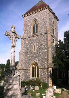
|static_image_caption = [[St Mary's Church, Addington|St Mary's Church]] |
|static_image_caption = [[St Mary's Church, Addington|St Mary's Church]] |
||
}} |
}} |
||
'''Addington''' is an [[List of areas of London|area]] of [[South London]], England, within the [[London Borough of Croydon]]. It is located {{convert|11.1|mi|km|0}} south of [[Charing Cross]]. It lies within the [[Historic counties of England|historic county]] of [[Surrey]]. |
'''Addington''' is an [[List of areas of London|area]] in the east of [[Croydon]] in [[South London]], England, within the [[London Borough of Croydon]]. It is located {{convert|11.1|mi|km|0}} south of [[Charing Cross]]. It lies within the [[Historic counties of England|historic county]] of [[Surrey]]. |
||
==History== |
==History== |
||
Revision as of 15:17, 3 January 2020
This article needs additional citations for verification. (June 2009) |
| Addington | |
|---|---|
 | |
Location within Greater London | |
| OS grid reference | TQ375645 |
| • Charing Cross | 11.1 mi (17.9 km) NNW |
| London borough | |
| Ceremonial county | Greater London |
| Region | |
| Country | England |
| Sovereign state | United Kingdom |
| Post town | CROYDON |
| Postcode district | CR0 |
| Post town | SOUTH CROYDON |
| Postcode district | CR2 |
| Dialling code | 01689[1] |
| Police | Metropolitan |
| Fire | London |
| Ambulance | London |
| UK Parliament | |
| London Assembly | |
Addington is an area in the east of Croydon in South London, England, within the London Borough of Croydon. It is located 11.1 miles (18 km) south of Charing Cross. It lies within the historic county of Surrey.
History
In ancient days named Edintona, then Eddintone.[2] The village lay within the Anglo-Saxon administrative division of Wallington hundred. Addington is thought to be named after Edda, a Saxon. In the Domesday Book, two manors are mentioned, linked with the names Godric and Osward.[3]
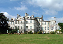
Addington Place, later known as Addington Farm and now called Addington Palace, dominates the village above the church of St Mary the Blessed Virgin Church and The Cricketers pub. The manor house was situated behind the church and was the residence of the Leigh family.[citation needed] From this Leigh family, Patricia Knatchbull, 2nd Countess Mountbatten of Burma is believed to be descended. There is an oft repeated, but false account of a royal hunting lodge, "where King Henry VIII supposedly wooed Anne Boleyn, whose family owned nearby Wickham Court" by West Wickham Parish Church. However, the Anne Boleyn of Wickham Court was the aunt of Queen Anne.[citation needed]
The Palladian mansion was built in the mid-18th century by Barlow Trecothick, from Boston, Massachusetts in the colonial Province of Massachusetts Bay, who returned to England and became an MP and Lord Mayor of the City of London in 1770. After his death without heirs, his nephew James Ivers (later Trecothick), also of Boston, continued his uncle's work and had the grounds laid out by Lancelot Brown.[citation needed] The estate was sold and eventually, as Croydon Palace became too inconvenient and unsanitary, the Addington house and part of the estate was bought for the Archbishops of Canterbury as a country residence.[citation needed] The last Archbishop to use it was Archbishop Benson.[citation needed]. Around 1805 parts of the estate covering what is now New Addington were sold to John Cator of Beckenham Place. This included Castle Hill Farm. Cator left this to George and Henry Sparkes in his Will in 1806, citing "Addington recently acquired from ..... Trecothick" but the land appears as part of the Cator estates in an 1825 Private Act of Parliament allowing the Cators to sell the land as John Barwell Cator was transferring the main estate holdings to Woodbastwick in Norfolk. (sources, Will of John Caor, 1825 Private Act of Parliament)

In the 20th century, technological advances and population growth in the region led to many changes in the way of life for people in Addington. At the beginning of the century, Addington was in the county of Surrey, which had established urban and rural districts to provide services matched to the needs of the differing communities. The parish of Addington was transferred to Godstone Rural District on abolition of Croydon Rural District in 1915. Subsequently, Addington parish was absorbed by the County Borough of Croydon in 1925. Since 1965 the county borough has been part of the London Borough of Croydon within highly urbanized Greater London, which ended over 900 years of administration by the county of Surrey.
New Addington was developed to the south of the existing village from the 1930s onwards.
There are still several old houses and buildings in Addington and, even though there has been some fairly modern building, the village atmosphere is intact in the 21st century, despite its being in Greater London. There is a blacksmith's forge, dating from around 1740, now mainly making ornamental ironwork.[4] The hunt used to meet outside the pub, The Cricketers which has reverted to its former name once again after a temporary change of name.[citation needed] The village co-operative store and post office is now a private house.
The book, Addington: A History was written by Frank Warren, and published by Phillimore & Company in 1984.
St Mary the Blessed Virgin Church
St Mary's Church, Addington is an Anglican church in the village. It is associated with the Archbishops of Canterbury of the 19th century, who lived at nearby Addington Palace. Five successive archbishops are buried at the church: Charles Manners-Sutton (d.1828); William Howley (d.1848); John Bird Sumner (d.1862); Charles Longley (d.1868); and Archibald Campbell Tait (d.1882).
Transport
Rail
Addington Village Interchange (also known as Addington Village tram stop) connects the area with Tramlink services to West Croydon and New Addington. Addington Palace is served by Gravel Hill tram stop on the same line.[5]
Bus
The interchange also provides access to bus routes run by Transport for London, which connect it with areas including Bromley, Croydon, Eltham, Hayes, New Addington, Orpington, Purley and Thornton Heath.
Sport
Cricket has been played in the village since at least the 18th century.
References
- ^ "Farnborough (Kent) Telephone Code. Farnborough (Kent) Area Code". ukphoneinfo.com.
- ^ http://www.domesdaymap.co.uk/place/TQ3863/addington/ Archived 25 February 2015 at the Wayback Machine Domesday Map Online: Addington
- ^ Lysons, Daniel (1792). The Environs of London. Vol. Volume 1, County of Surrey. London. pp. 1–10. Retrieved 25 February 2015.
{{cite book}}:|volume=has extra text (help) - ^ "Online communities". 22 January 2016.
- ^ "Croydon Tramlink : Tram Stops : Gravel Hill". The Trams. Retrieved 16 July 2019.
External links
- Addington in the Domesday Book


