
Essex
Essex | |
|---|---|
| Sovereign state | United Kingdom |
| Constituent country | England |
| Region | East of England |
| Origin | Historic |
| Time zone | UTC+0 (GMT) |
| • Summer (DST) | UTC+1 (BST) |
| Ceremonial county | |
| Area | [convert: needs a number] |
| • Rank | of 48 |
| • Rank | of 48 |
| Density | [convert: needs a number] |
| Ethnicity | 96.8% White 1.2% S. Asian |
Essex (Template:Pron-en) is a ceremonial and non-metropolitan county in the East of England region of the United Kingdom, and one of the home counties. It is located to the northeast of Greater London and is one of the most populous counties in England. Essex County Council is the principal local authority for much of the county, sharing functions with twelve district councils. The county town is Chelmsford. The southern Essex boroughs of Thurrock and Southend-on-Sea are governed separately by unitary authorities. It was established in antiquity and formed the eastern portion of the Kingdom of Essex. Sections of the county closer to London are part of the metropolitan green belt, which prohibits development. It is the location of the regionally significant Lakeside Shopping Centre and London Stansted Airport; and the new towns of Basildon and Harlow.
History
Toponomy
The name Essex originates in the Anglo-Saxon period of the Early Middle Ages and has its root in the Old English Ēastseaxe (i.e. the "East Saxons"), the eastern kingdom of the Saxons.
Ancient origins
In pre-Roman Britain the territories of Suffolk and Essex were home to the Trinovantes tribe, which had grown wealthy through intensive trade with the Roman Empire, contemporary to the decline of Atlantic sea trade as roads and better in-land trade-routes were established in Romanized Gaul. Catuvellaunian and Trinovantian territory was the first to be annexed by the Roman Emperor Claudius in AD 43 when he began his invasion of Britain (Cunliffe, 2001). Colchester was the capital of the province of Britannia, but was attacked and destroyed during Boudica's rebellion in AD 61. Sometime after the destruction, London became the capital of the province of Britannia.
The East Saxon lands bordered those of the Angle peoples of East Anglia (the latter comprising Norfolk, Suffolk and Cambridgeshire). The Kingdom of Essex was traditionally founded by Aescwine in 527 AD, occupying territory to the north of the River Thames, incorporating much of what would later become Middlesex and Hertfordshire, though its territory was later restricted to lands east of the River Lee.[1] Colchester in the north east of the county is Britain's oldest recorded town, dating back to before the Roman conquest, when it was known as Camulodunum, and was sufficiently well-developed to have its own mint. Subsequently the Kingdom of Essex was subsumed into the Kingdom of England and Essex eventually became a shire.
Modern period
Essex County Council was formed in 1889. However, the County Borough of West Ham, and from 1915 the County Borough of East Ham, formed part of the county but were not under county council control.[2] A few parishes were transferred to other counties at this time; parts of Haverhill, Kedington, and Ballingdon-with-Brundon went to Suffolk, and Great & Little Chishill and Heydon to Cambridgeshire. Southend-on-Sea also formed a county borough from 1914 to 1974.[3]
The boundary with Greater London was established in 1965 when East Ham and West Ham county boroughs and the Barking, Chingford, Dagenham, Hornchurch, Ilford, Leyton, Romford, Walthamstow and Wanstead and Woodford districts[2] were transferred to form the London boroughs of Barking, Havering, Newham, Redbridge and Waltham Forest. Essex became part of the East of England Government Office Region in 1994 and was statistically counted as part of that region from 1999, having previously been part of the South East England region. In 1998, the districts of Southend-on-Sea and Thurrock were separated from the shire county of Essex becoming unitary districts.
Governance
The county of Essex is divided into a number of local government districts. They are Harlow, Epping Forest, Brentwood, Basildon, Castle Point, Rochford, Maldon, Chelmsford, Uttlesford, Braintree, Colchester, Tendring, Thurrock, and Southend-on-Sea.[4] The last two boroughs are unitary authorities which form part of the county for various functions such as Lord Lieutenant but do not come under county council control.[5] Essex Police also covers the two unitary authorities.[6]
County council
The county council was formed in 1889, and it meets at the County Hall, in Chelmsford. Before 1938, it regularly met in London near Moorgate, which had been more convenient than any place in the county. It currently has 75 elected councillors. Before 1965, the number of councillors reached over 100. The County Hall, which dates largely from the mid-1930s, and is decorated with fine artworks of that period, mostly the gift of the family who owned the textile firm, Courtaulds, was made a listed building in 2007. The Essex County Council is currently controlled by the Conservative Party. The chairman of the county council 2006-08 was Gerard McEwen of Norton Mandeville near Ongar, and since May 2008, Elizabeth ("Bonnie") Hart, of Hockley.
In November 2008, the council advertised in the European Journal for a private sector "delivery partner" to provide a wide range (and potentially all) of its services.[7] The value of such a contract could amount to £5.4 billion. The arguments advanced in favour of such a step include better service quality and greater efficiency. However, critics including the council's opposition leader have complained of zero consultation before launching this procurement. The council nevertheless hopes to choose a partner before the elections scheduled for June 2009.
The county council has until recently had a partnership with the British Telecom company which has generated a debate locally about the effectiveness of such arrangements. In January 2009, the council's cabinet decided to terminate this contract early. The trade union Unison has questioned the council's competence in managing major private sector contracts. Press reports indicate that BT are considering taking legal action against the council. Unison estimate that the cost to the taxpayer of early termination could be as much as £50m.[8]
The political composition of the county council is as follows.
| Year | Conservatives | Labour | Liberal Democrats | Residents' association | Independent |
|---|---|---|---|---|---|
| 2009 | 60 | 1 | 12 | 1 | 1 |
Geography

The highest point of the county of Essex is Chrishall Common near the village of Langley, close to the Hertfordshire border, which reaches 482 feet (147 m). The ceremonial county of Essex is bounded to the south by the River Thames and its estuary (a boundary shared with Kent County); to the southwest by Greater London; to the west by Hertfordshire with the boundary largely defined by the River Lee and the Stort; to the northwest by Cambridgeshire; to the north by Suffolk County, a boundary mainly defined by the River Stour; and to the east by the North Sea.
The pattern of settlement in the county is diverse. The London Green Belt has effectively prevented the further sprawl of London into the county, although it contains the new towns of Basildon and Harlow, originally developed to resettle Londoners following the destruction of London housing in World War II but since much expanded. Epping Forest also acts as a protected barrier to the further spread of London. Because of its proximity to London and the economic magnetism which that city exerts, many of Essex's settlements, particularly those on or within driving distance of railway stations, function as dormitory towns or villages where London workers raise their families.
Jun2005.jpg)
Part of the south east of the county, already containing the major population centres of Southend and Thurrock, is within the Thames Gateway and designated for further development. Parts of the south west of the county such as Buckhurst Hill and Chigwell are contiguous with Greater London and are included in the Greater London Urban Area. A small part of the south west of the county (Sewardstone), is the only settlement outside Greater London to be covered by a London postal district postcode (E4). To the north of the Green Belt, with the exception of major towns such as Colchester and Chelmsford, the county is rural, with many small towns, villages and hamlets largely built in the traditional materials of timber and brick, with clay tile or thatched roofs.
Economy
This is a chart of trend of regional gross value added of Essex at current basic prices published (pp. 240–253) by Office for National Statistics with figures in millions of Pounds Sterling.
| Year | Regional Gross Value Added[9] | Agriculture[10] | Industry[11] | Services[12] |
|---|---|---|---|---|
| 1995 | 11,422 | 282 | 3,424 | 7,716 |
| 2000 | 14,998 | 205 | 4,335 | 10,458 |
| 2003 | 18,588 | 258 | 5,158 | 13,172 |
The Lakeside Shopping Centre at Thurrock was one of England's first out-of-town shopping centres, which remains popular despite congestion on the nearby M25 motorway and direct competition from Bluewater Shopping Centre.
Industry is largely limited to the south of the county, with the majority of the land elsewhere being given over to agriculture. Harlow is a centre for electronics, science and pharmaceutical companies, while Chelmsford is the home of Marconi (now called telent plc and owned by Ericsson of Sweden since 2005), and Brentwood home to the Ford Motor Company's European HQ. Loughton is home to a production facility for British and foreign banknotes. Chelmsford has been an important location for electronics companies since the industry was born, and is also the location for a number of insurance and financial services organisations, and is the home of the soft drinks producer Britvic. Other businesses in the county are dominated by light engineering and the service sector. Colchester is a garrison town, and the local economy is helped by the army's personnel living there.
Transport

The main airport in Essex is the London Stansted Airport, serving destinations in Europe and North America. Southend Airport, once one of Britain's busiest airports, is undergoing rebuilding, but it still has limited passenger flights to destinations such as the Channel Islands. There are several smaller airfields, some of which owe their origins to Air Force Bases built during World War I or World War II. These are popular for pleasure flights or flying lessons. Examples of these airfields include the Clacton Airfield, the Earls Colne Airfield, and the Stapleford Aerodrome.
The Port of Tilbury is one of Britain's three major ports, while the port of Harwich links the county to the Hook of Holland and Esbjerg. A service to Cuxhaven closed in December 2005. Plans have been put forward to build the UK's largest container terminal at Shell Haven in Thurrock and although opposed by the local authority and environmental and wildlife organisations now seem increasingly likely to be developed.[13][14][15]

Despite the existence of the Dartford Road Crossing to Dartford, Kent, across the Thames River, a ferry for pedestrians to Gravesend, Kent, still operates from Tilbury during limited daily hours, and there are ferries for pedestrians that are operating across some of Essex County's rivers and estuaries during the spring and summer months. The M25 motorway and M11 motorway both cross the county, and the A12 and A13 trunk roads are important radial routes from London. There is an extensive public transport network.
The main railway routes in Essex include two lines from the City of London to Southend-on-Sea, operated by c2c from the Fenchurch Street railway station (including a route via Tilbury) and the National Express East Anglia from the Liverpool Street station, the Great Eastern Main Line from Liverpool Street connecting Harwich and onwards into Suffolk County and Norfolk County, and the West Anglia Main Line from Liverpool Street linking to Stansted and onwards into Cambridgeshire. The Epping Forest district is served by the London Underground Central Line. The routes operated by National Express East Anglia (formerly known as "One") and c2c, are both owned by National Express. There are also a number of branch lines including; the Sunshine Coast Line linking Colchester to the seaside resorts of Clacton-on-Sea and Walton-on-the-Naze. And the Crouch Valley Line linking Wickford to a number of riverside communities via South Woodham Ferrers and Burnham-on-Crouch to Southminster.
South Essex Rapid Transit is a proposed public transport scheme which would provide a fast, reliable public transport service in, and between, Thurrock, Basildon and Southend.[16]
Education
Education in Essex is substantially provided by three authorities being Essex County Council and the two unitary authorities, Southend-on-Sea and Thurrock. In all there are some 90 state secondary schools provided by these authorities, the majority of which are comprehensive, although one in Uttlesford, two in Chelmsford, two in Colchester and four in Southend-on-Sea are selective. There are also various Independent Schools providing education in Essex.[17][18]
Culture

The County's coat of arms comprises three Saxon seax knives (although looking rather more like scimitars) arranged on a red background; the three-seax device is also used as the official logo of Essex County Council having been granted as such in 1932.[19] The emblem was attributed to Anglo-Saxon Essex in Early Modern historiography. The earliest reference the arms of the East Saxon kings was by Richard Verstegan, the author of A Restitution of Decayed Intelligence (Antwerp, 1605), claiming that "Erkenwyne king of the East-Saxons did beare for his armes, three [seaxes] argent, in a field gules". There is no earlier evidence substantiating Verstegan's claim, which is an anachronism for the Anglo-Saxon period seeing that heraldry only evloved in the 12th century, well after the Norman conquest. John Speed in his Historie of Great Britaine (1611) follows Verstegan in his descriptions of the arms of Erkenwyne, but he qualifies the statement by adding "as some or our heralds have emblazed".[19]
The traditional county flower of Essex is the cowslip (Primula veris), locally known as the paigle or peggle, and frequently mentioned in the writings of Essex bucolic authors such as Samuel Bensusan and C. H. Warren. In 2002, the Common Poppy (Papaver rhoeas) was named the county wildflower after a poll of residents (which excluded the cowslip) by the plant conservation charity Plantlife.[20] Samuel Bensusan and others have suggested that if Essex had a county bird, it would be the lapwing (known locally as the peewit) whose lonely cry characterises the Essex marshes known as saltings.
Most English counties have nicknames for people from that county, such as a Tyke from Yorkshire and a Yellowbelly from Lincolnshire; the traditional nickname for a person from Essex is an Essex Calf, so named because the county was famous for rearing beef cattle for sale in London meat markets; calves from the county were famed for their large size and known as 'Essex lions'.[21] Essex is known for being the origin of the political term Essex man, and of the Essex girl joke.[22]
Essex is home to three Football League Clubs Colchester United, Southend United, and Dagenham and Redbridge. Essex is also home to non-league football clubs Chelmsford City, Braintree Town and Thurrock who compete in the conference south.
Cultural references
"Essex Dogs" was the title of a 1997 Blur song.[23] Essex Boys was the title of a 2000 film starring Sean Bean about the demise of a group of Essex gangsters.[24]
Essex Wives was an 2002 LWT reality TV series starring Jodie Marsh.[25]
The satirical puppet show Spitting Image once produced a song titled "Essex is Crap", claiming it was the only UK county with no redeeming features, and describing it as "a boil on the bum of the nation" and "where page 3 girls buy their mum a bungalow".
Landmarks
Over 14,000 buildings have listed status in the county, and around 1000 of those are recognised as of Grade I or II* importance.[26] The buildings range from the 7th century Saxon church of St Peter-on-the-Wall, to the Royal Corinthian Yacht Club which was the United Kingdom's entry in the "International Exhibition of Modern Architecture" held at the Museum of Modern Art in New York City in 1932.
-
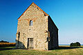 The church of St Peter-on-the-Wall, Bradwell-on-Sea.
 -
 The Grade I listed Hedingham Castle.
 -
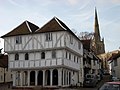 Thaxted Guildhall dating from around 1450.
 -
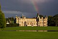 The 17th century Audley End House in Saffron Walden.
 -
 The Royal Corinthian Yacht Club, Burnham-on-Crouch.
 -
 The Sitooterie II of Barnards Farm Gardens, West Horndon


Places of interest
| Key | |
| Abbey/Priory/Cathedral | |
| Accessible open space | |
| Amusement/Theme Park | |
| Castle | |
| Country Park | |
| English Heritage | |
| Forestry Commission | |
| Heritage railway | |
| Historic House | |
| Places of Worship | |
| Museum (free/not free) | |
| National Trust | |
| Theatre | |
| Zoo | |
- Abberton Reservoir
- Arena Essex Raceway
- Ashingdon (The site of the Battle of Ashingdon in 1016)
- Audley End

- Clacton-On-Sea
- Colchester Castle File:CL icon.PNG
- Colchester Zoo File:Zoo icon.JPG
- Colne Valley Railway

- East Anglian Railway Museum

- Epping Forest
- Frinton-on-Sea
- Great Bentley File:Forestry commission logo.svg Home to the Largest Village green in England
- Harlow New Town
- Hedingham Castle File:CL icon.PNG
- Ingatestone Hall
- Kelvedon Hatch (Secret Nuclear Bunker)
- Maldon Historic market town site of the Battle of Maldon
- Mangapps Railway Museum (Burnham-on-Crouch)
- Marsh Farm Country Park
- Mersea Island
- Mistley towers
- Mountfitchet Castle File:CL icon.PNG
- North Weald Airfield
- Orsett Hall
- St Peter-on-the-Wall File:AP Icon.PNG
- Saffron Walden
- Southend Pier
- Thaxted
- University of Essex (Wivenhoe Park, Colchester)
- Waltham Abbey File:AP Icon.PNG
Notable persons
Sister counties and regions
See also
- The Earl of Essex
Notes and references
- ^ Vision of Britain - Essex ancient county boundaries map
- ^ a b Vision of Britain - Essex admin county (historic map)
- ^ Vision of Britain - Southend-on-Sea MB/CB
- ^ Essex County Council - District or Borough Councils
- ^ OPSI - The Essex (Boroughs of Colchester, Southend-on-Sea and Thurrock and District of Tendring) (Structural, Boundary and Electoral Changes) Order 1996
- ^ OPSI - The Essex (Police Area and Authority) Order 1997
- ^ https://essex.bravosolution.com/esop/toolkit/notice/public/tender.do?caller=0&tenderId=tender_22113
- ^ http://www.kablenet.com/kd.nsf/Frontpage/5597D65667799300802575550042691B?OpenDocument, accessed 6 February 2009
- ^ Components may not sum to totals due to rounding
- ^ includes hunting and forestry
- ^ includes energy and construction
- ^ includes financial intermediation services indirectly measured
- ^ Portswatch: Current Port Proposals: London Gateway (Shell Haven) Retrieved 2009-04-15.
- ^ Thurrock Council. (2003-02-26). Shell Haven public inquiry opens. Retrieved 2009-04-15.
- ^ Dredging News Online. (2008-05-18). Harbour Development, Shell Haven, UK. Retrieved 2009-04-15.
- ^ "FAQ".
- ^ Essex County Council. (2006). Secondary School Information. Retrieved 2009-04-15.
- ^ Independent Schools Directory. (2009). Independent Schools in Essex. Retrieved 2009-04-15.
- ^ a b Robert Young. (2009). Civic Heraldry of England and Wales. Essex. Retrieved 2009-04-16.
- ^ Essex Life. (2009-04). County Set of Essex flowers. (p.13). Archant Life Limited.
- ^ Grose, Francis and Egan, Pierce. (1823). Grose's Classical dictionary of th vulgar tongue, revised and corrected, with the addition of numerous slang phrases, collected from tried authorites. London: Printed for Sherwood, Neely, and Jones. Retrieved 2009-04-16.
- ^ http://www.time.com/time/magazine/article/0,9171,1645138,00.html
- ^ http://artists.letssingit.com/blur-lyrics-essex-dogs-nrnm75q
- ^ http://www.imdb.com/title/tt0191996/
- ^ http://www.imdb.com/title/tt0486529/
- ^ Bettley, James. (2008). Essex Explored: Essex Architecture. Essex County Council. Retrieved 2009-04-15.
External links
Neighbouring counties | |
|---|---|
| Unitary authorities | |
|---|---|
| Boroughs or districts | |
| Major settlements (cities in italics) |
|
| Rivers | |