Tmutarakan

Tmutarakan (Russian: Тмутарака́нь) is an ancient city that controlled the Cimmerian Bosporus, the passage from the Black Sea to the Sea of Azov. It was situated on the Taman peninsula, in the present-day Krasnodar Krai of Russia, roughly opposite Kerch.
Greek and Jewish emporium

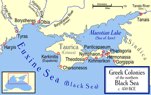
The town was founded on the site of the ancient Greek colony of Hermonassa (Ancient Greek: Ἑρμώνασσα), located a few miles west of the major Tean polis-colony of Phanagoria. Along with Phanagoria and Panticapaeum, Hermonassa was one of the main trade centers for the Bosporan Kingdom; as such, its Greek culture was somewhat tempered by Sarmatian influences. Hermonassa was likely destroyed during the arrival of the Huns in the region, but settlement on the site resumed shortly thereafter. Phanagoria was the capital of the Great Bulgaria during several decades. In the 7th century, the region fell to the Khazars, who built the fortress town of Tamatarkha. Arabic sources refer to it as Samkarsh al-Yahud (i.e., "Samkarsh the Jewish"), perhaps indicating a Jewish majority.[1] Other variants of the city's name are "Samkersh" and "Samkush".[2]
Fortified with a strong brick wall and boasting a fine harbour, Samkarsh was a large city of merchants. It controlled much of the Northern European trade with the Byzantine Empire and Northern Caucasus. The inhabitants included Greeks, Armenians, Russians, Jews, Ossetians, Lezgins, Georgians, and Circassians. After the destruction of the Khazar empire by Svyatoslav of Rus in the mid-10th century, Khazars continued to inhabit the region. The Mandgelis Document, a Hebrew letter dated AM 4746 (985–986) refers to "our lord David, the Khazar prince" who lived in Taman and who was visited by envoys from Kievan Rus to ask about religious matters (possibly in connection connected to the conversion of Vladimir I of Kiev which took place during roughly at the same time).
East Slavic principality

Although the exact date and circumstances of Tmutarakan's takeover by the Kievan Rus is unknown, the Hypatian Codex mentions Tmutarakan as one of the towns Vladimir the Great gave to his sons, which implies that the Russian control over the city was established before Vladimir's death in 1015.[3] The Russian name of the city — "Tmutarakan" — derives from the Turkic tamantarkan (Taman-Tarkhan as in As-Tarkhan); this may have originally been a title of rank.[4]
Vladimir's son Mstislav of Chernigov was the prince of Tmutarakan from 988 to 1036. During his reign, a first stone church was dedicated to the Theotokos, the ruins of it being still visible. In 1066, prince Rostislav Vladimirovich of Tmutarakan was poisoned by a Byzantine official.[5] Afterwards the city belonged to the prince of Chernigov Svyatoslav Yaroslavich[6] and then to the Grand Prince of Kiev Vsevolod Yaroslavich. In 1079, Svyatoslav Yaroslavich appointed a governor (posadnik), who was captured two years later by David Igorevich and Volodar Rostislavich, who seized the city.[7]
In 1083, Oleg Svyatoslavich arrived in Tmutarakan(Arakhan of Tmutar) from the Byzantine Empire and ousted David Igorevich and Volodar Rostislavich, adopted the title of "archon of Khazaria" and made the city his capital.[8] In the 12th century the city was isolated from the Russian mainland by the Cumans and gradually declined. The last recorded mention was in a scroll of 1378.
Decline
The region surrounding the city was part of the Genoese protectorate of Gazaria, based at Kaffa. It was within the territory administered by the Ghisolfi family and was conquered by the Girai Khanate in 1482 and by Russia in 1791.
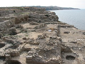
The site of Tmutarakan was discovered in 1792, when a local peasant found a stone with an inscription stating that Prince Gleb had measured the sea from here to Kerch in 1068. The excavations of the site were conducted in the 19th and 20th centuries. The habitation level in places exceeds twelve meters.
During much of the 17th and 18th centuries the area was dominated by Cossacks centered on the town of Taman, which was located near the remains of Tmutarakan. The modern town of Temryuk is nearby. In modern colloquial Russian, "tmutarakan" stands for "the middle of nowhere" (in the sense of being far, far away from civilization).
References

Resources
- Brook, Kevin Alan. The Jews of Khazaria. 2nd ed. Rowman & Littlefield Publishers, Inc, 2006.
- Ivanov, V.V. and V.N. Toporov, 1992. Pchela. In: S.A. Tokarev (ed.) Mify narodov mira. Vol. 2. Moscow: Sovetskaya Entsiklopediya, pp. 354–6.
- Christian, David. A History of Russia, Central Asia and Mongolia. Vol. 1. Blackwell, 1999. p. 298-397.
- Dimnik, Martin. The Dynasty of Chernigov, 1146-1246. Cambridge University Press, 2003. ISBN 0-521-82442-7
- Room, Adrian. Placenames Of The World: Origins and Meanings of the Names for 6,600 Countries, Cities, Territories, Natural Features and Historic Sites. 2nd ed. McFarland & Company, 2005. ISBN 0-7864-2248-3
- Tikhomirov, M. The Towns of Ancient Rus. Moscow: Foreign Languages Publishing, 1959.
- Zand, Michael and Kharuv, Dan (1997). "Krimchaks". Encyclopaedia Judaica (CD-ROM Edition Version 1.0). Ed. Cecil Roth. Keter Publishing House. ISBN 965-07-0665-8

